
As a proud grad of Purdue University, I will very begrudgingly issue this forecast. Buckle up, it could be a fun one.
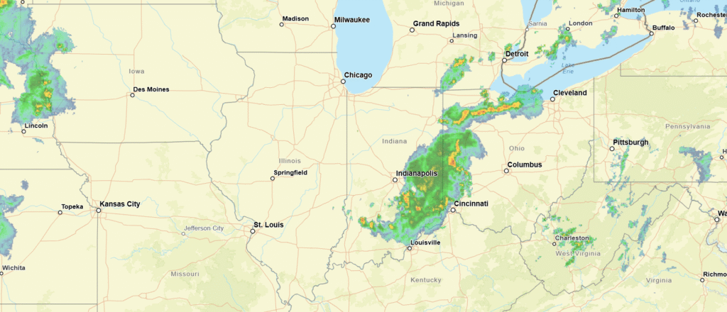
At 1003PM, ET, South Bend was reporting a temperature of 77 degrees with mostly cloudy skies. A band of showers and storms had moved into the eastern part of the state, leaving a humid night for northern Indiana. This should leave the area primed for more sultry conditions tomorrow.
There won’t be a triggering mechanism, save for the latent heat and humidity for tomorrow, but that could be enough for a few stray storms in the afternoon, none of which are likely to be severe. Another band of storms will arrive overnight with a perturbation associated with an area of low pressure moving east through the Canadian Prairies. This complex will hit around midnight and last into the wee hours. The next threat of storms is going to be better organized, and more closely tied to a cold front. This will arrive 24 hours after the first batch, close to midnight Thursday into Friday.
Tomorrow – Afternoon showers and storms, with more action overnight, High 92, Low 73
Thursday – Predawn showers, then storms late, High 89, Low 71
TWC: Tomorrow – Intervals of clouds and sunshine. A stray shower or thunderstorm is possible. High 93, Low 72
Thursday – Mostly cloudy skies with scattered thunderstorms developing later in the day. Some of the storms may become severe. Damaging winds, large hail and possibly a tornado with some storms. High 88, Low 69
AW: Tomorrow -Partly sunny, hot and humid; breezy in the afternoon High 90, Low 71
Thursday – Remaining very warm and humid with periods of clouds and sunshine; severe weather expected at night; be alert and have a way to receive warnings High 89. Low 72
NWS: Tomorrow – A slight chance of showers, then a chance of thunderstorms after 4pm. Partly sunny and hot, High 91, Low 68
Thursday – A 40 percent chance of showers and thunderstorms after 2pm. Partly sunny and hot, High 90, Low 72
WB: Tomorrow – Partly cloudy. A slight chance of showers in the morning then a chance of showers and thunderstorms in the afternoon. High 91, Low 76
Thursday – Partly cloudy. A slight chance of showers in the morning then a chance of showers and thunderstorms in the afternoon. High 86, Low 73
WN: Tomorrow – Partly cloudy with showers and a chance of storms, High 90, Low 70
Thursday – Partly cloudy with showers and a chance of storms, High 90, Low 72
CLI: Tomorrow – Rain showers High 91, Low 69
Thursday – Thunderstorm High 91, Low 71
You can see a band of storms drifting into Ohio. Get used to looking at this, South Bend.