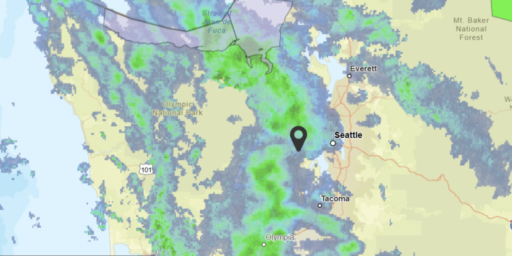
Palm Coast, Florida

Palm Coast is a fairly new addition to the census, having first been developed only starting in 1969, and incorporating 30 years later. Palm Coast is only 25, and in the last 25 years has grown by over 200%. It also has had a history of local wildfires. Will that be a factor with this forecast?

At 1035 PM, ET, Palm Coast was reporting a temperature of 58 degrees and clear skies. In fact, Florida found itself entirely under clear skies, which was surely helping with the temperatures dipping into the 50s in April. Low pressure was bringing a late season snow storm to interior New England, and its attendant cold front had already swept through the Sunshine State and was splitting the Bahamas this evening.
The clear air will continue into the morning, before a ridge builds into the region. Expect a little bit of cloud cover to return in the afternoons of both Friday and Saturday, thanks to some light sea breezes. Flow aloft will be negligible over Florida, so surface features will have a greater role in the daily weather, but the region hasn’t hit the rainy season yet, and rain is not expected even if cumulus fields form. A weak upper level ridge in the southeast will provide another element of stability for the area.
Tomorrow – Partly cloudy, High 75, Low 49
Saturday – Partly cloudy, High 69, Low 50

TWC: Tomorrow – A mainly sunny sky. High 75, Low 50
Saturday – Sunshine. High 69, Low 51

AW: Tomorrow – Nice with plenty of sun High 75, Low 51
Saturday – Partly sunny High 68, Low 52

NWS: Tomorrow -Sunny High 74, Low 50
Saturday – Sunny High 70, Low 50

WB: Tomorrow – Sunny, High 75, Low 46
Saturday – Sunny, High 68, Low 46

WN: Tomorrow – Sunny, High 72, Low 51
Saturday – Sunny, High 67, Low 51

CLI: Tomorrow – Sunny, High 73. Low 50
Saturday – Partly cloudy High 67, Low 50

A brisk north wind as the ridge settles in is going to be the driving factor in those temperatures coming down. Starting cool because of the crystal clear skies, however.

Severe weather now will lead to more tomorrow

There have been quite a few severe storms this evening, from Indiana to Texas, including super cells with detected tornadoes and very large hail. St. Louis was in a tornado warning, and some suburbs saw 2″ diameter hail. There had been a moderate risk for severe weather over Oklahoma that has since been allowed to transition to an enhanced risk, but again, tomorrow, we are looking at a moderate risk, with the bullseye over a different “o” state – Ohio.

It’s absolutely severe season now, so this shouldn’t be a surprise. Be weather aware throughout the Buckeye State and even points south to the Florida Panhandle. Strong, long lived tornadoes are most likely, however, in that red shaded areas.

March Forecaster of the Month

We’ve made it through the third month of the year that had an intense focus on the Midwest. Victoria-Weather, as should be expected, was strong for the month, but not as strong as The Weather Channel, who took the month, and the lead through three months for the year.

OutletForecast Wins (year)
The Weather Channel6.49
Victoria-Weather3.13
Clime2
WeatherNation1.83
National Weather Service1.49
Accuweather1.16
Weatherbug0.67

This warning is pointed the wrong way

As we learned from our last update, today is the only day to be concerned with rain in the Tampa area. To the north off the coast from Cedar Key, the NWS has issued a Marine Warning that looks strange.

Polygons usually expand through the expected storm motion to account for the potential variability of the track. Instead, this one narrows around the storm motion. That’s just a backwards polygon is what that is.

Weather may hamper bridge cleanup efforts this week, will improve

As seen in the video from NBC news, tragedy has befallen Baltimore Harbor, where a cargo vessel leaving the harbor lost power and steamed directly into a support for the Key Bridge, the outermost bridge spanning the Patapsco River, collapsing the span into the River. Two were rescued, though around 20 drivers and construction workers are through to be missing.

Today, this morning, while time is the most critical for whatever recovery can be done to save lives if possible, the weather was at least accommodating. There were clear skies and the Patapsco was calm, which will allow the waterway to be as clear as the waterway can get. It is a busy thoroughfare for maritime traffic and surrounded by a large city, so it is generally murky, and often quite chilly.

Even after the initial recovery is completed, it will be important to continue clearing the wreckage from the mouth of the Patapsco. Baltimore Harbor is one of the busiest on the Eastern Seaboard, and an important source of goods coming into and out of the United States. The longer the harbor is closed, the more likely it is to make a dent on the economy.

Unfortunately, the weather will not be cooperating in these efforts in the next couple of days. There are storms, both rain and snow, from the Great Lakes to the the Florida Panhandle, and this system is headed eastward. It won’t have much energy or much moisture for the coastal Plains, but it will rejuvenate upon reaching the ocean. Even before moisture falls, inflow will blow right through Chesapeake Bay up to Baltimore Harbor.

Rainfall will likely be most intense on Thursday morning, before a reconstituted system can pull off to sea. For the next couple of weeks, the mid-Atlantic looks to expect normal temperatures, but above normal moisture. The falling rain muddies up rivers, and will not help divers without the aid of sonar. Fortunately, for the long term recovery and replacement efforts, near normal conditions are expected around Baltimore, which means warming temperatures and average precipitation.

Hopefully, this can facilitate a rapid clean up and a return to normal for the city of Baltimore. Victoria-Weather extends condolences to those who have lost during this tragedy.

Way off the mark

Last weekend, a system moved through the Great Lakes and eventually spiraled through the mid-Atlantic with a copious amount of rain falling around New York over the weekend. But we are here to talk about Columbus. In my forecast I noted that I thought Friday would be on the overcast side, and little did I know how thick those clouds would be. Temperatures were forecast to hit the low 60s on Friday, and they didn’t even get out of the mid-40s. I did say it would be warmer, and it was only 42 on Thursday! Ugh. There was a three way tie between The Weather Channel, Weather Service and Weathernation.
Actuals: Thursday – High 41, Low 23
Friday – .19 inches of rain, High 45, Low 29

Grade C-D