10:01PM Happy Saturday! I think a lot of people label August as the dog days of summer, but it is pretty similar right now. Hot, humid, not much of a break for a lot of the country. This was a good time of year, when I was still in operational meteorology, to do some training or read. There is some down time.
Jacksonville, North Carolina to Ithaca, New York
We are taking a long day’s drive through the East Coast, covering 665 miles over 5 states and a district. Despite being solidly along the coast, the route will be fairly forgiving, cutting through Raleigh, Richmond, DC and then… Harrisburg? There is enough urban driving, and then the drive into the Poconos to account for, so our speed will only be about 62.5mph on average. Still, 5 states in a day? Not bad.

It’s just that time of year. A low in the Gulf Stream is tailing a boundary into the Carolinas. It’s enough that there is widespread shower activity in the Appalachians tonight, and it’s liable to be a foggy morning as far north as DC. There will likely be showers embedded within the low clouds throughout Virginia as we make our way northward as well. I’ve been in Virginia only a couple of times, and it has rained every time. Is that a thing? Crossing the Potomac, and then heading north into Pennsylvania will be a bit nicer of a time. We will arrive in the Finger Lakes with mostly cloudy skies and a muggy atmosphere. The next boundary will be sliding out of Canada, making sure we don’t have TOO much fun in Ithaca.
Updates 7/7
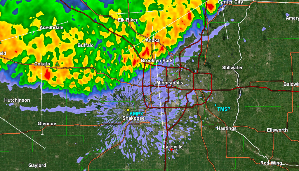
12:03AM: Much coffee will be enjoyed in Minneapolis this morning. Radar just after midnight from the Twin Cities
Winning a home game
Minneapolis is presently just outside of the heat dome that has cooked so much of the southeastern US. The heat hadn’t really even started to build back on the 24th and 25th of June, when we put together a forecast for the home metropolitan area of Victoria-Weather, and temperatures didn’t get out of the 70s. It led to some misty mornings, but the rain had already shipped out of town, and we saw a rare low in the 50s on the 25th. Brr? As you may have suspected, Victoria-Weather was the top outlet, and ended up winning the forecast.
Actuals: June 24th, High: 78, Low 61
June 25th: High 72, Low 51
Grade: B
Updates 7/2
10:21PM: It’s extremely warm in the southeast, and there is a ring of fire, with thunderstorms in the Plains and the Great Lakes, but right now, the world’s eyes are on Vancouver, where Switzerland is playing Algeria in the World Cup. It’s currently 57 degrees in Vancouver. Perfect soccer weather, if they were outdoors. Instead, fans can enjoy a chill when they step out.
Certainly feeling like summer
As we sit on the final day of June, awaiting the beginning of July, the pattern has certainly taken a turn for summer. The spring season is marked by strong cyclones and supercells that bring tornadoes to the southern Plains and Dixie Alley. It rightfully gets a lot of attention for the destruction and disruption it can bring.
Spring storms are brought by the changing airmasses, from cool and dry winter to hot and humid summer. Eventually, summer takes hold and it just gets incredibly hot and humid in the South. There are a few afternoon thunderstorms, essentially every day, but they are fueled directly off of one air mass, and not a clash. That’s where we are now, it’s overwhelmingly hot, especially in the southeast.
This is also the time of year where fuel for thunderstorms is the greatest, so whenever flow is from the west, and we get low pressure in the lee of the Rockies, we can get strong to severe thunderstorms in the Plains. This isn’t necessarily colder air, just drier air, but this burst of energy can ripple through the atmosphere, and the weakest of boundaries offer as firing lines for thunderstorms to ride along.
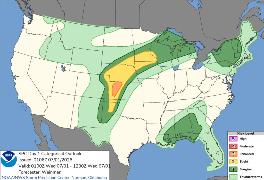
Tonight’s outlook shows exactly what a typical summer time severe set up should look like. There is the origin of the storms in western Kansas, where they may get a bit twisty, with tornadoes more likely. From Nebraska to Minnesota, one of those ripples in the air mass will act as a guide for a batch of storms with howling straight line winds – a true derecho. It’s almost midnight, and it is producing nearly 80mph winds in central Nebraska.
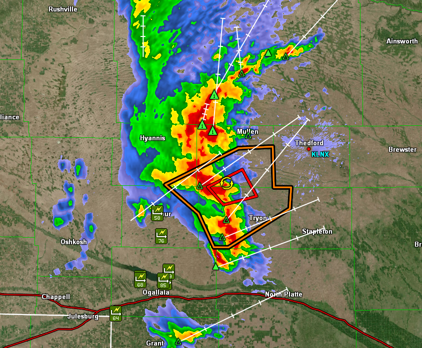
Often times, there are embedded tornadoes within squalls like this, but really, a tornado warning might just be what it takes to pay attention to a storm that will mess things up pretty well on its own.
Given the copious amounts of fuel on hot humid days, long track derechos are more likely. Even if they are derechos, lines of thunderstorms occur more frequently than the cellular storms of spring. Even in New York a line of storms is moving through upstate New York, feasting on the atmospheric moisture, rather than conflicting airmasses.
Storms like our Nebraska storm, above are also called mesoscale convective complexes. Our air mass storms in the southeast erupt when surface heating reaches a point that causes the moist air to become buoyant, rising, condensing and forming cumulonimbus clouds and eventually, thunderstorms. Those are the same mechanics for our storm in the Plains to initiate, but there is a different mechanism for its sustenance.
As I hope you have learned by now, warm or moist air rises. Typically, this is the surface warming up, but overnight, especially with the elevated thunderstorms we are seeing, cooling from the top down after nightfall is what draws those parcels of air upward. They continue to track along whatever phantom boundary, or wave or ripple exists, and they tend to roll on until that boundary tapers away.
Our Nebraska storms show no signs of dying out quite yet. Look for a loud wake up in Sioux City Iowa and Rochester, Minnesota.
The heat always wins
We looked at Longview in the middle of the month, when east Texas was in the midst of a stormy pattern. We expected that pattern to continue, and for a bit of cooler air to funnel into the region. At the very least, it seemed like overcast skies would conspire to keep it cooler. Not so much. In fact, the day with the most rain, Saturday the 20th, was also the day with the warmest temperatures. Temperature forecasts were not great, overall, but they were passable. The real differentiator, though, was the spot of rain seen early on Sunday. The top spot belonged to a trio, Victoria-Weather, Accuweather and Clime. I did forget to add the forecast for WeatherNation, so they get the consensus numbers. Sorry, WeatherNation.
Actuals: June 20th, .55″of rain in thunderstorms, High 89, Low 74
June 21st, .01″ of rain, High 87, Low 75
Grade: C
Coming Soon…
We are now to the heat of summer, no doubt about it. We have several forecasts and road trips coming your way.
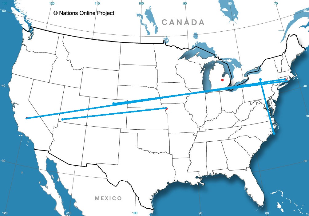
Road trip from Jacksonville, North Carolina to Ithaca, New York
St. Joseph, Missouri
Road Trip from Ithaca to St. Joseph (forgot that line!)
Road Trip from St. Joseph, Missouri to St. George, Utah
Saginaw, Michigan
Fresno, California
Norwich, Connecticut
Road trip from Fresno – Norwich
Road trip from Norwich to Fort Collins, Colorado
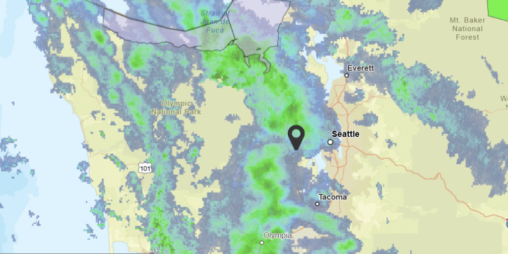
Bremerton, Washington
We are going to the top left corner of your map of the United States tonight. I assume your map is like mine, and has Alaska with Hawai’i in their own insets at the bottom of the page.
At 1156AM, PT, Bremerton was reporting a temperature of 57 degrees with overcast skies. Temperatures were kept in check by the cloudy skies. A strong jet curled around Vancouver Island into the Pacific Northwest, leading to regionwide instability. As the jet curls inland, steady bands of rain will continue across the Olympic Peninsula and Puget Sound, particularly through tomorrow.
Surface organization is always murky in the Pacific Northwest, so the best indicator of the future precipitation in the region will be the upper level flow. As the jet moves inland, it will weekend rather than successfully advect eastward. Whatever surface circulation lingers will move a bit inland by Sunday, with light shower activity continuing to spin back into the terrain of the Cascades and Olympic Mountains, resulting in ongoing fog and clouds, with intermittent drizzle for Bremerton.
Tomorrow – Scattered showers through the day, High 67, Low 51
Sunday – Isolated showers, with overcast skies and haze, High 66, Low 52
TWC: Tomorrow – Mostly cloudy. High 68, Low 50
Sunday – Overcast. High 69, Low 50
AW: Tomorrow – Mostly cloudy with a couple of showers High 67, Low 51
Sunday – Mostly cloudy High 69, Low 51
NWS: Tomorrow – A 40 percent chance of rain, mainly between noon and 4pm. Partly sunny, High 64, Low 51
Sunday – Mostly cloudy, High 66, Low 51
WB: Tomorrow – Partly sunny. A chance of rain in the morning then a slight chance of rain late in the morning. A chance of rain in the afternoon High 66, Low 51
Sunday – Mostly cloudy. High 67, Low 52
WN: Tomorrow – Partly cloudy with scattered showers, High 65, Low 51
Sunday – Mostly cloudy, High 67, Low 51
CLI: Tomorrow – Rain Showers, High 66, Low 47
Sunday – Light rain showers, High 67, Low 47
This will be interesting, as Bremerton doesn’t do a great job of reporting rain in their observations. Let’s see how it all plays out! Check this out: I started writing this last night and grabbed a still of the radar then. Not much changed!
Minneapolis, Minnesota
Minneapolis is a near and dear to my heart. Most of my life, I’ve lived within the town’s orbit, and it’s always a fun occasion to be able to assemble a forecast for the Mill City.
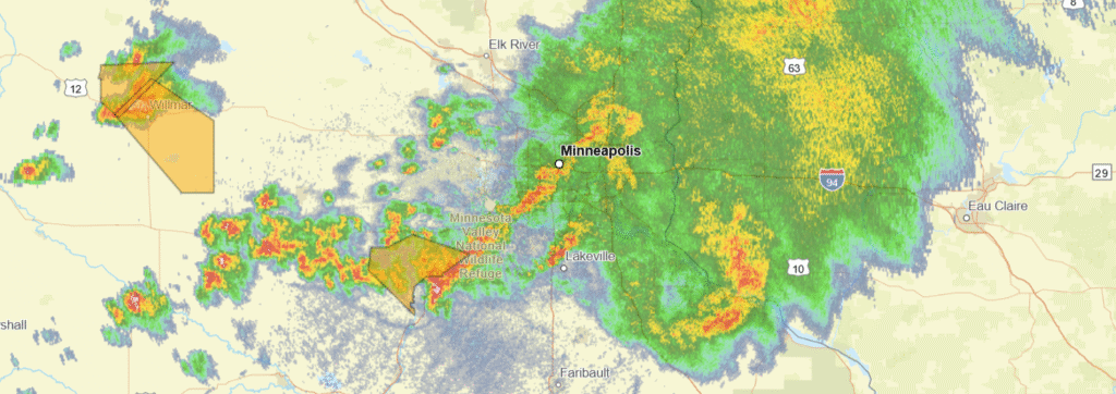
At 415PM, Minneapolis was reporting heavy thunderstorms and a temperature of 63 degrees. A batch of showers and storms has followed a warm front through the day from North Dakota, and is now battering the Twin Cities with heavy rain and some convection. West of this batch of storm activity, more storms were developing underneath the warm front, and ahead of a cold front that was chasing the warm front. These storms have a history of being severe, however given the air modification currently being performed by the complex moving through, they won’t be severe, if they can even hold together, when they reach Minneapolis.
The low pressure moving in the Upper Midwest is backed by a bit of upper level support, however the most kinetic action is related to heat and lee troughing in the High Plains. This will cause the system to dawdle as it moves towards Lake Superior, and redirected moisture towards low pressure in the Plains will sap precipitation potential as the week wears on. Don’t be surprised by a mostly cloudy week, even with rain generally north and east from town.
Tomorrow – Rain ending before sunrise, mostly cloudy, a bit breezy, High 77, Low 60
Thursday – Partly to mostly cloudy, High 73, Low 58
TWC: Tomorrow – Intervals of clouds and sunshine. A stray shower or thunderstorm is possible. High 75, Low 61
Thursday – Cloudy. High 78, Low 56
AW: Tomorrow – Variable clouds with a couple of showers and a thunderstorm High 77, Low 60
Thursday – Considerable cloudiness High 75, Low 54
NWS: Tomorrow – A 30 percent chance of showers and thunderstorms, mainly between 1pm and 3pm. Partly sunny, High 76, Low 60
Thursday – Mostly sunny, High 75, Low 55
WB: Tomorrow – Partly sunny. A 20 percent chance of thunderstorms in the afternoon. High 77, Low 60
Thursday – Mostly sunny. High 74, Low 58
WN: Tomorrow – Partly cloudy with showers and chance of storms, High 76, Low 60
Thursday – Partly cloudy, High 75, Low 55
CLI: Tomorrow – Light rain showers, High 74, Low 60
Thursday – Overcast, High 74, Low 56
A stormy night that is expected to continue for a while. It’s pretty messy on radar this evening in Minneapolis!