Gulfport, Mississippi

If you haven’t ever been to Gulfport, or know where it is located, Gulfport is a port on the Gulf.

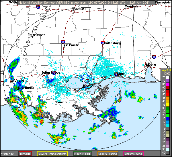
At 853AM, CT, Gulfport was reporting a temperature of 86 degrees with clear skies. It’s the season for light off shore convection, and indeed, there is already some off the Mississippi Delta. These Gulf Coast storms tend to be more widespread than anticipated in model guidance, and an intense rain shower cannot be ruled out today.
In the parlance, the Gulf is “open” meaning there is little to no counterflow to sea breezes, and sultry air is free to invade the coastal areas. This tends to mean that in the afternoon, there will be enough instability for occasional showers and thunderstorms, particularly a few miles inland where the sea breeze loses momentum, with storms then drifting back towards the coast as the sun sets. This will probably be the pattern each of the next two days in Gulfport, and truly, the entire Gulf Coast.
Tomorrow – Mostly cloudy with a few thunderstorms, High 93, Low 76
Thursday – Mostly cloudy with a few thunderstorms, High 95, Low 76

TWC: Tomorrow – Partial cloudiness early, with scattered showers and thunderstorms in the afternoon. High 90, Low 76
Thursday – Sunshine and clouds mixed. A stray shower or thunderstorm is possible High 93, low 77

AW: Tomorrow = Intervals of clouds and sunshine High 92, low 76
Thursday – Mostly sunny High 95, Low 76

NWS: Tomorrow – A 30 percent chance of showers and thunderstorms, mainly after 1pm. Partly sunny High 91, Low 76
Thursday – Mostly sunny, high 93, Low 76

WB: Tomorrow – Partly cloudy, slight chance of showers and thunderstorms in the morning, then chance of showers and thunderstorms in the afternoon, High 91, low 75
Thursday – Sunny in the morning then partly cloudy with a 20 percent chance of showers and thunderstorms in the afternoon High 93, low 75

WN: Tomorrow – Partly cloudy with scattered storms, High 92, low Low 77
Thursday – Partly cloudy, High 93, Low 77

FIO: Tomorrow – Humid and partly cloudy throughout the day. High 91, low 78
Thursday – Humid and partly cloudy throughout the day. High 93, Low 78

Hot. Humid. Mississippi. Here is some of this morning’s off shore convection on radar.

No rain and nasty temps

It was plenty warm in Nashville last week. temperatures soared into the low 90s in Nashville as the weekend commenced last week. there was a threat of some pop up showers and storms as is often the case south of the Ohio River this time of year, but Music City dodged the drops. The dry forecast meant Forecast.io was able to slip in front and win the forecast.
Actuals: Friday – High 91, Low 67
Saturday, High 92, Low 72

Grade: A-C

A hot weekend is on it’s way

Take a look at the high temperatures coming your way this weekend, middle America.

Now, this map, in my opinion, is a bit misleading, becaue we have been groomed tro believe that red is hot and yellow is merely warm. Look again, though, and see that yellow is 90. Triple digits will be possible as far north as central South Dakota tomorrow, even if the color scale is a touch muted.

This doesn’t take into account the humidity that will flow northward a long with the heat. Excessive Heat advisories are in place across the region this weekend, as far north as Minnesota thanks to heat indices expected to reach the 110s in some northern states. After a cool start, this will feel even hotter for local residents.

Double Duque’s

Does that title make you think of Dubuque? it did in my head, but I’m not sure about it now, seeing it on paper. Anyways, this is in reference to the fact that we had two forecasts in Dubuque last week. Anthony made a forecast on the 18th, and I followed up on the 21st. There was no overlap in forecast period, and I can say that we both defeated 2 of our rival outlets. The difference was that Anthony tied all of the other ones, and The Weather Channel throttled the rest of us on the 21st. So congrats everyone, you pretty much all won (except Weatherbug and Forecast.io) on the 18th, but The Weather Channel really stood out on the 21st.
Actuals: Wednesday, Trace of rain, High 75, Low 57
Thursday, High 78, Low 67
Saturday – .01 inches of rain, High 78, Low 57
Sunday – .32 inches of rain, High 78, Low 67

Grade: B-C (18th) A-C (21st)

Nashville, Tennessee

The Music City is our stop for this forecast. I think it’s an unfair sobriquet, frankly, because while Nashville is the home of Country Music, Memphis, just down the road, has a lot of jazz and blues history, as well as Graceland and Elvis. Gosh darn it, Tennessee should just be the Music State.

At 853AM, CT, Nashville was reporting a temperature of 80 degrees, even at this early hour. A remnant vorticity maximum was bringing thunderstorms to western Tennessee, though more broadly, the Tennessee Valley was under a broad ridge of high pressure.
After the vort max subsides, It will be warm high pressure taking hold in central Tennessee. Generally speaking, this usually means isolated showers and storms in the summertime, and that will be no different tomorrow and especially Saturday. It will be more active to the north, synoptically, but scattered afternoon showers and storms are more likely than not throughout the southeast.
Tomorrow – Stuffy, with a chance of afternoon showers and storms, High 88, low 70
Saturday – A little clearer, but still a threat for afternoon thunder, High 90, Low 71

TWC: Tomorrow – Partly cloudy with afternoon showers or thunderstorms. High 92, Low 69
Saturday – Partly cloudy. A stray shower or thunderstorm is possible. High 94, Low 71

AW: Tomorrow – Mostly cloudy, a thunderstorm High 91, Low 69
Saturday – Partly sunny, warm; a shower or thunderstorm in spots in the afternoon High 92, low 70

NWS: Tomorrow – A 20 percent chance of showers and thunderstorms after 1pm. Mostly sunny High 92, Low 69
Saturday – A 20 percent chance of showers and thunderstorms. High 92, low 70

WB: Tomorrow – Partly cloudy, a 20 percent chance of showers and thunderstorms in the afternoon, High 89, Low 70
Saturday – Partly cloudy, a 20 percent chance of showers and thunderstorms High 90, Low 70

WN: Tomorrow – Partly cloudy with isolated storms, High 92, Low 69
Saturday – Partly cloudy, a 20 percent chance of showers and thunderstorms in the afternoon, High 92, Low 70

FIO: Tomorrow – Rain tomorrow evening. High 91, Low 70
Saturday – Partly cloudy throughout the day. High 92, low 72

Here are the scattered storms over western Tennessee. Expect a lot less organization as the weekend rolls around.

Canton, Ohio to Dubuque, Iowa

One day. One long day, and four states, those are the stats on this Midwestern trek. It will take a little over 9 hours, albeit those will be traffic slogged in Chicago, to cover 608 mles. How bad will traffic be? Google suggests an alternate route through Indianapolis that is less than an hour longer, but covers 72 more miles. The pace of our route is 66.4mph, which doesn’t seem daunting, but it does seem optimistic.

Canton, Ohio, via VisitCanton.com

Low pressure in the Great Lakes is bringing some northerly flow to the Northern Plains and cycling in batches of rain and isolated thunderstorms to most of our route. The low is shifting north and a little east, however, and by tomorrow, the Ohio and Indiana portions of our journey will be in the clear. A second volley of wet weather will cycle into the region late in the day tomorrow, and while most of the activity will be heavy clouds in northern Illinois, we should expect some rain in spits and starts between Chicago and the Quad Cities, with thinner clouds bout those same spots of rain between Davenport and Dubuque. Not much, but it will be there, probably when you are bringing luggage to your hotel.

By Dirk – originally posted to Flickr as Dubuque Iowa, CC BY 2.0, https://commons.wikimedia.org/w/index.php?curid=7121481

Dubuque, Iowa

Yes! We are forecasting for the same city in Iowa twice in a week. Anthony and I are operating on slightly different calendars, and there was overlap this week. Which of us does Dubuque best?

At 853AM, CT, Dubuque was reporting clear skies and a temperature of 63 degrees. Winds from the east were picking up, feeding into a line of very strong thunderstorms that were barreling down I-80, passing through Marshalltown on their way to Cedar Rapids and Iowa City. The heaviest activity will remain south of Dubuque, but Dubuque won’t be completely unscathed when all is said and done.
The line of storms is a true derecho, following a stationary front that runs south of Dubuque towards Missouri and into Kentucky and Tennessee. The northwestern part of the boundary is poised to lift further north as an area of low pressure moves through Iowa, reinvigorating the chance for showers and storms later this evening. The low that lifts north is just a mild perturbation in a broader, progressively weakening system in the northern Plains. The weakening of this parent low means that clearing will be slow to come to Deubuque, and this weekend will be plagued by chances of rain throughout the weekend as the system occludes over eastern Iowa. There may be a stray thunderstorm embedded within showers.
Tomorrow- Overcast with rain and some thunderstorms, High 74, Low 56
Sunday – Rain, heavier and with embedded storms late, High 77, Low 64

TWC: Tomorrow – Cloudy early. Scattered thunderstorms developing later in the day High 78, Low 57
Sunday – Scattered showers and thunderstorms. High 80, Low 67

AW: Tomorrow – Cloudy, humid; a shower or thunderstorm in spots in the afternoon High 76, low 58
Sunday – Remaining cloudy, thunderstorms, strong late; humid High 80, Low 68

NWS: Tomorrow – Showers and thunderstorms likely, mainly before 7am. Mostly cloudy, High 78, Low 60
Sunday – Showers and thunderstorms likely. Mostly cloudy, High 81, Low 68

WB: Tomorrow – Mostly cloudy. Showers and thunderstorms likely in the morning, then a chance of showers and thunderstorms in the afternoon. High 74, Low 58
Sunday – Showers and thunderstorms likey, High 77, Low 68

WN: Tomorrow – Mostly cloudy with scattered storms, High 78, Low 60
Sunday – Mostly cloudy with thunderstorms likely, High 81, low 68

FIO: Tomorrow – Rain overnight and in the morning. High 72, Low 61
Sunday – Possible light rain throughout the day. High 80, Low 69

I’m a little cooler than most, especially on Sunday, but my logic is this: Rainy, cloudy days rarely happen when it’s 80 out. Here is the radar, with a line of storms screaming through southern Iowa.

Severe weather lingering to the south

Before we begin, let’s take a moment to appreciate the duck like appearance of today’s severe weather outlook.

Quack quack quack. Now, the breast meat of this duck-look is featuring an enhanced risk of severe weather. Looking at the bulk of the severe weather in the forecast, it is apparent that here is a cold front running roughly from the Great Lakes to the Red River Valley, with a second embedded low over north Texas to inflame any severe storms in the region.

There is something mildly unusual about this particular forecast, and it has been part of an ongoing trend to the spring and early meteorological summer. It’s been so cold in the central US that the bullseye for severe weather hasn’t really shifted as far north as it usually does this time of year.

Here is the SPC climatology for severe weather for 6/19s through history.

Certainly, there has been severe weather further north this season, such as the tornadoes in Dayton and Jefferson City, and Kansas and Nebraska have had some severe storms as well, but the particularly cool start to summer in the Upper Midwest has kept the Great Lakes fairly quiet so far this season, it has also lead to a prolonged storm season through Texas and Louisiana.

With the long term outlook for the next couple of weeks turning warmer in the center of the country, the severe threat looks to be moving further north. Additionally, a standing trough coming to the west looks to set up a clash of air masses in the Dakotas late in the month to the beginning of July. It’s certainly too far out to make any specific predictions, but it certainly looks like we are on our way to course correction through the middle of summer.

Late night, no worries

I think it’s ok that Victoria-Weather and a couple of other outlets left the mention of rain out of the forecast in Omaha for yesterday. There were only a couple of drops, and they all came in the 10 o’clock hour, after everyone should have been in bed anyway. I guess it doesn’t really work like that though, so we have to give credit to The Weather Channel and the resurgent Weatherbug, who tied atop the forecast, thanks in part to their dash of Monday precip.
Actuals: Sunday – High 86, Low 64
Monday – Rain reported, not measured, High 82, Low 66

Grade: B-C