Yes! We are forecasting for the same city in Iowa twice in a week. Anthony and I are operating on slightly different calendars, and there was overlap this week. Which of us does Dubuque best?
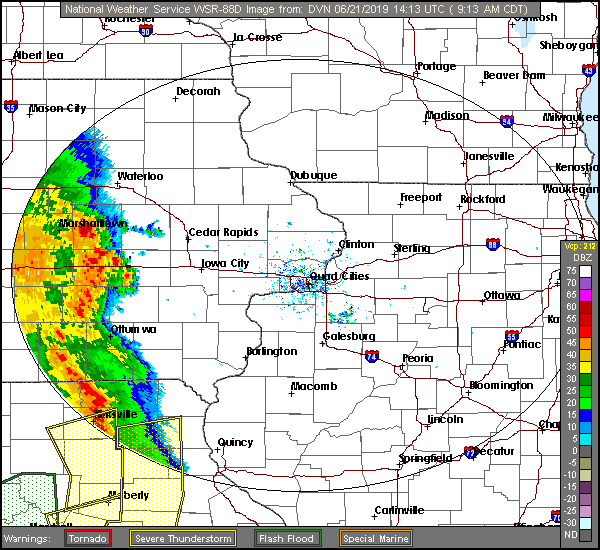
At 853AM, CT, Dubuque was reporting clear skies and a temperature of 63 degrees. Winds from the east were picking up, feeding into a line of very strong thunderstorms that were barreling down I-80, passing through Marshalltown on their way to Cedar Rapids and Iowa City. The heaviest activity will remain south of Dubuque, but Dubuque won’t be completely unscathed when all is said and done.
The line of storms is a true derecho, following a stationary front that runs south of Dubuque towards Missouri and into Kentucky and Tennessee. The northwestern part of the boundary is poised to lift further north as an area of low pressure moves through Iowa, reinvigorating the chance for showers and storms later this evening. The low that lifts north is just a mild perturbation in a broader, progressively weakening system in the northern Plains. The weakening of this parent low means that clearing will be slow to come to Deubuque, and this weekend will be plagued by chances of rain throughout the weekend as the system occludes over eastern Iowa. There may be a stray thunderstorm embedded within showers.
Tomorrow- Overcast with rain and some thunderstorms, High 74, Low 56
Sunday – Rain, heavier and with embedded storms late, High 77, Low 64
TWC: Tomorrow – Cloudy early. Scattered thunderstorms developing later in the day High 78, Low 57
Sunday – Scattered showers and thunderstorms. High 80, Low 67
AW: Tomorrow – Cloudy, humid; a shower or thunderstorm in spots in the afternoon High 76, low 58
Sunday – Remaining cloudy, thunderstorms, strong late; humid High 80, Low 68
NWS: Tomorrow – Showers and thunderstorms likely, mainly before 7am. Mostly cloudy, High 78, Low 60
Sunday – Showers and thunderstorms likely. Mostly cloudy, High 81, Low 68
WB: Tomorrow – Mostly cloudy. Showers and thunderstorms likely in the morning, then a chance of showers and thunderstorms in the afternoon. High 74, Low 58
Sunday – Showers and thunderstorms likey, High 77, Low 68
WN: Tomorrow – Mostly cloudy with scattered storms, High 78, Low 60
Sunday – Mostly cloudy with thunderstorms likely, High 81, low 68
FIO: Tomorrow – Rain overnight and in the morning. High 72, Low 61
Sunday – Possible light rain throughout the day. High 80, Low 69
I’m a little cooler than most, especially on Sunday, but my logic is this: Rainy, cloudy days rarely happen when it’s 80 out. Here is the radar, with a line of storms screaming through southern Iowa.