Green Bay, Wisconsin

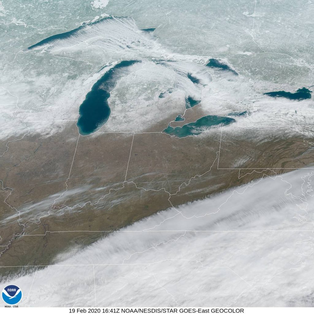
When you think of beachfront communities, I’m not sure Green Bay and Lake Michigan often come to mind. Northeast of Green Bay is Door County, though, which is an idyllic vacation spot. In the summer, though, probably not right now.

At 953AM, CT, Green Bay was reporting clear skies and a temperature of only 7 degrees. Clear dry air prevailed in the Dairy State thanks to the west winds, though some clouds were seen in the Upper Peninsula of Michigan thanks to flow coming off of Lake Superior, which has remained open this winter.
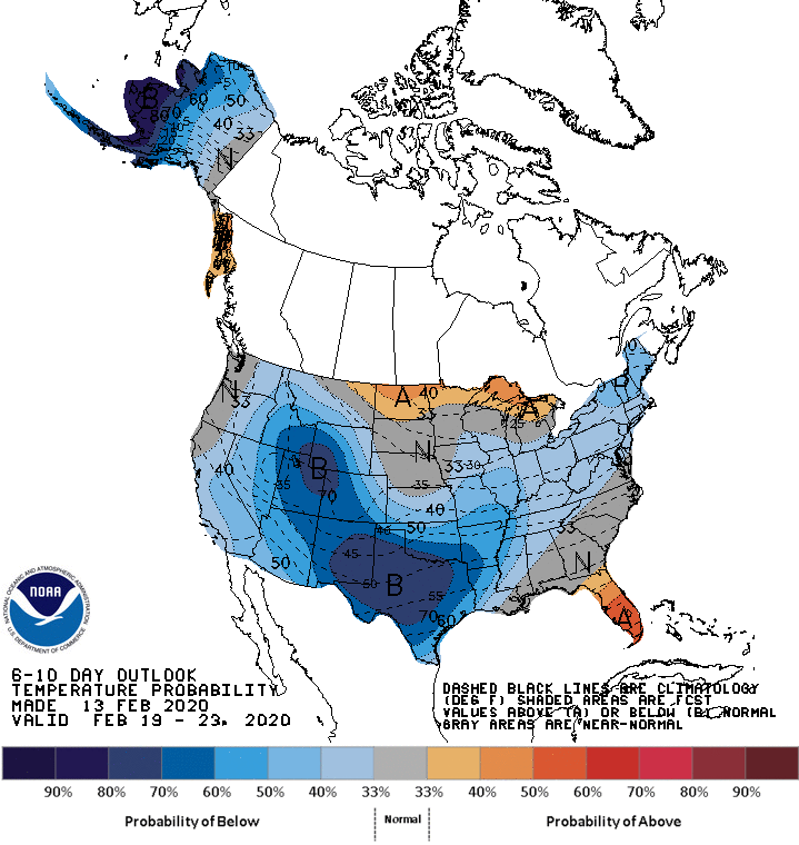
Surface high pressure is in control thanks to a broad trough lying along the southern third of the country. Unfortunately, with the jet as far south as it is, warm air is pinned in the Gulf, and the ridge is particularly chilly. A shortwave upper level trough is translating through the Great Lakes as well, functioning similarly to a thermal trough, though mostly because it is left without a source of moisture. Still, as it pivots away from the area, a warm up can be anticipated simply due to the increased sun angle as we approach spring.
Tomorrow – Mostly sunny, High 16, Low -4
Friday – Sunny and warmer, High 34, low 6

TWC: Tomorrow – Mainly sunny. High 15, Low -3
Friday – A mainly sunny sky high 33, Low 5

AW: Tomorrow – Very cold with plenty of sunshine High 16, Low -3
Friday – Not as cold with plenty of sun High 33, low 6

NWS: Tomorrow – Sunny, High 16, Low -4
Friday – Sunny, High 32, low 5

WB: Tomorrow – Sunny, High 13, Low -3
Friday – Sunny, High 31, Low 6

WN: Tomorrow – Sunny, High 16, Low -4
Friday – Sunny, High 32, low 5

FIO: Tomorrow – Clear throughout the day. High 16, low -4
Friday – Windy in the afternoon and evening. High 33, Low 4

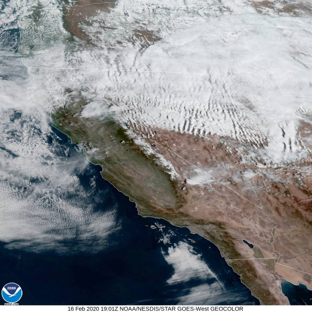
Brr! Ok, this is probably another reason most people don’t think of Green Bay and beaches. here is the satellite imagery. A lot of the white is actually snow on the ground, rather than clouds.

A clearing wind from the northwest

We needed to rely heavily on model guidance for our forecast in San Jose, thanks to tricky terrain and a dearth of information to the west. Some of it is still instinct, however, and many people shouldn’t have trusted theirs. On Monday, skies cleared a bit thanks to a brisk northwest wind, and temperatures popped into the 70s, but that was the only real forecast surprise for model adherents. Victoria-Weather and The Weather Channel collected the top spot, which is interesting, because the robot forecaster actually ended up last.
Actuals: Monday – High 71, Low 48
Tuesday – High 69, low 45

Grade: B-C

Persistent patterns lead to problems

If you have been tracking the weather in the southeast over the last several weeks, you know that the we’ve had a bit more early severe weather than last year, particularly in the Dixie Alley of Mississippi, Alabama and states surrounding them.

The issue hasn’t really been the individual severity of these storms, but rather the frequency with which they have been occurring. Big thunderstorms often bring heavy rains, and while the southeast is uniquely equipped to contend with a higher water content than most places in the country, they have simply seen these storms too often.

Presently, the Mississippi is over it’s banks in Natchez, while the Tombigbee River in Alabama from Gainesville to Mobile is at moderate flood levels. The Pearl River, particularly in Jackson, is where the flooding is presently the worst. The Pearl is currently cresting at eight feed above flood stage.

If we were expecting to stay dry for a while, I would confidently say that the worst will soon be over for residents of Jackson and the surrounding environs, however the forecast calls for more rain. Many parts of Mississippi, including Jackson, will see at least a couple more inches of rain through Thursday, leading the WFO in Jackson to pain the region in Flash Flood watches and warnings.

Mississippi’s terrain is porous and will be able to absorb the excess faster than many places, but it is still significant to see flash flooding forecast over such a broad swath of land. The next round of rain and thunderstorms has already popped up south of Grenada.

Eastern Seaboard gets a reprieve

Do you know what this site has been missing this winter? Posts about snow storms on the East Coast. this isn’t just because of our pared down content schedule either; there just hasn’t been any snow to speak of south of New York, and the biggest features have waited until they are over the Atlantic to really take off.

New York hasn’t been particularly snowy either, but Philadelphia and Washington have seen less than an inch of snowfall accumulation all season. Take a look at the accumulated totals for the mid-Atlantic to date this season.

The light blue shadings are the 0-1″ range, which includes southern New Jersey to northern North Carolina, at which point the total accumulations really taper off. Things are light north of there as well, with under half a foot falling from the Cape to southeastern Pennsylvania.

It hasn’t been dry along the East Coast. There have been plenty of warmer core systems that brought enough rain to make sure the soil stays saturated. There have also been cold snaps from time to time. The problem for snow lovers in the Beltway is that those two things haven’t phased.

It’s still only the middle of February, so hope is not all lost for people want to see some snow this season, but for those that aren’t snow aficianados, we are already almost out of the woods for the season, and it has passed with very little headache.

Storm “Dennis” batters the British Isles

A strong storm with an origin in the southern United States underwent explosive cyclogenesis (a ‘bomb cyclone’) in the North Atlantic over the weekend and slammed into Ireland and the United Kingdom, bringing strong winds, heavy rain and disruption through the region.

Many European meteorological agencies give names to all significant systems. In this case, the United Kingdom, Ireland and the Netherlands form a cooperative that ascribes names to storms, much like the National Hurricane Center does to hurricanes. This is a tried and true method of weather agencies both to document and streamline the notifications of the strongest storms (and a lot of that is lost when networks give their own names to snow storms).

But the politics and naming conventions aside, Dennis was one of the strongest storms to ever move across the north Atlantic, thanks to a strong jet structure that fostered the rapid development. Usually, and once again this was the case, when there is such a rapid development, it is accompanied by very gusty winds.

With Dennis, however, the most significant impact was with the water. Churning seas claimed the lives of a couple of British citizens, while flood waters and heavy rains lead to the death of another man in Wales, and a woman was swept away by floodwaters in Worcestershire. There have also been stories of ships (though abandoned) washing ashore in Ireland thanks to the churning seas, and flooding as far away as Sweden as Dennis made his way towards the Baltic.

The storm has mostly shifted out of Europe, though a cold front remains particularly active in Russia and Belarus, though it tails as far west as France. A few snowflakes will fall in Scotland and northern England today, while runoff will continue to cause rivers to rise on Great Britain for at least another day or so.

To continue to follow Dennis and his lingering impacts, as well as learning more about individual tales and specific happenstances brought about by this massive storm, BBC News continues to have live updates about his wrath.

Visalia, California to San Jose, California

Just a quick little trek today, as we head about 3 hours from the Central Valley to the Bay Area. Such a change in geography over only 191 miles. We’re going to cover the ground at a pace of 61.9mph. That’s not very fast, but these short trips aren’t known for their high rates of speed. Nor are California roads.

Visalia, California

Fortunately for our quick drive on Monday morning, the pattern, already pretty good, is going to get even better on the West Coast. A ridge is setting up over California, which may lead to a bit of a breeze, but not much else. The big concern will be traffic, but we’ll get to San Jose around lunch time, so hopefully, it won’t be bad!

San Jose, California

San Jose, California

The Bay Area of northern California is a complicated weather scene thanks to the water, the changing terrain and the fact that there isn’t a heck of a lot of data immediately to the west of there. Fingers crossed, models don’t fail us now!

At 1053AM, PT, San Jose was reporting a temperature of 58 degrees with mostly cloudy skies. The regional satellite showed off the jet stream through northern California, with some striated clouds moving through Nevada and Utah after passing the Sierras. The southern Bay just had a few patches of clouds that don’t look to have much staying power.
A surface ridge will build over the west coast over the next few days, further underscoring the stability in the region. The tail of a jet streak will press eastward, allowing a strong Pacific ridge to really put it’s mark on the area.
Tomorrow – Sunny, High 68, Low 46
Tuesday – Mostly sunny, High 68, Low 45

TWC: Tomorrow – Partly cloudy, High 70, Low 46
Tuesday – Abundant sunshine. High 67, Low 44

AW: Tomorrow – Plenty of sunshine High 69, Low 46
Tuesday – Plenty of sunshine High 67, Low 42

NWS: Tomorrow – Cloudy through mid morning, then gradual clearing, High 69, Low 43
Tuesday – Sunny – High 68, Low 40

WB: Tomorrow – Partly cloudy in the morning, then becoming sunny, High 69, Low 45
Tuesday – Sunny, High 66, Low 43

WN: Tomorrow – Mostly sunny, High 69, Low 43
Tuesday – High 68, Low 40

FIO: Tomorrow – Mostly cloudy throughout the day. High 68, Low 43
Tuesday – Partly cloudy throughout the day. High 67, Low 41

Here is a look at that satellite I mentioned. Pretty cool how apparent the jet stream is, if you ask me, a local weather nerd.

An unwelcome surprise

Early in February, shortly after the Super Bowl, the east coast was enjoying a warm stretch, but colder air loomed on the other side of the Appalachians. The leading edge of the ridge was going to bring a little bit of rain, though it wasn’t expected to be much, with low pressure developing in the southern US. Unfortunately for forecasters and residents of Salisbury, where we were forecasting way back on the 4th, things developed just fin. Around an inch of rain fell between Tuesday the 5th and Wednesday the 6th, but most forecasters only mentioned a chance of light rain for the Delmarva. The Weather Channel at least had rain in the forecast for both days, but the record warmth that some had promised on Tuesday was done in by all the clouds.
Actuals: Tuesday, Feb. 5th, .23″ of rain, High 61, Low 41
Wednesday, Feb. 6th., .73″ of rain, High 56, Low 44

Grade: C-D

One last wintry gasp

It is cold this morning in the Upper Midwest. For the second morning in a row, temperatures dropped to the double digits below zero across the regions. It’s the coldest it’s been all season, but there will be a bounce back this weekend, back to near freezing, if not above.

This little cold snap is not the last gasp that I am talking about.

The cold snap I am referring to is the one forthcoming. It may not be too terrible in the north central United States, relatively speaking, but look at this spate of blue on the 6-10 day outlook from the CPC.

That’s a peculiar outlook, I will be the first to admit, and it has everything to do with systems generating in the Rockies, diving into the Big Bend of Texas and then shuttling off towards New England.

The good news is, much of the cool down is going to owe to the precipitation in the region, rather than an Arctic intrusion, which means, among other things, that despite the high precipitation and unseasonably low temperatures, west Texas probably won’t see accumulating snow out of this.

While this will be the pattern for the end of February and into the beginning of March, it will not hold through all the way through spring. Indeed, as luck would have it, this map will once again reverse for the rest of the season, as the north central US will be the spot most liely to endure a below normal spring.

A strong start to the shortest month

We had a forecast at the beginning of the month for Ocala that we still haven’t checked back in on yet. A cold front had barged through the Peninsula, but I’m happy to report there was a very quick and full recovery, particularly of the afternoon highs. Temperatures in central Florida during the winter can get a little chilly, however, and undoubtedly, residents of Ocala were freaking out at the near freezing lows on the 2nd and 3rd. WeatherNation continued their recent string of solid forecasts and earned a solo victory.
Actuals: Sunday Feb 2nd, High 64, Low 39
Monday, Feb 3rd, High 75, Low 36

Grade: B-C