If you have been tracking the weather in the southeast over the last several weeks, you know that the we’ve had a bit more early severe weather than last year, particularly in the Dixie Alley of Mississippi, Alabama and states surrounding them.
The issue hasn’t really been the individual severity of these storms, but rather the frequency with which they have been occurring. Big thunderstorms often bring heavy rains, and while the southeast is uniquely equipped to contend with a higher water content than most places in the country, they have simply seen these storms too often.
Presently, the Mississippi is over it’s banks in Natchez, while the Tombigbee River in Alabama from Gainesville to Mobile is at moderate flood levels. The Pearl River, particularly in Jackson, is where the flooding is presently the worst. The Pearl is currently cresting at eight feed above flood stage.
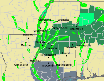
If we were expecting to stay dry for a while, I would confidently say that the worst will soon be over for residents of Jackson and the surrounding environs, however the forecast calls for more rain. Many parts of Mississippi, including Jackson, will see at least a couple more inches of rain through Thursday, leading the WFO in Jackson to pain the region in Flash Flood watches and warnings.

Mississippi’s terrain is porous and will be able to absorb the excess faster than many places, but it is still significant to see flash flooding forecast over such a broad swath of land. The next round of rain and thunderstorms has already popped up south of Grenada.
