This has been a weird month for me. It seems strange during this period in history to say I’ve been very busy, but those are the facts. You might not remember what west Texas was like back in the beginning of the month, but I can tell you that, unequivocally, San Angelo was hot, particularly on June 8th. That wasn’t a big surprise though. In fact, none of the hot, sunny weather was a surprise during our forecast period, as everyone came through with pretty good numbers. Nobody was better than Weatherbug, though, gaining a victory. Actuals: June 8th – High 104, Low 71 June 9th – High 96, Low 75
The tornado season in the southern Plains was a lot quieter than in recent years, and was quieter than normal in general. This is welcome news to all, certainly. We are through May, the peak of the season around Oklahoma City, and well into June, often the time of year things peak in the Upper Midwest. We had some derecho activity in the Black Hills and High Plains in recent weeks, with strong thunderstorms tied in with Cristobal closer to the Great Lakes, but the beginning of June hasn’t been terribly traumatic either.
Strong thunderstorms will be possible as long as there is heat and humidity, however the organization for a large scale tornado outbreak requires some clashing of air masses, which only happens when cold air can invade from Canada. This year, those incursions haven’t been as regular, and 90 degree temperatures seem to be here to say.
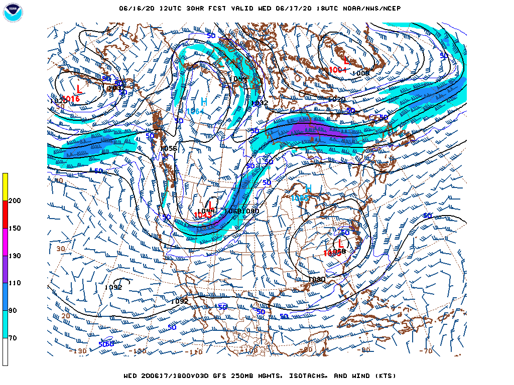
For posterity, here is a look at the last bit of a legitimate jet streak that we will see through the rest of the model output, and perhaps for several weeks. This map represents tomorrow morning.
It will create some severe weather in the Dakotas tomorrow, with a little bit of a cool down behind a cold front, but then, the jet and the cold air will reside comfortably in Canada and the Arctic.
There are a couple of Fayettevilles of note in this country of ours. For today, we will visit the North Carolinian version of the two.
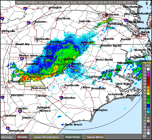
At 953PM, ET, Fayetteville was reporting overcast skies and a temperature of 76, with an incredibly sultry dew point of 73. The exhaustingly humid air was ahead of a line of storms extending from Raleigh to Norman and west towards Norwood, along which there were some severe gusts. These storms would likely inch into Fayetteville before the night was through. The wet weather is tied to a slowing cold front, associated with the remnants of Cristobal, who is now moving through Hudson Bay towards Baffin Island. This will lend to some lingering showers and storms in and around eastern North Carolina tomorrow, especially in the afternoon. Robust surface high pressure is moving in from the north, but an upper level trough is going to generate a surface perturbation that will ripple along the southern flank of the ridge, and will reinvigorate the threat for showers and storms in eastern North Carolina on Saturday. Unfortunately, that truly crisp air looks unlikely to make a lasting impression. Tomorrow – Isolated storms, otherwise muggy and mostly cloudy, High 83, Low 74 Saturday – Mostly cloudy, chances of rain and storms, High 83, Low 68
TWC: Tomorrow – Rain showers early with overcast skies later in the day. High 82, Low 70 Saturday – Sunshine and clouds mixed High 84, Low 64
AW: Tomorrow – A thick cloud cover and humid with a couple of showers and a heavy thunderstorm; watch for flooding High 83, Low 72 Saturday – Cloudy most of the time with a shower or heavy thunderstorm in the area; watch for flooding High 85, Low 67
NWS: Tomorrow – Scattered showers, with thunderstorms also possible after 11am. Mostly cloudy High 83, Low 72 Saturday – A chance of showers, with thunderstorms also possible after 2pm. Partly sunny High 84, Low 67
WB: Tomorrow – Cloudy with scattered showers with a slight chance of thunderstorms, High 81, Low 72 Saturday – Partly sunny. A chance of showers and thunderstorms in the afternoon, High 82, Low 67
WN: Tomorrow – Mostly cloudy with scattered showers, High 83, Low 71 Saturday – Partly cloudy with scattered showers, High 84, Low 67
FIO: Tomorrow – Rain in the morning. High 82, Low 71 Saturday – Partly cloudy throughout the day. High 82, Low 66
Some mixed messaging with the forecasts to round out the week. Rain? No? We’ll see! The radar for tonight continues to look active, though.
Jonesboro was a hot, dry place last weekend, which was more than could be said of the beginning of the work week. Cristobal tracked through the Lower Mississippi Valley, and brought oodles of rainfall to northeastern Arkansas. The weekend, as I noted, was hot and dry however. There had been a hint at some precipitation that never materialized on Saturday, which meant that Forecast.IO was able to claim a victory for the first forecast of June. Actuals: Saturday – High 92, Low 74 Sunday – High 94, Low 74
Right now, as I sit in my basement office, it is 87 degrees on the main floor of my house. Yes, we are having air conditioning issues. Will the week ahead have good temperature news?
College Station, Texas
Road Trip from Palm Coast, Florida to Oxnard, California
West Texas always provides for an interesting forecast in May. We’ve missed that month by a week. Does that mean we miss out on a particularly wild forecast? Let’s find out.
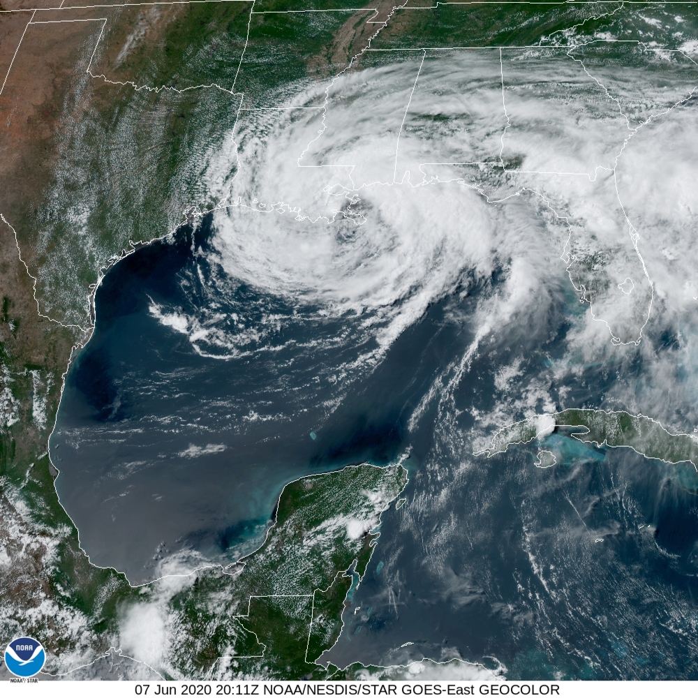
At 251PM CT, San Angelo was reporting a temperature of 96 degrees with clear skies. Tropical Storm Cristobal was moving ashore in eastern Louisiana, and while he wasn’t going to make a direct impact on west Texas, the redirected flow of moisture into the region, making skies even crisper. Cristobal is going to continue to move northward, while angling to the east, and will continue to leave west Texas in a drier regime, free of the threat of convection for the beginning of the workweek. An impulse moving out of the central Rockies on Tuesday will provide a shot of cooler air, and probably a threat of some gusty winds later in the day, but in the absence of moisture, thunderstorms are unlikely. Tomorrow – Sunny, High 104, Low 70 Tuesday – Partly cloudy, High 95, Low 72
TWC: Tomorrow – Mainly sunny. Near record high temperatures. High 105, Low 71 Tuesday – Sunny 98, Low 76
AW: Tomorrow – Sunny, High 106, Low 70 Tuesday – Breezy in the a.m.; otherwise, sunny and hot; caution advised if doing strenuous activities outside High 99, Low 73
NWS: Tomorrow – Sunny and hot, High 105, Low 72 Tuesday – Sunny and hot High 98, Low 74
WB: Tomorrow – Sunny, isolated thunderstorms in the afternoon, High 105, Low 71 Tuesday – Sunny, High 97. Low 75
WN: Tomorrow – Sunny, High 105, Low 71 Tuesday – Sunny, High 101, Low 74
FIO: Tomorrow – Clear throughout the day High 104, Low 70 Tuesday – Clear throughout the day. High 96, Low 72
Goodness gracious, is that hot. Typically, for a hot dry west Texas forecast, we don’t quite have this dramatic a satellite image. Here is Cristobal!
I was in Jonesboro in March last year, and though I only stopped briefly, I thought it was a neat little town. During March of tis year, a tornado went through town, setting it as an example of how cities would respond to severe weather during the pandemic, and Jonesboro passed with flying colors. Hopefully nothing as terrible this weekend!
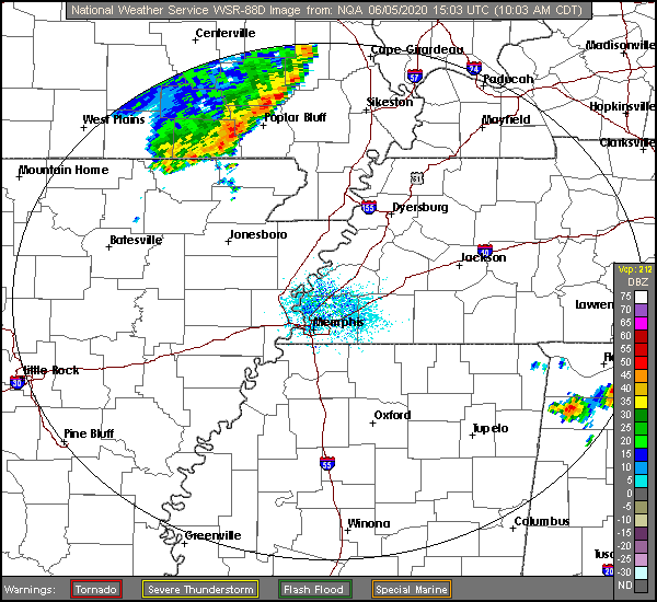
At 956AM, CT, Jonesboro Regional Airport missed it’s observation, however nearby Walnut Ridge was reporting fair skies with a temperature 83 degrees. A severe line of thunderstorms was moving through Corning, headed towards Marmaduke and Rector, and there was a chance for some shower activity this morning in Jonesboro. The thunderstorm activity is due to some local mesoscale forcing, it should be fairly quiet this afternoon. Jonesboro’s weather this weekend looks to be in response to two large features, a developing low in the high plains, and tropical storm Cristobal. General early summer convection will be snuffed out by Cristobal, but as low pressure emerges in Montana, moisture entrainment will be reinvigorated. A few showers and storms will be possible on Saturday afternoon as a result, but as Cristobal arrives along the Louisiana coast, moisture will be drawn away from town to conclude the weekend. Tomorrow – Mostly sunny, with an isolated shower or storm in the afternoon, High 94, Low 75 Sunday – Sunny and still quite warm, High 94, Low 75
TWC: Tomorrow – Generally sunny despite a few afternoon clouds. A stray afternoon thunderstorm is possible. High 95, Low 73 Sunday – Generally sunny despite a few afternoon clouds. High 94, Low 75
AW: Tomorrow – Partly sunny, warm and humid; a thunderstorm around in the afternoon High 94, Low 75 Sunday – Warm with sun and areas of high clouds High 94, Low 74
NWS: Tomorrow – A 20 percent chance of showers and thunderstorms after 2pm. Sunny, High 92, Low 71 Sunday – Sunny, High 91, Low 73
WB: Tomorrow – A 20 percent chance of showers and thunderstorms in the afternoon. Sunny, High 93, Low 76 Sunday – Sunny, High 83, Low 76
WN: Tomorrow – Partly cloudy with isolated storms, High 92, Low 72 Sunday – Mostly sunny, High 91, Low 73
FIO: Tomorrow – Humid throughout the day. High 95, Low 74 Sunday – Humid throughout the day. High 94, Low 75
Strange to see Weatherbug go warmer than the Weather Service. I went with a warmer Sunday than Saturday because of the clouds I expect on Saturday. The SPC issued a watch for this line as I was writing this post. Technically, Jonesboro is under a watch until 6pm, but I’m sure they will be cut out within a couple of hours.
The start of June was proceeding just fine on Monday, but then after a little warm front brought a scant amount of precipitation to Sandusky overnight, Tuesday was very different. Amid forecast highs that were supposed to be in the upper 70s to low 80s, opportune clear skies led to a high of 90. Nope, nobody was close. The Weather Channel had the top forecast, simply on the merits of having the warmest forecast on Tuesday. Actuals: Monday, Trace of rain, High 73, Low 50 Tuesday – .04 inches of rain, High 90, Low 59
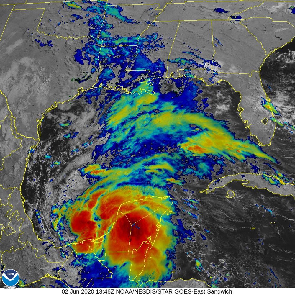
As we noted a couple of days ago, the tropics have been active very early this season, and now, it appears as though the Gulf of Mexico will offer up it’s first tropical storm of the season. Tropical Depression Three is churning in the Bay of Campeche, as seen here on satellite.
The circulation is just off shore, even as the primary area of convection is quite visibly over the Yucatan Peninsula. This is important, because this will allow the storm to continue to intensify. Models anticipate an intensification to a tropical storm — Cristobal — perhaps even this morning.
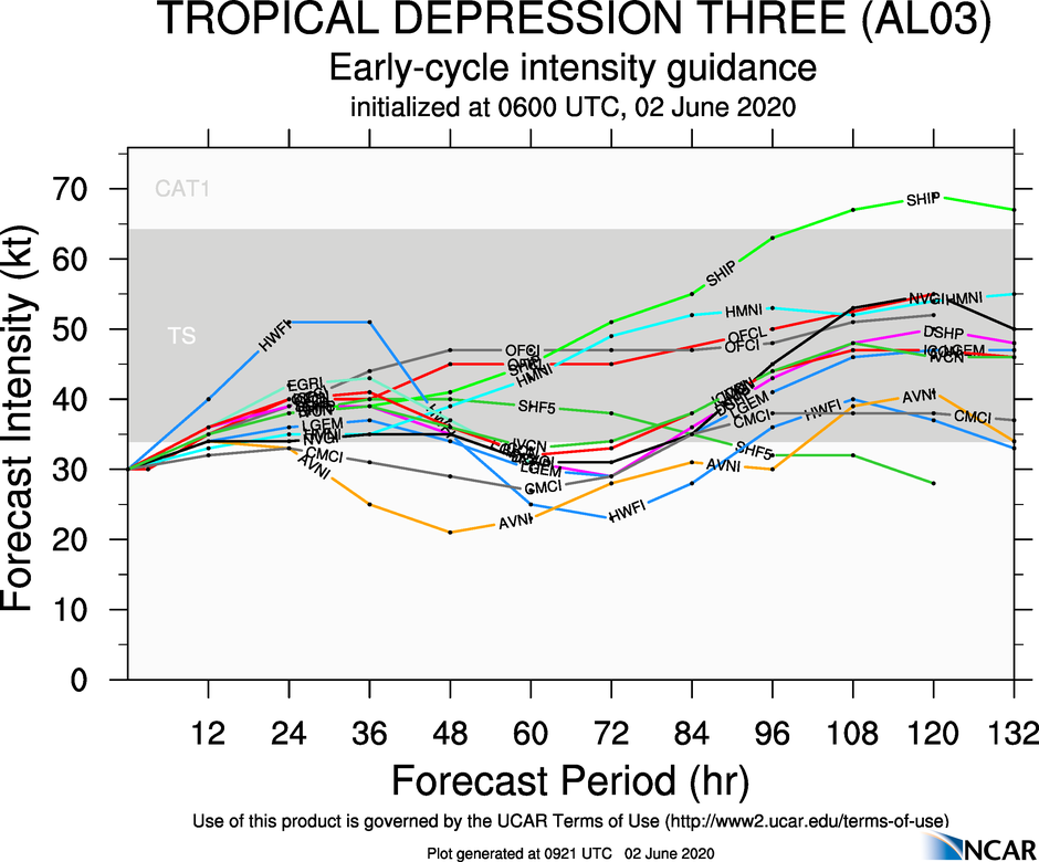
Spaghetti plots have a tendency to underestimate the peak intensity of tropical features, which means that I and many other outlets believe that this storm may even reach hurricane status as it drifts to the Gulf Coast.
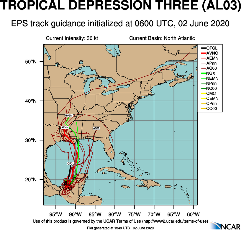
It’s still going to go through a period meandering through the Bay of Campeche before it starts to drift towards the Louisiana Bayous, which means there is still a great deal that is unknown. For the time being, this is what the forecast spaghetti plot looks like.
The potential for heavy rain will be the primary concern for coastal residents as the storm approaches, though wind and isolated tornadoes are always possible with tropical features.