Santa Rosa, California to Gadsden, Alabama

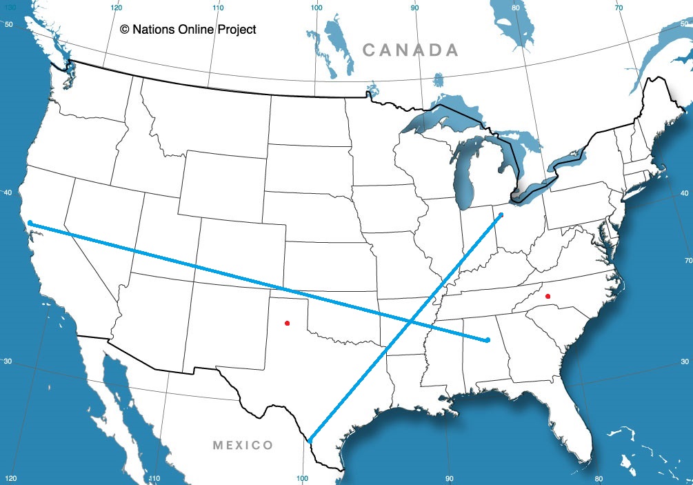
Let’s set forth on the open road this afternoon, and take a 4 day journey from California to the Southeast. The drive will cover four days, with the final day running very long. At that point, we will be inured to the long driving, though. That’s been my experience. It will be a 2,443 mile journey, paced at a blistering 69.8mph, which means we will cover 558.4 miles a day on those first few days.

DAY ONE (Sunday)

Santa Rosa, California By JLankford – wikitravel, Public Domain, https://commons.wikimedia.org/w/index.php?curid=37654846

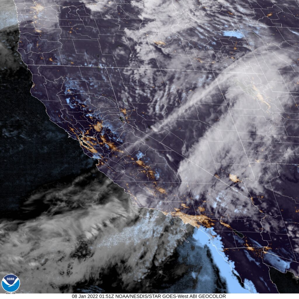
As is often the case with drives through California, the weather will be sunny and clear. High pressure in the Intermountain West is producing some gusty Santa Ana winds, so keep your hands on the wheel and be wary of high profile vehicles in other lanes. The drive will start taking us inland, but will mostly be a southward drive. We’ll end up at the Mohave National Preserve in southern California.

DAY TWO (Monday)
These will be good days to continue driving in the southwestern US. It will be the warmest part of cthe country, and will be ensconced in high pressure. A broad trough will be pushing south, but will remain well to our north on Monday. The wind may pick up as a result, but we will still be dry. The day will end on the west side of Albuquerque.

DAY THREE (Tuesday)
That trough I referenced from Monday will help in the generation of a system in the Gulf of Mexico. This isn’t pertinent to our driving conditions on Tuesday, but should indicate how much further the cold air will press south. It’s already chilly in the southern Plains, but it will be well below freezing, even in Midwest City, one of Oklahoma City’s eastern suburbs to finish the day, and it will be cold.

DAY FOUR (Wednesday)
The active weather will continue to be pressed further south, even, than our southern US route. Be wary of drivers from Oklahoma to Alabama, though, as they are not used to even the slightest bit of ice on the roadways. It’s going to be cold in Gadsden, and even I, a Minnesotan, is saying that.

Gadsden, Alabama

A strong start to the new year

The strong start in reference is definitely not a reference to the January posting consistency, but rather how well the National Weather Service handled a challenging forecast in Trenton to start the year. The first round of wet weather of the year slid up the east coast and brought a bit of early morning rain and eventually plummeting temperatures. The NWS threaded this treacherous needle getting only 1 degree of error, and having a proper temperature forecast. A solid start to the new year.
Actuals: January 2nd, .07 inches of rain, High 59, Low 35
January 3rd, High 34, Low 21

Grade: A- C

Santa Rosa, California

We are in the middle of January, and especially those of us on the East Coast are probably pining for some sunny California weather. of course, Santa Rosa is in the North Bay, so we may not be that fortunate.

At 653AM, PT, Santa Rosa was reporting a temperature of 37 degrees with clear skies. There were clouds and fog still lingering to the south over San Francisco and inland towards Modesto, and temperatures there were up to 10 degrees warmer.
There is a weak trough flow in California, which is allowing for the modest on shore flow, bringing enough moisture for some morning clouds and mist along the coast. The trough will strengthen inland over the next couple of days, however, models suggest a lingering coastal trough, perhaps pointing to offshore flow, breezy winds but generally clear skies through mid week.
Tomorrow – Morning clouds and haze possible, High 59, Low 37
Wednesday – Less cloudy and hazy in the morning, a little warmer, High 63, Low 38

TWC: Tomorrow – Partly cloudy, High 59, Low 39
Wednesday – A few clouds early, otherwise mostly sunny. High 63, Low 40

AW: Tomorrow – Times of clouds and sun High 58, Low 38
Wednesday – Partly sunny High 61, Low 40

NWS: Tomorrow – Areas of fog before 10am. Otherwise, mostly sunny, High 60, Low 41
Wednesday – Patchy fog before 10am. Otherwise, mostly sunny High 62, Low 40

WB: Tomorrow – Mostly cloudy in the morning, then becoming sunny. areas of fog in the morning. High 58, Low 44
Wednesday – Partly cloudy in the morning, then becoming sunny. High 61, Low 44

WN: Tomorrow – Partly cloudy, High 60, Low 41
Wednesday – Mostly sunny, High 62, Low 40

FIO: Tomorrow – Partly cloudy throughout the day. High 59, Low 42
Wednesday – Partly cloudy throughout the day. High 62, Low 41

Now, for an alternative take, here is KPIX’s Darren Peck with a look at the weather for the Bay Area.

The last look of the year

Just before we rolled into 2022, I put together a forecast for Erie, which turned out to be quite sodden. Sure, it was unusually warm for northeastern Pennsylvania as the new year arrived, but a cold front an a system coming out of the Ohio Valley conspired to make sure the warmth was wasted, and it rained for most of the first two days of the year. Temperatures continued to drop through the first two days of the year, and while it was in the mid-50s on New Years Day, it was merely 22 on the 2nd. This forecast, since it started on the 31st counts as the last of 2021, and gets awarded to Weatherbug. Fitting, given how many forecasts they won this year.
Actuals: Jan 1st, .48″ of rain, High 54, Low 37
Jan 2nd, .15″ of rain, High 37, Low 22

Grade: B-D

Coming soon…

Perhaps we have finally found our 2022 groove. We’ll check to see if that is the case as we put together forecasts across the country, with a couple of stops in Texas

Road Trip from Santa Rosa, California to Gadsden, Alabama

Amarillo, Texas

Hickory, North Carolina

Lima, Ohio
Road Trip from Laredo, Texas to Lima

Oxnard, California

As I get this post set up and prepped, I would like to note that it was -20 here at the Victoria-Weather offices today. It’s that attitude I get to take to this forecast for southern California.

At 551PM, PT, Oxnard was reporting a temperature of 55 degrees with overcast conditions. A large area of low pressure in the Pacific Northwest was influencing weather across the western US, with a stream of clouds, and some onshore flow over southern California. Oxnard had broken out a bit more than their counterparts to the south, as Los Angeles was also experiencing some early evening haze.
High pressure is going to build back in, but it won’t eliminate the near coastal moisture. Clouds will likely be problematic in higher terrain, but they will just momentarily blot the sun through the weekend in Oxnard. Expect the threat for fog to arise overnight, though not as significantly as will be found to the south. Off shore flow will ensure that the haze doesn’t linger during the day.
Tomorrow – Early haze, mostly cloudy, High 60, Low 50
Sunday – Mostly cloudy, High 67, Low 48

TWC: Tomorrow – Partly cloudy skies. High 59, Low 48
Sunday – Partly cloudy. Strong Santa Ana winds possible. High 67, Low 46

AW: Tomorrow – Clouds giving way to some sun and cool, High 59, Low 47
Sunday – Mostly sunny High 65, Low 47

NWS: Tomorrow – Patchy fog before 10am. Otherwise, partly sunny High 59, Low 46
Sunday – Mostly sunny, High 64, Low 45

WB: Tomorrow – Low clouds and fog in the morning, then sunny, High 60, Low 47
Sunday – Sunny in the morning, then partly cloudy, High 66, Low 48

WN: Tomorrow – Partly cloudy, High 60, Low 46
Sunday – Partly cloudy, High 65, Low 45

FIO: Tomorrow – Clear throughout the day. High 63, Low 49
Sunday – Partly cloudy throughout the day. High 70, Low 51

I’m going to really take a look at those winds on Sunday. I just don’t see it being that breezy in Oxnard. Satellite shows the mid layer clouds as well as a thatch of low clouds and haze south of the Oxnard area.

Erie, Pennsylvania to Trenton, New Jersey

Trenton is right on the border with Pennsylvania, but you couldn’t ask for a longer drive into the next state over. It will take a whopping 6 1/2 hours to cover the 435 miles across the Keystone state,. The pace will be 65mph, which seems faster than I anticipated. Road trip 2022!

Erie, Pennsylvania

A large juggernaut of low pressure is battering the mid-Atlantic today, getting perilously close to the Trenton area. Pennsylvania itself is under the grips of a chilly high pressure. The nice thing about big areas of organized low pressure is that they move, and do so swiftly more often than not. The low will be headed for Newfoundland by the time we awake tomorrow morning, and Trenton, just like the entirety of Pennsylvania, will be cold but sunny and dry.

Trenton, New Jersey

Trenton, New Jersey

Erie is going to go down as a 2021 forecast, so here it is, the first official forecast of 2022.

At 1153PM, ET, Trenton was reporting low clouds and rain, with a temperature of 53 degrees. S cold front over the eastern Great Lakes is being held up by a developing and active area of low pressure. The cold front is backed by a deep cold pool, and that conflict of air mass is helping the low in the Poconos to continue to strengthen. In the short term, this means rain for Trenton.
The initial feature will move towards the Canadian Maritimes, but the upper level dynamics in the region will remain unchanged. A deeper, stronger area of low pressure will emerge in the southeast while the cold front starts to sink towards Trenton. The cold air will arrive before the northeastward moving low pressure center, and as a result, snow is anticipated, at the very least to mix in on Monday, particularly around midday. This second feature is going to be stronger, windier as well as being more quickly moving. By the end of the day, it will be quite a bit clearer.
Tomorrow – Rain likely through much of the day, High 57, Low 36
Monday – Rain mixing to snow, clearing late, High 36, Low 25

TWC: Tomorrow – Overcast. Slight chance of a rain shower High 59, Low 37
Monday – Scattered snow flurries and snow showers before noon. Becoming partly cloudy later. High 36, Low 23

AW: Tomorrow – Considerable clouds and mild; a little morning rain followed by a passing shower this afternoon High 56, Low 35
Monday – Clouds giving way to some sun and much colder High 34, Low 24

NWS: Tomorrow – A chance of showers before 11am, then a chance of showers after noon. Patchy fog before 11am. Otherwise, cloudy, High 59, Low 35
Monday – Mostly sunny High 34, Low 22

WB: Tomorrow – Patchy fog in the morning. Cloudy with a 40 percent chance of showers, High 59, Low 37
Monday – Mostly sunny, High 37, Low 25

WN: Tomorrow – Mostly cloudy with light rain showers High 59, Low 36
Monday – Partly cloudy, High 36, Low 33

FIO: Tomorrow – Light rain overnight and in the morning. High 61, Low 35
Monday – Overcast throughout the day. High 36, Low 24

A bold move by other outlets keeping precipitation out of the picture entirely on Friday. Still, and especially with snow flurries, it tends to get everywhere. I don’t think anyone will cut precip out of the forecast on the coast in their forecast for Monday afternoon and evening. Here is all the rain around the region tonight.

nton

A very merry forecast

On Christmas Eve, while all the children were snug in their beds with sugar plums dancing in their heads, we were stirring with a forecast for Sebastian, Florida. It made me pine for the years I spend in Florida, as highs were near 80 on Christmas and the day after, with barely a cloud in the sky. With the way this month has gone, it nearly rates as a Christmas miracle, but Victoria-Weather had the top forecast for Sebastian.
Actuals: Saturday (Christmas), High 80, Low 53
Sunday – High 78, Low 53

Grade: A-C

Erie, Pennsylvania

We are starting the year as urgently as possible, as this forecast will post just as the day turns to 2022. Erie is right in the middle of the south shore of the lake that bears its name, and is susceptible to lake effect snow this time of year. Will Erie start 2022 on a snowy note?

At 1211AM, ET, Erie was reporting a temperature of 47 degrees with light rain. Heavier rain was falling between Erie and Buffalo than in either of those cities, but with temperatures warm enough even at this early hour, the threat for snow to accompany the rain can be ignored. A cold front lies through southern Ontario, helping to generate the few showers on the southeast side of Lake Erie, but a broad, distended area of low pressure stretches along the Ohio Valley, and is a focal point for more robust showers, with some thunderstorms on the south side of this feature.
For at least the next day or so, these two features will run in parallel. The low over the Ohio Valley will slide just to the south of the cold front, holding the boundary in place the whole while. As the Ohio Valley feature shifts into the Canadian Maritimes, the front will start to shift a little bit more to the southeast, bringing about colder air and a significant threat for snow, somewhat amplified by the Lake. After holding steady through the mid afternoon tomorrow, temperatures will get steadily colder, and are likely to be non standard through the weekend.
Tomorrow – Scattered showers, overcast, High 49, Low 42
Sunday – Early rain, followed by snow through the day, High 42, Low 27

TWC: Tomorrow – Showers early, becoming a steady rain later in the day. High 51, Low 38
Sunday – Snow during the morning will transition to snow showers during the afternoon. High 38, Low 25

AW: Tomorrow – A thick cloud cover and mild with a little rain; a wet start to the new year High 50, Low 38
Sunday – Rather cloudy and colder with snow showers, accumulating an inch or two High 39, Low 25

NWS: Tomorrow – A chance of showers before 2pm, then rain likely, mainly after 4pm. Cloudy, High 51, Low 40
Sunday – Rain and snow showers, becoming all snow after 11am. High 40, Low 27

WB: Tomorrow – Cloudy. Patchy fog in the morning. A chance of showers in the morning, then rain in the afternoon. High 50, Low 37
Sunday – Rain showers in the morning. Snow showers. Light snow accumulation. High 37, Low 25

WN: Tomorrow – Cloudy with light rain, High 51, Low 39
Sunday – Mostly cloudy with a light wintry mix, High 39, Low 32

FIO: Tomorrow – Rain until night, starting again in the afternoon. High 47, Low 36
Sunday – Possible light rain (with a chance of 1–2 in. of snow) overnight and in the morning. High 37, Low 22

WeatherNation with a rough start for the year, having the shortest hourly forecast. Of course, it is longer than it used to be, so their forecast is going to be better than we are accustomed to. Radar is most active northeast of Erie. Happy New Year!