It was a hot time in Pine Bluff on the 7th and 8th of the month. Of course, that is when we put together our forecast for the city, one that resulted in temperatures in the mid to upper 90s during the day, and temps that wouldn’t cool out of the mid 70s overnight. Uncomfortable, to be sure, but all outlets were pretty comfortable with each other’s forecast. There was a 4 way tie at the top, and only three degrees of difference separating top and bottom. It was The Weather Channel, Weather Service, WeatherNation and Clime all conglomerating at the top. Actuals: August 7th, High 94, Low 73 August 8th, High 97, Low 76
This drive has all the elements of what I think makes a good road trip. It will take one long day, following only a couple of interstates. There is one major metro area to drive through, but also a long stretch in the open country. It will take nearly 10 hours to cover the 658 miles between our two destinations, covering the ground at a pace of 66.2mph. Hopefully traffic in Dallas-Fort Worth is forgiving.
Pine Bluff, Arkansas
Arkansas is going to be downright juicy on Thursday. Humidity will see dew points in the mid to upper 70s, and while guidance suggests most of the rain and thunder will be from Mississippi eastward, I wouldn’t rule it out during our drive to Texarkana. In fact, I would venture to say that the heavy atmosphere might lend itself to a stray storm as far west as Mount Vernon, Texas. The dew points will relent a bit west of Dallas, but the heat will still be there all the way in to Midland.
Our forecast today is taking us to central Arkansas. It’s not quite the Ozarks, not quite the Mississippi Valley, it’s Pine Bluff!
At 753PM, CT, Pine Bluff was reporting a temperature of 84 degrees, with dew points in the low 70s. The high dew points were not enough to trigger isolated thunderstorms across the region, with a weak upper ridge nosing into the region, suppressing flow in any direction. Guidance is fairly consistent about lee troughing emerging as the week draws to an end. If anything, this will mean even more humidity, this time from the Gulf, rather than augmented by the woods of the Ozarks, and at all levels. While precipitation isn’t expected, there is an increased level of clouds by Friday. Tomorrow – Mostly sunny, high 91, Low 70 Friday – Partly cloudy, High 96, Low 71
TWC: Tomorrow – Sunshine. High 97, Low 71 Friday – Sunshine. High 98, Low 73
AW: Tomorrow – Mostly sunny High 96, Low 70 Friday – Plenty of sunshine High 96. Los 71
NWS: Tomorrow – Sunny, High 96, Low 71 Friday – Sunny and hot, High 97, Low 71
WB: Tomorrow – Sunny. High 94, Low 75 Friday – Sunny. High 92, Low 73
WN: Tomorrow – Mostly sunny, High 96, Low 71 Friday – Mostly sunny, High 97, Low 71
CLI: Tomorrow – Sunny, High 96, Low 71 Friday – Sunny, High 98, Low 72
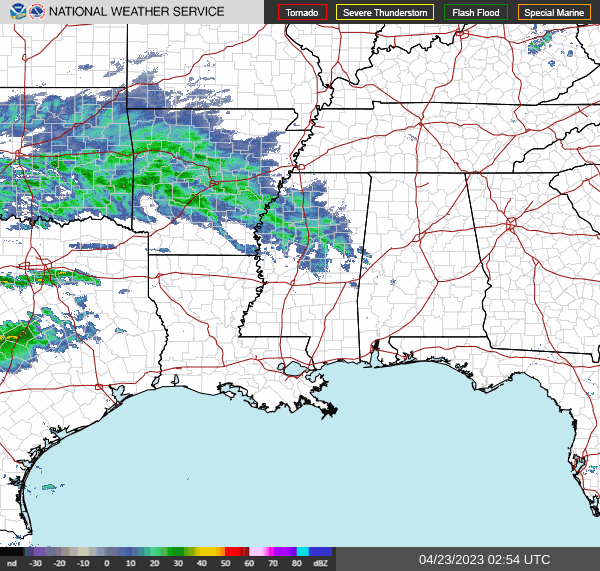
It looks fairly quiet on radar over Arkansas. Those storms aren’t going to be working north any time soon.
Pine Bluff was among the towns that endured severe weather this week, and as it happens, they are within a tornado watch in a Moderate Risk area again right now. When we put together a forecast there for the beginning of the week, it was the beginning of a needed 2 day interregnum. There was one more splash of rain before sunrise on Monday morning, but both Monday and Tuesday were relatively cool, and definite winners for fans of spring. Clime was also a winner, with a very good forecast, and the good sense to leave the chance of rain in the forecast for Monday, unlike some forecasters. I should note, Pine Bluff and the nearby environs did avoid the worst of the weather on Wednesday. It ended up initiating just to the northeast of the area Actuals: Monday – .08″ of rain, High 71, Low 54 Tuesday – High 76, Low 48
Arkansas doesn’t get thought about as a severe weather center, despite the location between both the original Tornado Alley and the Dixie Alley. It can be a stormy place, Arkansas, when March rolls around. It sure has been today.
At 953 PM, CT, Pine Bluff was reporting a temperature of 77 degrees with fair skies. Thunder was beginning to depart Arkansas, however the cold front hadn’t yet reached Pine Bluff. Little Rock’s dew point was dropping, and there were waning showers and isolated storms between Pine Bluff and the capital. The severe storms have moved out, however. After the boundary moves through, an initial pool of cooler air will spill in, and be reinforced by a shallow upper level ridge. This will scuttle a dramatic cooldown, and the next major storm developing in the Plains will kick off a warm up by mid week. Tomorrow – Clearing and cooler, High 70, Low 53 Tuesday – Mostly sunny, High 77, Low 45
TWC: Tomorrow – A mainly sunny sky (Early storms). High 71, Low 53 Tuesday – Partly cloudy skies. High 77, Low 46
AW: Tomorrow – Cooler and less humid with sunshine (early storms); High 71, Low 56 Tuesday – Sunny to partly cloudy and pleasant High 78, Low 47
NWS: Tomorrow – Mostly cloudy through mid morning, then gradual clearing (early storms) High 69, Low 53 Tuesday – Mostly sunny, High 77, Low 46
WB: Tomorrow – Sunny, (early rain) High 69, Low 59 Tuesday – Mostly sunny. High 76, Low 49
WN: Tomorrow – Mostly sunny (early storms), High 69, Low 55 Tuesday – Mostly sunny, High 75, Low 47
CLI: Tomorrow – Sunny (early rain) High 70, Low 54 Tuesday – Partly cloudy High 77, Low 48
My forecast counterparts all have a chance for more storms tonight, but it has really quieted in Arkansas (though a cell popped up near Stuttgart just as I finished). The roughest weather in Arkansas today was found up by Jonesboro and Memphis.
I think that there is fairly universal consensus that the best kind of weather is where highs are in the 60s – warm but not too hot- with plenty of sun. As it worked out, that is exactly the weather that Pine Bluff saw on April 24th. The 23rd was cooler with some rain, which made the 24th seem even better. It felt the best, perhaps, for the Weather Service and WeatherNation, who tied for the top forecast. Actuals: April 23rd: .03 inches of rain, High 57, Low 46 April 24th, High 66, Low 43
The historic snow in the northern United States this winter is leading to some significant flooding impacts, starting in Minnesota, but probably working downriver. Our route, less than a day between Alabama and Arkansas, covering 361 miles, cross the mighty Mississippi at Helena, Arkansas, where the River is already pretty wide, and the bridge is tall. Hopefully, that means the only worries we end up having are with the ongoing weather impacts, rather than the impacts of precipitation many months ago. We’ll pass by the Mississippi Valley at a meandering 60mph pace, which at this rate, might take us a full 15 minutes to drive over the bridge.
Birmingham, Alabama
If you find yourself living in any part of the United States’ contiguous states, you are probably experiencing or will soon experience, below normal temperatures. If not, you are probably on the West Coast, and this blog is probably not the first click in your morning surf. But the below normal weather in the east is the result of a stout area of high pressure extending from Canada all the way into the American Southeast. This will keep the drive through Alabama and Mississippi pretty tranquil. An area of low pressure is going to start emerging tonight and tomorrow in the Southern Plains and start to feast on moisture banked in Texas. A weak warm front will start sneaking north in Arkansas which could bring some late puffy cloudy to the Pine Bluff area. They aren’t likely to bring rain before our drive is over, but expect a wet middle to the week in Pine Bluff.
It’s time for a forecast in Arkansas. Arkansas finds itself between the Dixie Alley and the more traditional Tornado Alley in the high Plains, and sees it’s fair share of twisters. This is the time of year for them, but will that be the case this week?
At 953PM, CT, Pine Bluff was reporting a temperature of 61 degrees with overcast skies. Surface low pressure over the Great Lakes is dragging a cold front through northern Louisiana. A chilly north wind is blowing throughout Arkansas, and while much of the state is expected to cool significantly overnight, it will likely be slow to do so in Pine Bluff. A jet running parallel to the base of the trough is suspending the cold front, leaving clouds across southern Arkansas, and preventing radiational cooling. Amid the clouds are a few light rain showers streaming across Arkansas, but dropping dew points in the area are preventing all the rain seen on radar from reaching the ground. In the entrance area of the southern jet, there is going to be some disorganized shower and thunderstorm development. Onshore flow in the region will bring about enough moisture and potential energy for some rain and embedded thunderstorms across east Texas, with some activity spilling eastward. The best threat for rain will be on Sunday, wrapping up late in the evening. Monday should mostly be dry, but unseasonably cool. More clouds are expected to move in late on Monday. Tomorrow – Scattered showers ending in the late evening, High 55, Low 45 Monday – Mostly sunny, with clouds returning late, High 65, Low 40
TWC: Tomorrow – Cloudy skies (early rain). High 59, Low 46 Monday – Except for a few afternoon clouds, mainly sunny. High 69, Low 41
AW: Tomorrow – Cloudy and cooler High 59, Low 48 Monday – Mostly cloudy High 69, Low 43
NWS: Tomorrow – A 20 percent chance of rain before 9am. Mostly cloudy, High 58, Low 45 Monday – Mostly sunny, High 66, Low 42
WB: Tomorrow – Mostly cloudy. A chance of rain in the morning. High 68, Low 47 Monday – Mostly sunny, High 68, Low 43
WN: Tomorrow – Mostly cloudy with isolated showers, High 58, Low 45 Monday – Partly cloudy, High 66, Low 42
CLI: Tomorrow – Light rain showers, High 61, Low 45 Monday – Partly cloudy, High 66, Low 43
Model guidance is falling short of the blend and consensus temperature forecasts. We’ll see who is better, man or machine. Rain has moved into Pine Bluff since I started writing this forecast.