Spring Snowstorm Sadness

It was a picture-perfect day around here in the Twin Cities. Upper 60s, partly cloudy, a little on a breezy side but wasn’t awful. These are the beautiful spring days that we cherish around here.

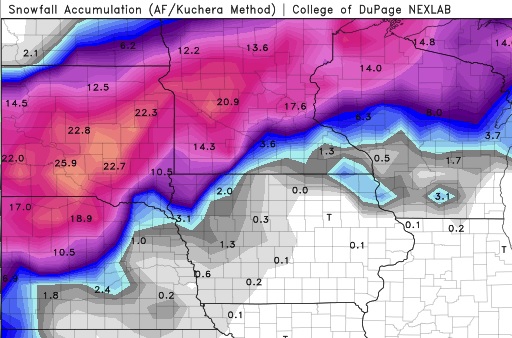
So of COURSE we’re looking at a monster snowstorm moving our way in 3-4 days. A low pressure system that’s currently moving onshore over the West Coast is expected to eject into the Plains on Wednesday and become another BOMB CYCLONE (it’s this year’s fun media-hyped weather buzzword, like Polar Vortex). Forecasts are, naturally, very wide-ranging in our area specifically, but it’s looking extremely likely that there will be a broad swath of land from western Nebraska to northern Minnesota that will get 12-18″ of snow, with embedded areas getting over 2 feet. Below is the latest GFS snowfall forecast through the event. It will be interesting to see how the system evolves over the next couple of days.

Just for reference, the biggest April snowstorm on record in the Twin Cities is 15.8″ set all the way back in… 2018. The 9th biggest storm of 9.0″ was also last year. This is not a trend I like to see continue, but alas, BUCKLE UP EVERYBODY. Winter is coming… well, I guess it hasn’t left at all.

Hattiesburg, Mississippi

After a quiet weekend, we are jumping back into the world of forecasting. Another big storm looms here in mid April, which is fine alongthe Gulf Coast, and might even be a little fun. Don’t ask about what it’s like up north.

At 753PM, CT, Hattiesburg was reporting a temperature of 72 degrees and overcast skies. Central Mississippi was seeing an active weather night, as a clearly evident vorticity maximum centered southeast of Brandon was drawing a band of thunderstorms along I-59, however the southern end was pulling northeast and away from town. The air in the southeast is juicy and unstable, but the trough parenting this hit of low pressure has little upper level support and a lot of forward momentum. Expect a quiet night in Hattiesburg.
And so it will be on Tuesday and Wednesday as upper level high pressure follows into Mississippi. Expect a brisk warm up on Wednesday as a beast of a system develops in the central Plains and taps into the Gulf of Mexico for moisture.
Tomorrow – Mostly sunny, High 77, Low 63
Wednesday – Partly cloudy, warmer and more humid, High 85, Low 57

TWC: Tomorrow – A shower or two around the area in the morning, then partly cloudy in the afternoon. Thunder possible High 80, Low 61
Wednesday- A mainly sunny sky. High 86, Low 55

AW: Tomorrow – A passing morning shower; otherwise, mostly cloudy High 79, Low 63
Wednesday – Plenty of sunshine; warmer High 86, Low 54

NWS: Tomorrow – A 20 percent chance of showers before 10am. Cloudy, then gradually becoming mostly sunny, High 81, Low 62
Wednesday – Sunny High 84, Low 56

WB: Tomorrow – Mostly cloudy with a 20 percent chance of showers in the morning High 78, Low 63
Wednesday – Sunny, high 85, Low 55

WN: Tomorrow – Partly cloudy with isolated showers, High 81, Low 62
Wednesday – Sunny, High 84, Low 56

FIO: Tomorrow – Mostly cloudy until afternoon. High 80, Low 63
Wednesday – Clear throughout the day. High 86, Low 56

First, check out the radar, and the low pressure evident even on this map.

Now let’s check in with WJTV from Mississippi for the Pine Belt forecast.

Storm Shadow

The Shenandoah Valley was far enough inland that the storm system that scooted up the coast early last week didn’t bring any precipitation to Harrisonburg on Tuesday. Residents of Harrisonburg did not get to enjoy any downsloping, however, and even without the rain, the cool north Atlantic breeze suppressed afternoon highs, and Monday and Tuesday couldn’t even reach the 50s. This combination of events allowed Victoria-Weather and Accuweather to split honors.
Actuals: Monday – High 46, low 24
Tuesday – High 45, Low 25

Grade:

Monroe, Michigan

It’s a rough time for basketball fans in Michigan. Michigan State lost tonight, while Michigan lost last weekend, and both to the same team, Texas Tech. Perhaps they will cope quickly. Does Monroe have the forecast for recuperation?

At 1253AM, ET, Monroe was reporting a temperature of 46 degrees with clear sites. Dew points were also at 46, and with haze filtering in around Ann Arbor, it seems as though the morning will be hazy in Monroe. Low pressure is developing in the Plains, with a warm front already arcing through northern Michigan. Warm, moist air was spilling into the eastern Great Lakes.
Low pressure will reach Michigan by this afternoon, with some rain and isolated thunderstorm activity joining it. The parent trough has been fairly shallow and is expected to move quickly across the northern US. The precipitation will ultimately punch through the region in the afternoon and evening and be out of the picture by Monday morning. It will be cooler to start the work week, but the responsible trough will be shallow enough that cold air won’t be overwhelming.
Tomorrow – Rain with a bit of thunder in the afternoon, High 63, Low 46
Monday – Clearing through mid morning, and warmer, High 68, Low 53

TWC: Tomorrow – Cloudy early with showers for the afternoon hours. Thunder possible. High 58, Low 41
Monday – Cloudy early with partial sunshine expected late. High 67, Low 52

AW: Tomorrow – Increasing cloudiness, mild; spotty afternoon showers High 62, Low 45
Monday – Clouds giving way to some sun; warm High 69, Low 54

NWS: Tomorrow – A chance of showers after 2pm. Mostly cloudy, Hgh 65, Low 45
Monday – Mostly sunny, (Early rain) High 68, Low 5

WB: Tomorrow – Mostly cloudy. Slight chance of rain in the morning, then rain showers likely and slight chance of thunderstorms in the afternoon. High 64, Low 43
Monday – Mostly sunny, High 68, low 55

WN: Tomorrow – Mostly cloudy with isolated storms, High 65, Low 44
Monday – Partly cloudy with isolated showers, High 68, Low 50

FIO: Tomorrow – Light rain in the evening. High 60, Low 40
Monday – Mostly cloudy until night. High 64, Low 51

Satellite has some clouds to the southwest. That’s the rain coming later today.

NOAA/NESDIS/STAR GOES ABI BAND 11 OR_ABI-L1b-RadC-M6C11_G16_s20190970551218_e20190970553591_c20190970554048.nc

March Forecaster of the Month

We were very busy in March. Even despite our complete website collapse, we fit 11 forecasts in, so we definitely feel comfortable in saying that The Weather Channel did enough to prove that they were the forecaster of the Month. It’s even more impressive than that, as they had 4.5 wins in March alone, and went from the lowest forecast win total for the year to the lead. Nice work, Weather Channel!

OutletMonth wins
The Weather Channel4.5
Victoria-Weather2
WeatherNation2
National Weather Service1.5
Accuweather1
Weatherbug
Forecast.io
OutletMonth winsyear wins
The Weather Channel4.55.75
Victoria-Weather25
Weatherbug4.58
National Weather Service1.53.75
WeatherNation23.58
Forecast.io3
Accuweather12.33

The opening salvo

We’re looking at a pretty active week in New England, and it ended with a bit of inclement weather last week as well. An area of low pressure slashed through New England and brought wind and rain to the region on Thursday and Friday, including in Worcester, where we had stopped in for a forecast. Things remained much cooler than in the forecast as a slow moving cold front proved inhibiting to solar radiation. Victoria-Weather was one of the handful of outlets that correctly called for rain (and they got .14″ which isn’t anything to sneeze at) and we also happened to be on the cool side of forecasters. Those two factors were enough to secure victory.
Actuals: Thursday, High 50, Low 25
Friday – .14 inches of rain, High 51, Low 38

Grade: B-D

Harrisonburg, Virginia

We’re taking our situation to the lee side of the Appalachians. It doesn’t seem like a heavily populated area, but there are many small cities from Winchester in the north to Charlottesville, Roanoke and Blacksburg with Harrisonburg in the middle.

At 935PM, ET, Harrisonburg was reporting a temperature of 37 degrees with clear skies. There was a brisk flow off the mountains, with some overcast over West Virginia, but it was chasing low pressure that had shifted off shore.
The area of low pressure over the Canadian Maritimes that was trailing the cold front was parented by a trough with a tail into the Great Lakes, however the jet had dug all the way to the Gulf of Mexico. Low pressure will develop at the base of the trough and move up the Gulf Stream. It will remain well off shore, and high pressure will remain in place over Harrisonburg, but the reinvigorated flow will keep Harrisonburg dry and cool to start the week.
Tomorrow – Mostly sunny, High 51, Low 25
Tuesday – Increasing clouds, High 52, Low 25

TWC: Sunny, along with a few afternoon clouds High 50, Low 26
Tuesday – Cloudy. High 50, Low 28

AW: Tomorrow – Plenty of sun high 50, Low 27
Tuesday – Some sunshine giving way to clouds High 50, Low 26

NWS: Tomorrow – Sunny, High 48, Low 25
Tuesday – A slight chance of rain after 2pm. Partly sunny, High 51. Low 29

WB: Tomorrow – Sunny, High 49, Low 30
Tuesday – Mostly sunny in the morning then becoming mostly cloudy, High 48, Low 31

WN: Tomorrow – Sunny, High 48, Low 25
Tuesday – Partly cloudy with isolated showers, High 51, Low 29

FIO: Tomorrow – Partly cloudy starting in the afternoon. High 52, Low 32
Tuesday – Mostly cloudy throughout the day. High 49, Low 32

The Weather Service and WeatherNation are leaning into the NAM today, but everyone else is a bit more optimistic. Satellite tonight shows off a pretty clear night in Virginia.

Modesto gives us all problems

There were two problems with the verification for Modesto. First, the airport on the south end of town didn’t properly maintain their records. Second, if they had, I’m not sure we would have been terribly successful. Temperatures generally ran much cooler than we had expected in the overnight hours. Maybe they would have been warmer at the proper airport, but I’m not really convinced. The temperatures were just too far off. We can still crown a winner, though, and we will. Accuweather had the top forecast for the day.
Actuals: Wednesday .02 inches of rain, High 69, Low 47
Thursday – .08 inches of rain, High 66, Low 41

Grade, C-D

West Virginia Warm up

See, we’re definitely back! Now we even have the alliterative verification titles and everything. This is certainly a fitting one for Morgantown, where temperatures reached a balmy 65 degrees yesterday, and without any of the rain that had been a potential. The springtime warmth comforted The Weather Channel, especially, as they claimed victory.
Actuals: Wednesday – High 60, Low 23
Thursday – High 65, low 39

Grade: B-C

Can flooding be slowed?

There are two things that we can see long term that help indicate whether or not flooding is in the future. Is there a lot of snowpack ready to melt? This year, that was a firm yes. Second, is there flooding upstream? For places from Missouri south to the Gulf of Mexico, the answer is also yes. Residents are already preparing, especially on the banks of the Missouri River.

A short term impact on flooding, as in one that can arrive with much less advance warning, is rain. Flash flooding is the result of more local rains, but river flooding can be exasperated by fresh rain fall. It can also be advanced by a rapid warm up, especially if coupled with rain. This was the problem in South Dakota, Iowa and Nebraska earlier this month.

Fortunately for millions of residents, the thaw at the headwaters of the Mississippi was methodical, with refreezing overnight, and a more tempered warm up. The Mississippi and many of it’s tributaries are high, but municipalities in Minnesota and Iowa were able to anticipate the rising waters, for the most part, and have been able to stave off major issues.

And although the CPC continues to have a wetter than average beginning to April and spring season in the forecast, the ground is beginning to thaw and most of the melting above ground is complete. The Mississippi is cresting in Minnesota and starting to recede, with a major crisis averted. The good news in Nebraska, Iowa Kansas and Missouri is that any potential catastrophes aren’t going to loom more ominous than they already do.

The water was so high upstream in Nebraska and South Dakota that downstream flooding through Kansas City couldn’t be averted (though it wasn’t as bad as feared) and communities between Kansas City and St. Louis will need to be aware too, however the graciousness of Mother Nature, allaying the melting process and keeping the Midwest dry for several days, and the lower Mississippi Valley can breathe a sigh of relief.