It is absolutely a credit to the meteorological community that we are now 7 months into the year, and we still have at least 4 outlets that are legitimate contenders for the Forecaster of the year title, with a 5th not far off the pace. On the strength of a strong summer, and another winning month in July, Accuweather has ensured that they are not to be forgotten, keeping pace with Weatherbug, The Weather Channel and Victoria-Weather. The National Weather Service was second, and showed that they aren’t out of this race yet either. Congratulations to Accuweather!
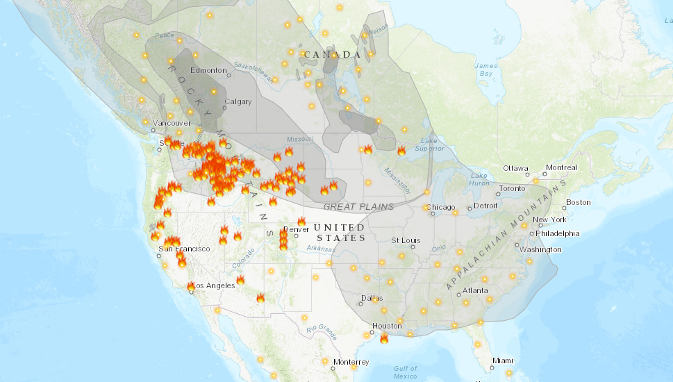
Another summer and we are plagued by wildfires. If there is any difference between this year and the last couple, it is that the bulk of the fire activity is in the northern Rockies, as well as in Alaska, rather than within the state of California. Surely, this is some relief to relatives of the Golden State, and it is definitely a good thing that the fire threat isn’t as imminent to as many people, however it is a burden for the rest of the country.
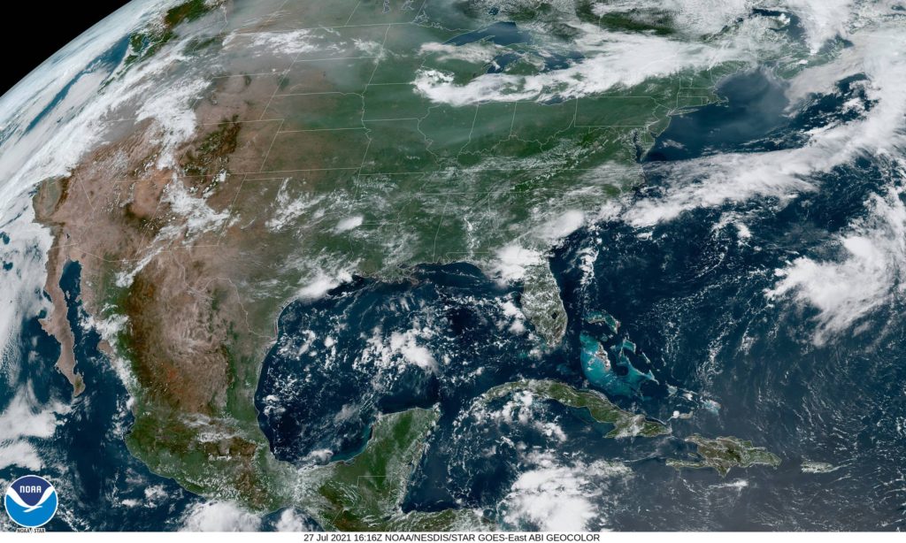
As this map, from Airnow.gov shows, there is smoke in the air for about 3/4th of the country. Air quality is below normal for all of those locations.
It is rare that the jet intercepts California during the summer, and it isn’t often that smoke can blanket the country as it is right now during a typical fire season. Also frustrating for many of the people getting smoked out right now, is that the flow bringing the smoke in is from the northwest. Were there no fires in the Pacific Northwest and particularly Alaska, the air would be cool and refreshing after a very hot month of July.
Smoke advisories continue to get extended for the region, as relief is not yet right around the corner. Fires, of course, need to be extinguished, but a more immediate source of relief would be a change in the prevailing pattern, but unfortunately, even that doesn’t look to change until at least late in the week.
In many summers, I find myself rolling my eyes at other outlets’ analyses of the surface. There is often a stationary boundary, left for days along the Gulf Coast of the US. Perhaps a cold front had descended from the Ohio Valley a week prior, but eventually, you need to call a spade a spade. There is onshore flow, and it causes thunderstorms. Not every boundary is a cold front.
This year, and especially right now, we haven’t been seeing those straggler boundaries populating the coast. Right now, it’s evident that there is an off shore boundary pointing into the Carolinas
One might be inclined to analyze something along the band of thunderstorms through north Florida, or perhaps even further north on the clearing line from southern Kentucky to central Oklahoma. In fact, most outlets are keeping truncated fronts, and there is a very good reason for that.
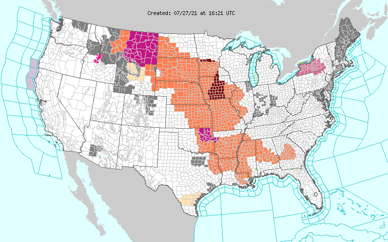
All of those orange and red shades are heat advisories. It is astonishingly hot throughout the Plains and Mississippi Valley. It’s really hard to say there is a cold front when there is a heat wave immediately behind the boundary. The WPC, proponent of the long ranging front, parlays the cold front into a warm front hugging those advisories to the west.
The jet is still somewhat active, but it remains well north of the domestic US. A cooler start to July in the southeast and a blistering start in the north is also starting to level off, but is making for a challenging environment for cold fronts to survive. If a change occurs, it will have to come from the west, which may happen next week.
The United States is experiencing it’s own catastrophes this year. Growing wildfires and drought in the west, with flash floods in the southeast, along with heatwaves in the north. A lot of the worst weather in the world seems to afflict the United States in an outsized fashion, but it seems that is not the case in recent weeks.
First is the story of flooding in central Europe. Relentless and heavy rains have been hammering Benelux and western Germany, leading to river flooding on the Rhine in Germany and the Meuse in Belgium in particular, with subsidiaries an other rivers also spilling out of their banks. The intensity of the rains also led to flash flooding in these areas, while the river flooding is continuing to disrupt lives, with the threat of disease adding onto threats to infrastructure and livelihood.
The flooding was the result of a stalled, training pattern of showers and thunderstorms that lasted for the better part of last week. The good news is that the flooding is going to be allowed to abate over the next week, at least. High pressure over the British Isles is going to drift toward the Low Countries and barricade them from additional rainfall for the week. The next real threat for showers and thunderstorms is next weekend, and we can all hope that the feature moves as quickly as the models presently suggest.
A bit closer to home, tornadoes are in the news. The US has had an incredible string of good fortune, in that there were no tornadoes stronger than EF2 in May or June. Unfortunately, in Barrie, Canada, the tornado news was worse. A tornado – measuring at an EF2 – struck residential parts of the community, taking roofs off of houses, but fortunately, doing structural damage and sparing the residents of the houses it hit.
Listen to the tale of Natalie Harris, a City Councilor in Barrie, who saw significant damage to her home during the twister on Thursday.
The greatest damage was to the far southeastern part of town. The damage would surely have been more significant if it had been just a couple miles to the north.
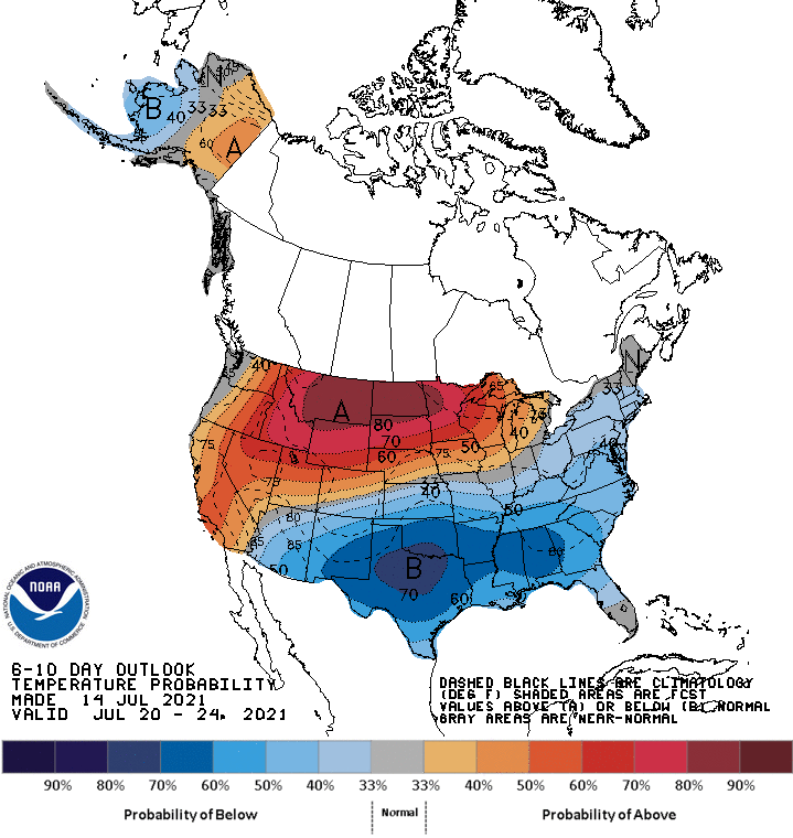
Another massive heat wave is in the forecast according to the CPC’s outlook, and this time, the region expected to be baked is the northern Plains and Upper Midwest. Curiously, while the northern US roasts, the southern part of the country looks to be well below normal. In the summer, that’s comfortable, so it’s not the story,
Unlike the blocking ridge that brought the heat in the Pacific Northwest last month, this looks like a more traditional ridge allowing all that heat to build. Temperatures from Montana through the Dakotas and into northern Minnesota could hit triple digits through early next week.
There will be a remnant mid and upper level trough over the southern US, which will lead to several rainy days, and keep temperatures cool. If it weren’t for that trough, given the greater jet pattern, a more significant heat wave could have been in store for a bigger population.
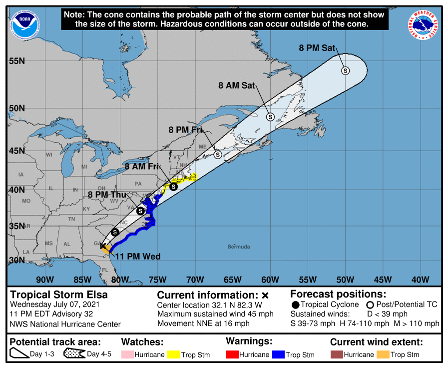
We have already reached the 5th named storm of the tropical season, but Elsa, the former hurricane presently drifting through the southeastern United States is the first hurricane of the season, as well as the strongest storm to make landfall this year.
Elsa’s strongest appearance on land, at least in terms of wind, was last night in Key West, when the airport reported a winds approaching 50mph. The primary threat from Elsa, as with most tropical storms, was, and continues to be, heavy rain.
Flash flood advisories were out for northern Florida and south Georgia, and have now shifted to South Carolina. There were also a few isolated tornado reports, and as Elsa spins northeast, there is a tornado watch for South Carolina and surrounding areas.
Elsa has been a mild storm, so read this as a precautionary tale. It still brought flooding, strong winds and tornadoes inland. Had she taken a different course, there may he been noteworthy storm surge as well, but her path, along the course and inland in a low density part of Florida, was beneficial for local residents. All tropical storms are dangerous, including Elsa, who isn’t quite done yet. Check out the forecast for the next few days.
There is still significant weather coming for the East Coast from Elsa. There are no other areas of concern in the Atlantic, but that will change, and we will then need to continue our maritime vigilance.
We are now halfway through the year, and have now clearly defined a best forecaster so far this year. After a three way tie through May, Weatherbug had the best month in June, and Victoria-Weather and The Weather Channel did not, giving them the lead as we head into the dog days of summer. Hurricane season and record breaking heat are around the corner, and meteorologists are surely around the corner, so continued forecast vigilance will be necessary.
The pattern across the country has once again stalled, and it is going to have dangerous effects in the Pacific Northwest. A severely tilted trough is holding up traffic across the country. A weakening system in the middle of the country is being propped up by a severely tilted trough, which in turn is blocking a ridge wrapping in from the west.
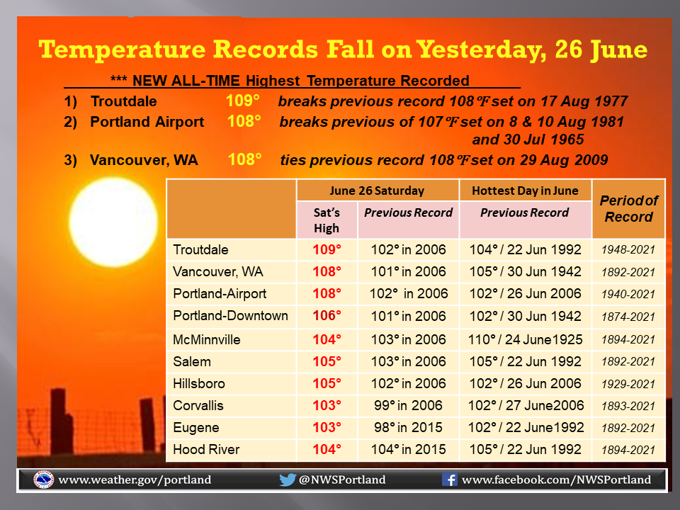
The strength of the ridge, and the continued entrenchment of the ridge are pushing temperatures to record totals. Not just for the day, or the month, but all time. Check out some of the totals from the Portland weather service office so far.
The trough is continuing to weaken in the middle of the country, which should allow the ridge out west to break down and start propagating to the east. Temperatures in Portland, which are, at the moment, sitting at 111, will start dropping after Monday, which will again hit well into the triple digits.
The summer, in particular the next few weeks, look like they will be above normal, however fortunately, the record breaking heat looks to be near it’s end. Without this particular wave to focus on, the attention will be turned to the persistent drought still smothering the west coast, and is being worsened in parts of the Pacific Northwest, no thanks to the inferno.
I am presently enjoying a vacation with my extended family in the Black Hills of western South Dakota, and we’ve had a bit of active weather in the last couple of nights. Tonight, we were in a severe thunderstorm watch, as a line of thunderstorms swept in from Wyoming and brought rain and marble sized hail to our cabin before getting a boost from the eastern slope of the Black Hills, and accelerated through Rapid City and is now preparing for a voyage through the Plains.
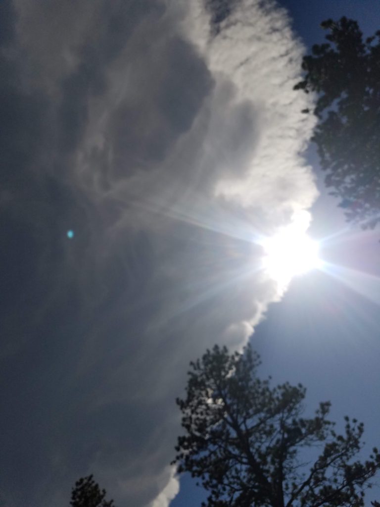
Last night, however, was different. An isolated thunderstorm, aided in part by the very mountain we are staying on, cropped up and stayed in the same spot for well over an hour. Here is the view from just to the north of the storm.
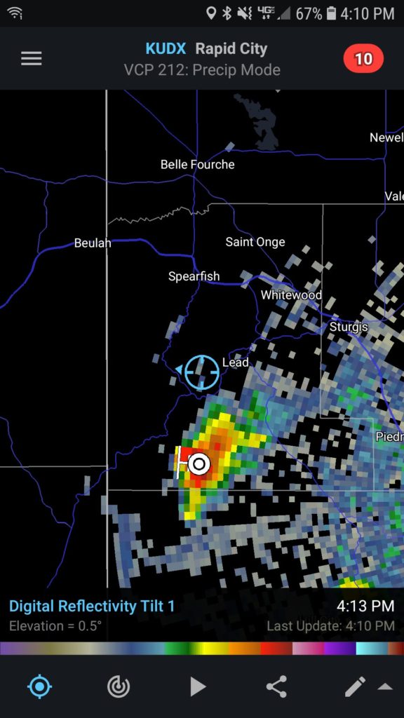
We were almost directly under this storm, and the radar confirmed our suspicions.
The storm did eventually expand and bring some drops of rain, but not as much as points on other faces of the mountain!
It was an interesting thing to see in action, the force of the terrain, and the structure of the storm that produced all of the wet weather to other parts of the mountain was pretty incredible.
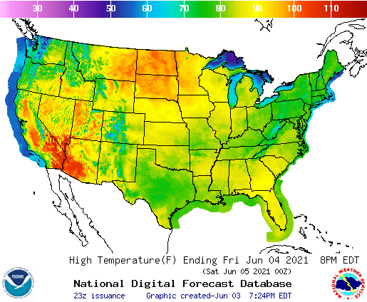
It was 90 degrees in Minneapolis today, which is certainly a pretty warm start to June, and tomorrow and the weekend will only get hotter. Heat waves are certainly newsmakers, and in particular, they are big news when they arrive in the northern US. All this is true, and really, it’s not the most interesting part of this particular heat wave. Take a look at the forecast highs for Friday.
There is the typical hot spot in the Mojave, but otherwise, the warmest part of the country will be…. North Dakota? The interesting part of this heat wave, to me, is that it completely bypasses places to the south. The forecast high in Bismarck tomorrow is 101! Unintuitively, the forecast high in Austin tomorrow is 80, a full 20 degrees cooler. I don’t have to tell you this, but that’s not how it usually works!
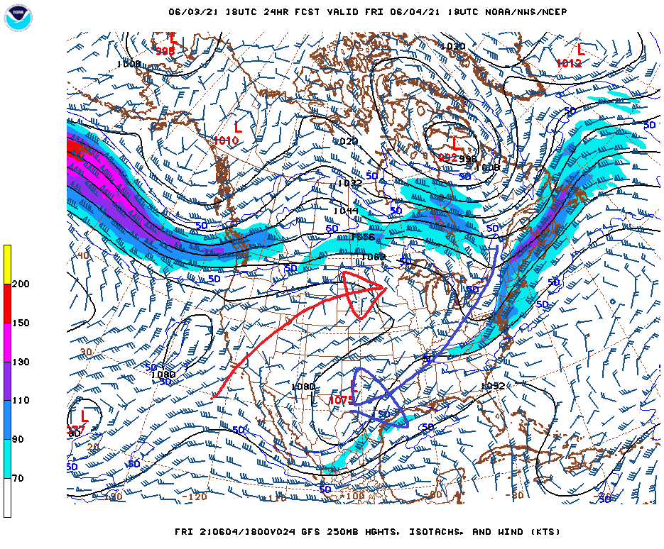
Why is this going on? The answer is told in the upper air forecast. Take a look at the flow pattern forecast during the day tomorrow. I have added some arrows for your benefit.
The pattern over the US is tilted. The upper level trough over the eastern part of the US takes a westward turn and heads through the southern Plains. Forgive me, because the axis of the trough in the south is a little further north than I drew it, but the result is the same. Moisture is being drawn to the Red River Valley, and then it streams into the eastern Great Lakes, keeping the entire tract covered in clouds and rain.
Meanwhile, a ridge axis runs from the southwest towards the Upper Mississippi Valley. Remember how I noted how hot it was in the southwest? Well, that is where the air moving into the Dakotas is coming from. Combined with the scouring effect of the Rockies, the dry air can warm even more during full daylight.
When this pattern sorts itself out, the hot air won’t go anywhere, but instead of shipping off to the northeast, the moisture entering through Texas will find a route north. Until a cold front comes late next week, the heat of this weekend will become hot and humid.
It’s only June 3rd. and the summer is off to a hot, hot start in the Northern Plains.