We have taken a bit of a hiatus this past week thanks to illness sweeping through the family, but we are back! Speaking of unwanted things sweeping through an area, let’s talk about Dubuque last week. Monday and Tuesday were hot days, and correctly forecast as such, but then, an interesting thing happened on Tuesday. Some outlets had thunderstorms on Tuesday, and some did not. The storms indeed showed up, but those stormy forecasters thought they would be fueled by hotter temperatures, which was not the case. Generally speaking, the best temperature forecasts belonged to those that kept Dubuque dry, but Weatherbug surpassed other outlets by having the best temperature forecast of outlets that forecast rain. It’s fitting that Weatherbug will claim victory, as the storms they successfully forecast for actually produced some severe weather in Eastern Iowa, and 55mph wind gusts in Dubuque. Actuals: Monday, June 20 – High 91, Low 61 Tuesday – .1 inches of rain in thunderstorms, High 95, Low 70
There is a well populated corridor on the Atlantic slope of the Appalachians, stretching from Virginia to the Carolinas. In Virginia, the largest of those towns is Roanoke, where we will forecast today.
At 1254PM, ET, Roanoke was reporting a temperature of 85 degrees with mostly cloudy skies. A trough was weakening, but still lingered over the east coast. An area of surface low pressure which had been responsible for copious rain in the region through the middle of the week was now off shore, being drawn northward towards the mean flow. Extensive clouds with some isolated showers were being seen in southeastern Virginia, but in the west, scattered cumulus were seen, with a ribbed pattern on radar reflecting gravity waves and brisk flow through the clouds. The clearer air to the west isn’t embodied by a particularly strong air mass, and Roanoke’s position in the lee of the Appalachians opens the possibility of low level moisture leading to morning haze, and the languid retreat of low pressure off shore may indicate some mid level clouds. It won’t be a vividly bright couple of days, but there is definitely enough here to believe that two dry days are ahead. Tomorrow – Morning haze, then partly cloudy, High 88, Low 67 Saturday – Partly cloudy, High 88, Low 67
TWC: Tomorrow – Partly cloudy, High 88, Low 67 Saturday – Partly cloudy, High 88, Low 67
AW: Tomorrow – Mostly sunny High 86, Low 68 Saturday – Partly sunny and humid with a thunderstorm High 87, Low 68
NWS: Tomorrow – Patchy fog before 9am. Otherwise, mostly cloudy, then gradually becoming sunny, High 87, Low 65 Saturday – A slight chance of showers and thunderstorms after 3pm. Mostly sunny, High 89, Low 67
WB: Tomorrow – Patchy fog in the morning. Mostly sunny, High 85, Low 69 Saturday – Mostly sunny. A slight chance of showers and thunderstorms in the afternoon, High 86, Low 69
WN: Tomorrow – Partly cloudy, High 87, low 65 Saturday – Mostly sunny, High 89, low 66
FIO: Tomorrow – Partly cloudy throughout the day. High 88, Low 65 Saturday – Partly cloudy throughout the day. High 88, Low 65
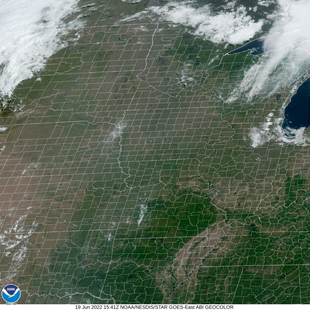
The threat for thunderstorms is so low, I was surprised to see it start showing up in some forecasts. A lot of texture to the clouds ongoing in the area.
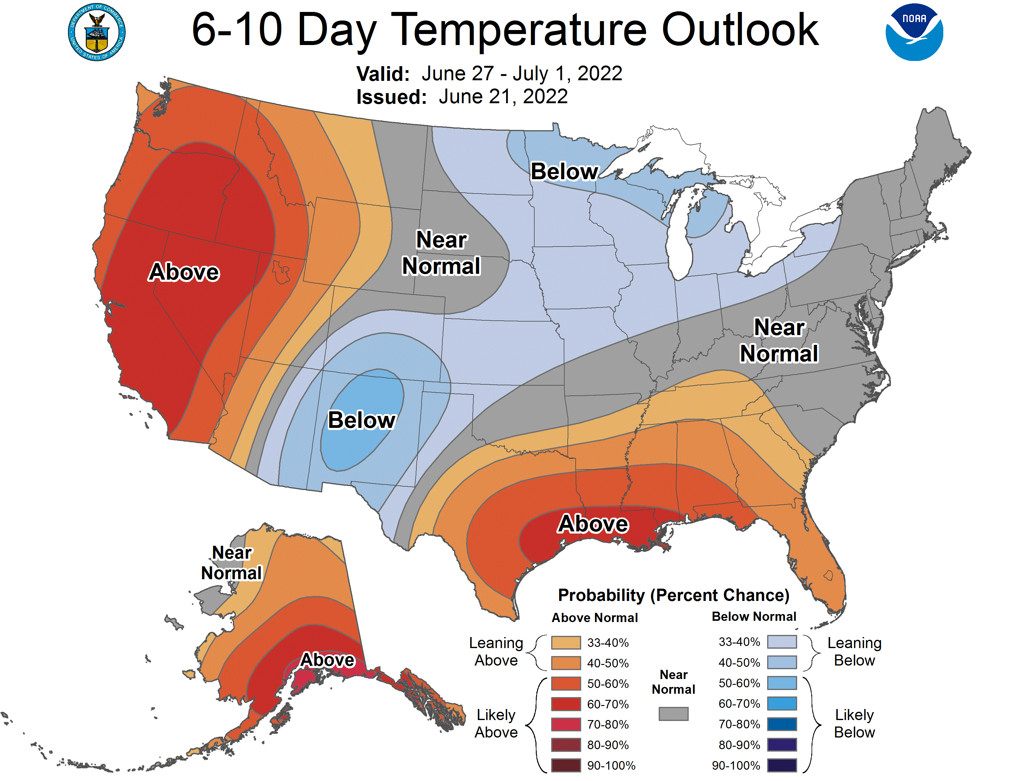
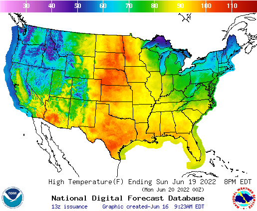
Everything being relative, of course, there was a rare sight on the CPC page. The Desert Southwest, particularly Arizona and fire ravaged New Mexico are expected to see below normal temperatures and above normal precipitation next week. This qualifies as good news, if it dents the drought and doesn’t fully inundate the region.
A combination of factors will lead to this tandem of potential results. First, the monsoon is expected to get a bit more active this week, producing thunderstorms across the southern Rockies between Arizona and New Mexico. Tropical Storm Celia is spinning off the coast of Mexico. It poses no threat to land, but will generate mid level moisture accessible by the air mass over the Land of Enchantment.
Second, an area of low pressure moving through the Northern US is going to leave a stationary front across the Plains, which is going to connect with the dry line and monsoonal flow in New Mexico and Arizona. Robust shower and thunderstorm activity is anticipated throughout much of the week.
Lightning is a threat to fire prone parts of the landscape, and dust will be a concern. Any heavy rain, especially in the undulating terrain could lead to flash floods. Despite these individual perils, it seems like the rain and the cooler temperatures are good things.
One thing that I have come to notice about the strong area of low pressure that shot north through the Plains and into Canada is that the storm activity has been much higher than anticipated. Oh, and the heat also. It’s been warm! It was the storms that were the story in Grand Forks, however. They were not at all anticipated in any of the forecasts from the various outlets, though everyone thought the passing warm front would introduce some clouds on Saturday. The biggest surprise was that after the storms, albeit isolated, a lot of dust was kicked up in Grand Forks. The afternoon saw 2 mile visibilities thanks to the 35-40mph wind associated with the system (remember how I said it’s always windy there?), which prevented temperatures from getting out of the lower 80s, and busting forecasts across the board. It was a grimy, miserable way to spend the first day of Father’s Day weekend. Accuweather had a narrow victory, hitting on almost everything, but missing on the rain and the Saturday high. Actuals: Friday, High 82, Low 54 Saturday – Storms reported, not measured, High 83, Low 62
We’re off on… what’s this, a single day road trip? Well, this journey will take the better part of the day, covering 469 miles of pure Midwest. The pace in the end will be 62.3mph, slowed, as you might expect, by the city of Chicago.
Saginaw, Michigan
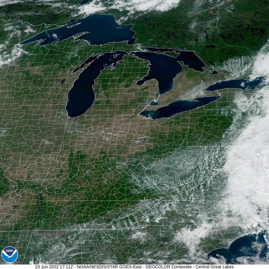
Man, it is hot in the Upper Midwest, and some of that heat is going to spread eastward. And don’t even get me started on the humidity. Air conditioners will be needed, particularly after we get away from the westerly flow off of Lake Michigan. Chicago westward through Illinois and into Deubuque will be blazing hot. The moisture is currently penned west of the Mississippi and north into Wisconsin, and there isn’t really a great reason to expect it to get unleashed terribly far from where it is right now. It will probably bleed south and east a bit, precariously close to our route, but all that will mean is an even more uncomfortable walk to the rest rooms at pit stops. Dubuque is going to be extremely sweaty tomorrow afternoon.
Happy Father’s Day all you dads out there. This forecast is dedicated specifically to the dad’s of Dubuque.
At 953AM, CT, Dubuque was reporting a temperature of 70 degrees with clear skies. Low pressure in the northern High Plains was producing brisk southerly winds across the Upper Midwest. Temperatures were on the rise in western Iowa, though Dubuque was still relatively comfortable. High pressure over the Great Lakes is strong enough that the low pressure in the Plains is going to be redirected to the north quite efficiently. While Dubuque is not expected to get as warm as locations to the west and north, but it will still be very hot in Dubuque to start the week. Part of this will be the southerly flow today, but also, the sunny skies through the beginning of the week. A weak cold front will arrive late on Tuesday that will signal a slight cool down, but isn’t expected to carry much precipitation with it. Tomorrow – Sunny, High 90, Low 63 Tuesday – Sunny, increasing clouds High 95, Low 71
TWC: Tomorrow – A mainly sunny sky. High 95, Low 65 Tuesday – Mostly sunny skies. A stray shower or thunderstorm is possible. High 97, Low 73
AW: Tomorrow – Mostly sunny, breezy and hot; caution advised if doing strenuous activities outside High 94, Low 66 Tuesday – The temperature near the record of 100 and humid; a t-storm around in the p.m.; thunderstorms can bring hail and damaging winds High 98, Low 74
NWS: Tomorrow – Sunny, High 93, Low 65 Tuesday – Sunny and hot High 96, Low 73
WB: Tomorrow – Breezy sunny, High 91, Low 65 Tuesday – Sunny. A 20 percent chance of showers and thunderstorms in the afternoon, High 94, Low 73
WN: Tomorrow – Sunny, High 93, Low 65 Tuesday – Mostly sunny, High 96, Low 68
FIO: Tomorrow – Humid throughout the day. High 91, Low 64 Tuesday – Humid throughout the day. High 95, Low 73
IT’s like there are two Dubuques we are forecasting for, and neither of them are really following model guidance closely. Today and tomorrow are going to be hot and sunny.
Not only was the weather sweltering in Shreveport this week, but it stayed hot overnight, which is the worst. Morning lows of 80 meant that air conditioners were overworked, and forecasts were off, because every outlet predicted cooler temperatures by a handful of degrees. The high temperatures, mercifully, were on the cool end of our forecasts, but that still meant mid to upper 90s. This forecast combo led to a very tight race, and a three way tie at the top, with Victoria-Weather, Accuweather and Forecast.io elevating slightly above. Actuals: Wednesday, High 96, Low 78 Thursday – High 97, Low 80
As noted in the forecast for Grand Forks forecast, some oppressive heat is getting ready to surge to the north for Fathers Day and the beginning of next week, It’s already quite hot in the south central US, but after somewhat cool springs, it will be a sudden shot of summer for many in the northern US.
Frequent bouts of severe weather have swept across the region. Strong storms have afflicted every state from South Dakota to Michigan, and even the tier to the south in the last few weeks, indicating for those that didn’t know that the jet stream has lingered over the northern US through much of the spring. The stormy activity and jet’s sag have kept temperatures cool.
Now as we approach the peak sun angle, and the warmth of June, the jet is weakening and starting to wobble. A sharp trough in the Pacific Northwest is going to be a factor in lee troughing in the High Plains, but the troughing will be well ahead of the low, giving a lot of runway to the southerly flow and the warm air that follows. Triple digits may reach the Canadian border.
Strong storms are continuing through the eastern Great Lakes after the latest round of severe weather that started earlier this week in Wisconsin and Illinois, but after today’s (enhanced risk) threat of severe storms In New York, Pennsylvania and surrounding areas, the severe threat peters out. A wonderful side effect of the weaker jet is a lower likelihood of strong storms, and this bout of severe weather looks to be the last for at least a few days.
It’s summer in North Dakota, which means that it will probably be surprising to many how hot it actually gets up there. No matter the temperature, it’s always windy. Always, always.
At 953AM, CT, Grand Forks was reporting a temperature of 67 degrees and fair skies. Winds were howling out of the west at 20kt, with gusts to 31kt. Low pressure moving into Hudson Bay was accelerating winds across the flatlands of North Dakota, but there should be some respite as the system presses northeast towards northern Quebec. High pressure will build across the area, providing a blissfully calm day on Friday to end the week. A sharp trough over the Pacific Northwest will accelerate some lee troughing in the northern High Plains, and some ridge riding cloud will pass overhead with a warm front early on Saturday. Heat will build as low pressure spreads into Saskatchewan and Manitoba, and accelerates southerly flow through the Plains. Tomorrow – Sunny, High 85, Low 52 Saturday – Morning clouds, then hot and humid High 92, Low 60
TWC: Tomorrow – Mainly sunny. High 85, Low 54 Saturday – Partly cloudy skies with gusty winds. High 91, low 63
AW: Tomorrow – Times of clouds and sun High 84, Low 54 Saturday – Partly sunny, windy and hot High 90, Low 62
NWS: Tomorrow – Sunny, High 83, Low 55 Saturday – Mostly sunny and hot, High 90, Low 61
WB: Tomorrow – Sunny, High 84, Low 55 Saturday – Mostly sunny. Windy. High 91, Low 64
WN: Tomorrow – Sunny, High 83, Low 55 Saturday – Mostly sunny, High 90, Low 59
FIO: Tomorrow – Clear throughout the day. High 80, Low 58 Saturday – Windy overnight and in the evening. High 86, Low 60
I’m definitely going warmer. The heat will continue to build, and a run at triple digits is possible for Father’s Day. The trends are going that way, and I am getting ahead of the trend. Satellite shows a wisp of clouds on the back side of the low headed through Canada, and it is windy at the surface. Always windy.