We’ve made it all the way to August, and we haven’t awarded the FOTM to our June forecaster yet! That is a consequence of the active forecast and road trip schedule we’ve had of late, but now, certainly, is the time to give some meteorologists their due.
June was a mercifully slow start to the summer, with temperatures and storms more manageable than we’ve seen in recent years. July started to go off the rails, but we can appreciate Victoria-Weather’s victory for June with some sort of peace. Congrats to us!
The end of last week in Abilene didn’t promise many changes. A slow, slow moving boundary was sinking towards the Lone Star State, but ultimately, no changes were ever seen in Abilene. Like, none. It was 101 for a high, 80 for a low on each day of our verification, with nary a drop of rain. The Weather Channel and WeatherNation secured a tie for the verification. Actuals: Thursday – High 101, Low 80 Friday – High 101, Low 80
There are quite a few news stories in the world of weather, and we will take some time to discuss them in the next few days. Fewer forecasts, but we won’t forget the rest of the weather news.
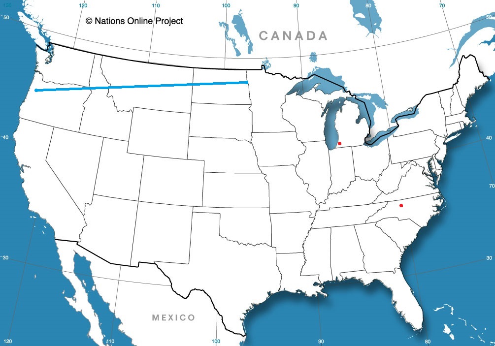
Winston-Salem, North Carolina
Benton Harbor, Michigan
Road Trip from Grand Forks, North Dakota to Corvallis, Oregon
It’s been a tough week in eastern Kentucky, as it became a focal point for heavy rain as a slow moving boundary left even slower moving torrents of rain across the state, ultimately leaving dozens dead in flash flooding, and countless more with their lives turned upside down. The news from the area continues to get worse as we find out more, and we continue to keep residents in our thoughts.
Often when rain becomes centered on one spot, as it did in Kentucky, the threat for scattered showers away from that main area diminishes. Such was the case on Tuesday and Wednesday, when Atlanta, which had been forecast for some light showers on either of those two days, successfully avoided precipitation. Temperatures climbed a couple of degrees warmer than anyone had, but it was a generally tightly clustered verification. The Weather Channel and WeatherNation were strange bedfellows, tying for the top spot. Actuals: Tuesday – High 91, Low 75 Wednesday – High 92, Low 75
Most of the people that live in Oregon live along in a north-south corridor adjacent to the Cascades. Oregon State is in Corvallis, and the town and the school are well within the corridor.
I’d be remiss if I didn’t note the historic flooding in the Ohio Valley. St. Louis recently broke a single day record for rainfall, while eastern Kentucky is seeing a rising death toll thanks to flash flooding caused by the deluge. Our thoughts are with those affected by these disasters.
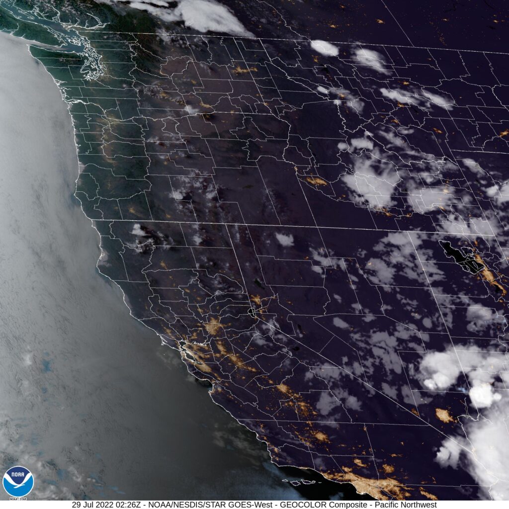
At 656PM, PT, Corvallis was reporting a temperature of 89 degrees with clear skies. Salem and Eugene, on either side of the city, were reporting temperatures of 95 degrees. Of course, along the coast with the Marine layer, temperatures were hovering in the mid 50s with clouds and fog. There was no forecast for that haze to press further ashore. Flow over the western US is fairly stagnant, with any jet structure only found well to the north, originating in the northern Yukon. As a result, heat has been allowed to build in the Pacific Northwest. While the Gulf of Alaska low was currently absent, a weak wave shifting closer to the shore will bring some cooler air late on Saturday, to be joined by some clouds. Tomorrow – Hot, High 96, Low 60 Saturday – Partly cloudy, High 95, Low 59
TWC: Tomorrow – Mainly sunny. High 98, Low 61 Saturday – Some clouds in the morning will give way to mainly sunny skies for the afternoon. High 97, Low 61
AW: Tomorrow – Blazing sunshine and hot; possible danger of dehydration and heat stroke while doing strenuous activities High 97, Low 60 Saturday – Blazing sunshine and hot; possible danger of dehydration and heat stroke while doing strenuous activities High 96, Low 61
NWS: Tomorrow – Sunny and hot, High 98, Low 61 Saturday – Sunny and hot, High 97, Low 62
WB: Tomorrow – Mostly sunny, High 97, Low 60 Saturday – Mostly sunny, High 93, Low 61
WN: Tomorrow – Mostly sunny, High 98, Low 61 Saturday – Mostly sunny, High 97, Low 62
FIO: Tomorrow – Humid throughout the day. High 93, Low 65 Saturday – Humid throughout the day. High 93, Low 63
It’s hot, but fortunately, the heat won’t be as intense or as resilient as last year’s heat wave. It is expected to break by the end of the weekend. For now, you can certainly see the clear skies over most of Oregon, but the intrusion of low clouds and fog over the coast is evident as well.
The forecast for Baltimore proved to be fairly easy to wrap our heads around. The end of the week was going to be hot, and generally free of any atmospheric changes. Mission accomplished! Everyone came in between 3 and 5 degrees of error, and there was no precipitation to worry about, so everyone can feel good about their day. Accuweather, the Weather Service and Weather Nation can feel just a little better about it though. Actuals: Friday – High 95, Low 74 Saturday – High 97, Low 77
Abilene is the first big town you see west of Fort Worth in Texas. The entire state is so big, though, it is a regional hub all by itself out there in the Plains.
At 752AM, CT, Abilene was reporting fair skies with a temperature of 82. West Texas and much of the southern Plains were south of a mostly stationary boundary along the Kansas-Oklahoma border, and it promised to get well into the triple digits south of this boundary. Heat advisories were in place for the area. Little change is anticipated for the region. The boundary has sagged south through the last couple of days, and a wave moving through the Canadian Prairies will push it even further south. The dry line will become more entrenched in eastern New Mexico, and a few clouds and increased humidity in Abilene may bring temperatures down out of the triple digit range, but if then, not by much. Tomorrow – Partly cloudy and hot, High 100, Low 77 Friday – Partly cloudy, more humid, High 98, low 78
TWC: Tomorrow – Mostly sunny skies High 101, Low 79 Friday – Sunny, along with a few afternoon clouds. High 99, Low 79
AW: Tomorrow – Mostly sunny and very warm High 101, Low 79 Friday – Mostly sunny and very warm High 98, Low 79
NWS: Tomorrow – Sunny and hot, High 101, Low 79 Friday – A 20 percent chance of showers and thunderstorms after 1pm. Sunny and hot, High 99, Low 80
WB: Tomorrow – Sunny, High 100, Low 81 Friday – Sunny. A slight chance of showers and thunderstorms in the afternoon, High 97, Low 81
WN: Tomorrow – Mostly sunny, High 101, Low 79 Friday – Mostly sunny, High 100, Low 78
FIO: Tomorrow – Clear throughout the day. High 100, Low 77 Friday – Humid throughout the day. High 100, Low 78
Hot, hot hot. But for the most part, everyone agrees it will “cool down” a bit on Friday. Make sure the sweaters are nearby.
We are headed to one of the more important weather hubs in the country, along with Silver Spring, Maryland and Oklahoma City. Atlanta is home to many weather focused corporations, notably The Weather Channel, and we are coming for you, TWC!
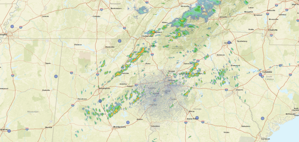
At 1252PM, ET, Atlanta was reporting mostly cloudy skies with a temperature of 87 degrees. Bands of isolated thunderstorms are stretched across North Georgia, with one particular cluster near Athens, Gainesville and Lawrenceville, and a stronger line north of Rome. There is one cell on the southeast side of Atlanta, but otherwise, there is a dry window encompassing the Atlanta area. There is an area of low pressure over Quebec dangling a cold, becoming stationary front through the Tennessee Valley, and along that boundary is a perturbation centered near the District of Columbia. This complicated set up is helping to tap into the moisture in the southeast, and touching off the banding showers and thunderstorms in north Georgia this afternoon. The threat for storms in and around Atlanta will abate a bit this afternoon, as the activity becomes more focused along the boundary to the north. That boundary is expected to remain intact even as the low over Quebec deteriorates. A second surface low moving out of the High Plains into the Great Lakes will pull the boundary a bit to the north by Wednesday, presenting a dry mid-week in Atlanta. Of course, one last perturbation along the front before it moves northward will bring some scattered showers to Atlanta first on Tuesday evening. Tomorrow – Scattered clouds with a chance for isolated showers and storms, High 88, Low 73 Wednesday – Scattered to mostly cloudy. A bit warmer, High 90, Low 73
TWC: Tomorrow – Variable clouds with scattered thunderstorms. High 89, Low 74 Wednesday – Sunshine and clouds mixed High 93, Low 73
AW: Tomorrow – Humid with intervals of clouds and sunshine High 87, Low 73 Wednesday – Partly sunny and humid; a thunderstorm in spots late in the afternoon High 91, Low 73
NWS: Tomorrow – A 50 percent chance of showers and thunderstorms, mainly after 11am. Partly sunny, High 88, Low 74 Wednesday – A 20 percent chance of showers and thunderstorms. Mostly sunny, High 91, Low 73
WB: Tomorrow – Partly sunny with a chance of showers and thunderstorms, High 87, Low 74 Wednesday – Mostly sunny with a slight chance of showers and thunderstorms, High 91, Low 74
WN: Tomorrow – Partly cloudy with chance of storms, High 89, Low 73 Wednesday – Partly cloudy, High 92, Low 73
FIO: Tomorrow – Humid and mostly cloudy throughout the day. High 86, Low 74 Wednesday – Humid and partly cloudy throughout the day. High 88, ow 75
Pretty hot couple of days in Georgia, but all that moisture around, the mountains, it keeps it from triple digits most of the time. Rain shield over Atlanta has been activated.
It takes merely one day to travel from New Haven, to Baltimore. In fact, it’s only 5 hours between the cities by car (even faster by train!) and covers 5 states. That’s a state an hour! At most times, it is a 5 hour and 7 minute drive (though significantly longer in the morning ore early evening) at a pace of only 52 miles an hour. That is CRAZY slow. This is the first time I can remember passing through Delaware on a trip, so I will blame the First State. We have 267 miles to cover, so let’s start coverin’
New haven, Connecticut
It’s the same story everywhere, man. Hot, hot, hot. Make sure that AC is working, especially in the midst of cutting across the Bronx on I-95 early in the day. Being at a standstill just makes things seem so much worse. The best chance for rain tomorrow is before we wake in the New York City area, but I suspect the green showing on the models will manifest as some ground fog thanks to high dew points in the area. The sun will get brighter and angrier as we slide through New Jersey and Delaware, before we begin our final steamy approach to Baltimore.
It’s a hot July, one of the hottest ever recorded in many parts of the world, including the mid-south in the US. Just normal — “normal” — hot out east though. Is there anything else coming with it?
At 954AM, ET, Baltimore was already reporting a temperature of 88 degrees. Mostly cloudy skies populated the region, and dew points were a soupy 73 degrees. There is an area of low pressure over eastern Canada, dangling a cold front along the Appalachians. It is a typical summer time boundary, and while there are clouds across Appalachia, it isn’t bolstered by very much cold air, and the moisture content is negligible. Still, any chance at relief will be appreciated. High pressure at the surface will remain entrenched, even as the boundary moves through Appalachia. Tomorrow may be a bit cooler than today, but high pressure is going to build back into the region on Saturday, and temperatures and humidity are expected to build right back with it. Tomorrow – Partly to mostly cloudy, High 95, Low 75 Saturday – High 98. Low 75
TWC: Tomorrow – Mainly sunny. Hot High 97, Low 75 Saturday – Mainly sunny. Hot High 97, Low 76
AW: Tomorrow – Mostly sunny High 96, Low 75 Saturday – Mostly sunny and hot; stay hydrated; signs of heat illness can include headache, dizziness and nausea High 97, Low 76
NWS: Tomorrow – Sunny, High 96, Low 75 Saturday – Sunny and hot, High 97, Low 76
WB: Tomorrow – Sunny, High 96, Low 76 Saturday – Sunny. High 96, Low 77
WN: Tomorrow – Mostly sunny, High 96, Low 75 Saturday – Mostly sunny, High 97, Low 76
FIO: Tomorrow – Humid throughout the day. High 94, Low 75 Saturday – Humid throughout the day. High 94, Low 77
That’s just a really hot stretch of days. There is a lot of similarity from day to day among the outlets, but I just think that there is too much going in the mid and upper levels for the two days to be carbon copies. One day will be cooler, probably tomorrow, and Saturday will bounce back like nothing happened. Clouds are scattered today.