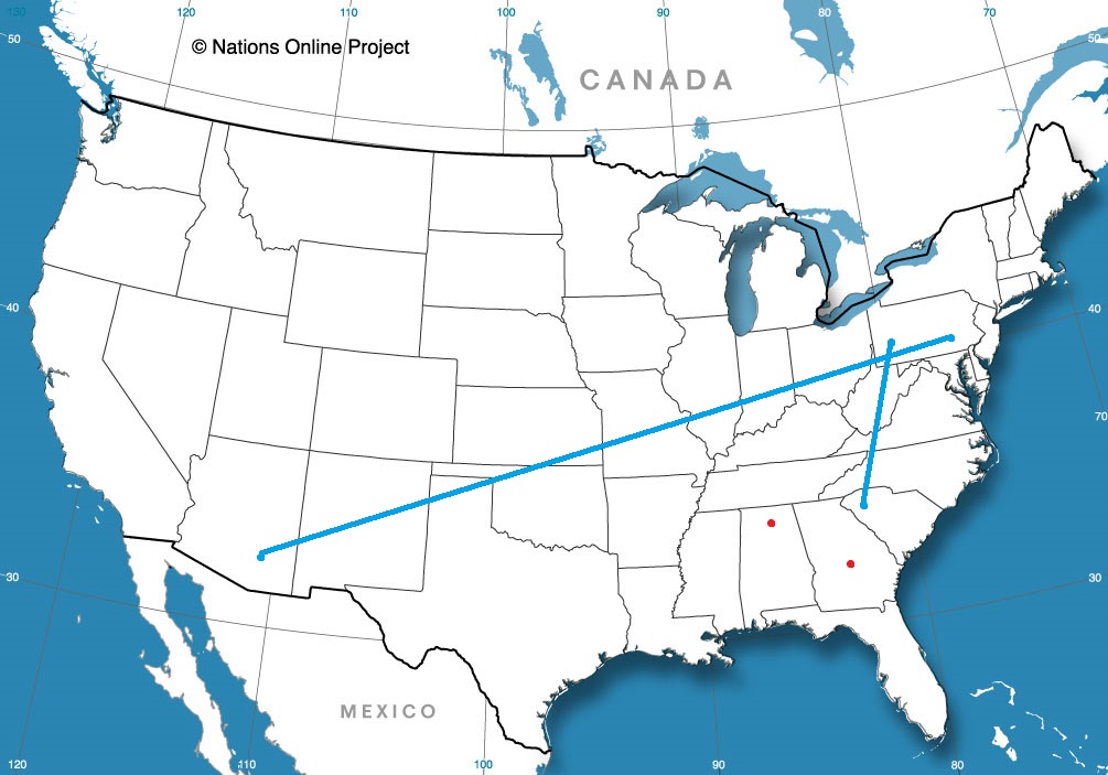
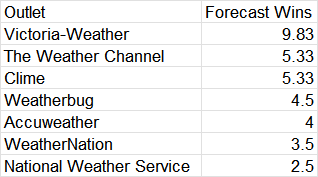
I know a big chunk of the Northern Plains saw snow late in October, but it has been nice enough to begin November that I am guessing there is a cross section that doesn’t really remember the wintry weather. As we get deeper into November, every successive storm feature is more and more likely to bring winter weather advisories, or even more severe. For example, take a look at the current advisories from the NWS:
There are advisories for the Cascades, Sierras and Wasatch Mountains. It’s still early enough in the season that the first few waves necessitate a warning, but late enough that the snow is definitely here.
We’re getting deeper into fall, heading into the Holiday Season. Here’s hoping that weather cooperates for all of us in our travel plans. We have a couple of east coast road trips that might give a lot more people some weather information than just those in the destinations at either end of the trip, what with the heavily traveled roadways in question.
Flagstaff, Arizona
Road Trip from Lewiston, Maine to Salisbury, Maryland
When we forecast for Logan over the weekend, I noted that some of the outlets were trending away from each other, and I suspected that it was because the model guidance updated, and some outlets jumped on the changes and others hadn’t updated their forecast yet. I presumed I had the freshest data, and if that was the case, then that was what led to Victoria-Weather’s forecast victory for Logan. The new data was cooler overnight, which was the fate that befell Logan. Actuals: Saturday, High 51, Low 23 Sunday, High 55, Low 24
Let’s hit the road for a 4 day trip to the West Coast. We are enjoying a stretch of quiet weather throughout most of the country, so let’s see if that holds for our 2,298 mile journey. We’ll have a pace of 67.6mph, which means the first three days will have a goal of 541 miles, with a longer day coming for Saturday.
DAY ONE (Wednesday)
Lima, Ohio
Low pressure is churning in the northern Gulf of Mexico, bringing much needed rain to the Coast, and importantly, preventing much moisture from building into the middle of the country. Our first day of driving will be pretty easy, frankly, and we will see 4 states by the end of it. The stop for the night will be near Devil’s Elbow, Missouri, the site of the last part of the original Route 66 that was in use before being replaced by Interstate.
DAY TWO (Thursday) Low pressure isn’t entirely the property of the Gulf. The Polar Jet is running along the Canadian border, and is going to kick up a Clipper that will charge through the Canadian Prairies. By Thursday, a cold front will slice through the Plains, and we will cross paths with it as we reach the end of our day in Amarillo. That said, don’t be surprised to see winds really pick up around Oklahoma City and continue through the day.
DAY THREE (Friday) The wind will subside, and temperatures will be a bit chillier than when we awoke the morning before, even though we are a bit further south. The drive will be pretty easy, albeit barren of many chances to stop for gas. We’ll traverse New Mexico and eventually land in the Chevalon Creek Wildlife Area, not far from Winslow, and quite the beautiful spot.
DAY FOUR (Saturday) I would say that 3/4ths of the drive on Saturday will be free of issues, but we are approaching the rainy season in California, and it is trying to start on time. An area of low pressure is moving near the coast by the weekend, and after we cross the Cajon Pass to Pasadena, we will be under the threat for some light showers. Our route will hug the San Gabriel and Topatopa Mountains, which will only make rain likelier, which isn’t great news, because Californians aren’t the best at driving in inclement conditions. We’ll make it, though, and prepare for things to green up with this taste of rain.
We wrote a couple of follow ups recently, from the approximate end of the Atlantic Hurricane Season and the October Forecaster of the Month. It is easy to wonder how different things would have looked if it had been a busy landfalling October, to see where our attention was and how the outlets did, comparatively. As it was, we were all pretty similar in effectiveness.
When we forecast for Sherman last week, expectations were low. It was going to be sunny with some late season warmth, and not a lot of intrigue. The biggest question was how warm would it get on Election Day, and how Accuweather has time to add notes to all their local forecasts. I still have no answer for the second question, but I can tell you it hit 86 last Tuesday, which was warmer than all forecasts. This handed the victory to the warmest forecaster, who happened to be Victoria-Weather. Actuals: Monday – High 82, Low 63 Tuesday – High 86, Low 63
Wow, what a busy, wild Atlantic Hurricane season it has been! Oh, you don’t think so?
Let me run through some stats for you. There were 20 named storms, 7 hurricanes and 3 major hurricanes. That’s a higher than normal number of named storms, and about average on the hurricanes and major storms. Do any of them really stand out in your mind?
Hilary was a Pacific storm that inundated the southwestern US. Otis, North America’s most deadly storm, also came from the Pacific before it blasted Acapulco last month. The Pacific was certainly busier than normal, and saw more storms spiral back into the mainland than normal.
Rare is the season that we remember the Pacific more vividly than the Atlantic, but here we are. The three strongest storms in the Atlantic were Franklin, Idalia and Lee. Lee was the strongest, but managed to avoid large land masses when he was at the strongest, ultimately making landfall in Nova Scotia as a shadow of his former self.
Idalia, if any, is the storm we will remember. Insurance adjusters certainly will, but fortunately, the deadliest, most costly storm of the season claimed just 7 lives, despite hitting impoverished Hispaniola, Cuba and the Yucatan before landfalling in Florida near Apalachee Bay. Idalia did bring some incidental flooding and wind issues to Tampa and Tallahassee, but didn’t make a direct impact on any major population centers, blunting the loss of life as well as reducing the total damages.
In a period of history when we have dealt with deadly storms quite regularly, it’s great to have a year that was more fortunate. Make no mistake, though, this wasn’t a quiet year, just one where the storms kept their distance from the mainland.
It was a busy month of forecasting in October, but the only thing spooky about the month in the end was how closely contested it was. Only the National Weather Service failed to secure even a share of a forecast victory during the month. That meant the rest of the outlets were neck and neck. There was a three way tie for third, and they were only shortly behind Accuweather, who got the slim win.
Remember 2010, when Eyjafjallajökull erupted in Iceland, and kicked up so much ash that it crippled North Atlantic aviation for weeks at a time? Well, there is another large eruption in Iceland anticipated near the Grindavik region, but for now, there are no concerns that there will be similar disruptions.