It looks like the Upper Midwest will miss winter

When encountering anyone here in Minnesota lately, the generic weather conversation always steers towards how snowless the winter has been. There is also always the circumspect admonishment that we are probably really going to get hammered in March and April, but the most recent look ahead from the Climate Prediction Center suggests that time is running out for a real shot at snow.

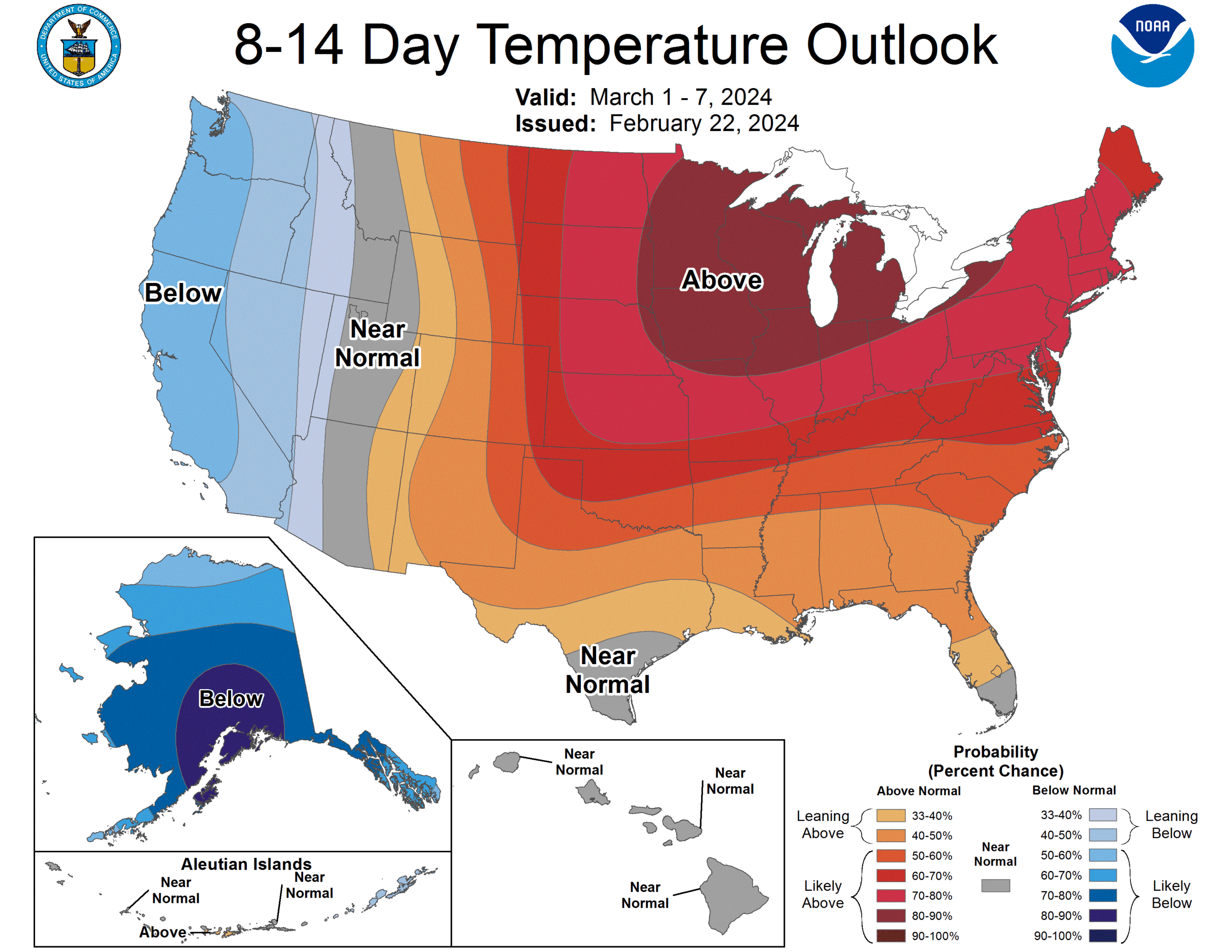
For the end of February, and then to start March, it’s going to be well above normal in the Great Lakes. This, as we head further away from the coldest part of the year means that the time for snow is likely running out, with barely a foot having fallen over the course of the year.

While temperatures have indeed been quite warm all winter, the cold that settled in persistently did so without any moisture: there was no snow during the cold snaps. Snow on the ground would have helped temperatures remain a bit lower going forward, but that was one of the many compounding factors that worked against a normal winter around here.

We’ve been trending towards this being the warmest recorded winter in many places in the western Great Lakes, and a scorching start to March will pretty much lock that in.

Ocean City, New Jersey

We keep bouncing from coast to coast, so that means for this forecast, we’re hitting the East Coast.

At 1154PM, ET, Ocean City was seeing temperatures of 46 degrees and overcast skies. Rain was pressing north, and the back end of the line lay from Trenton to Farmingdale, with Long Island and southern New England seeing sustained shower activity. The upper level pattern is complicated. The deepest area of low pressure is in Canada, but a more generalized trough extends from New England to the Carolinas. Overnight, a southern, secondary low will develop in the Smokey Mountains and shift off shore through tomorrow evening, bringing more rain to Ocean City through Friday.
On Saturday, the low will move offshore and start headed to the Maritimes and pull cold air into the mid-Atlantic. There will be some snow in the northern Appalachians, but only patchy clouds and a return of cooler temperatures are expected to start the weekend in Ocean City.
Tomorrow – Scattered showers, especially in the early afternoon, High 48, Low 42
Saturday – Clearing, High 44, Low 32

TWC: Tomorrow – Rain showers in the morning becoming a steady light rain in the afternoon High 51, Low 42
Saturday – Sunshine and clouds mixed. High 44, Low 35

AW: Tomorrow – Occasional rain; breezy this morning; a brief cold shot to start the weekend High 49, Low 42
Saturday – A shower in spots in the morning; otherwise, breezy with times of clouds and sun High 44, Low 36

NWS: Tomorrow – Rain likely. Patchy fog after 8am. Otherwise, cloudy High 50, Low 41
Saturday – Mostly sunny, High 42, Low 36

WB: Tomorrow – Rain likely. Patchy fog. High 48, Low 43
Saturday – Partly sunny, High 44, Low 29

WN: Tomorrow – Mostly cloudy with light rain, High 48, Low 44
Saturday – Partly cloudy, High 44, Low 32

CLI: Tomorrow – Rain showers, H8gh 50, Low 36
Saturday – Mostly cloudy, High 44, Low 20

Temperatures are going to hover and steadily drop. It’s possible all highs and lows are around midnight, so that stinks for my ability to hammer this out quickly. Here is the radar, with rain pulling away, for now, from Ocean City.

San Diego, California

We’re forecasting in southern California today. It’s been a rainy start to the week, which has become a regular trend this month.

At 751AM, ET, San Diego was reporting a temperature of 51 degrees with overcast skies. The most recent band of rain showers was still leading to reports of light rain in Oceanside, but was starting to peel away from the coastal areas, and becoming an issue primarily for the Inland Empire and Mohave Desert. In the wake of another rain event, there are flood watches throughout the San Diego area.
A smattering of light showers will continue throughout the day, particularly in the higher terrain of southern California, with an end coming before nightfall. Robust onshore flow at the upper levels will likely lead to some cloudy conditions even after the rain ends. A large area of low pressure off the coast of northern California is expected to linger, sending moisture rich ocean air at the low levels as well, which may mean morning fog the next couple of days in San Diego, but there will be a break from the rain until at least next week.
Tomorrow – Mostly cloudy, High 61, Low 52
Friday – Morning haze and fog, then clearing, High 70, Low 51

TWC: Tomorrow – Partly cloudy. High 64, low 51
Friday – Cloudy skies early, then partly cloudy in the afternoon. High 70, Low 50

AW: Tomorrow – Areas of fog in the morning; otherwise, clouds giving way to some sun; a welcome break from recent heavy rain High 64, Low 49
Friday – Patchy fog in the morning; otherwise, clouds giving way to some sun High 70, Low 49

NWS: Tomorrow – Mostly cloudy, then gradually becoming sunny High 64, Low 49
Friday – Sunny, High 70, Low 50

WB: Tomorrow – Partly cloudy, High 62, Low 50
Friday – Partly cloudy in the morning, becoming mostly sunny, High 68, Low 48

WN: tomorrow – Partly cloudy, High 64, low 51
Friday – Mostly sunny, High 68, Low 51

CLI: Tomorrow – Partly cloudy, High 64, Low 48
Friday – Sunny, High 70, Low 45

What a relief for San Diego to start coming out of this soggy week. It might even warm up a bit over the coming days and help San Diego feel more like San Diego again. Not much left on radar, fortunately.

Columbus, Georgia to Hattiesburg, Mississippi

We’re going to spend most of this 5 hour drive in Alabama, touching Montgomery and Mobile along the way. This pretty short drive will cover 327 miles at a pace of 64.1mph, which is also pretty reasonable for a short trip. All right, places to be, let’s go.

Columbus, Georgia

There is a strong area of low pressure in the Canadian Maritimes, and it is producing a cold front that is very active even in central Florida tonight. The boundary is reinforced by an area of low pressure emerging in the Gulf of Mexico. The increasing circulation will induce northerly winds in the southeastern US. While Florida will be particularly rainy, Alabama and it’s neighbors will be seasonably cool, with bright blue skies. It won’t even be humid in southern Mississippi when we arrive Sunday afternoon.

Hattiesburg, Mississippi

A regular reminder to follow the jet stream

Two of the larger weather stories in the last several weeks have surrounded the flash flooding and heavy rainfall in southern California, and now, this week, even yesterday, is the snow falling in New York City and surrounding areas. These are two major media centers, so they get more coverage than the tornadoes in Wisconsin or the severe weather in the southeast of the last couple of days, but they share more in common than just their notoriety.

As I have noted in the past, the thing you have heard of as the “atmospheric river” is basically the conveyor of systems that follow the jet stream. The jet doesn’t typically dig far enough south to be directed at the LA Basin, but that’s exactly what happened earlier this month, when flooding rain came to the region.

Typically, high pressure is in control in the Pacific off the coast of Southern California, which deflects the jet as well as features that would follow the jet. When the jet sinks south and well formed features can move into the Los Angeles area, they interact with the rugged terrain, and flash flooding can arise very quickly, as it did this month.

The jet actually sunk further south out west, but a southwest to northeast streak ran back north through Mexico, the Gulf and along the East Coast. The whole conveyor belt of energy is more familiar in this part of the world, but gave rise to the severe weather in the southern Plains over the weekend, and the snow that fell in the Mid-Atlantic yesterday.

We are used to systems following this jet streak pattern giving rise to nor’easters along the east coast. Because the area within the trough when the jet is angled at southern California is over the ocean, cold air doesn’t move in. On the East Coast, the trough is over the chillier continental US, which means snow on the north side of the jet streak. On this occasion, it was quite a bit of snow.

The jet responds to temperatures over land, but also currents and sea surface temperatures. This is the direct impact that El Nino and La Nina play on the weather over a season. It pays to pay attention when we are in one or the other, because of the role it plays in the jet stream course for a particular season. Knowing where the jet lies goes a long way to telling us what the pattern is going to be.

Dropping Off

Things sure can change in a week. We looked at Springfield, Massachusetts about this time last week, and it was ensconced in high pressure. This led to a pretty quiet forecast with a broad range of temperatures. Today, weather has rolled in, and many parts of New England and the Mid-Atlantic are seeing significant snowfall, and in some placed, seeing it for the first time in a while. The biggest hang up in the forecast was that dynamic change in temperatures, especially at night. Clouds never really played a factor, and the morning low on both Wednesday and Thursday fell below expectations. Clime had a good day, however, and was rewarded with the top forecast for the day.
Actuals: Wednesday – High 44, Low 19
Thursday – High 50, Low 22

Grade: C-D

Video: February Tornado drops near Madison, Wisconsin

Check out the above video from the Milwaukee Journal-Sentinel. A tightly wound area of low pressure, remnant from the activity seen in southern California earlier in the week, swept through the Western Great Lakes yesterday, feasting on very warm temperatures to trigger severe storms from Dubuque, Iowa to Lake Michigan.

The tornado did cause some damage in the Wisconsin town of Evansville, which is south of Madison. The twister will likely be rated as an EF2, based on some estimates I’ve seen, which is quite strong for an offseason storm. The damage around Evansville was enough that US-14 was closed until midday today.

The system also provided very gusty wind in the wake of it’s passage, reminiscent of some early autumn systems in this part of the country. Snow is falling in northern Minnesota, Wisconsin and the Upper Peninsula of Michigan today thanks to the cold air funneled in. The intensity of this clash of air masses is atypical in what should be the dead of winter, and was clearly enough to produce this tornado.

The rest of the month of February looks just as unrelenting as the first week. Temperatures will be below normal for a lot of country, especially east of the Rockies. Meanwhile, more moisture is coming for the west coast. There will naturally be immediate consequences out west, where more moisture is not needed, but also, the change in pattern indicates a pretty wild shift to get there.

Wind, hail blowing through Wisconsin

A tightly wound area of low pressure, remnant from the terrible flooding in the Southwest, is plowing through the Great Lakes. It’s February 8th, and the feature is intense enough that it is producing storm reports, including 50mph wind and 1 inch hail.

I should note that these are simply the most recent observations, with the wind coming from the system in the area, but there was even a tornado observed south of Madison this afternoon. It was the first February tornado in Wisconsin in recorded history.