I don’t know what happened to Weather Underground, our traditional source for verification information. This time around, the problem was attribution. They kept reverting back to weather information for Florence when I sought info on Sumter. It’s too bad for us, because we verified better against Florence’s figures. When running the correct verification, Victoria-Weather fell off, and the cooler numbers in the afternoon, with cooler overnight lows gave the win to the trio of Accuweather, The Weather Service and WeatherNation Actuals: Friday (the 26th) High 86, Low 68 Saturday – High 90, Low 64
We are going to sneak close to home tonight, going down to Rochester, the home of the Mayo Clinic.
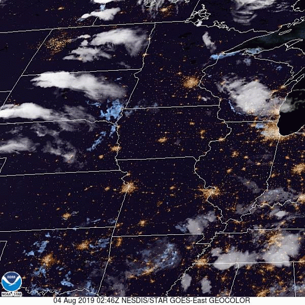
At 1254AM, CT, Rochester was reporting a temperature of 67 degrees with fair skies. Low pressure moving through northern Manitoba is inducing a lot of low level moisture northward, and dewpoints across the region were high. Fog is likely to settle in in low lying areas overnight, particularly given the clear skies. Between the low in Manitoba and the remnants of a system in northern Quebec, there has been a rise in instability in the Upper Midwest, with scattered showers through Wisconsin on Saturday. The Manitoban low will bring some drier air into northern Minnesota on Sunday, and continue through the southern part of the state on Monday. As a result, shower and storm activity will become more voluminous, and depending on the available energy, there is a chance for some severe weather in the Rochester area on Monday. Tomorrow – Isolated showers and thunderstorms, High 85, Low 64 Monday – Scattered showers and thunderstorms, High 82, Low 66
TWC: Tomorrow – Sunny, along with a few afternoon clouds. High 85, Low 65 Monday – Mixed clouds and sun with scattered thunderstorms. Storms may contain strong gusty winds. High 81, Low 68
AW: Tomorrow – Partial sunshine; humid High 84, Low 65 Monday – A strong afternoon thunderstorm; storms can bring flooding downpours, large hail and damaging winds High 82, Low 67
NWS: Tomorrow – Patchy fog before 8am. Otherwise, mostly sunny High 85, Low 63 Monday – Showers and thunderstorms likely, mainly before 1pm. Partly sunny, High 85, Low 66
WB: Tomorrow – Mostly sunny, patchy fog in the morning, High 84, Low 65 Monday – Numerous showers and thunderstorms, high 82, Low 68
WN: Tomorrow – Partly cloudy High 85, Low 63 Monday – Partly cloudy with numerous thunderstorms, High 85, Low 66
FIO: Tomorrow – Partly cloudy throughout the day. High 85, Low 65 Monday -Rain in the afternoon and evening. High 83, Low 69
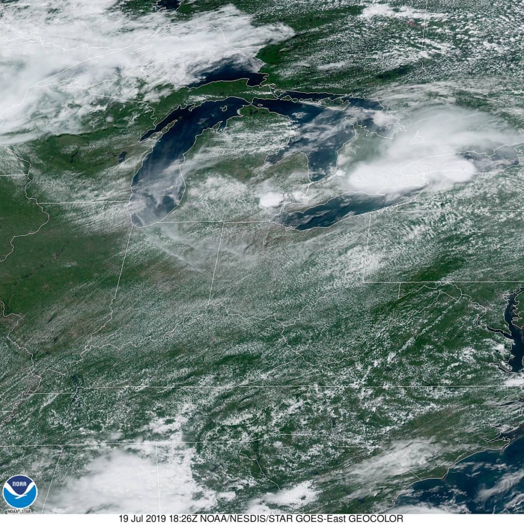
The timing everyone has for precipitation is all different. Several outlets have rain starting shortly after midnight on Monday, while others don’t have it until the evening. Meanwhile, we have a chance on Sunday. Here is a loop of the day’s satellite imagery, showing the thunderstorms moving through Wisconsin, and fog developing up by Duluth.
Back in mid – July (that’s how far behind I am on these verifications) we looked at the western Michigan town of Muskegon, which was to receive a healthy wallop from a mass of storms moving through Minnesota and Wisconsin. Those storms proved stronger than expected in the Upper Midwest, and generally lasted longer in Michigan than anyone thought. What really surprised all outlets was how little the high temperature was impacted on Sunday the 21st. After a high of 89 on the 20th, it only dipped to 87 for a high on Sunday. Not really a terrific forecast, but not really terrific weather, either. Actuals: Saturday – .51 inches of rain in thunderstorms, High 89, Low 71 Sunday – Thunderstorms reported, not measured, High 87, Low 69
Something about Pocatello always seemed interesting to me. If I’m being honest, I think I just like the way the name sounds.
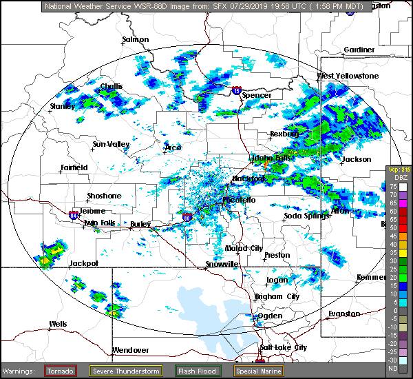
At 127PM, MT, Pocatello was reporting a temperature of 83 degrees with a brisk wind from the northeast, right down the Snake River Valley. There is a general area of showers in the higher terrain east of Idaho Falls contributing to the brisk winds, and any lightning that results from these showers will be particularly dangerous, as the region is tinder dry. A weak ridge over the Rockies is no match for the monsoon, which will continue to bring showers and storms to the Tetons, particularly in the afternoon for the next two days. Showers and storms aren’t likely to settle down into Pocatello, but similar to today, wind is likely to rush in and the fire threat probably won’t abate. Tomorrow – Partly cloudy and hot, High 95, Low 53 Wednesday – Mostly cloudy, High 96, Low 57
TWC: Tomorrow – Sunshine along with some cloudy intervals. High 94, low 57 Wednesday – A mix of clouds and sun early, then becoming cloudy later in the day. High 91, Low 61
AW: Tomorrow – Partly sunny; hot High 95, Low 58 Wednesday – Rather cloudy High 92, Low 59
NWS: Tomorrow – Sunny, High 93, low 61 Wednesday – Partly sunny, High 91, Low 61
WB: Tomorrow – Sunny, High 89, Low 57 Wednesday – Mostly sunny, High 88, Low 57
WN: Tomorrow – Mostly sunny, High 93, Low 60 Wednesday – Partly cloudy, High 91, Low 63
FIO: Tomorrow – Partly cloudy throughout the day. High 94, low 59 Wednesday – Mostly cloudy throughout the day. High 93, Low 62
Look at that range in high temperature forecasts! For a forecast with no rain involved, we can brand this as E for exciting. Here is a look at the radar, with those storms over the Tetons.
That’s generally the rule of thumb for forecasting in Florida, especially in the summer months. Last weekend was our valid time for our forecast for Deltona, and there were a handful of outlets that unconscionably left rain out of the forecast one one or both days. Mistake. Because we stuck to our mantra, we won the forecast despite some pedestrian temperature forecasting. Actuals: Friday – .36″ of rain in thunderstorms, High 95, low 75 Saturday – High 93, Low 75
Sumter is sort of an in between town. It’s not a coastal town, but it’s not very far inland either. What is the leading factor in the weather in Sumter? I reckon’ we’re about to find out.
At 1055AM, ET, Sumter was reporting a temperature of 81 degrees with sunny skies. After a muggy weekend, an unseasonably strong cold front has swept unpleasantness off the coast, and high pressure has built into the Carolinas. The remnant boundary will lay astride of the coast, and within the convective remainder, a tropical wave will become involved and briefly intensify before pulling the dry continental air further into South Carolina, and the showers and storms at sea further into the Sargasso. All the while, Sumter looks to enjoy a whole lot of sunshine. Tomorrow – Mostly sunny, High 89, Low 65 Saturday – Hot but clear, High 90, low 64
TWC: Tomorrow – Sunshine and clouds mixed. High 88, low 66 Saturday – Plentiful sunshine High 89, Low 65
AW: Tomorrow – Intervals of clouds and sunshine High 87, Low 66 Saturday – Mostly sunny High 89, Low 65
NWS: Tomorrow – Partly sunny High 88, Low 67 Saturday – Mostly sunny, High 89, low 65
WB: Tomorrow – Partly sunny High 87, Low 68 Saturday – Mostly sunny, High 87, low 67
WN: Tomorrow – Partly cloudy High 88, Low 67 Saturday – Mostly sunny, High 89, low 65
FIO: Tomorrow – Mostly cloudy throughout the day. High 88, Low 69 Saturday – Partly cloudy throughout the day. High 89, Low 67
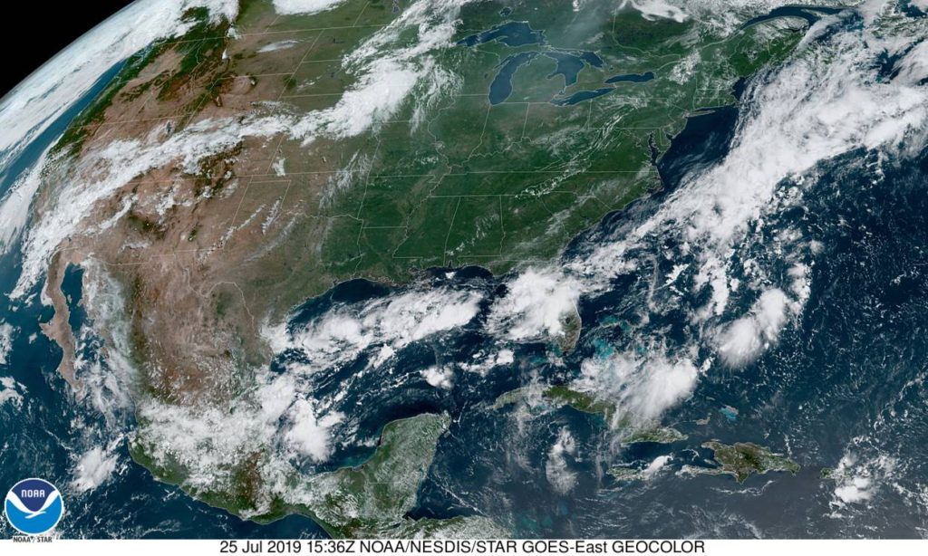
All told, especially after this past week, that’s not really a bad outlook for South Carolina. Here is a look at the western Atlantic satellite, showing the instability off shore.
A lot was made of the heat indices in the 110’s across a broad swath of the Plains east through the Great Lakes to the Mid-Atlantic, but Huntsville is at higher elevation, and was battling an area of low pressure that was bringing clouds to the region and some spots of rain near (but not in) Huntsville on Friday and Saturday. Temperatures, as a result, barely scraped 90. Still hot, but not as hot as it could have been. The problem was overnight, when lows were in the muggy low 70s. That’s tough, as the body can’t cool down and recharge, and is an underrated danger of heat waves. As for the verification of Thursday’s forecast, there was a quartet of forecasters on level pegging: Victoria-Weather, The Weather Channel, Accuweather and Forecast.io. Actuals: Friday – High 90, Low 73 Saturday – High 88, Low 72
Today seems to be an interesting day in the weather department, particularly in western Michigan. How interesting? Why don’t we find out?
At 1155AM, ET, despite a stiff breeze off of Lake Michigan, Muskegon was reporting 87 degrees, clear skies and a dew point of 70. While the heat was oppressive nearly everywhere, the instability was mounting. A area of low pressure in the lee of the Rockies extended a weak stationary boundary towards Hudson Bay, and it appears that this is the perfect vehicle for a severe outbreak tonight. Tomorrow, the stationary front will begin to sink southward as a slow moving cold front, which will bring in more comfortable and more stable air, but before that on Saturday, another similar looking squall line will role through Michigan with a little more intensity than the one that will arrive late tonight. Heavy rain and thunderstorms will be possible, particularly tomorrow afternoon, with lighter rain in the evening. Clouds will linger through the morning on Sunday, however they will clear to the south, and much more moderate air will take over western Michigan to conclude the weekend. Tomorrow – Clouds, with rain and thunderstorms especially in the afternoon and evening, High 86, Low 72 Sunday – Early clouds then clearing and pleasant, High 80, low 65
TWC: Tomorrow – Partly cloudy in the morning followed by scattered thunderstorms in the afternoon. Storms may contain strong gusty winds. High 86, Low 73 Sunday – Overcast with rain showers at times. High 82, Low 68
AW: Tomorrow – Variable cloudiness, warm, very humid; an afternoon shower or thunderstorm around High 86, Low 75 Sunday – A passing morning shower; otherwise, mostly cloudy High 82, Low 70
NWS: Tomorrow – A slight chance of showers and thunderstorms before 8am, then a chance of showers and thunderstorms after 2pm. Partly sunny, High 87, Low 76 Sunday – Showers and thunderstorms likely, mainly before 8am. Partly sunny, High 82, Low 69
WB: Tomorrow – Partly sunny with a 40% chance of showers and thunderstorms. High 84, low 73 Sunday – Partly sunny until midday, then becoming mostly sunny. A 40 percent chance on showers and thunderstorms, High 82, Low 69
WN: Tomorrow – Partly cloudy with scattered storms, High 87, Low 77 Sunday – Partly cloudy with thunderstorms likely, High 82, Low 69
FIO: Tomorrow – Possible light rain tomorrow evening. High 88, Low 73 Sunday – Mostly cloudy throughout the day. High 84, Low 69
This is the rare non-standard day in the heat of summer. Tonight, the temperature will only get down to about 80 degrees, which is uncomfortable.
With all the focus on the 50th anniversary of the Moon Landing, I think that a trip to the Space Coast and a rapidly developing town near Cape Canaveral is very appropriate.
At 336PM, ET, Deltona was reporting a temperature of 88 degrees, and thunderstorms in the vicinity. In fact, they were reporting lightning from all quadrants. It paints a more aggressive picture than what radar indicates. but there is a band of storms south and east of town that is the most robust. It’s that time of year for Florida, in which the dynamics are very small scale, reliant on the temperature profiles of see and land as opposed to any broad scale waves. Indeed, Deltona is going to be answerable only to the day time seabreezes as opposed to any broad scale flow pattern. Expect carbon copies of the next two days, with thunderstorms fairly likely, thanks to Deltona’s position set inland. Tomorrow – Scattered PM thunderstorms, High 95, low 77 Saturday – Scattered PM Thunderstorms, High 95, Low 77
TWC: Tomorrow – Partly cloudy in the morning followed by scattered thunderstorms in the afternoon high 92, Low 75 Saturday – Partly cloudy with afternoon showers or thunderstorms. High 93, Low 75
AW: Tomorrow – Sunshine and some clouds High 92, Low 75 Saturday – Partly sunny, a shower or thunderstorm around in the afternoon High 93, Low 75
NWS: Tomorrow – Mostly sunny and hot, High 95, Low 77 Saturday – A 30 percent chance of showers and thunderstorms after 2pm. Sunny and hot, High 96, Low 77
WB: Tomorrow – Partly cloudy. A chance of showers and thunderstorms in the late morning and afternoon, High 91, Low 78 Saturday – Partly cloudy. A chance of showers and thunderstorms in the late morning and afternoon, High 90, low 78
WN: Tomorrow – Partly cloudy with scattered storms, High 93, Low 76 Saturday – Partly cloudy with scattered storms, High 95, Low 75
FIO: Tomorrow – Humid and partly cloudy throughout the day. High 93, Low 76 Saturday – Humid and partly cloudy throughout the day. High 94, Low 75
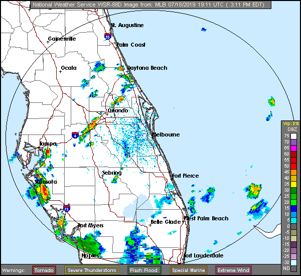
Hot and humid. Exactly what we want from Florida in July. Here is a look at the radar in central Florida.