Auburn, Alabama to Fond du Lac, Wisconson

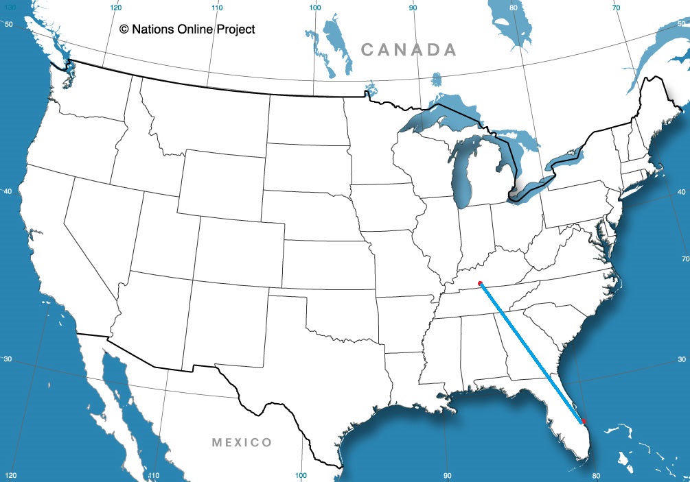
Today’s journey takes us along I-65, one of my old favorite arteries, running from Chicago to Montgomery, but we will end up both north and south of that highway by the time all is said and done. It’s a 2 day trek covering 931 miles. The first day will be longer, concluding after about 502 miles. We’re going to see some weather, so hopefully we make good time outside of the storms.

DAY ONE (Thursday)

Auburn, Alabama

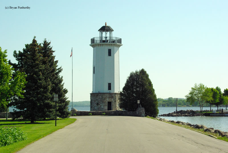
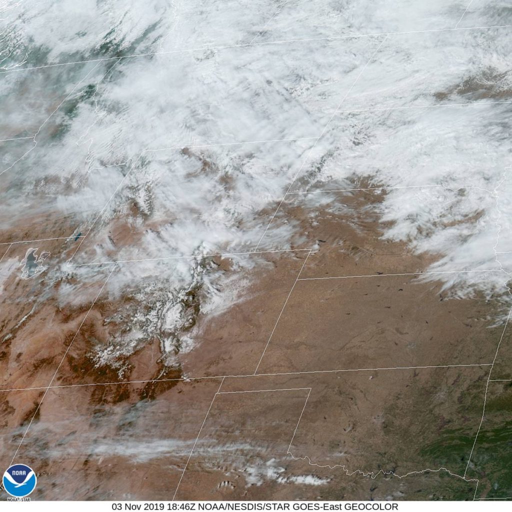
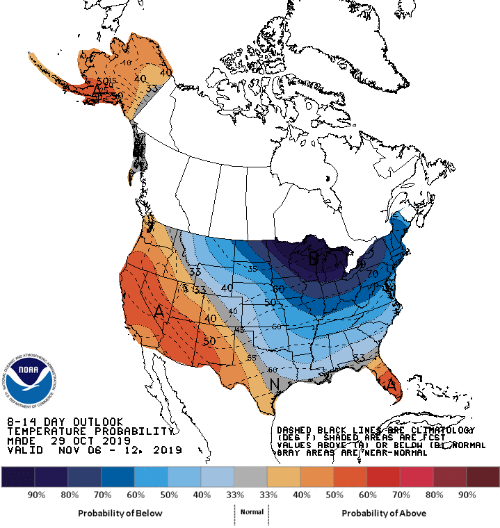
The weather is going to be nice in Alabama tomorrow morning, as warm Gulf air is drawn northward, taking the edge off of the autumn by just a little bit. Nice! Of course, the reason it is going to move to the north is a massive, nasty cold front at the leading edge of a strong ridge of high pressure sinking into the Great Lakes. The resulting boundary will be in our path, starting with a few rogue showers and thunderstorms north of Birmingham, with heavy rain and wind, perhaps even severe, in Tennessee and southern Kentucky. The trailing air mass is going to be cold an dense, so the cut off from rain to clear air will be abrupt. Expect a change in wardrobe if we need to stop anywhere north of Bowling Green, Kentucky, The night will be clear when we call it a night in Scottsburg, Indiana, north of Louisville.

DAY TWO (Friday)
While the rain we see on Thursday is going to be a pain in the butt, it will come with a good navigational consequences, Sure, Indiana, Illinois and Wisconsin will be awfully chilly, they will also be sunny and dry. With a fresh bit of snow in Wisconsin, keep those sunglasses at the ready.

Fond du Lac, Wisconsin (C) Bryan Penberthy

Smoke from a not so distant fire

I used the current fire map for the LA area as the image in the forecast for Santa Barbara to give a little perspective on the threat in the region as we started to look at the forecast. Even a few days later, the picture is wholly different, with some fires contained, some extinguished and more underway. Santa Barbara did seem to avert the worst of the fires this go around, though there was smoke reported most of the day on Friday as the Getty blaze raged and coupled with easterly winds. Victoria-Weather and Accuweather combined to net the top forecast in the area.
Actuals: Friday – High 73, Low 38
Saturday – High 78, Low 40

Grade: B-F

October Forecaster of the Month

The month of October has come and gone. North America is bucking the trend of, well, essentially the entire planet, and saw generally a cooler than normal month, but it was marked by some very warm weather type events, like a tornado moving through the Dallas city limits. If anyone is going to handle a topsy turvy. high profile month like October was, the top spot is usually going to The Weather Channel, as it does this month.

OutletMonth wins
Victoria-Weather1.83
Weatherbug1.33
Forecast.io1
The Weather Channel0.83
WeatherNation0.33
National Weather Service0.33
Accuweather0.33
OutletMonth winsyear wins
Victoria-Weather1.8314.98
The Weather Channel0.8312.53
Weatherbug1.3311.91
WeatherNation0.338.14
Forecast.io17.95
National Weather Service0.337.81
Accuweather0.337.14

Cheyenne, Wyoming

Strange that this is the furthest east we’ve been in weeks, isn’t it?

At 1053AM, MT, Cheyenne was reporting a temperature of 50 degrees with sunny skies and a brisk northwest wind of about 25mph in gusts. The off-mountain winds are certainly helping to bolster the warm up this afternoon. There was a weak ridge building in the front range as well, but most of the warm up at this time is mechanical in nature.
The upper level pattern is quite static, and a glance at the jet pattern looks to remain unchanged through the beginning of the work week. This means a tight thermal gradient just to the northeast of Cheyenne, which will result and a continuing brisk wind in the region. If the wind continues to be more westerly than northerly, Cheyenne will also be able to sustain some warmer temperatures.
Tomorrow – Partly cloudy, High 40, Low 26
Tuesday – Mostly cloudy but warmer, High 52, Low 30

TWC: Tomorrow – Intervals of clouds and sunshine. High 43, Low 27
Tuesday – Sunny skies High 55, Low 29

AW: Tomorrow – Partly sunny High 43, Low 26
Tuesday – Mostly sunny and milder High 55, Low 28

NWS: Tomorrow – A chance of flurries before 11am, then a chance of sprinkles. Partly sunny High 40, Low 22
Tuesday – Sunny, High 54, Low 23

WB: Tomorrow – Mostly cloudy, Colder, High 42, Low 28
Tuesday – Sunny, not as cool, High 55, Low 30

WN: Tomorrow – Partly cloudy, High 40, Low 23
Tuesday – Mostly sunny, High 53, Low 24

FIO: Tomorrow – Partly cloudy throughout the day. High 43, Low 26
Tuesday – Clear throughout the day. High 53, Low 29

A look at the satellite shows some striations in the clouds north of Cheyenne, which are caused by the strength of the jet through those clouds.

One off

Madera was the first of our trio of California forecasts this past week, and was the city the farthest from fire danger. It came down to how temperatures were handled by forecast guidance. Victoria-Weather was off the forecast by one degree on every verifying time by one degree, low every time. That’s just as tough to do as getting the forecast exactly right, I would say. The Weather Channel was off by a couple of degrees at two different times, and V-W and TWC ended up with a tie in Madera.
Actuals: Tuesday – High 69, Low 36
Wednesday – High 67, Low 34

Grade: A-B

Santa Barbara, California

Unlike our last trip to the Golden State, Santa Barbara is a little bit closer to the fires in Southern California, particularly the recently ignited Easy Fire, burning between Thousand Oaks and Simi Valley. What are we looking at for the next couple of days? Respite?

At 753AM, ET, Santa Barbara was reporting clear skies and a temperature of 39 degrees. Shielded by the Coastal Range, and seeing as it is fairly early in the morning, Santa Barbara was shielded from any blustery winds from the interior of the state.
In the next couple of days, a coastal trough is forecast to develop and should finally blunt the winds from the east. A little bit of latent moisture may even turn into a Marine Layer, sneaking up the coast by Saturday morning, making for a cool damp beginning to the weekend.
Tomorrow – Mostly sunny, with some smoky haze, High 74, Low 40
Saturday – Early fog, then clearing and hazy High 73, Low 42

TWC: Tomorrow – A mainly sunny sky. High 77, Low 46
Saturday – Sunny. High 76, Low 48

AW: Tomorrow – Delightful with plenty of sunshine High 75, Low 40
Saturday – Delightful with plenty of sunshine High 74, Low 42

NWS: Tomorrow – Sunny High 80, Low 44
Saturday – Sunny High 77, Low 46

WB: Tomorrow – Sunny High 73, Low 42
Saturday – Sunny High 73, Lw 46

WN: Tomorrow – Sunny HIgh 80, Low 44
Saturday – Sunny High 77, Low 46

FIO: Tomorrow – Clear throughout the day. High 73, Low 58
Saturday – Clear throughout the day. High 74, Low 61

There are some wild differences on the low temperature forecasts in Santa Barbara. Are these even all the same city? A look at the map shows that the fire danger is a little removed from Santa Barbara, but it should still be monitored.

A cool start to November is coming

After consecutive harsh winters, an early start to the below normal cold is not what most wanted to hear, but alas, we are already in the midst of it. Halloween is expected to be awfully chilly, and the beginning to November doesn’t project to be much more comfortable.

The 8-14 day outlook from the CPC, which will take us into the 11th month of the year shows that most of the country east of the Rockies is expected to be below normal.

The Great Lakes are going to be embedded in a fairly strong trough, and it isn’t likely to move very far this week. This trough will lead to a pipeline of moisture from the mid-Mississippi Valley to the Mid-Atlantic, including snow in the southern Great Lakes.

The trough is expected to be so entrenched that the Upper Midwest is actually going to be below normal for the second half of the month as well.

Salisbury, Maryland to Madera, California

All right, friends, it’s about time we engaged in a cross country, 5 1/2 day monster of a road trip. we will cover a whopping 2,914 miles to get from the East Coast to central California. A lot of time on interstates will mean a brisk 66.2mph pace and 529.8 miles covered a day on those full days in the car. We might see snow, and we might see fires Sounds pretty dynamic, doesn’t it?

DAY ONE (Tuesday)

Salisbury, Maryland

Things will be off to a good start on Tuesday, with warm high pressure settling into he Appalachians and throughout the DC/Baltimore region. We shouldn’t have any issues, even with tolls, as we will be traveling the southern route through Ohio, the one that avoids the toll road, but not Columbus. We’ll stay in Lake Darby, a western suburb of the Ohio State Capital.

DAY TWO (Wednesday)
I have some good news for Wednesday! It probably won’t snow! A warm front will reach north towards the southern Great Lakes overnight, and we will be in rain almost from the time we get moving. There is a chance at some thunderstorms over southern Indiana and Illinois, but by the time we reach Missouri, the cooler air will be moving in. The thunder threat will long be over, and instead a chilly rain will overtake the thunder. Maybe after we stop for the night in Devil’s Elbow in central Missouri, a wet snowflake could mix in.

DAY THREE (Thursday)
Undoubtedly, our coldest day will be Thursday, Halloween. How cool is it that we will start Halloween in Devil’s Elbow? We’re going to contend with the remnants of a few snow showers for the first couple hours of the day, concluding before we reach Springfield, and then Oklahoma will simply offer a chilly wind as we nagigate the Sooner State. We will only just start to enter Texas when we call it a day in Shamrock, where west winds suggest we will finally be reaching a bit warmer air.

DAY FOUR (Friday)
November will get off to a pleasant start. Nary a cloud in the sky as we head through the Texas Panhandle and New Mexico, and temperatures should start warming a bit too. We’ll stop for the night in Manuelito, New Mexico, on the Arizona border.

DAY FIVE ( Saturday)
Another day on the road out west, and another day with little to worry about. We’ll navigate Arizona without a concern, and reach southern California where it will be much warmer than we are used to. The day will end near Barstow, but far away from the fire concerns near the coast.

DAY SIX (Sunday)
I suspect that by next weekend, the fire danger in California will be significantly dampened. That will make for a less hazy drive through southern California. Madera looks to be in fine shape for our arrival.

Madera, California
By Jcarrello – Own work, CC BY-SA 4.0, https://commons.wikimedia.org/w/index.php?curid=52965015

Madera, California

The big news story out of California is once again the wildfire season, aided heavily by a robust Santa Ana wind regime. Madera lies in the Central Valley, set away from the flaming hillsides in Wine Country and northwest of Los Angeles, and are under no threat from the flames, though those brisk Santa Anas will surely cause some concerns, won’t they?

At 853 AM, PT, Madera was reporting a temperature of 46 degrees with clear skies and calm winds. Other places further south in the Valley were reporting some light haze as the brisk winds on the hills and mountains of the Golden State was not settling into the Valley.
The atmosphere is finally going to start doing some favors for the beleaguered region, as a strong trough is getting ready to dig into the Great Basin, breaking up the Santa Ana high, and allowing winds to subside. There will continue to be some breeze, though it will shift to become more north-northwesterly as a cold front tries to sneak into the area. With wind off the ocean and picking up the Kincade Fire of northern California, smoke and fog will become more likely in the Madera area Tuesday afternoon into Wednesday evening. Expect some cooler temperatures, though depending on the moisture transported into the region, those could be blunted by a lack of radiational cooling.
Tomorrow – Mostly sunny, with some haze possible, High 70, low 37
Wednesday – A bit cloudy with haze and morning fog more likely, High 68, Low 35

TWC: Tomorrow – Sunny, High 71, Low 37
Wednesday – Mostly Sunny, High 68, Low 34

AW: Tomorrow – Plenty of sunshine, High 71, low 36
Wednesday – Plenty of sunshine, High 69, Low 32

NWS: Tomorrow – Sunny, High 69, Low 39
Wednesday – sunny, High 68, Low 37

WB: Tomorrow – Sunny, Patchy frost in the morning, High 69, Low 49
Wednesday – Sunny, patchy frost in the morning, High 67, Low 36

WN: Tomorrow – Sunny, High 69, low 39
Wednesday – Sunny, high 68, Low 37

FIO: Tomorrow – Clear throughout the day. High 72, low 37
Wednesday – Clear throughout the day. High 70, Low 34

Not often that Victoria-Weather finds itself smack dab in the middle of things. The biggest surprise to me was that the GFS has a warming trend for Wednesday, and it was wholly rejected by all outlets. That doesn’t happen often. Here is the satellite image for central California. If you look closely, you can see the plume from the Kincade Fire north of San Francisco Bay.