I am impressed. The forecast for Jackson was locked and loaded to be very difficult. A massive blob of uncomfortable low pressure moving through the Great Lakes was going to manipulate precipitation types and drive temperatures steadily downward… except for when there was an intrusion of warm air as the low passed by on Saturday. It was a recipe for a difficult forecast, and by jove, this forecast was knocked out of the park. Weatherbug, in fact, only had 1 degree of error in their entire forecast. the only real loser was the city of Jackson, who had to deal with the rain, thunderstorm and snow chaser. Actuals: Sunday – .64 inches of rain, High 42, Low 34 Monday – Snow reported, not measured, High 34, Low 28
Miami isn’t the largest city in Florida, nor is it the capital, but it is probably the most famous (and surely has the largest metro area).
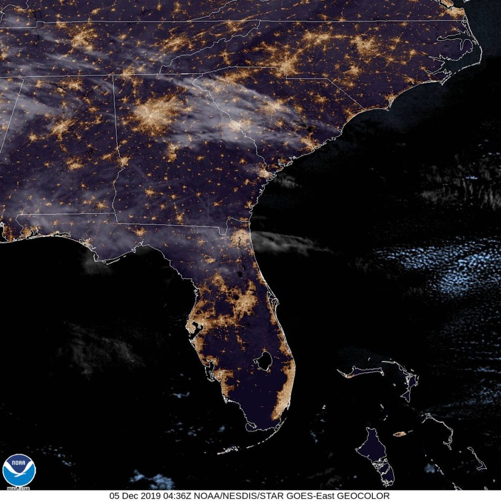
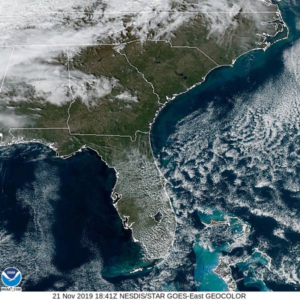
At 1053PM, Miami was reporting fair skies with a temperature of 66 degrees. The state of Florida was enjoying a pleasant evening across the board, as the subtropical jet lies safely over the Tennessee Valley. High pressure is safely entrenched over the southeast, though a short wave is forecast to develop over the lower Mississippi Valley late in the week. Because of the weak rotation in the region, expect a little bit more moisture to be entrained across Florida by Friday afternoon. bringing in some clouds. Tomorrow – Mostly sunny, fairly cool, High 75, Low 58 Friday – Partly cloudy, more humid, High 77, Low 63
TWC: Tomorrow – Mostly sunny skies. High 74, Low 55 Friday – Intervals of clouds and sunshine. High 78, Low 58
AW: Tomorrow – Partly sunny and nice High 74, Low 57 Friday – Nice with sunshine and patchy cloud High 78, Low 63
NWS: Tomorrow – Sunny, High 73, Low 60 Friday – Mostly sunny, High 76, High 65
WB: Tomorrow – Sunny, High 73, Low 56 Friday – Mostly sunny, High 77, Low 59
WN: Tomorrow – Mostly sunny, High 73, Low 60 Friday – Partly cloudy, High 76, Low 65
FIO: Tomorrow – Mostly sunny, High 78, Low 62 Friday – Clear throughout the day. HIgh 80, Low 63
This is the kind of weather you want when you visit Florida, right? Not too hot, a lot of sun and absolutely not a flake of snow.
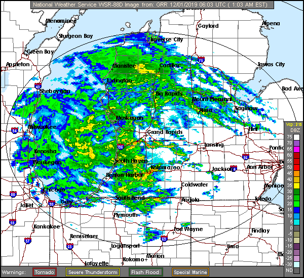
We sure are looking at an interesting forecast for the Great Lakes today. It’s a mystery even what type of precipitation will be falling in an hour.
At 1256AM, ET, Jackson was reporting a brisk 35mph easterly wind gust with overcast skies and a temperature of 37 ahead of a vast batch of heavy rain consuming most, if not all of western Michigan. A large area of occluded low pressure is centered over north central Iowa. The occluded boundary is ranging from there to Michigan. Jackson appears to northeast of the warm occlusion. Much of Michigan is in a winter weather warning or advisory, however Jackson is south of these alerts. After the rain that will come this morning, a well defined dry tongue will move into Lower Michigan through the middle of the day on Sunday. The back end of this feature is becoming significantly less organized and unable to access the same level of moisture. Still, light snow showers will persist in the Jackson region into Monday afternoon, but a cool down is not likely to follow suit after becoming cut off from the deeply occluded circulation. Tomorrow – early rain, becoming mixed and eventually predominately snow in the evening. High 37, Low 33 Monday – Light wet snow, High 33, Low 28
TWC: Tomorrow – Rain ending early. Remaining cloudy, High 43, Low 35 Monday – Overcast, early snow, HIgh 35, Low 28
AW: Tomorrow – Mostly cloudy with a couple of showers, perhaps mixed with snow late in the day High 43, Low 35 Monday – Low clouds and colder HIgh 35, Low 29
NWS: Tomorrow – Showers likely, mainly before 10am. (Late mix) HIgh 42, Low 35 Monday – Cloudy (Early mix becoming snow) HIgh 35, Low 27
WN: Tomorrow – Mostly cloudy with rain likely, High 42, Low 35 Monday – Mostly cloudy )Early mix), High 35, Low 31
FIO: Tomorrow – Rain throughout the day. High 42, Low 34 Monday – Overcast throughout the day. HIgh 35, Low 28
That was a difficult forecast. The precipitation in western Michigan has already started a transition to a mix, even as I was writing this forecast post, if that gives an idea of the uncertainty we will be dealing with.
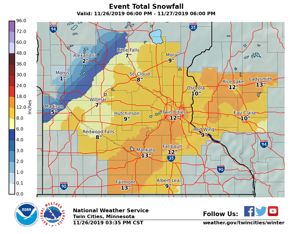
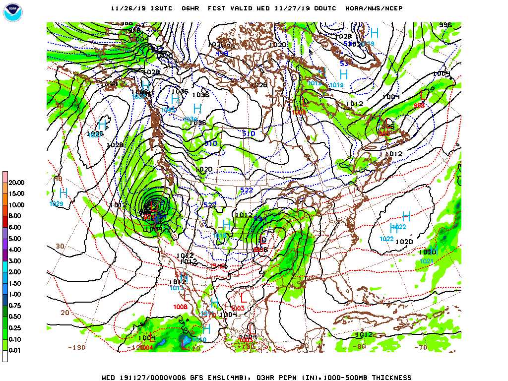
2019 may go down as one of the worst Thanksgivings for travelling in a very long time. As I sit on the south side of the Twin Cities metro area, skies are already starting to turn gray as a vast area of low pressure and some accompanying snow fall makes it’s way to the north. The latest forecast from the Twin Cities WFO calls for a foot through the heart of the metro area.
Snow has been ongoing today, particularly in northern Colorado, eastern Wyoming and across Nebraska, where it has closed schools, covered roads and severely disrupted Denver’s airport.
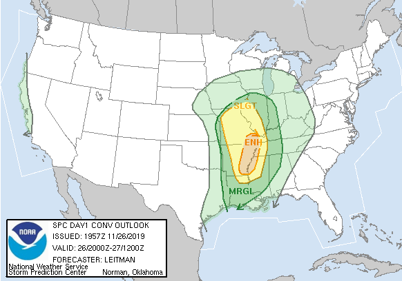
Since this isn’t a storm in the heart of the winter, there is the cold, snowy side, but also a side with strong to severe thunderstorms. There has already been one tornado warning in southern Missouri today, with more strong storms anticipated, particularly in eastern Arkansas.
The storm is going to continue strengthening over the next 12-24 hours, reaching maximum intensity somewhere over northern Wisconsin, meaning the snow that has fallen in the Upper Midwest will be , and the snow in Wisconsin and the Upper Peninsula will be wind driven. Altogether an unpleasant scenario. And that’s not even the worst of it.
THERE IS ANOTHER STORM.
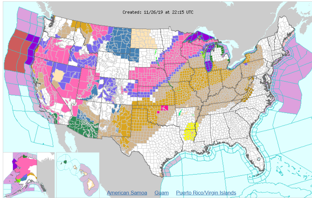
This second storm, thanks to travel across the north Pacific is in the process of explosive cyclogenesis – a bomb cyclone – and will slam into the northern California coast tonight. With it will come more gusty winds, rain and a whole lot of snow the interior west. While much of California will appreciate the rain, they could do without more wind, and the snow inland will be fairly comprehensive. That is to say, it’s not going to be confined solely to the mountains. Take a look at the watches and warnings presently plastered across the country.
All the oranges and browns are wind related alerts, thanks to the potency of the first system, while southern Arizona is also under threat for flooding, thanks to the moisture they’ve recently received, and will be reintroduced to this week.
Most of the time, foot of snow the day before Thanksgiving would be bad enough, but in the Midwest, they will also need to concern themselves with the weather after Thanksgiving. If folks somehow managed to leave the house and visit their relatives, they will then need to contend with a second round of snow that will likely start as light freezing rain, particularly from about Sioux Falls to Omaha.
In my back yard, we are probably looking at another 2-4″ of snow on top of a glaze of ice, and more gusty winds to conclude what will be a very long holiday weekend.
The cold front that roiled the afternoon in the southeastern US yesterday induced a southeasterly, onshore flow over the eastern coast of Florida. Palm Bay’s Saturday forecast proved to be a hair too warm across the board because of the cool onshore breezes. Lingering moisture kept the overnight lows from dropping off too much either. The end result of these curious happenstances was a forecast win for WeatherBug, who seem to know something we don’t this month. Actuals: Friday, High 76, Low 56 Saturday – High 76, Low 63
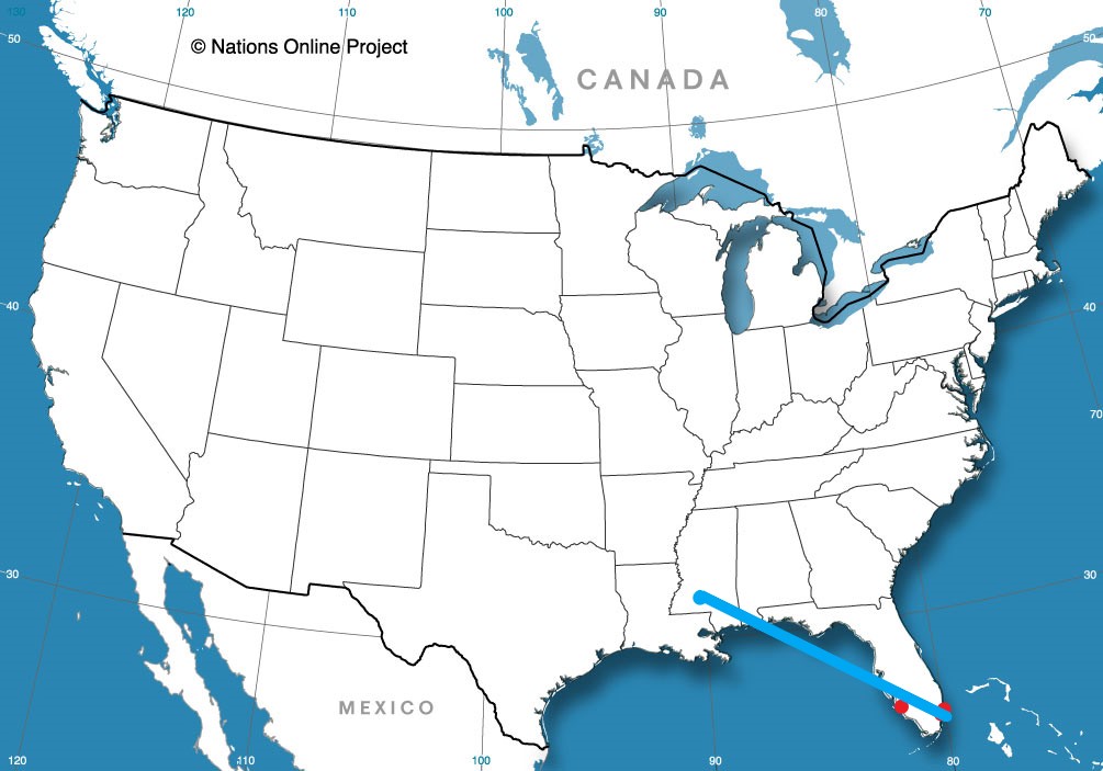
On this Saturday evening, all I can think is that this drive is going to take us right through SEC country. We’ll depart from ACC territory, I suppose, as we take an 8 hour, somewhat circuitous drive to northern Alabama. We will be on the road covering 507 miles at a pace of only 64.9mph. But really, check out this route.
Charlotte, North Carolina
There is a small, tightly wound area of low pressure shuttling through the southeastern US towards the Mid-Atlantic overnight tonight. By the time we wake up to get on the road, the low will be a thing of the past, leaving only a shallow lee trough, which may aid in the development of some fog in the wee hours. After we get to the higher terrain in South Carolina, and then head through north Georgia in the daylight, we will only be concerned with traffic and the sun shining in our eyes. All in all, Saturday will be the better day to travel this weekend.
Forecasts for Decatur were generally not too bad, save for one nasty verifying period: Wednesday morning. Even if they didn’t explicitly say they were expecting fog in their forecast (erm, I guess that was only me) it was still in the back of our minds. Decatur did see visibilities drop to a quarter of a mile in the morning, and despite that, temperatures continued to drop, all the way to 26. The 3 coolest morning lows all collected the three top forecasts, with The Weather Channel and Forecast.io earning victory. The temperature tracking surrounding the occluded front on Thursday surprisingly didn’t play into the victory totals at all. Actuals: Wednesday – High 51, low 26 Thursday – .24 inches of rain, High 58, low 40
There are so many cities in Florida, all clustered on the Atlantic coast, and we’re involved in a little East Florida two-step, recently looking at Sebastian, and now moving on to Palm Bay, which isn’t very far away at all.
At 1253PM, ET, Palm Bay was reporting a temperature of 76 degrees with fair skies. High pressure was smothering the southeastern US, allowing for the pleasant conditions. Cool air being cycled south by the remnants of Tropical Storm Sebastian was generating some rolling fair weather clouds over the southern Gulf Stream. The dome of high pressure will remain centered over the Florida Peninsula for the next couple of days, even as a wave moves southeast out of the Upper Mississippi Valley. Some return flow at the surface may lead to some extra cloudiness through all hours over the Palm Bay area. Tomorrow – Sunny, High 77, Low 58 Saturday – Partly cloudy, High 81, Low 59
TWC: Tomorrow – Partly cloudy skies in the morning will give way to cloudy skies during the afternoon. High 77, Low 59 Saturday – Intervals of clouds and sunshine High 80, Low 60
AW: Tomorrow – Partly sunny and pleasant High 77, Low 62 Saturday – Partly sunny and pleasant High 80, Low 61
NWS Tomorrow – Partly sunny, High 78, Low 56 Saturday – Partly sunny, High 81, Low 58
WB: Tomorrow – Partly cloudy, High 76, Low 56 Saturday – Partly cloudy, High 79, low 60
WN: Tomorrow – Partly cloudy, High 77, Low 59 Saturday – Partly cloudy, High 80, Low 60
FIO: Tomorrow – Mostly cloudy throughout the day. High 77, low 60 Saturday – Partly cloudy throughout the day. High 80, Low 59
Not a lot of forecast variety, but a bit of space between bosom buddies the NWS and WeatherNation. Here is the afternoon’s satellite imagery for the state of Florida.
A trip through the Rockies and Plains as a vigorous system moves through the region… I see no reason to worry! Our three day trip will feature an extended third day, and 1,861 total miles covered. We’ll navigate the terrain of the Rockies in our shorter two days, which will conclude after 551miles of travel, all at an average pace of about 69mph. Nice.
DAY ONE (Thursday)
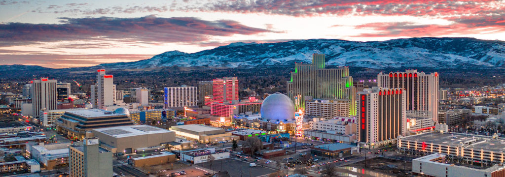
Reno, Nevada
There is a string of features extending from the northern Praries of Canada to the High Plains to the southwestern US. Epic rains are falling around Phoenix and in the southern Rockies, with snow falling at the highest peaks. By the time we get going tomorrow, the system will have weakened, with precipitation becoming limited to the upper elevations along our route. We may not see any precipitation on the roads, but there will be some nearby, in the Ruby Range in northeast Nevada, and by Park City, Utah. We’ll stop in Coalville, not too far beyond Park City.
DAY TWO (Friday) As high pressure filters back into the High Plains, moisture will be scoured out of the low lying terrain. We might see some mid level or high clouds as we trek through Wyoming, north of the snow falling in the peaks of Colorado. Wyoming has a lot of beautiful parts, but none of them are along I-80, so hustle through and get to the western part of Nebraska, where we will stop in Brule for the night.
DAY THREE (Saturday) The very same system that we saw on Thursday will be sweeping through the Lower Mississippi Valley, shuttling to the northeast. An inverted trough at the north end of the low will be pointed into Illinois, into some chilly air. Nebraska and Iowa should be sunny and dry, but the threat and intensity of snow will increase the closer we get to Decatur.