Spring is probably my favorite season. I prefer warm weather and baseball, and both return this time of year. With the warmth, the weather can get a little more interesting as well. Will it get interesting in any of the places we have forecasts for this week?
Boston, Massachusetts
Decatur, Illinois Road Trip from Augusta, Georgia to Decatur
St. George, Utah
Louisville, Kentucky
Elizabethtown, Kentucky Road Trip from Louisville to Elizabethtown
We are returning to our nation’s Capital for the forecast today. There has been a lot of nasty weather in the east and southeast of late, but now, it looks like there may be a pause. Will it old through the end of March?
At 1152AM, ET, Washington-Reagan was reporting a temperature of 52 degrees with clear skies. In the wake of the latest cold front, skies across the eastern Seaboard had cleared, and high pressure had taken hold, though a brisk west wind was leaving a bit of a chill to the air. Washington was seeing gusts approaching 30mph. A deep trough in the Plains will advance eastward and lead the complicated jet structure over the mid-Atlantic to devolve. Warm air will rise through the mid-Atlantic on Tuesday, though low pressure moving through eastern Canada will drag a cold front out of the Appalachians and into the District of Columbia by late Wednesday morning. Some development along the front around eastern Tennessee will allow for a surge in moisture in Washington, leading to a rainier day than most areas on the Atlantic on Wednesday. Some thunder will mix in late in the day, but again, a lot of the thunder will be confined to points south of the Potomac. Tomorrow – Sunny, getting warmer, High 72, Low 41 Wednesday – Rain starting in the morning, with some thunderstorms later in the day, High 66, Low 49
TWC: Tomorrow – Sunny skies High 69, Low 41 Wednesday – Cloudy with periods of rain High 67, Low 55
AW: Tomorrow – Mostly sunny High 68, Low 41 Wednesday – Cloudy with periods of rain in the afternoon High 66, Low 56
NWS: Tomorrow – Sunny, High 68, Low 42 Wednesday – Showers, High 66, Low 54
WB: Tomorrow – Sunny, High 67, Low 42 Wednesday – Rain, High 64, Low 55
WN: Tomorrow – Sunny, High 68, Low 41 Wednesday – Mostly cloudy with showers, High 67, Low 54
FIO: Tomorrow – Clear throughout the day. High 66, Low 42 Wednesday – Rain throughout the day, High 65, Low 54
Here is what Lauryn Ricketts of NBC 4 in Washington has to say about the weather in DC this week.
I posted last week about the high risk of severe weather that turned into a couple of long track supercells that fortunately avoided major population centers. Today, we weren’t as lucky.
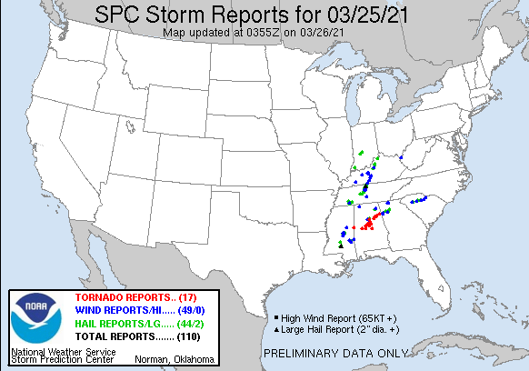
There were a few tornadic storms, but one storm in particular will be remembered for a long time. Here are the storms that have been reported today, most notably a long track, large tornado that trekked from West Blocton, Alabama to Pelham, through the south side of Birmingham, and on to Ohatchee, where 5 people lost their lives, before the rotation fell apart just inside the Georgia state line.
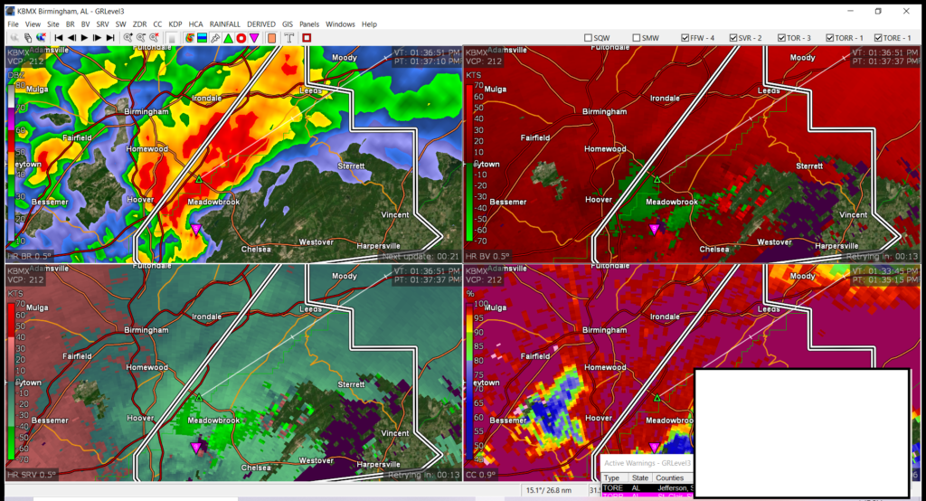
This storm was strong enough that is showed up very evidently on radar. Note the red dot in the bottom left display, near Meadowbrook. The storm had crossed I-65 and was currently within a tornado emergency, suggesting a confirmed, large tornado in a populous area.
That pink triangle in the four displays reflects the rotation well. Remarkably, this tornado was on it’s way toward a subdivision where local meteorologist James Spann lives. He found out on air that his home suffered heavy damage as tornado passed nearby.
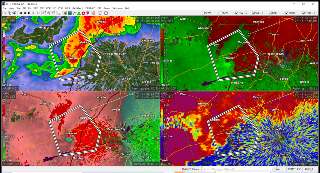
There were other tornadoes that cropped up throughout the afternoon in several states, including Mississippi, Tennessee, Alabama and Georgia. In fact, as this post was coming together, another tornado emergency was issued south of Atlanta, as a large tornado was moving through the town of Newman.
There are already reports of structural damage, and I suspect it will be much worse in the morning. The storm did dissipate before it reached Fayetteville, Georgia, but Tyrone and Peachtree City almost certainly received damage as well. The tornado moved through after midnight, local time, so many residents were probably caught unaware.
In comparing today’s storms to those of St. Patrick’s Day, the biggest change was the tornados’ ability to hit population centers. There were a couple of more individual storms, and the tornadoes will likely be measured as being stronger, but when it comes down to it, today, we were unlucky.
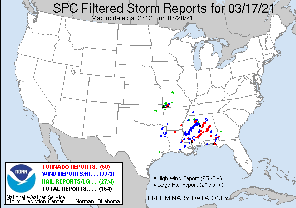
The high risk of severe weather was well advertised over St. Patrick’s Day in the southeast, and on Friday in the Carolinas. Fortunately, there was no loss of life, and only a few injuries. One might look at the dire forecast and the relatively good news, and think that the forecast was a bust. While it was certainly a good result, the forecast wasn’t really a bust.
A high risk severe thunderstorm day asserts that there is a significant risk of many tornado reports, including long track tornadoes. There were 50 reports of tornadoes, and the tracks through Mississippi and Alabama, as well as a cell that started in Florida and ended in Georgia, show that, even if twisters touched down and lifted several times, these were long tracking supercells.
There were tentative moments. One of the cells generated near Tuscaloosa, scene for a devastating tornado 10 years ago, but fortunately, remained to the south and east of town. It did reach EF2 levels, and caused damage in nearby Moundville, but avoided the larger population centers.
Another cell — actually, a couple of cells following the same track — started rotating over and near Selma, which is west of Montgomery. Not only did the tornadoes they produce miss the population center of Selma (they did cause injuries outside of town) but as the storm held together, it remained to the north of Montgomery, and even larger town.
This day of storms, I believe, would have been remembered differently entirely if that storm to the north had shifted a few miles to the north, and the storm to the south took a slightly different track in any number of the passes over Selma. The forecast was a good one, but residents of Mississippi, Alabama and the surrounding region simply got lucky.
A little over a week ago, we took a look at the weather in Sacramento, which was at the tail end of a nasty couple of days. The culprit was a broad area of low pressure that would end up moving into the southern Plains and bringing a tornado outbreak to the southeast late this week. Things bounced back very quickly after one last murky day on Thursday. The high temperatures jumped more than 10 degrees from Thursday to Friday, setting up a nice weekend. Accuweather grabbed a narrow victory. Actuals: Thursday – High 58, Low 36 Friday – High 69, Low 35
Last Wednesday, when we were looking at Colorado Springs, we checked out the radar. Flurry activity stayed in the Denver area, north of the Palmer Divide. This topographic barrier slowed precipitation, which was mighty, in the Denver area through the end of the week, as a nother round of wet weather descended upon the Plains. Mind you, it eventually did bring Colorado Springs quite a bit of nasty weather, but that was on the weekend, after the forecast period expired. There was a little spritz light wintry weather on Friday night, but not the deluge expected for late week by some outlets. Temperatures stayed much cooler than anticipated, which is a flaw that can show up in the Rockies. That’s just the way it goes. The Weather Channel was the top forecast, but it was rough. Actuals: Thursday – High 38, Low 25 Friday – .03 inches of mixed precip, High 32, Low 27
As readers of this site, you may be interested to learn that my second book is scheduled to be released on March 30th. It is a spiral bound quick guide, featuring a lot of photos for reference. It will be easily portable, and full of all the information you need on the go.
And if you do want the deeper information on how the atmosphere works, remember, you can still buy the original Field Guide!
Let’s head on out to California to finish this busy day of posting.
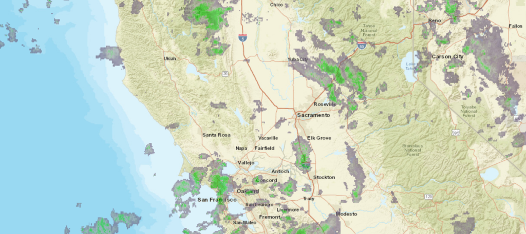
At 653PM, PT, Sacramento was reporting a temperature of 44 degrees with mostly cloudy skies. A broad trough aloft was contributing to a smattering of valley rain and mountain snow across the western US, generally from the Rockies to the coast. The surface low showed circulation centered off the coast from Point Arena, northwest of San Francisco Bay. Aside from that, surface features were ill defined. The trough responsible for the inclement weather is bringing cooler air to the region as well. It’s axis is directed southwest to northeast, and that will slow its progression to the east. Unbound to the south, it will sink away a bit from Sacramento through the end of the week, leading to sunnier skies on Friday. Sacramento will still be within a general trough, however, and temperatures will remain cool, even if skies clear. Tomorrow – Overcast with rain through the day, High 58, Low 40 Friday – Sunnier and warmer, High 65, Low 37
TWC: Tomorrow – Partly cloudy. High 59, Low 39 Friday – Mainly sunny. High 67, Low 37
AW: Tomorrow – Times of sun and clouds High 57, Low 39 Friday – Intervals of clouds and sun High 67, Low 34
NWS: Tomorrow – Mostly cloudy, then gradually becoming sunny High 58, Low 40 Friday – Sunny, High 66, Low 37
WB: Tomorrow – Mostly cloudy in the morning, becoming partly cloudy, High 58, Low 40 Friday – Patchy Frost in the morning. Sunny, Warmer, High 66, Low 36
WN: Tomorrow – Partly cloudy, High 58, Low 40 Friday – Sunny, High 66, Low 37
FIO: Tomorrow – Partly cloudy throughout the day. High 59, Low 40 Friday – Clear throughout the day. High 66, Low 37
I’m the only one saying that there will be rain tomorrow. I think we all agree that clouds and murk will linger in Sacramento, and snow will plaster the mountains outside of town.
When you are working with clear skies in the Plains, you might expect to have a pretty easy forecast. Even with low pressure moving towards Topeka late in the forecast period last week, it was the first day of our forecast period that proved toughest. Those clear skies brought temperatures all the way down to 29 degrees by Wednesday morning, which was a solid 5 degrees colder than anyone prognosticated. The Weather Channel was the best aside from that blip that was on everyone’s ledger, as they accurately had the warmest high temperature forecast. Actuals: Wednesday – High 72, Low 29 Thursday – High 72, Low 30gradec