
The high risk of severe weather was well advertised over St. Patrick’s Day in the southeast, and on Friday in the Carolinas. Fortunately, there was no loss of life, and only a few injuries. One might look at the dire forecast and the relatively good news, and think that the forecast was a bust. While it was certainly a good result, the forecast wasn’t really a bust.
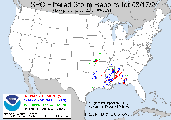
A high risk severe thunderstorm day asserts that there is a significant risk of many tornado reports, including long track tornadoes. There were 50 reports of tornadoes, and the tracks through Mississippi and Alabama, as well as a cell that started in Florida and ended in Georgia, show that, even if twisters touched down and lifted several times, these were long tracking supercells.
There were tentative moments. One of the cells generated near Tuscaloosa, scene for a devastating tornado 10 years ago, but fortunately, remained to the south and east of town. It did reach EF2 levels, and caused damage in nearby Moundville, but avoided the larger population centers.
Another cell — actually, a couple of cells following the same track — started rotating over and near Selma, which is west of Montgomery. Not only did the tornadoes they produce miss the population center of Selma (they did cause injuries outside of town) but as the storm held together, it remained to the north of Montgomery, and even larger town.
This day of storms, I believe, would have been remembered differently entirely if that storm to the north had shifted a few miles to the north, and the storm to the south took a slightly different track in any number of the passes over Selma. The forecast was a good one, but residents of Mississippi, Alabama and the surrounding region simply got lucky.