Lynchburg, Virginia

We are headed smack dab into the middle of Virginia for our forecast. There is snow on the ground in this part of the country, but what can be said about Virginia this weekend?

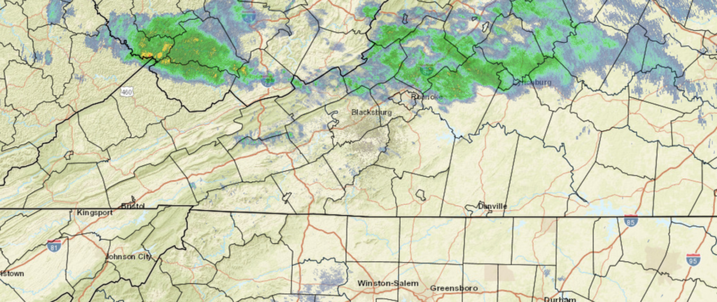
At 1054AM, ET, Lynchburg was reporting a temperature of 47 degrees with mostly cloudy skies. The overcast is ahead of a warm front associated with a vast area of low pressure in the Plains. Moisture will be more plentiful on the western side of the Appalachians, but some light drizzle is still possible this afternoon. When skies clear this afternoon, expect a significant warm up, which will only continue on Saturday.
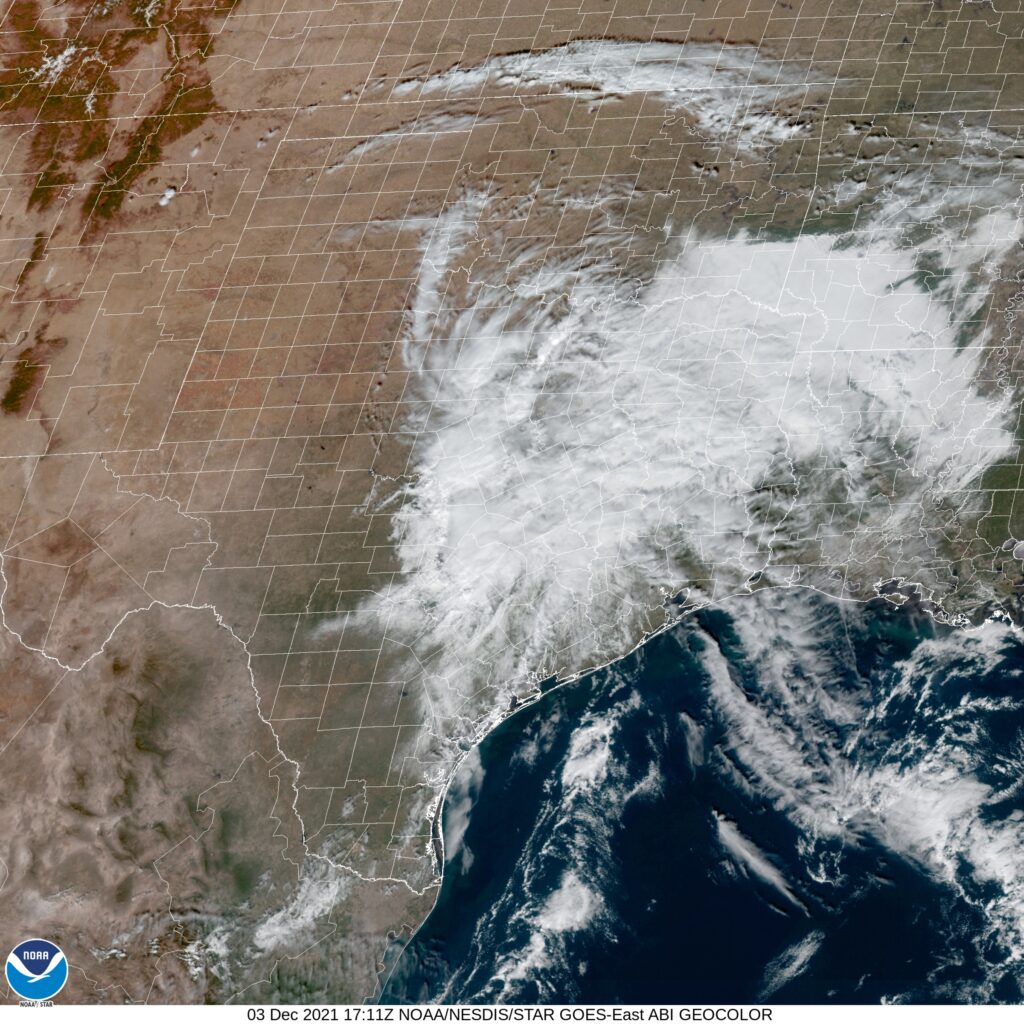
The cold front will arrive with vigor on Saturday evening. While strong and severe weather is anticipated in the mid-Mississippi Valley today and tonight, the teeth will be taken out of the storm. There could be some strong winds, but the continuing elongation of the trough and the disruption caused by the mountains will ensure that the storm won’t have the tornado or heavy rain threat seen today. The front will move through quickly, leading to a cool, dry day on Sunday. The upper trough is going to flatten through the Mid-Atlantic, and in conjunction with post-frontal downsloping, the temperature drop will be blunted, but the dry air will remain.
Tomorrow – Showers and thunderstorms in the evening, High 71, Low 47
Sunday – Clearer and cooler, High 54, Low 39

TWC: Tomorrow – Cloudy skies with periods of rain later in the day. Thunder possible. High 70, Low 48
Sunday – A mainly sunny sky. High 53, Low 39

AW: Tomorrow – Mostly cloudy and becoming windier with the temperature near the record of 71 set in 2015; a shower and t-storm in the afternoon High 70, Low 49
Sunday – Mostly sunny and cooler High 53, Low 39

NWS: Tomorrow – A chance of showers before 4pm, then showers and possibly a thunderstorm between 4pm and 5pm, then showers after 5pm. Some of the storms could produce gusty winds. High 69, Low 48
Sunday – Sunny, High 52, Low 36

WB: Tomorrow – Cloudy. Slight chance of a thunderstorm in the afternoon. Some thunderstorms might cause gusty winds in the afternoon. High 66, Low 49
Sunday – Sunny, High 51, Low 39

WN: Tomorrow – Mostly cloudy with light showers and isolated storms, High 68, Low 39
Sunday – Sunny, High 52, Low 36

FIO: Tomorrow – Rain in the evening. High 69, Low 51
Sunday – Clear throughout the day. High 52, Low 32

Looks like that warm frontal rain has reached Lynchburg since this forecast began! The real weather story for the region will be tomorrow afternoon with a cold front, from a system that is causing big problems in the middle of the country right now.

The Prize

Many of the nation’s top weather institutions are in Norman, outside of the city of Oklahoma City. The Storm Prediction Center, National Severe Storms Laboratory and the University of Oklahoma, one of the best schools for meteorology in the world all call Norman home. Most meteorologists I know have, at some point, passed through the area. This is a forecast that strikes to the heart of meteorology, and an extra pat on the back for the winners for the day, Weatherbug (not headquartered in Oklahoma City, by the way). The verification was quite remarkable, in it’s own way. The Saturday high was lower than all forecasts, while the low was at the top end of forecasts. On Sunday, the reverse was true, with a warmer high than anyone called for, and a colder low. Still and all, a decent enough forecast, and we have not embarrassed ourselves on these hallowed grounds.
Actuals: Saturday – High 56, Low 48
Sunday – High 75, Low 43

Grade: B-C

Asheville, North Carolina to Jacksonville, North Carolina

North Carolina doesn’t get enough respect as a large state. It will take over 5 hours over 367 miles. We will go at a pace of 66.3mph from the mountains to the sea, and see all that North Carolina has to offer.

Asheville, North Carolina

North Carolina will be on the southern flank of a ridge that is drifting into the Atlantic, just off shore from New York, and the tail of a cold front will trigger some clouds across North Carolina. If we get out of the mountains early enough, we could see some fog. It should clear up after Hickory, but clouds will remain present across North Carolina for the remainder of our drive, and only more so as we sink further south and towards the coast in Jacksonville. Hope we drove to the right one.

Jacksonville, North Carolina

Asheville, North Carolina

Asheville is one of the more surprisingly attractive vacation destinations, thanks both to the setting in the Blue Ridge Mountains, and destinations like the Biltmore Mansion. Hopefully, the weather holds for any off season visitors.

At 1154AM, ET, Ashville was reporting some haze, with clear skies and a temperature of 60 degrees. High pressure centered over the Great Lakes was the name of the game, but lingering moisture from the Gulf was interacting with a surface feature in Alabama, bringing about some clouds south and west of the southern Appalachians, which was generating western slope overcast and a large whorl south of Asheville, but no real concerns.
All eyes will be on a still developing trough and surface low in the northern High Plains. A cold front will be come well evident west of the Appalachians, from Lake Erie to Arkansas by tomorrow night, and the rotational energy with the system will eventually bring some warmer conditions and scattered clouds on Sunday and Monday as the boundary stages. As the parent low starts to track poleward and the front encounters the mountains, it will begin to deteriorate. Still, a little bit of rain is expected on Monday evening, with some cooling after the forecast period.
Tomorrow – Breezy and mostly cloudy, High 54, Low 46
Monday – Partly cloudy early, with increasing clouds and rain late, High 61, Low 44

TWC: Tomorrow – Intervals of clouds and sunshine High 55, Low 43
Monday – Overcast with rain showers at times. High 63, Low 47

AW: Tomorrow – Mostly cloudy and cooler High 55, Low 44
Monday – Mostly cloudy with a bit of rain in the afternoon High 66, Low 41

NWS: Tomorrow – Mostly sunny (late rain), High 56, Low 44
Monday – Showers likely, mainly between 11am and 4pm. Mostly cloudy, High 64, Low 39

WB: Tomorrow – Mostly sunny in the morning, then becoming partly cloudy (late rain) High 53, Low 46
Monday – Showers likely, High 63, Low 39

WN: Tomorrow – Partly cloudy, high 55, Low 43
Monday – Mostly cloudy with light showers likely, High 63, Low 47

FIO: Tomorrow – Partly cloudy throughout the day. High 56, Low 44
Monday – Overcast throughout the day. High 65, Low 35

Those lows on Monday are going to be non standard, and places like The Weather Channel will be hurt by not having hourly forecasts out that far. If the clouds don’t fill in ahead of the front tomorrow like we expect, there is some real bust potential. Today, the satellite imagery looks more interesting than it probably is.

Back on track

The verification for Kennewick sure was humbling. It wasn’t the case in San Antonio, however, as departing clouds and a little bit of exiting drizzle left the city with mild, almost cool conditions for a couple of days… just like we expected. Temperatures were a hair lower than what was in the forecast, but the high of 71 both Sunday and Monday was pretty close to what we all expected. The Weather Channel and Accuweather claimed a shared victory.
Actuals: Sunday – High 71, Low 43
Monday – High 71, Low 40

Grade: B-C

Oklahoma City, Oklahoma

The first forecast for December is on its way, and we’re going to one of the weather capitals of the country.

At 1053AM, CT, Oklahoma City was reporting a temperature of 67 degrees. There was a splotch of clouds over the Oklahoma City airport, but the rest of the region was seeing clear skies. Lingering moisture associated with the return flow at the back end of previous ridge led to morning haze and fog across the Gulf Coast, but generally laminar flow over the country is aiding in the development of weak low pressure in Texas. It is propelling clouds and moisture north into Oklahoma.
As the strong seasonal jet, presently along the Canadian border begins to trough in the Canadian Prairies, a deep area of low pressure will emerge in the northern High Plains and the extra agitation will potentially trigger some light rain later in the day on Saturday. As the feature shifts to the east into the Great Lakes, the clouds will clear in order to lead to a warmer afternoon, but the beginning of next week will be on the colder side.
Tomorrow – Mostly cloudy with a little bit of drizzle, High 62, Low 45
Sunday – Warmer and clearer late, brisk in the evening. High 71, Low 44

TWC: Tomorrow – Mostly cloudy. Slight chance of a rain shower. High 59, Low 46
Sunday – Sunny. Becoming windy late. High 73, Low 46

AW: Tomorrow – Mostly cloudy and cooler High 61, Low 46
Sunday – Breezy in the morning; otherwise, mostly sunny and milder High 73, Low 46

NWS: Tomorrow – Mostly cloudy, High 59, Low 49
Sunday – Sunny, High 73, Low 47

WB: Tomorrow – Mostly cloudy, cooler, High 58, Low 48
Sunday – Mostly sunny, High 72, Low 47

WN: Tomorrow – Mostly cloudy, High 59, Low 49
Sunday – Mostly sunny, High 72, Low 47

FIO: Tomorrow – Mostly cloudy throughout the day. High 62, Low 46
Sunday – Clear throughout the day. High 72, Low 45

The temperature forecast was all over the map, model wise, but forecast outlets really converged. Here is a look at this afternoon’s satellite imagery, showing clouds on the way.

A quiet December kick off

Temperatures aren’t incredibly warm right now, but they are above normal across the country, as our strong seasonal jet lies along the Canadian border, ensuring Arctic air is held at bay, and continues to force the various systems moving through North America into Canada, with little impact across the US.

There is a pretty decent area of low pressure coming together over Ontario tonight, preparing to move through New England over the next 48 hours, with some precipitation coming, including snow in the Green and White Mountains, but not down near the coast. In early December, a Canadian area of low pressure could reasonably be expected to bring about snow and wind, but without cold enough air in place, and a redirect towards the north thanks to the jet’s position, the storm will be more nuisance and less of a concern.

We will be graced by this mellow start to December only for a couple of days. The long range forecasts, while still on the warm end, suggest that more precipitation is going to be on it’s way for the rest of the month. Eventually, normal temperatures are expected for the northern part of the US, which means, of course, chilly winter weather. The snow is coming, and a white Christmas is probably on it’s way for a lot of people that are used to it.

More immediately, a trough will start to emerge in the second half of the weekend, with a strong, deep trough emerging in the center of the country. Cold air will spill into the Mississippi Valley, while low pressure and an active cold front start sweeping through the eastern third of the country to start next week. It is more likely that this is our first really good taste of winter, because the wet weather moving into New England isn’t really it.

Enjoy these quiet days, because things are going to get a bit more wintry as the month moves forward.