12:35AM: With all this dry line talk, about storms erupting along and east of it, the forgotten part is that dry side. Well here it is: The dewpoint right now in Albuquerque is 21. Dry line indeed.
Updates 8/3
9:05PM: Check out the reports with this storm near the Oklahoma Panhandle. 2.5″ hail, 65kt winds. Because the largest cities in the path of this storm aren’t really that large, this qualifies as a “slight” risk.

Updates 8/2
10:05PM Not unlike yesterday, there are severe storms, particularly along the front range of the Rockies, and specifically, there are several reports along I-80 in southern Wyoming. This makes sense, as there are observing stations along the highway, and also, there just aren’t that many other people in Wyoming.

Updates 8/1
7:35PM – It’s definitely a late summer pattern out there. The jet pattern is non-existent which leaves the most constant boundary the dry line. Sure enough, there is at least a marginal risk in the High Plains every day from today through the weekend, and probably to start the week ahead.
9:37PM – There has been a tornado watch in the Colorado/Nebraska/Wyoming tri-state. High Plains tornadoes are typically photogenic, visible for miles, and isolated from human populations. No tornadoes have been observed tonight, but there has been 2.5 inch hail around Cheyenne. Hope you have a hail deductible, chasers!
Updates 7/30
11:49PM – I’m happy to say I should get through this update without a power outage, however I will note that every night for the last several, there has been rain along the Minnesota and Iowa border. As you might expect, there are river flood watches and warnings across the state of Iowa.
San Luis Obispo, California
We are on our way to Point Conception, north of LA for this forecast. There were tsunami advisories south of SLO today, which is not something I have seen on an NWS alert map in the past.
At 656PM, PT, San Luis Obispo was reporting clear skies and a temperature of 64 degrees. There was a brisk onshore flow, keeping things comfortable west of the Coastal Range, though it was in the mid-90s on the other side of the mountains.
There is a jet streak over central California ensuring onshore flow will be maintained with some vigor, however of greater note is the low clouds lurking offshore. Point Conception is prime territory for morning low clouds and fog, and each of the next to days should feel the impact of the Marine Layer.
Tomorrow – morning clouds and fog, High 76, Low 55
Friday – Morning clouds, clearing, High 76, Low 55
TWC: Tomorrow – Partly cloudy skies High 74, Low 54
Friday – Sunshine along with some cloudy intervals. High 75, Low 56
AW: Tomorrow – Clouds giving way to sun High 77, Low 56
Friday – Mostly sunny and nice High 78, Lo 56
NWS: Tomorrow – Patchy fog before 11am. Otherwise, cloudy through mid morning, then gradual clearing, High 75, Low 55
Friday – Patchy fog before 11am. Otherwise, cloudy through mid morning, then gradual clearing High 76, Low 55
WB: Tomorrow – Low clouds and fog in the morning then sunny. High 81, Low 58
Friday – Low clouds and fog in the morning then sunny. High 80, Low 59
WN: Tomorrow – Partly cloudy, High 75, Low 55
Friday – Partly Cloudy, High 76, Low 55
CLI: Tomorrow – Sunny, High 74, Low 56
Friday – Sunny, High 74, Low 58
Wow, one degree different from the NWS forecast. We’ll all feel pretty silly if we are a ways off. Satellite shows the lingering clouds offshore.

Modesto, California to Danville, Illinois
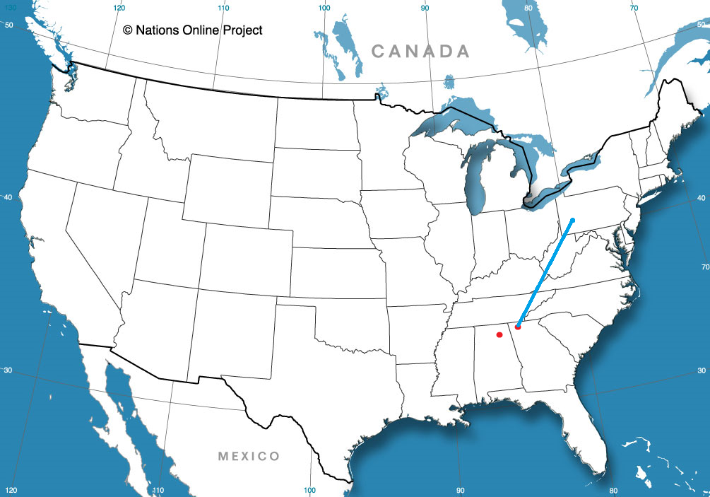
We are headed towards the middle of the country, on a drive that will spend quite a bit of time on I-80. It will take 4 days to cover this ground, because America is a big country. Expect a pace of about 69.4 mph, which is pretty great, actually. Hopefully, the weather will cooperate as well.
DAY ONE (Thursday)

There is some signal that there will be an active monsoon, spreading as far west as the Cascades and northern Sierras. Not really the monsoon, I guess, at that point, but it will follow a similar diurnal pattern. I wouldn’t expect it to occur far enough or early enough in California to be a concern, and the drive through Nevada will be generally featureless, both with the weather and the man made structures. The day will end in Welcome, as we approach the Utah border.
DAY TWO (Friday)
The monsoon will make more sense on Friday, following the Front Range in Colorado and Wyoming, which we will approach on our second day on the road. We’ll make it to the Akal rest area west of Laramie, and we may see a spot of rain at the end of the day. Nothing overwhelming, surely, and definitely not anything that will substantially slow us down.
DAY THREE (Saturday)
The impulse coming away from the front range, the one that we approached at the end of our Saturday drive, will lurk through central Nebraska for much of our Saturday drive. There will be patchy clouds, some spots of rain, heavy at times, and an isolated thunderstorm. We will take our turn off of I-80 in Lincoln and make it to Palmyra for the night. By that point, those showers and storms should be ramping up, and we may be in for quite the stormy evening.
DAY FOUR (Sunday)
I didn’t realize when I was looking ahead to this forecast that we were spending none of our time on Sunday on I-80, and in fact, very little of our time will be on an interstate. We will make it across northern Missouri on US 36, but we will leave the weather in Nebraska (and maybe a bit in Iowa). The trough bringing storms to Palmyra will stall and provide some steadier rain for the eastern part of the Cornhusker state. By the time we have reached St. Joseph and turned on to 36, we will have reached the end of the precipitation for our journey. We will cross Missouri in mostly sweltering sunshine before crossing the Mississippi in Hannibal and finally slicing through the heart of Illinois to reach our destination in Danville. It will feel summery to end the weekend.

Danville, Illinois
Danville lies along the Indiana border, south of Chicago, and deep inside of corn sweat country. Are you ready to swelter?
At 355PM, CT, Danville was reporting a temperature of 91 degrees with clear skies. Importantly, dewpoints were in the low to mid 70s across the regions, making things even more uncomfortable. Lower level forcing is driving a bit of surface development, which is initiating in the High Plains. The moisture that crops up here will then track along the southern edge of a ridge that has emerged over the north central part of the US. There is, as a result, a marginal risk of severe weather for the area tomorrow. There is weak forcing but unstable air. Things may unfold quickly.
If things proceed as current longer range models indicate, storms will arrive in Danville and linger into the overnight hours, before exiting town in the predawn of Thursday. If this is another derecho, as have been frequent of late, don’t be surprised if the onset is earlier than currently indicated. Fortunately, the ridge is going to continue to squash further south. It isn’t necessarily enjoying the benefit of cold air, but the air is dryer, and Thursday afternoon, at the very least, will be pleasant.
Tomorrow – Rain in the afternoon, with strong thunderstorms possible overnight, High 92, Low 72
Thursday – Early morning thunderstorms, with gusty winds, then much more pleasant, High 79, Low 66
TWC: Tomorrow – A mix of clouds and sun early, then becoming cloudy later in the day. A stray thunderstorm is possible High 91, Low 70
Thursday – Scattered thunderstorms in the morning, then cloudy skies late. High 75, Low 66
AW: Tomorrow – Warm and humid with variable cloudiness; a couple of heavy thunderstorms in the afternoon; storms can bring flash flooding and damaging winds High 89, Low 70
Thursday – Periods of rain and a thunderstorm in the morning; mostly cloudy and humid; heavy downpours can reduce visibility and cause ponding on streets and highways High 74, Low 68
NWS: Tomorrow – 40 percent chance of showers and thunderstorms after 1pm. High 89, Low 72
Thursday – A 50 percent chance of showers and thunderstorms before 1pm. High 77, Low 65
WB: Tomorrow – Patchy fog in the morning. Sunny with a slight chance of showers and thunderstorms in the morning then partly sunny with a chance of showers and thunderstorms in the afternoon. High 93, Low 74
Thursday – Mostly cloudy. A chance of showers and thunderstorms in the morning. High 76, Low 66
WN: Tomorrow – Partly cloudy with a chance of storms, High 89, Low 72
Thursday – Mostly cloudy with a chance of storms, High 78, Low 65
CLI: Tomorrow – Thunderstorm, High 91, Low 71
Thursday – Thunderstorm, High 76, Low 63
Clearly, whatever happens in Danville this week is going to have a real impact. Expect better sleeping this later this week, central Illinois. Satellite with a few clouds by St. Louis before the sun goes down.

Pretty chilly, actually
We put together a forecast for Phoenix in the middle of the month, and we were looking for a very hot couple of days in Arizona. Fortunately for local residents, it was colder than expected by all outlets on both the 14th and 15th! That’s right, it was only 106 on both days! The Weather Service won the day.
Actuals: July 14th, High 106, Low 91
July 15th, High 106, Low 88
Grade B-C
Update 7/28
10:02PM – This update is a little delayed! Mid post, Victoria-Weather lost power and didn’t get it back until this morning.
This is the radar imagery as a pair of lines moved through Minnesota, notably the Twin Cities and around Sioux Falls and Sioux City. There was a big gap between the lines that curiously lined up with the core of a Moderate Risk issued by the SPC earlier in the day.