Janesville, Wisconsin

Janesville is on the Illinois border, just north of Beloit. I know it best as a constant source of road construction, seemingly every time I attempted to drive between my parents’ in Minnesota and school in Indiana.

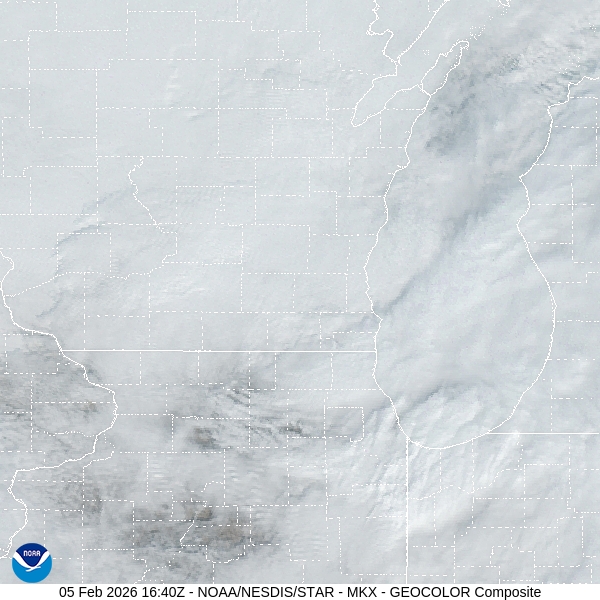
At 245PM, CT, Janesville was reporting a temperature of 34 degrees with overcast skies. An undercutting boundary beneath strong low pressure in western Ontario was found at the back edge of the local overcast, and at the leading edge of advancing warm air. That boundary was over central Iowa, however, and the warmest push of air is not expected to make it to Janesville before nightfall, and a weak cold front will arrive to chase it out by sunrise tomorrow.
The boundary will be quick moving, and bring just a dusting of snow through the morning, with clearing skies coming by afternoon. The clearing trend will continue with high pressure developing in the western Great Lakes. The clear skies will still feature some brisk northwest winds, but warmer weather is not far behind this forecast period.
Tomorrow – Early snow flurries, then clearing, High 36, Low 12
Saturday – Mostly sunny, High 20, Low 5

TWC: Tomorrow – Cloudy early then partly cloudy and windy later in the day. A few flurries or snow showers possible High 36, Low 16
Saturday – Mostly sunny early then increasing cloudiness later in the day High 25, Low 7

AW: Tomorrow – A couple of flurries early in the morning; otherwise, mostly cloudy and breezy; watch for slippery spots early High 36, Low 14
Saturday – Turning cloudy and cold High 22, Low 4

NWS: Tomorrow – A 50 percent chance of snow, mainly before 8am. Cloudy, then gradually becoming mostly sunny, High 34, Low 14
Saturday-Increasing clouds, High 21, Low 5

WB: Tomorrow – Cloudy with chance of light snow in the morning then mostly cloudy with scattered flurries in the late morning and early afternoon. Partly sunny late in the afternoon High 36, Low 14
Saturday – Colder. Sunny in the morning then becoming partly sunny. High 22, Low 6

WN: Tomorrow – Mostly cloudy with scattered snow showers, High 35, Low 14
Saturday – Partly cloudy with snow showers, High 21, Low 5

CLI: Tomorrow – Heavy Snow showers, High 37, Low 10
Saturday – Mostly cloudy, High 21, Low 4

Hang in there, Janesville! The snow is a set back, but warmer weather is coming next week!

Gadsden, Alabama to Ames, Iowa

We are off on another trek, this time lasting a day and a half, covering 884 miles. The first day will be the full day, and will conclude after about 532 miles. The pacing on this trip will be 66.5mph, which is pretty good! Let’s hope for dry roads!

DAY ONE (Monday)

Gadsden, Alabama

The weather is clear now, what with our cavalcade of wintry weather finally clearing out of the southeastern US. The interstates are getting cleared first, but the beginning of our drive, through hard hit Tennessee, specifically Nashville, which is still trying to thaw. It’s snow in Kentucky and southern Illinois, but that is a lot easier to push to the side of the road. Our drive will end in Wentzville, Missouri, a western suburb of St. Louis.

DAY TWO (Tuesday)
Behind the ridge that is bringing the pleasant weather to the Mississippi Valley is the next upper level trough, which I need to assure you is not like the last two. Nevertheless, some precipitation will be coming together as we get started on Tuesday morning. There may be a few flurries between Wentzville and Hannibal, but it certainly isn’t an all day affair for us, driving into Ames, which will be at least warmer than it has been.

Ames, Iowa

Ames, Iowa

We’ve spent a great deal of our time and energy focused on the southeastern US, so we get to get a taste of something different this evening.

At 453PM, CT, Ames was reporting a temperature of 32 degrees with overcast skies. This is following a band of light snow that was related to a clipper moving through the Upper Midwest. An area of high pressure is moving through the Canadian Prairies, with a bit warmer air flowing under the upper level feature.
The Canadian ridge will sink back to the south tomorrow, and there is a chance for a band of flurries Late tomorrow, but the advancing area of high pressure will ensure that the day won’t be completely snobound.
Tomorrow – Increasing clouds with late flurries, High 31, Low 16
Tuesday – Mostly sunny,High 25, Low 14

TWC: Tomorrow – A mix of clouds and sun early, then becoming cloudy later High 31, Low 20
Tuesday – Partly cloudy. High 28, Low 18

AW: Tomorrow – Intervals of clouds and sun High 30, Low 18
Tuesday – Periods of clouds and sunshine High 26, Low 17

NWS: Tomorrow – Partly sunny, High 30. Low 17
Tuesday – Partly sunny, High 28, Low 17

WB: Tomorrow – Partly sunny. High 31, Low 22
Tuesday – Partly sunny. High 26, Low 18

WN: Tomorrow – Partly Cloudy, High 29, Low 17
Tuesday – Partly Cloudy, High 28, Low 16

CLI: Tomorrow – Overcast, High 33, Low 17
Tuesday – Mostly cloudy, High 28, Low 10

Here’s the radar imagery for Iowa, with our warm front already through town. Well, through the Hawkeye State, actually.

Raleigh, North Carolina to Gadsden, Alabama

We are taking a one day trip, but it is going to be a slog through part of the world that has been the focus of wintry conditions this season. I can’t imagine that this bodes well for the journey. It is presently allotted for about 8 hours and 525 miles, covering 65.8mph. I hope. We just have to try to trust the local DOTs.

Fantastic news for anyone looking to travel in the Southeast: no new precipitation is expected for that particular stretch of land. Unfortunately, it won’t be getting any warmer, either. The chilly conditions, on top of a half foot of snow, in a part of the world that doesn’t get a chance to plow very often suggests that whatever snow fell over the last couple of days is probably still going to be there. The snow had a difficult time clambering over the higher terrain in the Appalachians, There is at least light snow as far to the west as Atlanta, where the eastern suburbs still have an inch or two on the ground. Fortunately, the roads will dry up to conclude the dry. Expect some tentative drivers joining the road with increasingly impatient drivers. The traffic should start to wind down for that last drive. Maybe then we can appreciate all that sunshine.

Gadsden, Alabama

Updates 1/31

5:13PM: An interesting feature of the ongoing storm activity in the Southeast for the second weeeekend in a row is the absence of precipitation in the northern Plains. It’s cold, but it’s cold on top of a half inch of snow in some places. No changes in the near future, either.

9:57PM: OK, I take it back a little bit. There might be an additional quarter to half inch in some places tonight, particularly in Minnesota. And, actually, it will ride a warm front, so temperatures might be livable tomorrow. Melt some ice.

A more targeted storm is incoming.

My friends, I regret to inform you that, once again, in the Carolina Plains, it will be snowing again. That is the bad news. The good news is, there is a reason that I specifically called out this particular area.

The polar vortex is still parked over eastern Canada, which means a persistently active, and most importantly, a continually cold stretch of time for America east of the Rockies. Later this week, the upper level structure is going to rotate further to the south and a bit to the east, which is going to do two important things. One, it is going to get even colder for an unfortunate chunk of the country. Additionally, it is going to push the storm track south and a bit to the east.

The trough, in its motion, is going to have improved vorticity, and an increased capacity for cyclogenesis. What does that mean? It means low pressure is going to develop towards the southern base of the trough. As I said, this feature is going to be shifting further south and a bit to the east, which means the surface area of low pressure is going to develop south and a bit east of where the weekend storm went. Offshore.

This does mean the storm going to be stronger, with a deeper central pressure. This means that despite less moisture, and a narrower focus for the precipitation,, the wind will drive most of the issues. There are blizzard watches out for the Piedmont, but there aren’t any snow accumulation forecasts for even double digits that I have seen. And absolutely no forecasts for ice.

So even with the limited precipitation relative to last week, the nature of this storm is that it will be stronger at it’s heart, colder and windier. Snow that falls will be heaviest in the Carolinas and Virginia, but there may be a few flakes along the immediate coast from New Jersey through Massachusetts, but there too, the big threat is blustery wind.

The winter weather will pick up overnight tomorrow in the Carolinas and Virginia. The wind will peak Saturday night, and will be worst in the Outer Banks. The cold will move back in and continue to linger. The good news is, this storm i narrower geographically, and won’t have ice. But it will be windy. Stay safe, and tie down the lawn chairs.

Updates 1/29

6:00pm: The storm last weekend was such a good measuring stick for how we can be affected by weather depending on where you live. The East Coast is returning to normal: plows are clearing the roads fairly easily, and kids aren’t getting more days off of school. In places like Nashville, so much ice brought down branches and power lines, and recovery will be measured in months. Right now, it’s just going to be an :effort to stay warm.

8:42PM: The upper level trough is beginning to rotate into the southeastern US, bringing a pool of cold air with it, and also pushing a head some flurries, which are extending along a line from the western Dakotas, south to Nebraska and at a sharp eastward angle towards Cincinnati. Keep an eye on that crook and where it ends up. That will be the center of our problems this weekend.

Primed and ready

As I noted in our discussion of the massive storm that came through last weekend, the region had aready been preconditioned, and was chilly, particularly for this part of the world. We saw that in the forecast for Rome, Georgia, which we issued the weekend before, and saw temperatures dive into the 20s, which is unusual in Georgia! Generally, though, there were a couple of times, the high temperature on Monday the 19th, and especially the low temperature on Tuesday the 20th, that were warmer than expected by a few degrees, Accuweather was the warmest forecaster on those two times, and came through with the win. Sidebar: I’m just now realizing our last two verifications were for Florence and Rome. How continental!
Actuals: January 19th, High 50, Low 27
January 20th, High 46, Low 27

Grade: C

Updates 1/27

2:05PM: We get to enjoy a bit of peace and quiet, albeit without power and buried under snow in a big chunk of the country, but at least the weather will be quiet! Of course, we have our next system moving into the Pacific Northwest right now, and there are signals at the end of the week that another storm could be brewing in the southeast. Can’t be as bad as the last one though, right?

Right?

7:59PM: The snow and whatnot is done (whatnot is doing some heavy lifting there), but the cold is not. Anyone who has gone through winter knows that when the snow is on the ground, the temperatures have a much tougher time warming up.

Brr.

11:46: And now for something completely different: Freezing conditions extend deep into Florida tonight.