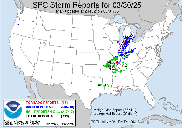
1153PM Where did those thunderstorms end up bringing severe weather to? As you may recall, we were looking at an enormous area of severe weather risk leading into the day.
A little towards the northern end of the risk area. For fun, here is the map for today.
Arkansas doesn’t get thought about as a severe weather center, despite the location between both the original Tornado Alley and the Dixie Alley. It can be a stormy place, Arkansas, when March rolls around. It sure has been today.
At 953 PM, CT, Pine Bluff was reporting a temperature of 77 degrees with fair skies. Thunder was beginning to depart Arkansas, however the cold front hadn’t yet reached Pine Bluff. Little Rock’s dew point was dropping, and there were waning showers and isolated storms between Pine Bluff and the capital. The severe storms have moved out, however. After the boundary moves through, an initial pool of cooler air will spill in, and be reinforced by a shallow upper level ridge. This will scuttle a dramatic cooldown, and the next major storm developing in the Plains will kick off a warm up by mid week. Tomorrow – Clearing and cooler, High 70, Low 53 Tuesday – Mostly sunny, High 77, Low 45
TWC: Tomorrow – A mainly sunny sky (Early storms). High 71, Low 53 Tuesday – Partly cloudy skies. High 77, Low 46
AW: Tomorrow – Cooler and less humid with sunshine (early storms); High 71, Low 56 Tuesday – Sunny to partly cloudy and pleasant High 78, Low 47
NWS: Tomorrow – Mostly cloudy through mid morning, then gradual clearing (early storms) High 69, Low 53 Tuesday – Mostly sunny, High 77, Low 46
WB: Tomorrow – Sunny, (early rain) High 69, Low 59 Tuesday – Mostly sunny. High 76, Low 49
WN: Tomorrow – Mostly sunny (early storms), High 69, Low 55 Tuesday – Mostly sunny, High 75, Low 47
CLI: Tomorrow – Sunny (early rain) High 70, Low 54 Tuesday – Partly cloudy High 77, Low 48
My forecast counterparts all have a chance for more storms tonight, but it has really quieted in Arkansas (though a cell popped up near Stuttgart just as I finished). The roughest weather in Arkansas today was found up by Jonesboro and Memphis.
We’ve started off busy this spring, with several rounds of severe weather, marked by organization and intensity. While storms, particularly tomorrow, stand to be nasty at times, the remarkable thing is how broad the coverage of this weather is expected to be.
The enhanced risk covers over 240,000 square miles, and features, initially a hail threat in the southwestern portion of the risk early in the day, transitioning to some supercells with a tornado threat centralized along the Ohio downriver from Louisville to the Mississippi south to Greenville, Mississippi. Ultimately, the cells will merge into lines, and strong wind in the southern Great Lakes will be the threat.
The upper level pattern features a broad trough over the middle of the country, setting the stage for broad instability. A couple of short waves at the upper levels will produce more focused inclement weather, and the bullseyes in different areas.
As with any nasty weather, it all depends on where it hits. The biggest thing about this system is that it is big, but the top end energy isn’t going to match some of the storms we’ve seen earlier this month. The geographic scope of the weather means it will be a headline maker, as well as a headache maker for anyone trying to travel.
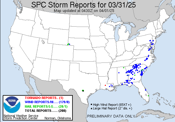
More rough stuff is expected on Monday along the East Coast. The weather, again, looks to be weaker, but more people, more travelers will be impacted than even tomorrow.
The Florida Panhandle is an area that gets busy this time of year with students of all types spending their spring break in an easily accessible stretch of beach. One thing they don’t want in Fort Walton Beach or other spots is what they saw from the 19th to 20th. A splash of rain and morning lows that dropped into the 40s when all was said and done. Go home, tourists! Weatherbug got this non-welcoming forecast the best, losing points for having a dry forecast. Actuals – 19th, High 72, Low 64 20th, .04 inches of rain. High 70, Low 46
It’s getting warmer which means it is getting closer to road trip season. This three day trek might follow the 1,797 mile path of someone returning from spring break. We will average 66.5 miles an hour and 532 miles a day, though we are really going to pack it in — 11 hours — on Saturday.
DAY ONE (Thursday)
Lake Havasu City, Arizona
This drive is one of beauty if you are just there to enjoy the scenery, as the sun will be shining, but as this is a weather blog, it may not offer the excitement we are hoping for. Alas, it is the Desert Southwest, and you get what you pay for. It will be a bit more interesting if you take in the entirety of the region, however. Low pressure in the Gulf of Alaska and a festering system in south Texas will squeeze our route, even bringing some clouds towards Albuquerque as we conclude our first day, though I-40 will stay clear.
DAY TWO (Friday) That sluggish feature in south Texas is going to start wandering east, and remain out of our path, but we would be wise to note what is causing this wander. A strong area of low pressure emerging in the lee of the Rockies will start directing traffic across the Plains, and will bear watching all weekend. Our trip to Oklahoma City will be pretty uneventful, however, which is a nice thing to say when severe weather looms.
DAY THREE (Saturday) It’s not going to organize terribly quickly, our large, troublesome area of low pressure. This means we don’t need to worry about a severe outbreak during our drive, but we will some isolated showers east of Rolla, MO, and more scattered showers and isolated thunderstorms north of Springfield as we get closer to the center of the system. Rockford will probably have rain, if not when we arrive, then soon.
Made some updates on the back end tonight, so I hope there are no interruptions, because I am a meteorologist, and not an HTML guy! We’ll find out together!
At 1054PM, CT, Rockford was reporting a temperature of 33 degrees with mostly fair skies. Temperatures will continue to cool below freezing overnight, given the clear skies, however a batch of precipitation is rotating through eastern Iowa on the far western periphery of the influence of a broad upper level trough. These showers will not impact Rockford tonight, but a few clouds would arrest the overnight cool down, albeit momentarily. Flow tomorrow will be from the northwest. A weak feature in the southern part of Hudson Bay will work up a few more clouds, particularly by tomorrow afternoon, with some light rain possible during the early morning on Thursday. This will be the signal that an unseasonably warm ridge is sliding into the area, and ushering in a warm end of the week. Tomorrow – Increasing clouds. High 57, Low 30 Thursday – Early morning rain, otherwise mostly cloudy, High 59, Low 38
TWC: Tomorrow – Intervals of clouds and sunshine. High 57, Low 29 Thursday – Overcast (early rain). High 58, Low 40
AW: Tomorrow – Partly sunny; a warmup is on the way High 56, Low 29 Thursday – Cloudy with a bit of rain; breezy in the afternoon High 54, Low 39
NWS: Tomorrow – Mostly sunny, (Early rain) High 55, Low 31 Thursday – A 40 percent chance of showers, mainly before 1pm. High 55, Low 40
WB: Tomorrow – Partly cloudy High 56, Low 32 Thursday – Mostly cloudy. A chance of showers mainly in the morning High 55, Low 43
WN: Tomorrow – Partly cloudy with a light wintry mix, High 55, Low 31 Thursday – Mostly cloudy with scattered showers, High 55, Low 41
CLI: Tomorrow – Light rain showers High 56, Low 31 Thursday – Overcast High 58, Low 38
When I say a warm start to the weekend, I’m talking “close to 80” warm, which is very nice in March. It won’t last, of course, as it never does. A lot of forecasts for rain on Wednesday, despite a pretty unblemished satellite.
It truly is an honor to say that we were there when we forecast for rain in central California, and it verified accurately. Indeed, our forecast in Hanford did verify with a half inch of rain on Monday and Tuesday, which most outlets had figured correctly. The biggest area of difference was the low temperature on Tuesday, which was a few degrees warmer than anticipated. All told, a pretty good forecast, considering the location and the fact that there was actually weather. Victoria-Weather and WeatherNation combined for the victory. Actuals: Monday .46 inches of rain, High 60, Low 46 Tuesday .02 inches of rain, High 60, Low 44
3:19PM – Low pressure in Eastern Canada is quit occluded, enough so the original low has kicked off a secondary trough breezing through the western Great Lakes. There is a little rain in Minnesota and Iowa, and some strong gusts as well.
7:02PM – The system moving through the country this weekend is evocative of an Alberta Clipper. It starts today in the northern Rockies and will get stronger as it dives southeast, where the best shot for severe storms will crop up on Sunday. And yes, there will probably be some snow, up on the Canadian border and Northern Great Lakes.
What are the signs of spring that you look for? If you are a normal person, you are likely looking for that first robin to land in your front yard, or for the daffodils to start blooming. If you are a meteorologist or weather super fan, you are on the look out for big, multifaceted storms rumbling through the middle of the country. I can’t speak to the daffodils in your neighborhood, but we have certainly seen those big storms.
Storms at the beginning of the week were particularly nasty. An EF-4 tornado struck Diaz, Arkansas, while 43 were killed across several states, including 12 in Missouri. Rolla and Poplar Bluff were among the towns to sustain significant damage. Strong storms continued through the Southeast and Mid Atlantic with more tornadoes striking from Louisiana to Alabama, and to the north in Illinois and Indiana. There were also gusty winds and large hail. Given that so many storms struck overnight, an the tornado count was as high as it was, the death toll certainly could have been higher.
The storms have been large enough that they showed up in the long term guidance well in advance of the storm. There were outlooks for severe weather in the 4-9 day SPC outlooks for this storm, as well as the smaller storm early this week (which brought 3 separate small tornadoes to Gary, Indiana!). There is a threat again on Sunday of this weekend for more rough stuff in the Tennessee Valley, though the threat is not as great as these past two rounds. It’s a sign of how pronounced the upper air pattern is. A sure sign of spring.
I noted that these storms were multifaceted. Not only did the storms bring severe weather of the thunderstorm variety, but also of the winter variety, with blizzard conditions coming with both storms in parts of the Upper Midwest. The dynamics of the storm lead to narrow bands of heavy snowfall, and as significantly, strong winds that impacted visibility. Again, this is the nature of spring.
Most people aren’t meteorologists, however, and the larger part of the universe is awaiting warm weather, and I assure you, it is coming. The beginning of the season is a great time to look at the CPC outlook for the next three months. Great news for the sunseekers, because no part of the country, aside from western Alaska, should expect below normal temperatures.