9:32PM It’s a quiet night across the country. The bulk of he warnings on the national map are temperature related, which is not what one expects to see on April 8th.
11:20PM Another sign that the seasons are changing. A fairly organized complex of fronts is going to move out of the Plains and into the Great Lakes through the next 48 hours. Why is this unusual? Because it’s not really going to DO anything. How can we tell it will move through? It will be partly cloudy and 75 or so tomorrow in Omaha (after lower 60s today). On Wednesday and Thursday, it will be partly cloudy and 65.
It was a good month for Weatherbug. I am a huge fan of their updated interface, and I guess you dress good you feel good, because their month of forecasting was very successful. They had half of the overall victories in the month, which is a pretty good way to win the forecaster of the month award. It’s a turnaround after a slow start to the year, but it was well earned. Congrats!
We watched with Memphis as they anticipated severe weather last week, and we will begin this week on the opposite side of the state. What to expect in Johnson City?
At 1138AM, ET, the Tri-Cities were reporting a temperature of 57 degrees with overcast skies and lingering fog. The elongated band of at times heavy and flooding rain that has brought havoc to the mid-South and Ohio Valley has now reached the Appalachians, and is starting to depart East Tennessee. The day will be rainy in Virginia, and a little bit of vorticity will come to the southern part of the line of showers, slowing the line down a bit and bringing some moisture back into the Tri Cities. Rain isn’t expected for the rest of the day, however overcast and fog will struggle to retreat. A post frontal trough at the back side of the broader area of low pressure will mean more fog and clouds tomorrow morning, but temperatures that aren’t as cool as they could be, given the post frontal air mass. An area of high pressure will develop across the region through the afternoon tomorrow, and will hold intact through Wednesday. It will be warmer, thanks to the sun shining a bit more, but a warm air mass will be harder to come by. Tomorrow – Morning fog and cloudy, clearing late, High 49, Low 35 Wednesday – Mostly sunny, High 62, Low 30
TWC: Tomorrow – Some clouds in the morning will give way to mainly sunny skies for the afternoon. High 51, Low 36 Wednesday – Plentiful sunshine. High 65, Low 28
AW: Tomorrow – Mostly sunny and cold High 51, Low 38 Wednesday – Warmer with plenty of sunshine High 63, Low 30
NWS: Tomorrow – Mostly sunny, High 51, Low 34 Wednesday – Widespread frost before 7am. Otherwise, sunny, High 64, low 26
WB: Tomorrow – Mostly sunny. High 49, Low 39 Wednesday – Sunny. High 63, low 32
WN: Tomorrow – Partly cloudy, High 50, Low 36 Wednesday – Mostly sunny, High 64, Low 29
CLI: Tomorrow – Sunny, High 50, Low 35 Wednesday – Sunny, High 62, low 26
There is some pretty consistent forecast temperatures. The sure sign of a sunny forecast in the spring time. It sure isn’t sunny right now.
It was a fairly rainy stretch in Elmira as we began April, as it has been from the Plains to the mountains of the Eastern US, but there was a little bit of texture to the story on Wednesday and Thursday. A warm front brought about a quarter inch or rain over the two days, but perhaps of more pertinence, it also brought a temperature spike of 25 degrees. Spring tried moving into New York this week, and the Weather Service and WeatherNation were there for it. We are in April, and it was the first victory share of the year for WeatherNation. Actuals: Wednesday, .16 inches of rain, High 51, Low 28 Thursday – .03 inches of rain, High 76, Low 49
It’s Friday, at least. Will it be a good weekend at the Pennsylvania Capitol?
At 556PM ET, Harrisburg was reporting a temperature of 65 degrees with overcast skies. A sharp upper level trough in the Plains was producing another severe outbreak in the Mid South, with a truncated rain shield following a warm front to western Pennsylvania. More entrenched is a ridge on the East Coast, pushing the mid and upper 60s to near the New York border. The upper level pattern will be slow to move, but at the surface, the instability will attempt to continue northeastward. Redevelopment will occur in the southern Plains, and showers moving to central Pennsylvania will lose potency, and severe weather is not anticipated. The entire system will inch further east through Sunday. Tapping into the Gulfstream moisture will make for a bit more rain than Saturday will provide. Rain may not clear out on Sunday, slowing the cool down. Tomorrow – Mostly cloudy with scattered showers, High 58, Low 49 Sunday – Some heavier showers, lighter late, High 56, Low 47
TWC: Tomorrow – Cloudy with a few showers. High 60, Low 52 Sunday – Overcast with rain showers at times. Thunder possible. High 55, Low 46
AW: Tomorrow – Cloudy with a little rain High 62, Low 53 Sunday – Cloudy with occasional rain and a thunderstorm High 60, Low 45
NWS: Tomorrow – Rain likely, mainly after 4pm. Cloudy, High 63, Low 54 Sunday – Rain High 60, Low 44
WB: Tomorrow – Rain likely. High 59, Low 54 Sunday – Rain. High 55, Low 44
WN: Tomorrow – Cloudy with light rain likely, High 62, Low 53 Sunday – Cloudy with light rain, High 58, Low 45
CLI: Tomorrow – Light rain showers, High 61, Low 51 Sunday – Light Rain Showers, High 60, Low 45
There isn’t going to be a heavy cold pool to clear the murk out of Harrisburg, despite how strong the jet streak overhead is. That jet trough just won’t get moving through town this weekend, though it does lead to a pretty dreary weekend. Look how close the rain is to town, and it isn’t even moving in until tomorrow!
Pine Bluff was among the towns that endured severe weather this week, and as it happens, they are within a tornado watch in a Moderate Risk area again right now. When we put together a forecast there for the beginning of the week, it was the beginning of a needed 2 day interregnum. There was one more splash of rain before sunrise on Monday morning, but both Monday and Tuesday were relatively cool, and definite winners for fans of spring. Clime was also a winner, with a very good forecast, and the good sense to leave the chance of rain in the forecast for Monday, unlike some forecasters. I should note, Pine Bluff and the nearby environs did avoid the worst of the weather on Wednesday. It ended up initiating just to the northeast of the area Actuals: Monday – .08″ of rain, High 71, Low 54 Tuesday – High 76, Low 48
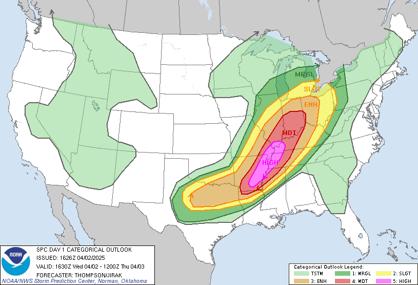
As I noted in our look ahead earlier today, we have a high risk for severe weather in the mid-Mississippi Valley this afternoon and evening. We can go through full severe seasons without a high risk, so this is notable.
Storms are beginning to crop up. There have been some severe storms along the cold front, including tornadoes from Illinois to Arkansas, but all eyes are on the Memphis area, where supercells are popping up in west Tennessee and northern Mississippi, including a confirmed twister near Jackson, TN. Follow along with ABC 24’s live stream
We are starting April, and a very active March is being parlayed into a swift beginning to April. As I post this schedule, know that there is a high risk, a rare designation, for severe storms today in a part of the country that has been battered all spring so far. The high risk extends from Vienna, Illinois to El Dorado, Arkansas, and includes Memphis, Jonesboro and Pine Bluff. Stay vigilant.
Harrisburg, Pennsylvania
Johnson City, Tennessee
Albany, Georgia Road Trip from Tucson, Arizona to Albany.
Elmira is just north of the Pennsylvania border, and usually just to the south of the Lake effect bands of snow. Hopefully in April, we are done with Lake effect!
At 653PM ET, Elmira was reporting a temperature of 41 degrees with clear skies. There was a brisk north wind, flowing toward a boundary connecting a feature in the Gulf Stream to a large feature in the Plains. The evidence of the boundary, however was a wisp of clouds down around Norfolk, and a temperature gradient that sharpened near the Mason-Dixon Line. The boundary will function as a warm front by tomorrow, lifting into the Mid-Atlantic and bringing some significant rain through the area tomorrow evening. Elmira will be within the warm sector by Thursday morning, but overcast and scattered showers will damper some of the enjoyment. Action along the front will be found most prominently much further downstream along the cold front, which will move sluggishly through Elmira in the evening, and won’t result in a precipitous drop off in temperature in the evening. Tomorrow – Increasing clouds with rain, heavy at times in the evening, High 47, Low 23 Thursday – Cloudy, warmer with some showers, High 71, Low 42
TWC: Tomorrow – Cloudy with occasional showers for the afternoon. High 49, Low 27 Thursday – Rain showers early with overcast skies later in the day. High 73, Low 43
AW: Tomorrow – Considerable cloudiness, becoming breezy in the afternoon with a couple of showers late High 48, Low 24 Thursday – Cloudy, breezy and warmer with a couple of showers and a thunderstorm, mainly early in the day High 77, Low 44
NWS: Tomorrow – Showers likely, mainly after 4pm. Mostly cloudy High 52, Low 26 Thursday – Showers likely and possibly a thunderstorm. Cloudy High 75, Low 46
WB: Tomorrow – Mostly cloudy. Rain showers likely in the afternoon. High 52, Low 30 Thursday – Showers likely. High 72, Low 42
WN: Tomorrow – Mostly cloudy with a light wintry mix possible, High 51, Low 27 Thursday – Mostly cloudy with light showers and isolated storms, High 73, Low 46
CLI: Tomorrow – Rain showers, High 49, Low 24 Thursday – Rain Showers, High 76, Low 44
Man, distractions and life got in the way, and this one took a while to finish up. But here is the initial satellite showing the band of clouds around Hampton Roads.
Nobody ever notices the low temperatures, and when they start to get warmer. You might look at our forecast for Rockford last week. We knew that Friday and potentially Saturday were going to be sweltering by late-March standards, but our forecast covered Wednesday and Thursday. Believe me when I tell you that the warm up had started on Thursday, though the high temperatures went the other direction. That drop in temperature was due to the overcast and little bit of rain that fell, but the overcast and rain were beckoned by an advancing warm front. The low temperature was in fact 17 degrees warmer on Thursday than Wednesday. Very sneaky. Weatherbug had the top forecast for the day. Actuals: Wednesday – High 57, Low 29 Thursday – .05 inches of rain, High 55, Low 46