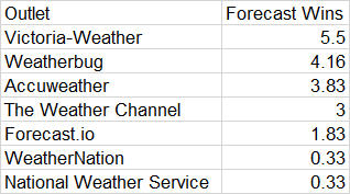
The beginning of May has certainly been warm here in Minneapolis! This comes after an April that was all over the map in so many ways. It took a great degree of forecasting skill to have the multifaceted forecasts that April required. Weatherbug won the month, and should fully embrace their victory.
Today is the 10th anniversary of a major tornado outbreak, which caused death and destruction across the southeast, most notably when a tornado hit Tuscaloosa, including the campus of the University of Alabama. This time of year has no shortage of such anniversaries.
This year, fortunately, there aren’t any major severe weather outbreaks on the immediate horizon. Model guidance is in lockstep over the next few days, so that can be taken with some degree of certainty that there isn’t a major event before the end of April.
That’s not to say it won’t be stormy. Every increment of the forecast features a little wave, producing showers and thunderstorms rolling through the country, particularly from the Central Plains to the Ohio Valley southward. It’s not always the same wave, and no area is going to be relentlessly active for the next several days, but there will certainly be many active radars in the south central and southeastern US through the end of the work week.
Beyond nationally calm Saturday, divergence begins to settle in. Timing and placement are askew for the various computer guidance that meteorologists have available. Going beyond 5 days for a forecast is never generally as accurate as one might hope, but for a lot of the country, Sunday and the early part of next week are all over the map.
One thing that is in concert, is that none of the model maps are quiet. There is always something going on. A broad trend like that can be relied upon, moreso than a forecast for a particular location. That means the country can expect to see a lot going on in early May, even if we can’t confidently say what we should expect quite yet. With the anniversaries of Tuscaloosa, Moore and so many other coming up this time of year, “action” is not something everyone should look forward to.
Every ten years, weather averages are reconsidered and updated. Daily high temperatures, low temperatures and precipitation are now based on the most recent 30 years, reflecting the most recent information in our ever changing climate. In addition to the daily changes, monthly and seasonal changes are also instituted.
Hurricane seasonal averages were updated, replacing the 80s with the extremely active 2010s. Now, an average season will see 14 named storms, with 7 hurricanes, up 2 and 1 from the previous averages, according to the National Oceanic and Atmospheric Administration. This is has a lot to do with the active years early in the past decade, and especially the last several years, which were busier than even the new normal years.
There is something to be said about the warming of the north Atlantic, but also, the El Nino pattern, which was more prevalent in recent years. Somewhat surprisingly, the eastern and central Pacific didn’t have any revision to their annual averages. The Atlantic also didn’t see an increase to the major hurricane forecast.
Satellite data and naming conventions really were revolutionized in the 90s. Improved satellite data will, as a result, not be a factor in future changes to averages, but they may have led to some change in this update. Hurricane season, officially, begins on June 1st, and we are coming off the busiest season of all time.
I’ve definitely said it before, and it was proven again this month. The Weather Channel comes through during months with terrible weather. They always seem to have their best forecasts when they are sought after the most, the sports equivalent of performing when the lights are brightest. Congrats to TWC for coming through when people counted on them most.
I posted last week about the high risk of severe weather that turned into a couple of long track supercells that fortunately avoided major population centers. Today, we weren’t as lucky.
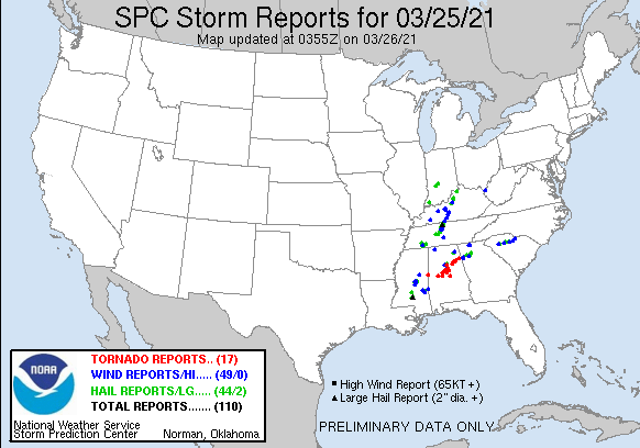
There were a few tornadic storms, but one storm in particular will be remembered for a long time. Here are the storms that have been reported today, most notably a long track, large tornado that trekked from West Blocton, Alabama to Pelham, through the south side of Birmingham, and on to Ohatchee, where 5 people lost their lives, before the rotation fell apart just inside the Georgia state line.
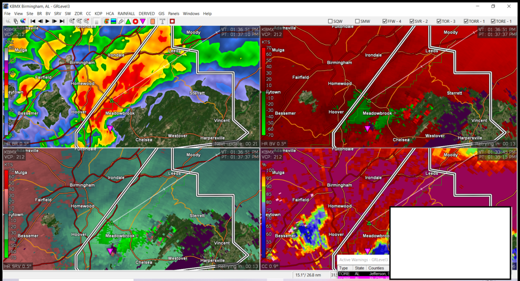
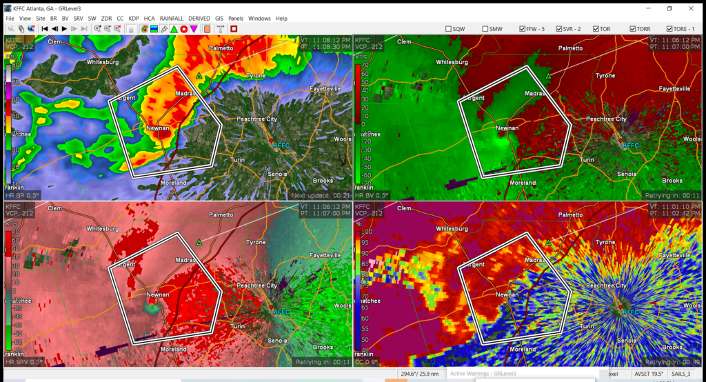
This storm was strong enough that is showed up very evidently on radar. Note the red dot in the bottom left display, near Meadowbrook. The storm had crossed I-65 and was currently within a tornado emergency, suggesting a confirmed, large tornado in a populous area.
That pink triangle in the four displays reflects the rotation well. Remarkably, this tornado was on it’s way toward a subdivision where local meteorologist James Spann lives. He found out on air that his home suffered heavy damage as tornado passed nearby.
There were other tornadoes that cropped up throughout the afternoon in several states, including Mississippi, Tennessee, Alabama and Georgia. In fact, as this post was coming together, another tornado emergency was issued south of Atlanta, as a large tornado was moving through the town of Newman.
There are already reports of structural damage, and I suspect it will be much worse in the morning. The storm did dissipate before it reached Fayetteville, Georgia, but Tyrone and Peachtree City almost certainly received damage as well. The tornado moved through after midnight, local time, so many residents were probably caught unaware.
In comparing today’s storms to those of St. Patrick’s Day, the biggest change was the tornados’ ability to hit population centers. There were a couple of more individual storms, and the tornadoes will likely be measured as being stronger, but when it comes down to it, today, we were unlucky.
The high risk of severe weather was well advertised over St. Patrick’s Day in the southeast, and on Friday in the Carolinas. Fortunately, there was no loss of life, and only a few injuries. One might look at the dire forecast and the relatively good news, and think that the forecast was a bust. While it was certainly a good result, the forecast wasn’t really a bust.
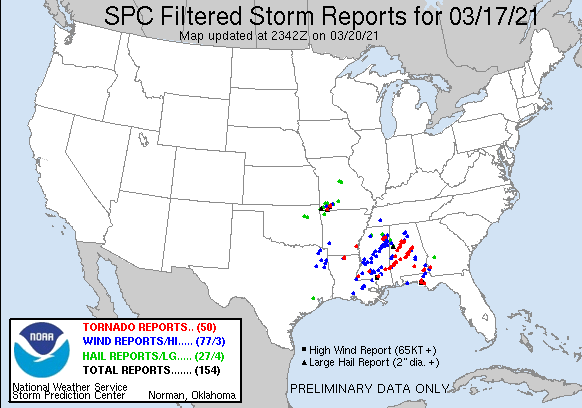
A high risk severe thunderstorm day asserts that there is a significant risk of many tornado reports, including long track tornadoes. There were 50 reports of tornadoes, and the tracks through Mississippi and Alabama, as well as a cell that started in Florida and ended in Georgia, show that, even if twisters touched down and lifted several times, these were long tracking supercells.
There were tentative moments. One of the cells generated near Tuscaloosa, scene for a devastating tornado 10 years ago, but fortunately, remained to the south and east of town. It did reach EF2 levels, and caused damage in nearby Moundville, but avoided the larger population centers.
Another cell — actually, a couple of cells following the same track — started rotating over and near Selma, which is west of Montgomery. Not only did the tornadoes they produce miss the population center of Selma (they did cause injuries outside of town) but as the storm held together, it remained to the north of Montgomery, and even larger town.
This day of storms, I believe, would have been remembered differently entirely if that storm to the north had shifted a few miles to the north, and the storm to the south took a slightly different track in any number of the passes over Selma. The forecast was a good one, but residents of Mississippi, Alabama and the surrounding region simply got lucky.
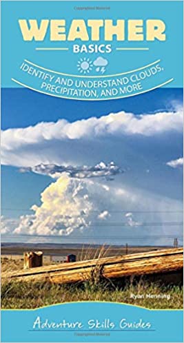
As readers of this site, you may be interested to learn that my second book is scheduled to be released on March 30th. It is a spiral bound quick guide, featuring a lot of photos for reference. It will be easily portable, and full of all the information you need on the go.
And if you do want the deeper information on how the atmosphere works, remember, you can still buy the original Field Guide!
Victoria Weather finally got our forecasting groove back, giving you more regular weather updates, and we sure picked the right month to do that. Victoria-Weather cruised to victory, and have a stranglehold on the overall lead for the year. Thanks, February! (Note, Forecast wins posted now only reflect the total wins for the year)
The series of systems moving through the Tennessee Valley, towards the Mid-Atlantic, have generally been rainy, but not particularly threatening. Not individually, at least.
The problem is that the stream of moisture took a path through the hills of eastern Kentucky and West Virginia. While steady rain anywhere will end up being problematic, it’s a much shorter trip to disaster in the terrain of the central Appalachians. Take a look at the video from WTHR showing the fast water flowing through the streets of Hurricane, West Virginia, west of Charleston
Snow is inconvenient, challenging and dangerous, while the ice being seen from Mississippi to New Jersey is destructive, but the enduring cold is proving the most difficult and costly disaster, particularly in Texas. Power grids are failing thanks to a lack of winterization amid a cold snap that is breaking record books across the Plains (for example, Oklahoma City saw the coldest temperature recorded since before Oklahoma was even a state).
As you can see with the first image, the cold spell will alleviate over the course of the next week. With this particular situation with people freezing in their homes, it’s important to get a little more clarity. It’s nice to know that things will be more comfortable next week, but we still need to get to next week.
Cold weather, though not record breaking, will continue through the day tomorrow before things begin to really alleviate. Temperatures on Friday will remain cold, but temperatures in the afternoon from Oklahoma to Arkansas and southward will start to pop into the 40s, slowed somewhat by all the snow that has fallen.
Temperatures will hit the 50s around Abilene, and the 40s over the Metroplex on Saturday, with above freezing temperatures reaching into Iowa on Sunday. By early next week, 60s will be widespread, with a forecast in the mid 80s for Abilene by next Thursday.
Relief is on its way, and with spring coming up, it seems unlikely that we will revert back to another icy blast again. At least, not this winter.