Over the weekend, there was a report from CBS that labeled lake effect snow as a “snow firehose” and claimed it was very rare. Anyone who lives east or south of the Great Lakes know that this is decidedly untrue. If it WAS true and it happened over the weekend then Rochester would have been in the “overspray” area, collecting only a trace on Friday and 1-2″ on Saturday. Now the wind, that was something, especially on Friday, where they got 30mph gusts. Maybe that was the firehose? Victoria-Weather and the Weather Service collected the top forecast. Actuals: Friday – Trace of snow, High 26, low 22 Saturday – 1-2″ of snow, High 23, low 12
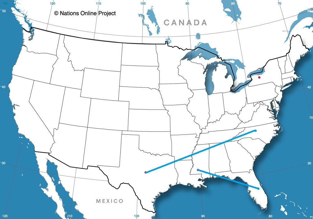
I will admit, that I haven’t done a heck of a lot of driving in the southeastern US, so I don’t have a terribly good concept of just how big the spaces are down there. I am a little surprised, I guess is what I am saying, that Deltona and Hattiesburg are only 610 miles apart, and the drive can be done in just one day. The pace will be a brisk 70mph, owing the fact, I guess, that the only major towns we will bypass are Tallahassee and Mobile, which I guess aren’t beset by traffic.
Deltona, Florida
The weather in Deltona today is quite nice, and there really isn’t anything on its way that suggests that will change for the next 24 hours or so. TYhe start of our drive, therefore, looks pretty great, pretty swift and incident free. Unfrotunately, an area of low pressure developing over Ontario, of all places, is draping a cold front south along the Mississippi River, and it will be inching into the Tennessee Valley as we get going on Monday. Now, the cold front will not reach the coast or I-10 at any point, but the flow feeding the boundary will lead to some afternoon showers and storms from the Florida Peninsula west to Hattiesburg. The shower activity is most possible beyond Tallahassee, but doesn’t become likely until we reach Mobile. The rain won’t last all night, so Hattiesburg should dry up by nightfall. Of course if we want to spend any more time in Hattiesburg than just one night, we might need to make sure our plans are of the “indoor” variety.
Hattiesburg is a part of the Jackson WFO, and in my opinion, this is the best Forecast Office in the country. That aside, let’s see if they are as good at forecasting as they are at web design.
At 1253AM, CT, Hattiesburg was reporting a temperature of 37 degrees with clear skies. The remnants of a strong system are continuing to clear out of the Ohio VAlley, but otherwise, the satellite remains clear east of the Rockies with a surface ridge building from the Gulf to the Great Lakes. There continues to be a broad upper level trough, with the base running zonally along the US-Mexican border the northern Gulf, with an undercutting ridge providing the stability over the continental US. The base of the trough being as far south as it is simply for temperatures to remain a bit below normal, though the clear skies will help make up some of the difference in the afternoon. Tomorrow – Sunny, High 70, Low 34 Sunday – Partly cloudy, High 73, Low 42
TWC: Tomorrow – Generally sunny despite a few afternoon clouds. 71, Sunday – Partly cloudy skies. High 70, Low 44
AW: Tomorrow – Abundant sunshine, High 69, Low 36 Sunday – Partial sunshine High 70, Low 42
NWS: Tomorrow – Sunny, High 69, Low 37 Sunday – Mostly sunny High 71, Low 42
WB: Tomorrow – Sunny, High 69, Low 38 Sunday – Mostly sunny im the morning, then becoming partly cloudy, High 69, Low 44
I have talked about “bright banding” in the past. It is the phenomenon in which snow forms striations on radar, with the brighter returns indicating elongated bands of heavy snowfall. Given the movement patterns of snow storms, these bands tend to linger and usually result in the locations that receive the most snow in a region’s snow event.
What happens, then, if there is only one band of snow in a withering area of low pressure, and it sets up in an area that is otherwise snow free? What this bright band would do is something like what happened earlier this week in Kansas, with a system that moved through the mid-Mississippi Valley, and ultimately became a blizzard in western New York and eastern Canada.
In the end, the snow band was less than 20 miles wide, but in some places more than a foot deep, and came down at a pace that required the closing of I-70 in northern Kansas. Certainly bad luck for the very few people that saw all the snow, but at least they didn’t need to go far to get out of it.
Things are pretty dicey in western New York. Yesterday’s Lake flooding alerts have turned to winter storm and blizzard warnings. My oh my, this should be an interesting forecast.
At 1007AM, ET, Rochester was reporting temperature of 25 degrees, but the thing everyone was surely noticing was the west wind at 33kt and light, wind driven snow. A strong area of low pressure lay over Ontario and Quebec, and on the south end of the system, the brisk west wind is leading to blizzard conditions east of Lakes Ontario and Erie, while Rochester, for the time being, is spared of the worst of this storm. The upper level structure parenting this blizzard is asymmetrical, and that will be it’s undoing. With all the strength off shore, the central low pressure will weaken significantly and the brisk west winds and potential for snowfall will subside this afternoon and through tomorrow. The strong off shore jet will become associated with a laminar jet in the southern US, which will mean cold air will remain in western New York for the next few days. The orientation of the trough will subsequently foster northerly flow, which, while light, will create a fetch off of Lake Ontario that presents the possibility for Lake Effect accumulation in Rochester starting late Friday and lasting through Saturday. Tomorrow – Mostly cloudy with snow returning in the evening, High 28, low 20 Saturday – Persistent, wet snow, High 23, low 15
TWC: Tomorrow – Windy with snow showers in the afternoon High 27, low 21 Saturday – Overcast. A few flurries or snow showers possible High 23, Low 18
AW: Tomorrow – Windy, cold with blowing snow; cloudy with snow at times, accumulating a coating to an inch High 28, low 21 Saturday – Low clouds and cold with a flurry or two High 25, Low 17
NWS: Tomorrow – Snow showers likely, mainly between noon and 5pm, then snow after 5pm. Areas of blowing snow. High 26, Low 20 Saturday – Snow. High 23, Low 17
WB: Tomorrow – Snow showers in the morning, then lake effect snow in the afternoon. Areas of blowing snow. Accumulations of 1-2″ in the most persistent snows. Very windy and cold. High 26, low 21 Saturday – Lake effect snow, High 22, Low 19
WN: tomorrow – Windy with snow showers likely, High 26, Low 21 Saturday – Cloudy with light snow, High 23, Low 21
FIO: Tomorrow – Windy tonight and tomorrow morning. High 27, Low 19 Saturday – Foggy tomorrow night and in the morning. High 25, Low 17
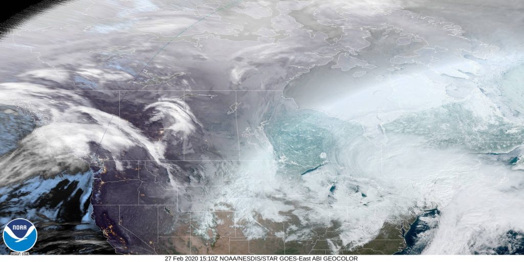
Instead of the radar, like I would normally add when there is precipitation, I have included the satellite imagery from Canada. This is a big area of low pressure stretched across eastern Canada, but it’s not going to last much longer. It’s getting stretched to oblivion as we speak.
Monday turned out to be miserable in central South Carolina. A round of heavy rain moved north and into the Columbia area early on in the day, and didn’t allow Columbia to come up for air at any point. Monday only saw a 3 degree spread from high to low as they collected35 inches of rain through the day. The Weather Channel has continued their solid month with a victory in the South Carolina state capital. Actuals: Sunday, High 62, Low 30 Monday – .35 inches of rain, High 51, Low 38
The Upper Midwest has had a consistent, cyclical pattern of late, generally transpiring over the course of a week or so. Warm over the weekend and through the early part of the week, then the threat of a little bit of precipitation, very cold by Thursday and warming up again for the weekend. It’s happening this week, and it happened last week in Green Bay. Forecasters generally saw that pattern and latched on to it in their forecast. The issue came down to temperature, as forecasters were a couple degrees too warm for where this cycle ended up falling in line. There was a three way tie atop the standings in the end, with the Weather Service, Weather Nation and Forecast.io splitting the winning share. Actuals: Thursday – High 15, Low -7 Friday – High 31, Low 3
The drive from eastern Wisconsin to central South Carolina, if taken today, would be slowed mightily by rain gripping a wide swath of the eastern United States. We will start this two day trek tomorrow, though, so nothing to fear! The drive will cover 1,013 miles, which we will in turn cover at a pace of 65.3mph. The second day will be a little bit shorter, by a half hour or so, and our target distance on Tuesday will be 523 miles. all very manageable, yes?
DAY ONE (Tuesday)
Green Bay, Wisconsin (By Chris Rand)
Low pressure moving through the eastern portion of the country is gradually unraveling today, and will continue to tomorrow. That means that precipitation which was translating quickly earlier in the week is slowing way down. None of it is reaching into Wisconsin, so the drive south towards the Illinois line should be drama free, but when we hit the Windy City, there is a pretty good chance it will be snowing. The snow will continue in this inverted trough south through Indiana, with a gradual change to rain south of Indianapolis. Precipitation won’t be heavy, but it won’t need to be to slow travel down. We’ll reach the eastern suburbs of Louisville, particularly the town of Middletown, by the end of the day.
DAY TWO (Wednesday) The back end of that system will swing to the south overnight. The dry slot will disappear from west of the Appalachians, and the light snow will return to our route, and last through our drive in Kentucky. We will turn south at Lexington and there might be a window of dry air by the time we reach Knoxville, which should last us through the rain shadow afforded by the Smokey Mountains from Asheville to Spartanburg, but the cold front associated with this low will start to redevelop on Wednesday afternoon. More rain will move into Columbia from the south, and will be there to greet us upon our arrival.
The capital city of South Carolina is also home to the University of South Carolina, and will be ground zero to what already seems like an endless election cycle, with this weeks’ pending primary coming to town.
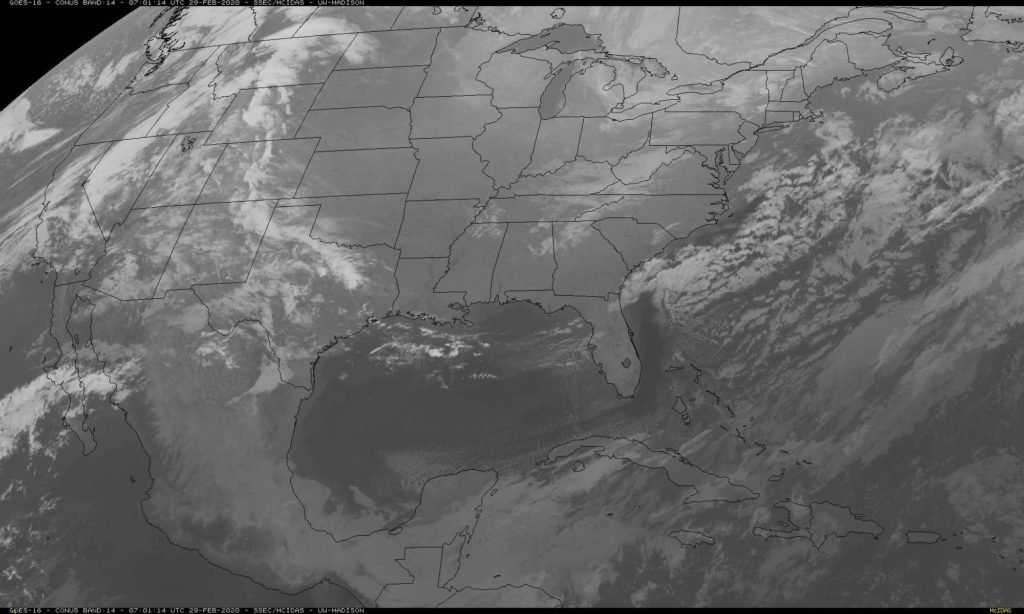
At 1256AM, ET, Columbia was reporting clear skies with a temperature of 31 degrees. High pressure dominated the area, and the clear skies will lead to chilly temperatures for the morning in South Carolina, but the weekend will end pleasantly. Low pressure currently over the Four Corners is going to translate into the central Plains and continue eastward towards the Carolinas. It will deepen over Oklahoma, and develop some well defined warm and cold fronts. The warm front will emerge in central South Carolina by midday on Monday. Heavier showers and a stray thunderstorm will come to town in later in the day as the associated cold front arrives. Tomorrow – Mostly sunny, High 63, Low 28 Monday – Rain through most of the day, starting in the morning, High 58, Low 43
TWC: Tomorrow – Partly to mostly cloudy, High 61, Low 30 Monday – Occasional light rain. High 53, Low 44
AW: Tomorrow – Sun followed by increasing clouds High 60, Low 29 Monday – Cloudy and cool with a touch of rain High 54, Low 45
NWS: Tomorrow – Sunny, High 62, Low 27 Monday – Rain likely, mainly between 9am and 1pm, then showers after 1pm. High 56, Low 45
WB: Tomorrow – Sunny, High 58, Low 32 Monday – Rain likely in the morning then showers in the afternoon, High 53, Low 46
WN: Tomorrow – Mostly sunny, High 62, Low 27 Monday – Cloudy with light rain likely, High 56, Low 45
FIO: Tomorrow – Mostly cloudy throughout the day, High 61, Low 30 Monday – Light rain starting in the morning
Monday is going to be a rainy day in Columbiam but there sure isn’t any sign of it on satellite.
The end of February heading into March can be some of the most active weather times of the year, and the part of the country that contends with that nastiness is the part of the country we will be forecasting for.
Rochester, New York
Hattieburg, Mississippi Road Trip from Deltona, Florida to Hattiesburg
Killeen, Texas
Road Trip from Killeen to Greensboro, North Carolina