Pine Bluff was among the towns that endured severe weather this week, and as it happens, they are within a tornado watch in a Moderate Risk area again right now. When we put together a forecast there for the beginning of the week, it was the beginning of a needed 2 day interregnum. There was one more splash of rain before sunrise on Monday morning, but both Monday and Tuesday were relatively cool, and definite winners for fans of spring. Clime was also a winner, with a very good forecast, and the good sense to leave the chance of rain in the forecast for Monday, unlike some forecasters. I should note, Pine Bluff and the nearby environs did avoid the worst of the weather on Wednesday. It ended up initiating just to the northeast of the area Actuals: Monday – .08″ of rain, High 71, Low 54 Tuesday – High 76, Low 48
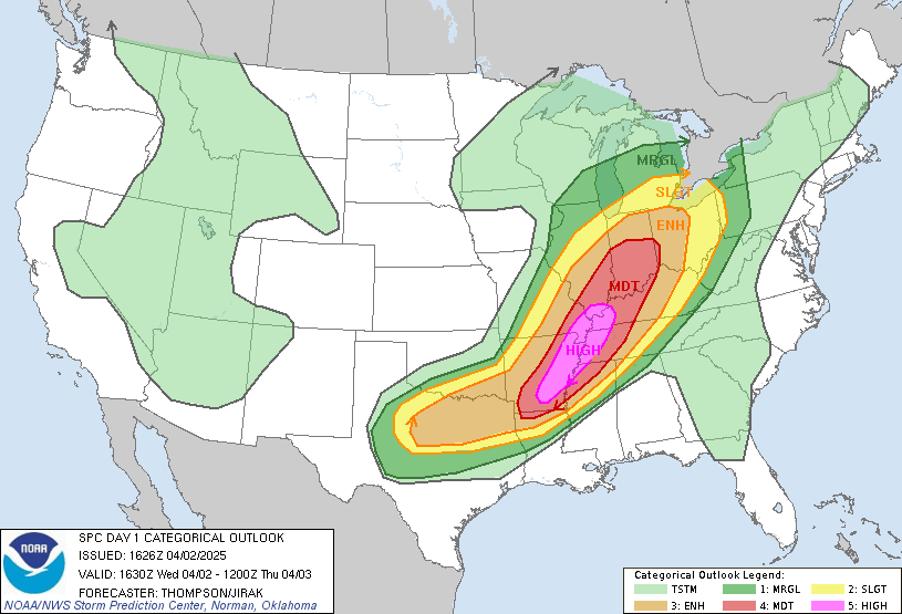
As I noted in our look ahead earlier today, we have a high risk for severe weather in the mid-Mississippi Valley this afternoon and evening. We can go through full severe seasons without a high risk, so this is notable.
Storms are beginning to crop up. There have been some severe storms along the cold front, including tornadoes from Illinois to Arkansas, but all eyes are on the Memphis area, where supercells are popping up in west Tennessee and northern Mississippi, including a confirmed twister near Jackson, TN. Follow along with ABC 24’s live stream
We are starting April, and a very active March is being parlayed into a swift beginning to April. As I post this schedule, know that there is a high risk, a rare designation, for severe storms today in a part of the country that has been battered all spring so far. The high risk extends from Vienna, Illinois to El Dorado, Arkansas, and includes Memphis, Jonesboro and Pine Bluff. Stay vigilant.
Harrisburg, Pennsylvania
Johnson City, Tennessee
Albany, Georgia Road Trip from Tucson, Arizona to Albany.
Elmira is just north of the Pennsylvania border, and usually just to the south of the Lake effect bands of snow. Hopefully in April, we are done with Lake effect!
At 653PM ET, Elmira was reporting a temperature of 41 degrees with clear skies. There was a brisk north wind, flowing toward a boundary connecting a feature in the Gulf Stream to a large feature in the Plains. The evidence of the boundary, however was a wisp of clouds down around Norfolk, and a temperature gradient that sharpened near the Mason-Dixon Line. The boundary will function as a warm front by tomorrow, lifting into the Mid-Atlantic and bringing some significant rain through the area tomorrow evening. Elmira will be within the warm sector by Thursday morning, but overcast and scattered showers will damper some of the enjoyment. Action along the front will be found most prominently much further downstream along the cold front, which will move sluggishly through Elmira in the evening, and won’t result in a precipitous drop off in temperature in the evening. Tomorrow – Increasing clouds with rain, heavy at times in the evening, High 47, Low 23 Thursday – Cloudy, warmer with some showers, High 71, Low 42
TWC: Tomorrow – Cloudy with occasional showers for the afternoon. High 49, Low 27 Thursday – Rain showers early with overcast skies later in the day. High 73, Low 43
AW: Tomorrow – Considerable cloudiness, becoming breezy in the afternoon with a couple of showers late High 48, Low 24 Thursday – Cloudy, breezy and warmer with a couple of showers and a thunderstorm, mainly early in the day High 77, Low 44
NWS: Tomorrow – Showers likely, mainly after 4pm. Mostly cloudy High 52, Low 26 Thursday – Showers likely and possibly a thunderstorm. Cloudy High 75, Low 46
WB: Tomorrow – Mostly cloudy. Rain showers likely in the afternoon. High 52, Low 30 Thursday – Showers likely. High 72, Low 42
WN: Tomorrow – Mostly cloudy with a light wintry mix possible, High 51, Low 27 Thursday – Mostly cloudy with light showers and isolated storms, High 73, Low 46
CLI: Tomorrow – Rain showers, High 49, Low 24 Thursday – Rain Showers, High 76, Low 44
Man, distractions and life got in the way, and this one took a while to finish up. But here is the initial satellite showing the band of clouds around Hampton Roads.
Nobody ever notices the low temperatures, and when they start to get warmer. You might look at our forecast for Rockford last week. We knew that Friday and potentially Saturday were going to be sweltering by late-March standards, but our forecast covered Wednesday and Thursday. Believe me when I tell you that the warm up had started on Thursday, though the high temperatures went the other direction. That drop in temperature was due to the overcast and little bit of rain that fell, but the overcast and rain were beckoned by an advancing warm front. The low temperature was in fact 17 degrees warmer on Thursday than Wednesday. Very sneaky. Weatherbug had the top forecast for the day. Actuals: Wednesday – High 57, Low 29 Thursday – .05 inches of rain, High 55, Low 46
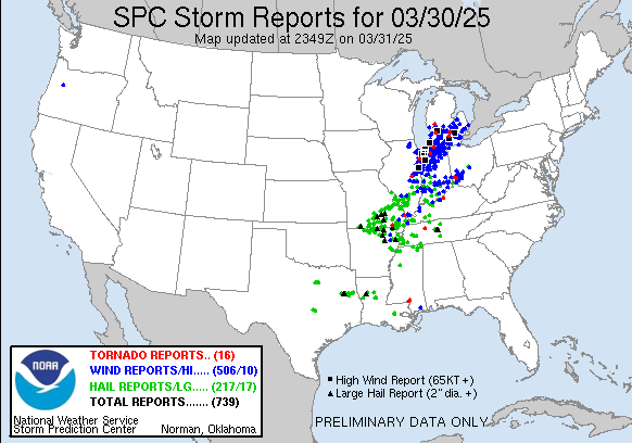
1153PM Where did those thunderstorms end up bringing severe weather to? As you may recall, we were looking at an enormous area of severe weather risk leading into the day.
A little towards the northern end of the risk area. For fun, here is the map for today.