Today we embark on a quick little road trip, just 229 miles separate these 2 cities, and it’ll take barely longer than 1 viewing of Avengers: Endgame to get there. Don’t even need to pack snacks for this trip (but we will anyways)
As a frontal boundary sits over southern Michigan and slowly sags southward during the day, some scattered rain shower activity is expected over northern OH throughout the day. It’ll be a dry start to the trip travelling north from Parkersburg, but the closer we get to the lakefront, the more likely we’ll see a scattered shower or two across our route. Nothing particularly heavy is expected, just the weather being a little annoying.
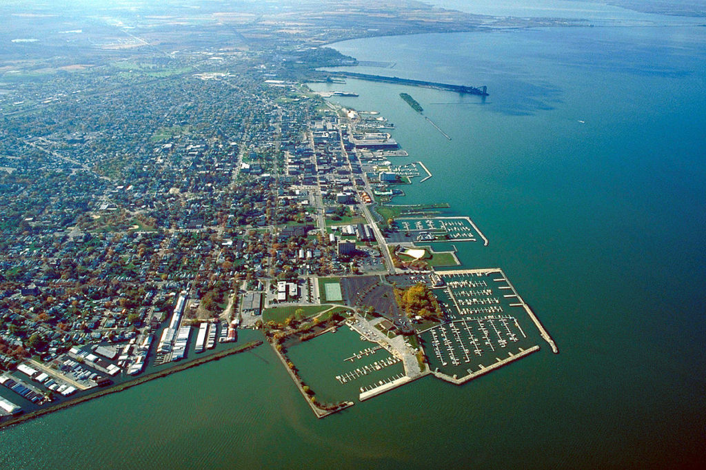
As we start off the workweek, let’s travel to the shores of Lake Erie and see what Sandusky is up to!
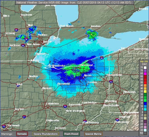
At 1153pm EDT, the temperature at Sandusky, OH was 60 degrees under fair skies. There’s a very slow moving frontal boundary over southern Michigan and looks to sag slightly south over northern Ohio tomorrow, giving the Sandusky area a chance of shower activity. It will remain overcast throughout the day and well into Wednesday as well, despite the boundary lifting back north a bit. An area of low pressure will be intensifying during the day Wednesday as it approaches the region, but the best chance of showers with this system will be early Wednesday as the front lifts well north during the afternoon/evening and it won’t be until early Thursday morning until more significant showers/storms enter the area. Until then, it will be a murky and cool couple of days.
Tuesday: Isolated midday showers. High 59, Low 46.
Wednesday: Mostly cloudy, scattered showers. High 57, Low 45.
TWC: Tuesday: Cloudy, isolated showers. High 56, Low 47.
Wednesday: Morning showers, windy. High 52, Low 46.
AW: Tuesday: Occasional rain and drizzle. High 57, Low 48.
Wednesday: A shower and thunderstorm around. High 52, Low 45.
NWS: Tuesday: Slight chance of showers/storms. High 58, Low 48.
Wednesday: Chance of showers then storms. High 54, Low 45.
WB: Tuesday: Mostly cloudy, chance of showers. High 58, Low 45.
Wednesday: Chance of storms. High 51, Low 45.
WN: Tuesday: Mostly cloudy with isolated showers. High 56, Low 45.
Wednesday: Mostly cloudy with scattered showers. High 54, Low 45.
FIO: Tuesday: Foggy overnight. High 60, Low 49.
Wednesday: Mostly cloudy thru day, breezy in afternoon. High 55, Low 46.
There’s a few light showers off to the northwest in Michigan, we’ll see these spotty showers a bit closer to home over the next couple of days.
The only part of the Gulf Coast I’ve ever visited is in South Florida. this two day trek will sweep along the whole doggone thing. It’s a 1071 mile journey which will be paced at 68.5mph, despite travel through Atlanta and Houston’s sprawling suburbia. There will be a little bit more to day one, as we expect to cover 548 miles, leaving the rest for Wednesday.
Athens, Georgia
DAY ONE (Tuesday) It’s not a sight we see too often from May to about October. There will be a solid area of high pressure camping in the region today and tomorrow. This is great because tomorrow, we are driving through the southeastern US! We’ll navigate Atlanta and Montgomery with no weather issues, making it to Robert, Louisiana on the northwest side of Lake Pontchartrain to finish off our day.
DAY TWO (Wednesday) One of the busiest stretches of the Gulf Coast, weather-wise, is the patch between Houston and Lake Charles. Indeed again, we may see some storms starting to pop up in this area, particularly in the Beaumont area, but by the time we get through Houston, we should have nothing but sweltering highway ahead of us. A cold front is moving through north Texas, drawing that moisture in through Beaumont, but the relief will come much later to Corpus Christi.
Whenever we can talk about inclement weather in the Plains, that usually means a steady threat of showers somewhere along the Gulf Coast. Is that place Corpus Christi for the next couple of days?
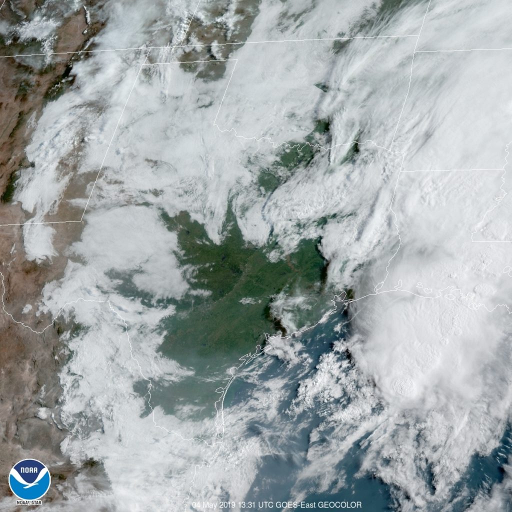
At 1051PM, CT, Corpus Christi was reporting a temperature if 75 degrees with mostly cloudy skies. There was smattering of clouds along the coast reflecting an onshore flow feeding thunderstorms along the dryline over west Texas. While there is indeed a strong system in the northern Plains, the threat of thunderstorms in the southern Plains was tied to the dry line, and is not going to move much further to the east. There isn’t a lot of upper level dynamics at work in the southeastern US, but guidance is pinging on a surface low developing near Del Rio on Tuesday morning. This will tap into the return flow suppling showers further north, and begin to follow the same course. This will mean heavier showers and storms over the Corpus Christi region on Tuesday. It will be forced to oblivion as a stronger feature develops along the Colorado-New Mexico border. Tomorrow – Mostly cloudy, High 85, Low 73 Tuesday — Showers and storms, especially early, High 83, Low 75
TWC: Tomorrow – Variable clouds with thunderstorms, especially in the afternoon. High 83, Low 73 Tuesday – Thunderstorms likely, especially in the morning…and becoming windy High 84, Low 74
AW: Tomorrow – A shower in the morning, then a few strong t-storms; storms can bring flooding and damaging winds High 84, Low 71 Tuesday – Mostly cloudy; a shower or thunderstorm around, breezy and humid High 84, Low 72
NWS: Tomorrow – Showers and thunderstorms likely, mainly after 1pm. Cloudy High 83, Low 75 Tuesday – A 40 percent chance of showers and thunderstorms. Mostly cloudy High 85, Low 75
WB: Tomorrow – Mostly cloudy. A slight chance of showers and thunderstorms in the morning, then a chance of showers and thunderstorms in the afternoon. High 82, Low 76 Tuesday – Mostly cloudy with a 40 percent chance of thunderstorms, High 82, Low 76
FIO: Tomorrow – Mostly cloudy with scattered storms, High 84, Low 74 Tuesday – Mostly cloudy with scattered storms, High 85, Low 75
FIO: Tomorrow – Light rain in the afternoon. High 82, Low 74 Tuesday – Rain starting overnight, continuing until morning. High 83, Low 76
Here is the satellite, with interior Texas looking clear, but a line of storms near the Big Bend.
We are about as close to mountains at the start and end of this trip as we can get, but yet we will only spend a quick moment in eastern Tennessee contending with elevation changes. We’ll maintain a pace of nearly 70mph as a result, and cover 553 miles per each of the first two days, but leave a little more than half a day to get through the high country on Monday. The Plains are getting active. Is any chasing in order?
Denver, Colorado
DAY ONE (Saturday) It’s become so active across the country that some systems are becoming unable to find a full wealth of energy and really get going. so it will be on Saturday as we drive the vast expanses of Kansas. There will be a front snaking through Nebraska and western Kansas, but it won’t be doing much, except producing a few gentle rolling clouds, and maybe…. maaaaybe a dry thunderstorm or light rain shower. The bulk of the moisture is going to be in the southeast, unable to reach the front attached to a low moving along the Canadian border. It will get even more serene as the day continues, and our day will end in Lawrence.
DAY TWO (Sunday) A cold front will be sagging towards eastern Kansas by Sunday morning, but this is the rare case where heating of the day will actually serve to stabilize the region, and we should leave Lawrence with showers diminishing to the west. Tentative high pressure will set up between this fading band of showers and the retreating area of rain and thudnerstorms in the southeast. As a result, we will bisect Missouri, clip Illinois and Kentucky and reach Clarksville, Tennessee without much of a threat of rain.
DAY THREE (Monday) I’m not sure you could ask for a better day to drive through Tennessee than next Monday. Temperatures won’t swelter, and the sun will be out. We’ll snake into Athens with only a few clouds in the sky, temperatures comfortable and a few hours to spare left in the afternoon.
Savannah is a nice southern town, good for vacations, and things played out perfectly for out of town guests last week. First, temperatures overnight dipped into the 50s both Thursday and Friday morning which was cooler than had been anticipated, and then there was no shower or thunderstorm activity on Friday, as all the storms associated with a passing cold front were drawn north or shunted south of the city. Forecast.io was the only outlet to correctly call for a dry day, but Accuweather had cool overnight lows and secured the victory on their own. Actuals: Thursday, High 86, Low 58 Friday – High 82, Low 59