It’s been a cool stretch of rain soaked weather for a lot of the interior part of the country, from the Great Lakes to the Plains. Ah, but how we forget how warm it got at the end of last week. Kokomo saw temperatures that nearly hit 90 on Friday. In a bit of good news, forecasts were fairly competent across the board, leading to a three way tie between Victoria-Weather, Weatherbug and Forecast.io. WeatherNation would have been in good shape, had they not fat fingered the low forecast for Friday. Actuals: Thursday – High 81, Low 61 Friday – High 88, Low 66
Before I got the map for this trip, I wondered if it would take us through the Twin Cities or the Upper Peninsula, and it turns out, it was neither. It’s going to be a one day trip that takes us 627 miles and right through Chicago. The route through rural Wisconsin, followed by the decidedly not rural Chicago will slow us down to a 61mph pace, but that’s ok because we are getting it all done in one day.
Duluth, Minnesota
I found what might be the least attractive angle of Duluth I could, just because the intent is to leave this fine city for Indiana. We will be between systems as we set forth tomorrow, which makes for a much easier drive. A warm front lifting north ahead of the next feature coming eastward will touch off some late showers or convention (probably convection, frankly) in northern Wisconsin. We will likely steer clear of the wet weather before it initiates, and will only deal with a hot, stuffy traffic jam late in the afternoon in Chicago, before we trundle on in to Kokomo.
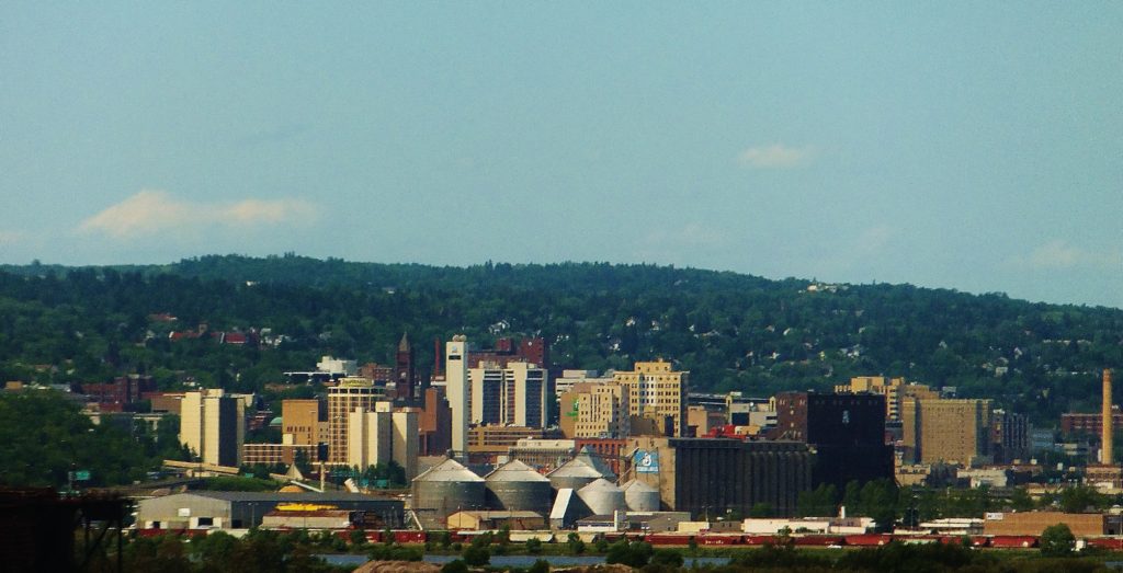
All right gang, we’re ready to head to another forecast destination. After a forecast in my current home state, how about one in my former residence?
At 856AM, ET, Kokomo was reporting overcast skies with a temperature of 59 degrees. A deeply occluded system in the Upper Midwest was recentered over Iowa, and the slowly being digested warm front was shifting north through Indiana. The warm sector and copious rain was found in Illinois, but scattered showers were prevalent in the Hoosier State as well. The bundle of low pressure at the end of the occluded boundary will shift from Iowa through Indiana as the day progresses, eventually giving way to a quiet night. The passage of the system today will allow Kokomo a much more pleasant and significantly drier day on Thursday. A broad upper level trough moving into the northwestern US will give rise to a vast, vibrant area of low pressure in the northern High Plains late Thursday into Friday. Some rain showers are possibly as warm air surges northward on Friday morning, but more significant will be the line of thunderstorms expected to light up across northern Indiana on Friday night. The heaviest weather will be north and west of town, but some late, noisy, windy storms are expected before midnight. Tomorrow – Mostly cloudy, High 81, Low 58 Friday – Transient clouds, with chances for a bit of rain early and especially late. Humid. High 86, Low 65
TWC: Tomorrow – Partly cloudy skies. High 85, Low 58 Friday – Windy with a few clouds from time to time. High 88, Low 69
AW: Tomorrow – Warmer with times of sun and clouds High 82, Low 57 Friday – Breezy, very warm and humid with partial sunshine High 88, Low 70
NWS: Tomorrow – Mostly sunny, High 82, Low 56 Friday – A slight chance of showers and thunderstorms before 8am, then a slight chance of showers and thunderstorms after 2pm. Mostly sunny, High 87, Low 67
WB: Tomorrow – Warmer, Mostly sunny. High 81, Low 59 Friday – Breezy, Partly cloudy. A 20 percent chance of showers and thunderstorms in the afternoon. High 87, Low 69
WN: Tomorrow – Mostly sunny, High 82, Low 59 Friday 0 Partly cloudy with isolated thunderstorms, High 87, Low 56
FIO: Tomorrow – Partly cloudy throughout the day. High 84, Low 59 Friday – Windy in the morning. High 88, Low 69
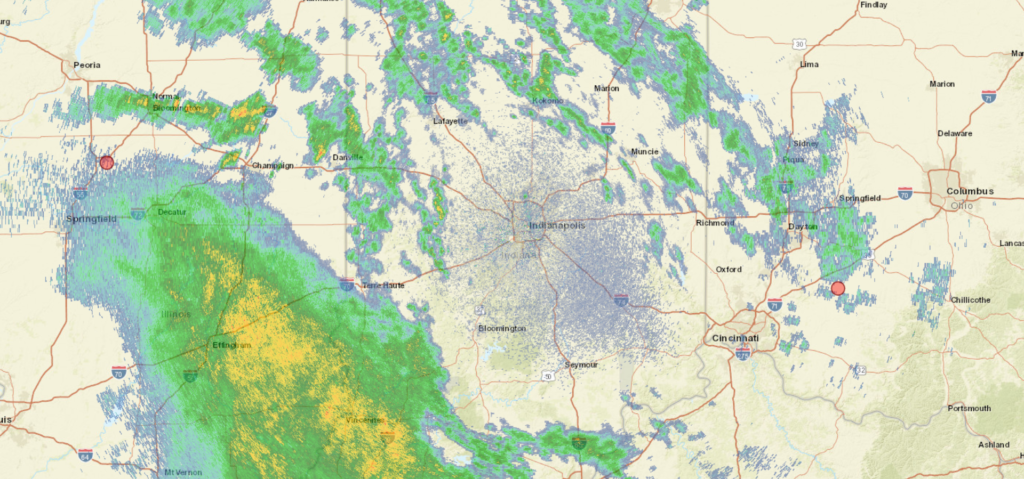
Oh my, it seems as though someone at Weathernation slipped on the keyboard when assigning the Friday morning low. It really is 56 on their site. Now I don’t feel so bad going on the low side for my forecast! Look at all this rain coming for southern Indiana. The Ohio is going to be running pretty quickly!
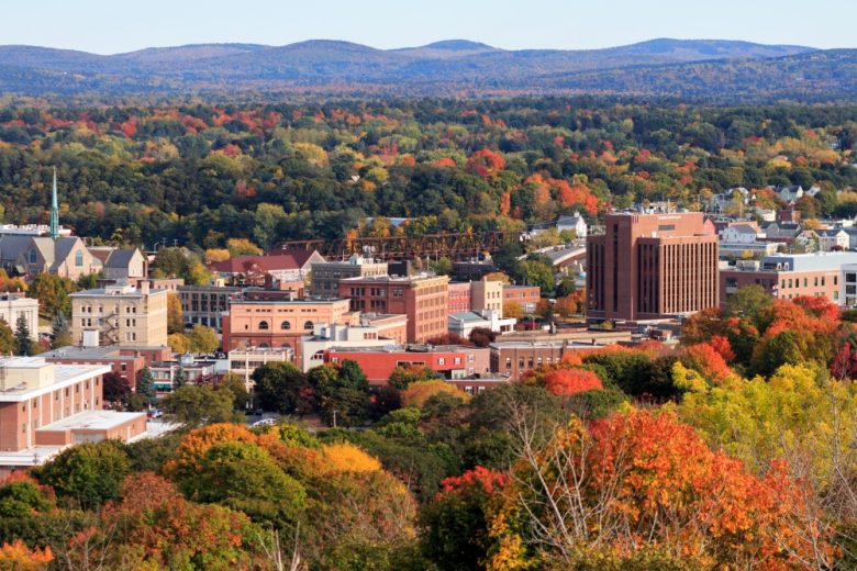
Let’s go for a drive. And while we’re at it, let’s go for a drive in the fall before the Lake Effect machine gets going. It takes two days to get from northern Indiana to Maine, though the second day might be an hour longer. The distance is 1,151 miles, which we will navigate at a speed of 65.5mph, pinning us somewhere in New York to conclude day one, with the left to spare on day two.
DAY ONE (Tuesday)
By Cameronloyd03 – Own work, CC BY-SA 4.0, https://commons.wikimedia.org/w/index.php?curid=61605902
Fall is coming to the northern part of the country, and it s coming in the form of a cold front sweeping into New England as we speak. Cool high pressure is pressing into the Great Lakes, and as we leave Kokomo, we will be headed right into this high pressure. We’ll make our way through northern Ohio and drive the southern shore of Lake Erie, all with barely a cloud, and make it to Le Roy, New York, south of Rochester as we take our sole pause on the journey.
DAY TWO (Wednesday) As that cold front gets off shore, it will phase with an upper level trough, and start development into an early season nor’easter. Terrific! Most of the drive in the Empire State will be dry, but east of Albany, the rain will start. It will be persistent and accompanied by stiff gales all the way through Massachusetts. Leaves are still on trees, so watch out for branches and debris on the roads, but as we pass through Haverhill and into New Hampshire, we will be in the clear, back into that cool, perhaps cloudy high pressure, into Bangor.