The end of July and beginning of August was a particularly stormy time for the north central US. It wasn’t all bad though, because it sure wiped out the heat wave that had buffeted the country. In Danville, temperatures on the 30th were near 90. After storms rolled through overnight, the 31st saw a high temperature of only 75. The dew point was still fairly warm, but that’s significantly more comfortable (were it not for the lingering smoke from the Canadian wildfires.) Never fear, summer isn’t over yet, and it is getting hot once again. The Weather Channel never cooled off, and won their third forecast in a row. Actuals: July 30th, .02″ of rain, High 89, Low 69 July 31st, .29″ of rain, High 75, Low 64
We are headed towards the middle of the country, on a drive that will spend quite a bit of time on I-80. It will take 4 days to cover this ground, because America is a big country. Expect a pace of about 69.4 mph, which is pretty great, actually. Hopefully, the weather will cooperate as well.
DAY ONE (Thursday)
Modesto, California
There is some signal that there will be an active monsoon, spreading as far west as the Cascades and northern Sierras. Not really the monsoon, I guess, at that point, but it will follow a similar diurnal pattern. I wouldn’t expect it to occur far enough or early enough in California to be a concern, and the drive through Nevada will be generally featureless, both with the weather and the man made structures. The day will end in Welcome, as we approach the Utah border.
DAY TWO (Friday) The monsoon will make more sense on Friday, following the Front Range in Colorado and Wyoming, which we will approach on our second day on the road. We’ll make it to the Akal rest area west of Laramie, and we may see a spot of rain at the end of the day. Nothing overwhelming, surely, and definitely not anything that will substantially slow us down.
DAY THREE (Saturday) The impulse coming away from the front range, the one that we approached at the end of our Saturday drive, will lurk through central Nebraska for much of our Saturday drive. There will be patchy clouds, some spots of rain, heavy at times, and an isolated thunderstorm. We will take our turn off of I-80 in Lincoln and make it to Palmyra for the night. By that point, those showers and storms should be ramping up, and we may be in for quite the stormy evening.
DAY FOUR (Sunday) I didn’t realize when I was looking ahead to this forecast that we were spending none of our time on Sunday on I-80, and in fact, very little of our time will be on an interstate. We will make it across northern Missouri on US 36, but we will leave the weather in Nebraska (and maybe a bit in Iowa). The trough bringing storms to Palmyra will stall and provide some steadier rain for the eastern part of the Cornhusker state. By the time we have reached St. Joseph and turned on to 36, we will have reached the end of the precipitation for our journey. We will cross Missouri in mostly sweltering sunshine before crossing the Mississippi in Hannibal and finally slicing through the heart of Illinois to reach our destination in Danville. It will feel summery to end the weekend.
Danville lies along the Indiana border, south of Chicago, and deep inside of corn sweat country. Are you ready to swelter?
At 355PM, CT, Danville was reporting a temperature of 91 degrees with clear skies. Importantly, dewpoints were in the low to mid 70s across the regions, making things even more uncomfortable. Lower level forcing is driving a bit of surface development, which is initiating in the High Plains. The moisture that crops up here will then track along the southern edge of a ridge that has emerged over the north central part of the US. There is, as a result, a marginal risk of severe weather for the area tomorrow. There is weak forcing but unstable air. Things may unfold quickly. If things proceed as current longer range models indicate, storms will arrive in Danville and linger into the overnight hours, before exiting town in the predawn of Thursday. If this is another derecho, as have been frequent of late, don’t be surprised if the onset is earlier than currently indicated. Fortunately, the ridge is going to continue to squash further south. It isn’t necessarily enjoying the benefit of cold air, but the air is dryer, and Thursday afternoon, at the very least, will be pleasant. Tomorrow – Rain in the afternoon, with strong thunderstorms possible overnight, High 92, Low 72 Thursday – Early morning thunderstorms, with gusty winds, then much more pleasant, High 79, Low 66
TWC: Tomorrow – A mix of clouds and sun early, then becoming cloudy later in the day. A stray thunderstorm is possible High 91, Low 70 Thursday – Scattered thunderstorms in the morning, then cloudy skies late. High 75, Low 66
AW: Tomorrow – Warm and humid with variable cloudiness; a couple of heavy thunderstorms in the afternoon; storms can bring flash flooding and damaging winds High 89, Low 70 Thursday – Periods of rain and a thunderstorm in the morning; mostly cloudy and humid; heavy downpours can reduce visibility and cause ponding on streets and highways High 74, Low 68
NWS: Tomorrow – 40 percent chance of showers and thunderstorms after 1pm. High 89, Low 72 Thursday – A 50 percent chance of showers and thunderstorms before 1pm. High 77, Low 65
WB: Tomorrow – Patchy fog in the morning. Sunny with a slight chance of showers and thunderstorms in the morning then partly sunny with a chance of showers and thunderstorms in the afternoon. High 93, Low 74 Thursday – Mostly cloudy. A chance of showers and thunderstorms in the morning. High 76, Low 66
WN: Tomorrow – Partly cloudy with a chance of storms, High 89, Low 72 Thursday – Mostly cloudy with a chance of storms, High 78, Low 65
CLI: Tomorrow – Thunderstorm, High 91, Low 71 Thursday – Thunderstorm, High 76, Low 63
Clearly, whatever happens in Danville this week is going to have a real impact. Expect better sleeping this later this week, central Illinois. Satellite with a few clouds by St. Louis before the sun goes down.
Labor Day weekend was very hot for the middle of the country, but it took a little bit of ramping up. It wasn’t very warm yet when we forecast for Danville. The temperatures were on the rise, though, finishing at 86 on the 2nd, better than the 55 we observed to start the forecast on the 31st. Victoria-Weather took the W for Danville. Actuals: September 1st, High 82, Low 54 September 2d, High 86, Low 54
Danville is south of Chicago and snuggled up next to Indiana. The whole region is consumed by corn fields.
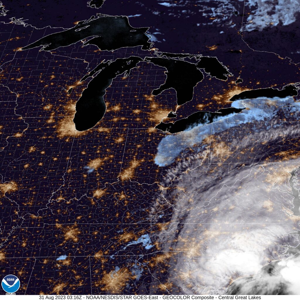
At 959PM, CT, Danville was reporting a temperature of 55 degrees with fair skies. Dew points were in the low 50s as well, and thanks to the looming harvest, the air around Danville was a bit moister, and will be prone to fog on clear nights such as today. High pressure is currently in place, while Idalia in the Carolinas had started to pull some cooler moisture from Canada towards the low, bringing some cooler air to Danville. Temperatures will remain a bit suppressed while a wave moves just north of the Canadian border. Even though the system is bringing severe weather to the northern High Plains tonight, it will leave northern Illinois dry. After this feature shifts on, temperatures in Danville will really start to climb, just in time for the holiday weekend. Tomorrow – Mostly sunny, High 79, Low 50 Friday – Sunny and warmer, High 85, Low 50
TWC: Tomorrow – Mainly sunny High 77, Low 49 Friday – Sunny skies High 83, Low 52
AW: Tomorrow – Plenty of sunshine; a nice end to August High 78, Low 49 Friday – Nice with plenty of sunshine High 85, Low 51
NWS: Tomorrow – Sunny High 78, Low 49 Friday – Sunny High 83, Low 51
WB: Tomorrow – Sunny High 76, Low 50 Friday – Sunny High 83, Low 53
WN: Tomorrow – Sunny High 78, Low 49 Friday – Sunny High 83, Low 52
CLI: Tomorrow – Clear, High 77, Low 50 Friday – Sunny, High 82, Low 52
The GFS was much warmer than all other models for Danville, and nearly every outlett abandoned that guidance. The warmth is coming, just a matter of when. Here is the satellite, with Idalia in the southeast corner.