10:19PM: The heat is on, with record breaking warmth across the west. The NWS has a discussion covering this heat wave that is valid through the weekend.
11:48PM. Spring!
from Victoria-Weather

10:19PM: The heat is on, with record breaking warmth across the west. The NWS has a discussion covering this heat wave that is valid through the weekend.
11:48PM. Spring!
10:33PM: Absolutely, we aren’t going to be worrying about snow in Appalachia like we saw in the Great Lakes over the last couple of days, or like we saw on the East Coast last month, but I’m here to tell you, wind knows no bound by temperature of latitude.
One thing that comes up every year, it seems, and one thing that I write about every single year, is the amount of variability that a single forecast can hold. If you live in the Great Lakes, it feels like there was a particularly significant tornado event, though the SPC had a Marginal Outlook that day. And it was a marginal event. There was one storm that had one track. Terribly, it tracked through three towns and caused damage and heart break and loss of life along the way.
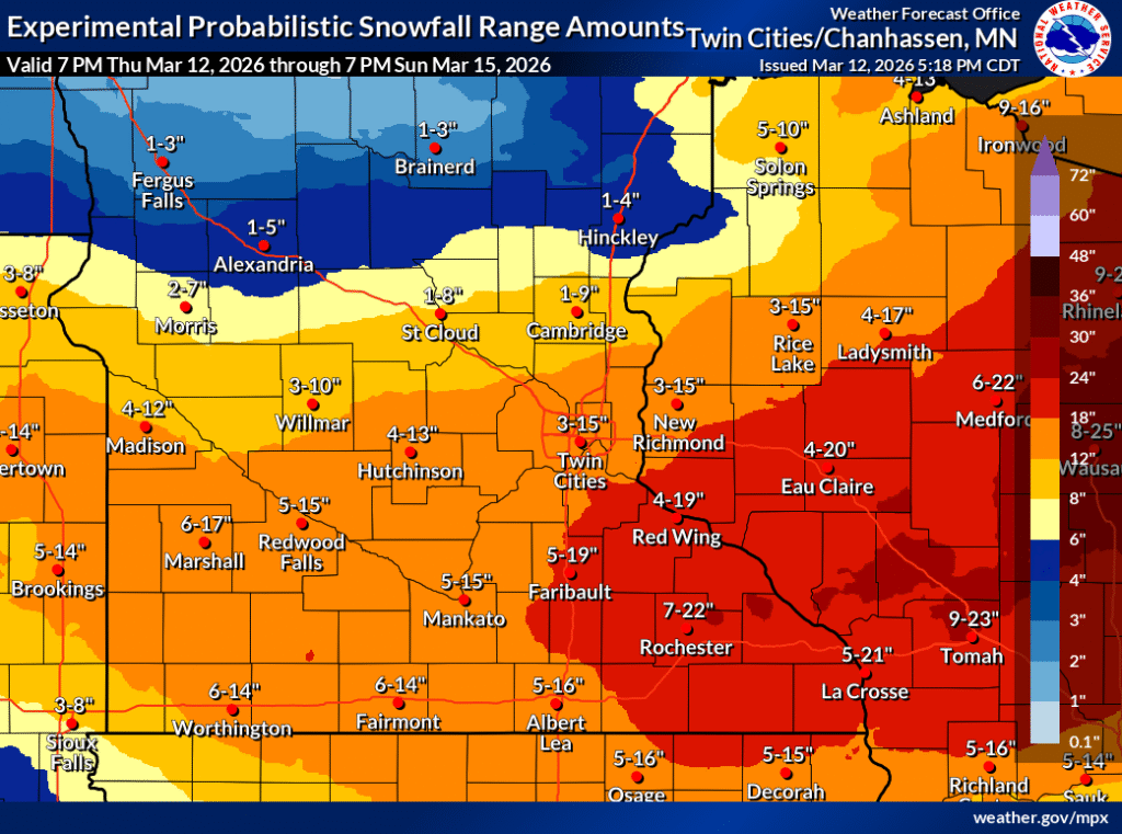
In Minneapolis, there was a significant snow storm over the weekend. There were forecasts that called for nearly two feet of snow as a possibility in the metro and throughout western Wisconsin. There were accumulations of that high degree, but they were about 30 miles southeast of Minneapolis. It was a slog, to be sure, but not the one that had been feared originally.
This time, though, I want to tie it back to a couple of other trending headlines. Artificial Intelligence and the current administration. Artificial Intelligence has been around for a while. The big change is a revolution in computational power. Meteorologists have used numerical models for decades, now, and they have been aided by computers since that time. They work by reducing the time it takes to navigate the numbers ingested into the models. Increasing compute abilities makes the models run faster, and without the same server load.
The increased ability to compute these models has allowed private enterprise, and increasingly, private citizens to develop their own models, based on smaller territories, or focused on specific metrics derived from the model guidance. There are any number of WRF models for specific locations out there now. It takes a lot less to crank one of these models out, for the same reason that AI is exploding nowadays: Faster computers.
But the problem with models is the same as it has always been. They are only as good as the data that is ingested to generate them. More or less ,this is the problem with AI and the large language models that are so popular. Real time data is collected hourly from airports and other sensor sites. Upper air data is collected in the weather balloons sent from WFO office, of which there aren’t really THAT many. And they are sent up fewer times a day. And now, actually, even fewer than before thanks to government cutbacks.
There is a larger point that could be made about AI and it’s future impact (that it’s only as good as the user and data ingested), but instead, I’ll make a point that I make annually. The forecast will always get you close to what will transpire perfectly, however there is always going to be some inaccuracy, related to the resolution of the models. It then is on us, the consumer to monitor weather that is ongoing, and to know your local geography.
Man, if I write this every year, maybe I should just ChatGPT it next year?
10:31PM: The snow is done in the Twin Cities, though the wind has arrived. While totals were not as dramatic in the Cities as the most dire forecasts, residents of Red Wing, Lake City and other towns in southeast Minnesota can attest that the storm still packed plenty of punch, with 20″ reported around those communities. It’s higher in central Wisconsin. But back to the Twin Cities. The tie ups go to show that getting much over 8″ is all the same. The 13″ I got here were plenty
There have been plenty of, and will continue to be plenty of, storms for the spring. This weekend will be highlighted by snow and severe weather. Behind that? Historic warmth.
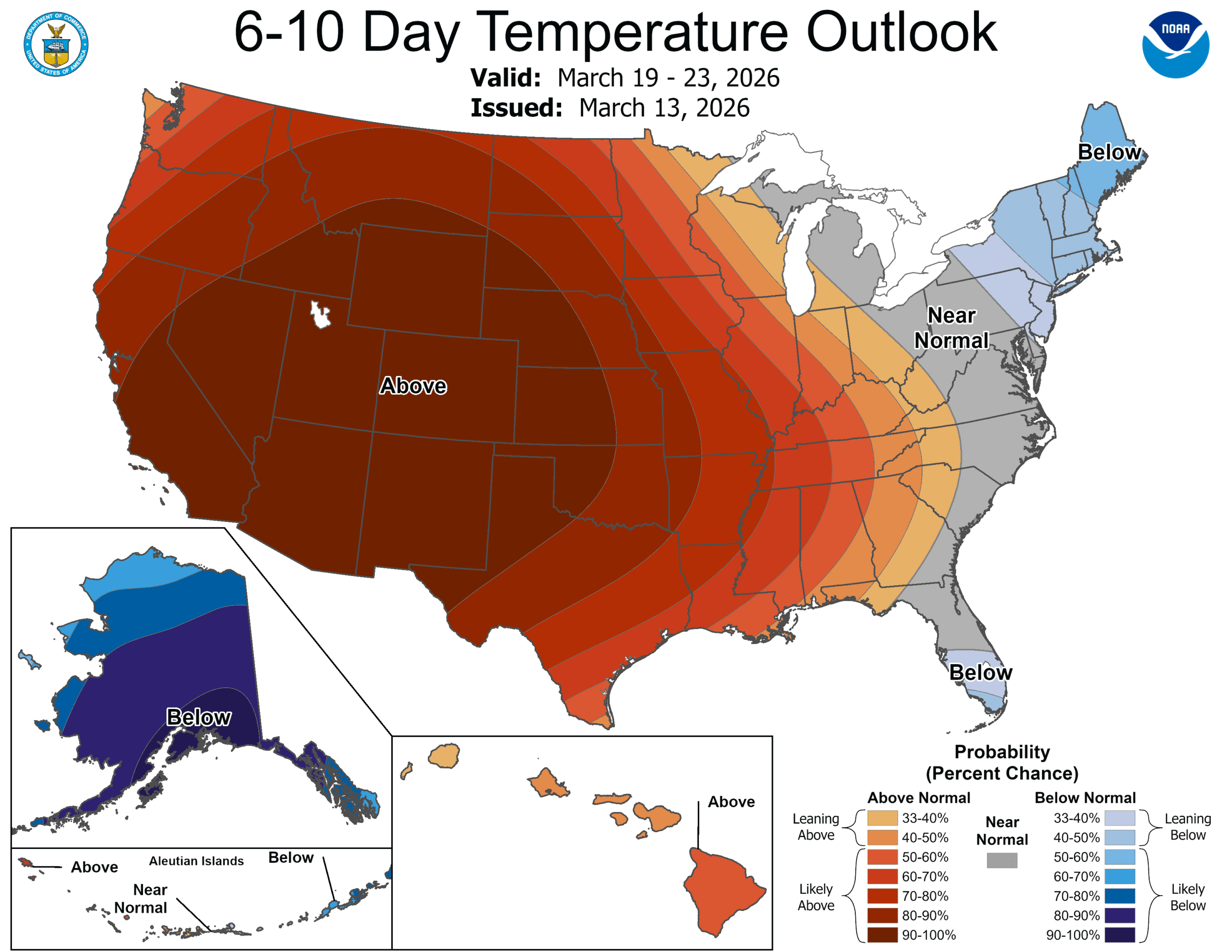
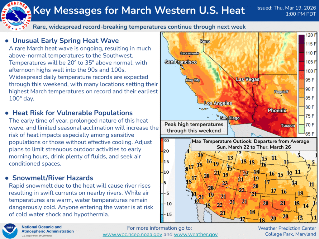
A double round of hot weather is coming for the western US, and will end ski season and all the good vibes of a healthy winter of moisture. We aren’t just talking a little warm, either. By the middle of next week, places like St. George, Utah could see triple digits. On St. Patrick’s Day!
A strong, standing ridge will arc over the western Continental US. Despite a good system in the Gulf of Alaska, the hot high pressure is going to be stuck in. The jet will eventually weaken, but not necessarily move. The heat may wear off as March wears on, but it will not ever fully go away, not for a while, anyhow.
The real hazard will ultimately come from the strength of the surface ridge, and whether or not Santa Ana winds compound things in Southern California.
And yes, between the last two posts here, it’s been a real roller coaster.
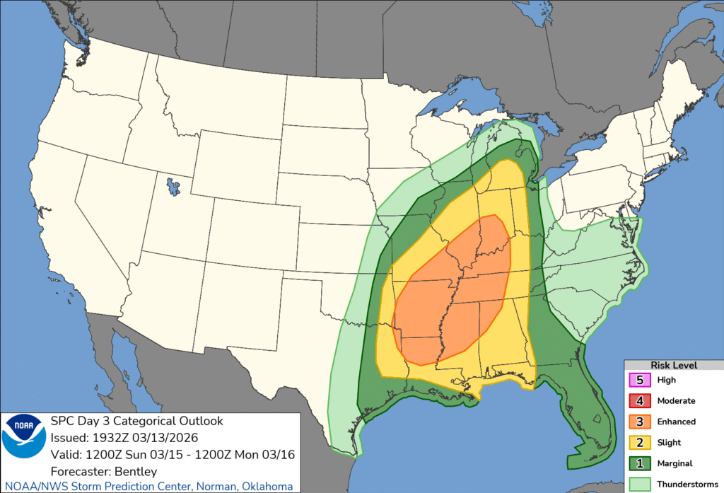
10:15PM: Here in Minnesota, we’re worried primarily about the overwhelming amount of snow and ice that is coming our way. As I noted, however, we’ve got a jump on the severe weather season as well for many parts of the country. The more traditional March storm zone will get it on Sunday. It will be a good day to remain vigilant in the Mississippi Valley, east to the Tennessee Valley.
There was another deadly tornado event in the Great Lakes area on Tuesday. This time, a pair of tornadoes struck south of Chicago, near Kankakee and across the border in Lake Village, Indiana, where two were killed. Local authorities said that, where it not for advanced warnings before the storms struck. The weather impact will not be as further to the northwest over the next 72 hours, but also, we will be absent the forecast certainty.
I’m sorry? What? WHAT?!
It has already started this evening in Minnesota, and this weekend will be…. something?
The National Weather Service has a feature in which you can see the percentage chance of getting over a certain accumulation level. In the Twin Cities, the chance of getting over 4″ is 71%, over 6″ it is 56%, but then over 8″ it is 46% and over a foot is 35%. If it snows over a few inches, Twin Citians may as well plan on a foot.
That’s no way to go through life!
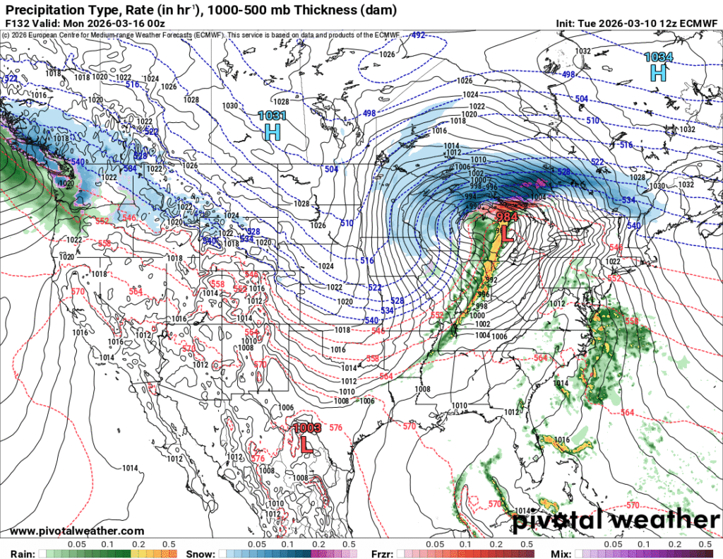
There is a system moving into the Great Lakes tonight, and a stalled boundary that will linger in the region tomorrow, and a warm front that will fill in on Saturday. The real show will come on Sunday.
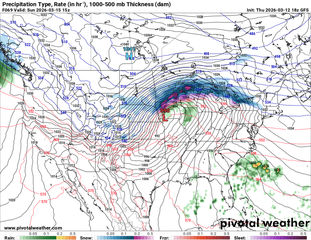
One way or another, that’s a lot of precipitation inbound. The uncertainty lies with the temperature profile, for one thing, and exactly where that heaviest band of precipitation will set itself up. I wouldn’t be surprised if there is a band maybe 20 miles wide that clears a foot and a half of snow, with the accumulation falling off significantly on either side of that band.
That’s probably the hedge that the NWS is also leaning on, and it will be tough to determine where that heavy band is going to set up, until it sets up.
Between the uncharacteristic rains earlier in the year, but before the heat settled in to this part of the world, we took a trip to San Diego. The forecast was issued at just the right time, to capture postcard perfect weather. At the end of February and beginning of March, temperatures were starting to creep up there, which meant outlets that were on the warm side generally fared better. In this instance, it was the Weather Service who secured the top spot, but with conditions like these, nobody is even worried about those on the bottom — The weather would have been great if their forecast was perfect, too.
Actuals: February 28th, High 81, Low 62
March 1st, High 78, Low 56
Grade: B
10:27PM: Unfortunately, the pattern we are in is sticking around. The threat for severe storms will return from the southern Great Lakes southward. I expect a reduced tornado threat, and, yikes…. potential blizzard conditions in Michigan and Wisconsin
It’s certainly not unheard of to have severe weather in March. In fact, it’s pretty standard for the first major spring storms to start appearing as early as mid-February nowadays. If there has been anything strange, it is that the storms haven’t been as problematic for Mississippi and Alabama, frequent targets for early season outbreaks.
This past week has featured deadly tornadoes in both Oklahoma and Michigan. Both locales are certainly accustomed to severe weather, but these outbreaks and the deaths because of them speak to the fickle nature of severe weather, rather than the particular strength of the storms in question.
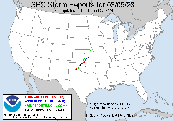
In Oklahoma, there were two days of tornado related fatalities. The first came on the 5th, when a mother and daughter were killed in their vehicle in the northwestern part of the state. The guilty cell was an isolated supercell tracked from the Texas Panhandle
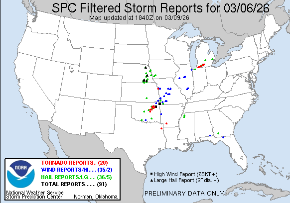
The storms were more widespread on the 6th, with storms, including a fatal storm in the Tulsa area. Certainly, it was unfortunate that such a storm would batter a large population center like this. Even more unfortunate was what looks like a single long track cell that went directly from Edwardsburg, Michigan to Three Rivers, Michigan to Union City, Michigan, doing this: along the way:
This storm claimed the lives of six in southwest Michigan. Aside from this cell, there were no other severe reports in Michigan. This goes to the seasonal reminder that not every tornado is in an outbreak, but all tornadoes can be dangerous. The highest threat level for those days was an “enhanced” risk in the southern Plains, while much of Michigan was labeled as marginal. It’s a reminder for added vigilance when storms are in the forecast, in case the 1 in 10 chance hits, and there are tornadoes, and your home or route is within the quarter mile width of the looming storm.
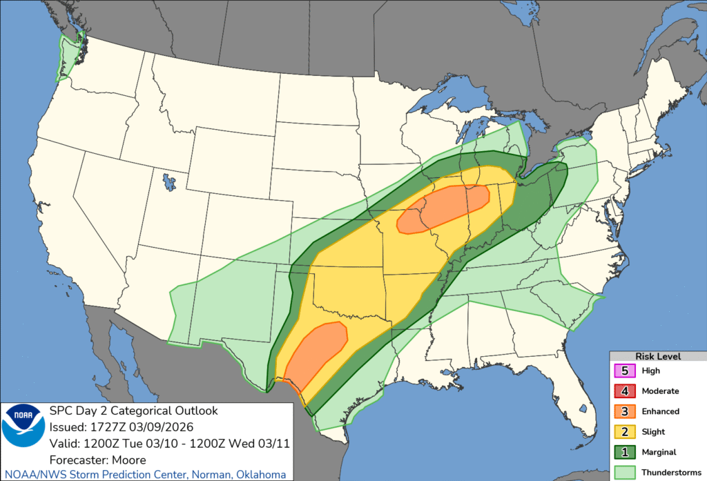
We do have more storms ahead. It is that time of year, when cold Canadian air is hanging on across the Plains, but the Gulf has started to pump heat and humidity back to the north. Our conflict zone tomorrow, will be from the Great Lakes to the Big Bend of Texas. There are enhanced risk zones at either end of the forecast thunderstorms. Be careful.