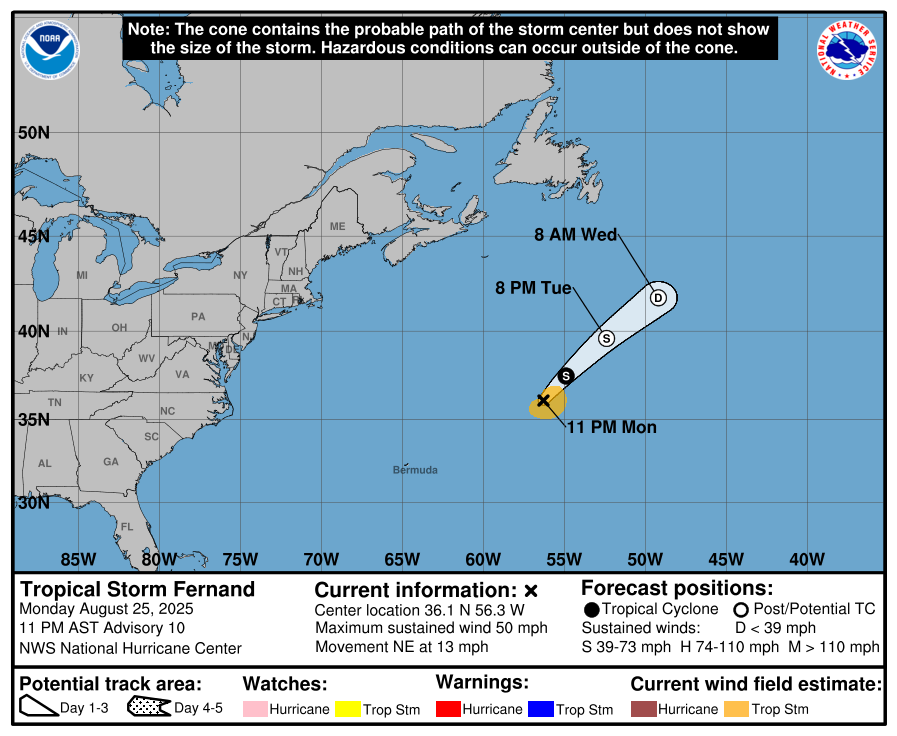
1027AM The shower activity that cropped up last night is now north of Dallas, in the Red River Valley. There is a little bit of thunder with it, but mostly, it is just here to nourish the crops. Overnight, some of those storms produced strong winds which unfortunately proved lethal and caused damage
1125pm – The threat for stronger storms has again increased late in the day. A marginal risk was plopped in Texas as a narrow band of thunder cropped up in the middle of the state, drifting north.
There are snow showers and winter weather alerts from Oklahoma to New Mexico, stemming from this very system.
Rare is the occasion that it is after 8pm, CT, there is an enhanced risk for severe weather and it hasn’t popped yet. There is a mesoscale discussion in anticipation of a looming watch in central Oklahoma and North Central Texas, and the HRRR still has storms popping around Weatherford…. soon.
This is the opening salvo of a multi day outbreak, which is also the first significant storm of meteorological spring. It’s not a surprise. Tomorrow has been flagged as a potential severe weather day since last week. If there is a surprise, it is that the SPC hasn’t upped the outlook to moderate yet. The storm still looks strong, but not any stronger than it looked days ago.
Storms tonight will feature strong winds and a threat for tornados (hence the pending tornado watch), all a part of a broken line of storms, with a stronger threat for larger tornadoes in the Lower Mississippi Valley tomorrow, including isolated supercells. This will be the most significant of the severe weather in terms of intensity and geographic coverage, but more rough weather is likely in the Coastal Plains from the Mid Atlantic to Georgia on Wednesday.
Tonight, Oklahoma City and Dallas may be early morning recipients of the strong weather, while tomorrow, we will look at Shreveport, Jackson and Mobile and surrounding locales. Again, the headliner is tornadoes, but straight line squalls will be a factor as well.
This is all brought on by a deep, well defined and fast moving trough, a hallmark of Spring. Another hallmark of these big spring storms is that there will be snow on the back end of the feature. Ample moisture and energy will lead 4-8″ in many locations from Iowa to Michigan, including a dumping on the Upper Peninsula.
This will be a dangerous weather pattern for the middle of the country, with the first severe outbreak testing readiness, as well as probably bringing out storm chasers, making things a bit dicey on the roads. This will be the first rodeo with the slimmed down Weather Service as well, which makes weather minds tense more than normal. As I noted, this storm has been anticipated for days. The first forecasts for it may have come from meteorologists no longer employed. We won’t get this kind of preparation time often.
Oh, I’ve been working on this post long enough, look what happened:
It is a sad day across the meteorology community. I know there are political undertones to everything, but particularly with the story today that hundreds of National Weather Service employees were laid off today and rumors are that there will be more to follow. I don’t believe it is controversial to say my heart aches for the mostly young men and women who had their dream jobs, and are now unemployed.
The American government is the single largest employer of meteorologists, and all of your favorite weather people have a personal connection with the Service one way or another. The compassion we feel is personal.
A lot has been made of how impersonal and cruel the cuts have been, which naturally makes it hurt more, knowing that friends and respected cohorts were so callously discarded. This has been a tough time for all federal employees and those that love them and appreciate them. The loss of meteorologists at the NWS cuts deeper for all of us, though.
We’ll notice next week as a major severe weather outbreak hits the southeast. We will again notice for subsequent storms this summer. We’ll notice during hurricane season. Private weather companies in America are built on the back of NWS data and systems. All of us will suffer under an understaffed Weather Service.
Other nations don’t have a similar bureau, but other nations don’t have the same kind of virulent, dangerous weather in all forms. In America, the federal Weather Service is a form of public safety that is irreplaceable. Forecast models come from the NWS, unless they come from abroad. Constant worldwide coordination seems like a challenge moving forward, staffing or not.
In a world where a high premium is placed on prediction, we are in uncertain times. Weather forecasting was changed forever today, and not for the better.
In the wake of the same system that brought flurries that lingered for Sandusky, cold air spilled into Ohio Valley. Temperatures in Columbus, Indiana, for example, struggled to get out of the 20s on Friday, which meant all of our forecasts came in too warm. Things sorted themselves out a bit better on Saturday though, so the real tough spot was the first day. The Weather Channel had the best time of it on Friday, and that led to their victory for the day Actuals: Friday – High 28, Low 15 Saturday – High 36, Low 14
What are you doing this week? How about a 5 day trip to the West Coast? The drive covers 2,760 miles, which will lend itself to a pace of 67mph, and about 539 miles a day. I-40 is calling your name!
DAY ONE (Monday)
Harrisburg, Pennsylvania
The first day of our journey offers good omens. Sunny skies and above average temperatures await Monday in the Ohio Valley. There will be a bit of a northwest flow off the Lakes but it won’t be cold enough for a good Lake effect fetch. Just enjoy the scenery, and end the day in Indianapolis. Wow, even starting the trip with a stop in a real city with hotels and stuff! This trip is going to be great!
DAY TWO (Tuesday)e As we enjoy the Circle City, a weak boundary, associated with a system moving through Canada, will slide through town, bringing a little sprinkle as we sleep. High pressure and more warm air will be in hot pursuit. It sounds exciting, but in effect, this just means we have more sunshine as we drive to Loma Linda, Missouri, just before the Oklahoma line.
DAY THREE (Wednesday) Flow in the Southern Plains will be a bit more turbulent on Wednesday, but only aloft. More clouds can be anticipated, but we will steer clear of any showers. That stuff will happen over central Oklahoma, long after we are through. The day in Glenrio, Texas, which is on the line with New Mexico.
DAY FOUR (Thursday) We are more than halfway through the week, and more than halfway through the drive. Our second to last day will again be marked by blue skies and comfortable temperatures. We get another good sized town in Flagstaff for our destination (as opposed to a border town)
DAY FIVE (Friday) Models are picking up on a rogue feature in the Pacific that, if realized, might bring some low clouds and drizzle to Point Concepcion. The drive from Flagstaff to the Coastal Range before that will be terrific, like the rest of the drive. Rain won’t last long or be likely, frankly, but prepare for fog and low clouds if that low is hanging offshore.
One of the longest named towns in our repertoire gets to host this late February forecast. The name may be the longest part of it.
At 1256PM, PT, San Luis Obispo was reporting clear skies and a brisk northwest wind. Despite the onshore flow, temperatures remained at 63, with a little more room to warm further. Low pressure in the Rockies is continuing to be tied to a feature in the Pacific Northwest, which is allowing for broadly onshore flow as far south as SLO. A thermal ridge will emerge late in the forecast period, which will contribute to a bit of a warm up, but flow will continue to to be onshore, moderating temperatures through the early part of the work week. Tomorrow – Mostly sunny, High 73, Low 47 Tuesday – A little morning fog, then sunny, High 74, Low 50
TWC: Tomorrow – Partly cloudy skies in the morning will give way to cloudy skies during the afternoon. High 72, Low 49 Tuesday – A few passing clouds, otherwise generally sunny. High 76, Low 51
AW: Tomorrow – Pleasant with plenty of sun; breezy in the afternoon High 70, Low 47 Tuesday – Warm with plenty of sun High 77, Low 52
NWS: Tomorrow – Mostly sunny, High 73, Low 52 Tuesday – Mostly sunny, High 73, Low 52
WB: Tomorrow – Partly cloudy, except for patchy low clouds and fog in the morning. Fog locally dense with visibility of 1/4 mile or less, High 65, Low 52 Tuesday – Partly cloudy in the morning, then sunny, High 74, Low 53
WN: Tomorrow – Partly cloudy, High 72, Low 53 Tuesday – Mostly sunny, High 72, Low 53
CLI – Tomorrow – Mostly cloudy, High 73, Low 47 Tuesday – Sunny, High 75, Low 50
Weatherbug is very sure of fog tonight, and has a very different forecast. But alas, no marine layer on satellite.
An under reported facet of the weather and forecasting in general is the wind direction. It stands a bit more at the forefront when lake effect snow is at play, as it was in Sandusky. The snow that was in the forecast lingered until the early afternoon on Friday, despite thoughts it would conclude on Thursday. Nobody had the snow right, so it came down to temperatures, and Victoria-Weather took the victory. Actuals: Thursday – Snow reported, not measured, High 25, Low 14 Friday – Snow reported, not measured, High 30, Low 21
You don’t need me to tell you that it has been an awfully chilly week. Is this spurred by a rough Valentine’s Day weekend? Probably not, but I can say that as we get away from that holiday, temperatures are rebounding in a fairly significant way.
After successive rounds of low pressure rotated through the US east of the Rockies, high pressure is building in, and it is going to try to stick for a little while. The upper level pattern isn’t terribly conducive to warm weather, but the time of year and amount of sunlight we are seeing, as well as a west wind off the Rockies, with a little bit of southerly flow through the Mississippi Valley is going to do a lot of the heavy lifting. It’s already started.
The above image from the WPC shows how much warmer it is already for parts of the Plains and lower great Lakes as compared to yesterday. And it will continue to get warmer further east today and into the weekend.
With high pressure in place, the jet is going to split over the weekend, with a ridge developing in a northerly jet, and a trough continuing to remain in place over the south central US. This will allow the warm up to remain in place, even as rain starts to move in to some of the Plains and western Gulf states. Then, it’s March.
We aren’t expecting any significantly abnormal temperatures in either direction to begin the month, but a normal day in March feels a heck of a lot better than a below normal day in February.
Spring is on its way, and we can start to prepare for some warmer weather. To ensure we get good weather for our forecast, we have two scheduled forecasts in the coming days in southern California.
San Luis Obispo, California Road trip from Harrisburg, Pennsylvania to San Luis Obispo
Poughkeepsie, New York Road Trip from Hinesville, Georgia to Poughkeepsie