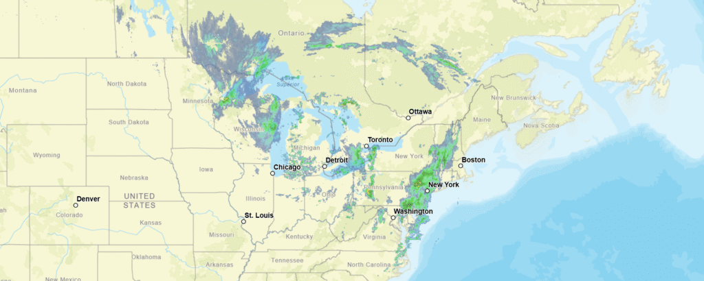
9:55PM: At long last, we are back in action! The trend has been towards cool weather across the country. It’s in the 40s for highs along the northern tier, and if it isn’t down there yet, it will be soon. A particularly effective cold front is coming for New England. Even without prodigious rain, it will bring temperatures down to something more autumnal. Sorry!
11:06PM: Just think, in a few weeks, this would all be snow. Well, actually not. All these light radar returns are actually upwind from the Great Lakes, which, as any local might be able to tell you, is not how Lake Effect Snow works.
1033PM: Oh, hey, it does look like indeed the SPC will continue to operate during the shut down. There is severe weather possible for the middle of the country, as far northeast as Paducah, Kentucky.
You may not remember this, because of the way the month ended, but it was a pretty cool month, running afoul of global trends for, I don’t know, a century, now? Standing in those headwinds, our forecasters needed to be particularly sure of what they were putting out there. Accuweather and Clime won co-shares of September’s title.
A lot of the conversation along the Gulf Coast this spring has involved varying degrees of the sentiment “Wow, it sure has been quiet!” And so it was when we forecast in Gulfport to round out September. The forecasts across the board lined up with the temperatures, which hit close to 90 in the afternoons. The Weather Channel was the top performer, but everyone should be happy with their score. Actuals: September 29th, High 89, Low 70 September 30th, High 90, Low 70
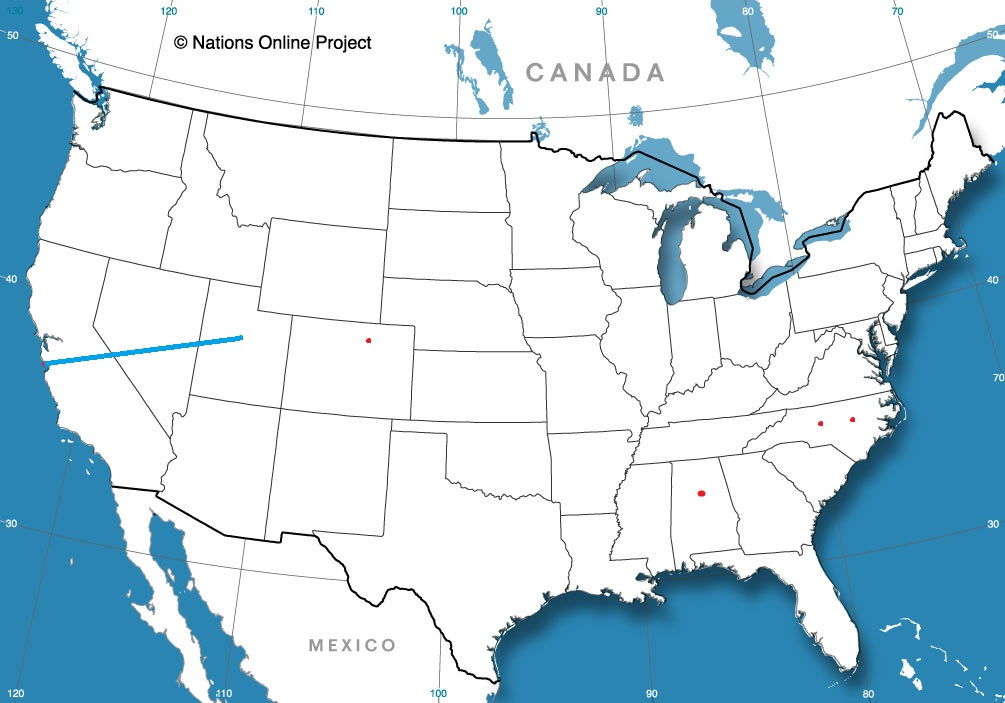
Confirmed: It is a long way from Portland to Dover. 2892 miles, in fact, and that distance will take us 5 days to cover, and that last day will be an 11 hour grind. The pace will be 67.2 mph, which translates to 538 miles a day. This is a long one, folks.
DAY ONE (Saturday)
Portland, Oregon
Low pressure will have moved inland from the Pacific Northwest as we depart tomorrow morning. Moisture will be able to clear the Cascades, but will begin to squeeze out moisture again as this instability reaches the Rockies. Rain will be tapering, but still possible in Portland to the Dalles, and we will be dry in the Columbia River Gorge. We will pop out again and head southeast towards Boise, where we will encounter a few more showers between Pendleton and Baker City. The higher terrain of Idaho is both well to the north of our route and well to the east. We will reach Wendell, between Mountain Home and Twin Falls, without fear of rain.
DAY TWO (Sunday) Precipitation in the mountains always looks messy, but there is expected to be organization in the lee of the Rockies, which will clear the skies along our route. No worries crossing the Wasatch, except for running out of gas. Not many places to stop, and we will end the night in Table Rock, Wyoming, which might not be a real place.
DAY THREE (Monday) This is going to be a weird point to refer to, but back in the Gulf of California, an old tropical feature will be making landfall, kicking some moisture from the south up into the Rockies. Some of this moisture is expected to bleed into the Plains, where it will intercept the tail of a cold front extending from Hudson Bay, and it may bring a light shower to south central Nebraska. That is a worst case scenario, though, and I don’t believe it likely. I think instead we will get some windswept prairie and a chilly time parking in Gibbon, for our stop on Monday night.
DAY FOUR (Tuesday) This wasn’t on my bingo board, but yes, on this trip we will be dealing with some tropical moisture in Nebraska on Tuesday. Rain should be starting overnight in Gibbon, which is near Kearney, if you were wondering, and may be steady at times, all the way to Omaha, which will be the largest city we will have seen in days. The rain will lighten, and we will dry out around Bondurant, shortly after passing Des Moines. Cedar Rapids and the Quad Cities will be dry, and we will make it about a third of the way through Illinois, stopping in Spring Valley for the night.
DAY FIVE (Wednesday) Because of the way this works we will touch parts of 7 states in 11 long hours. Fortunately, we should have unobstructed views of all those welcome signs, because high pressure will be building in the Great Lakes, pushing towards the mid-Atlantic. Temperatures will be comfortable for the season, and we will be exhausted upon arriving in Dover.
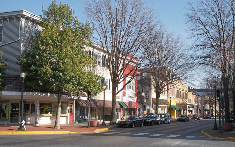
There isn’t a lot too Delaware, but given the location along the coast, it can sure serve up some interesting times.
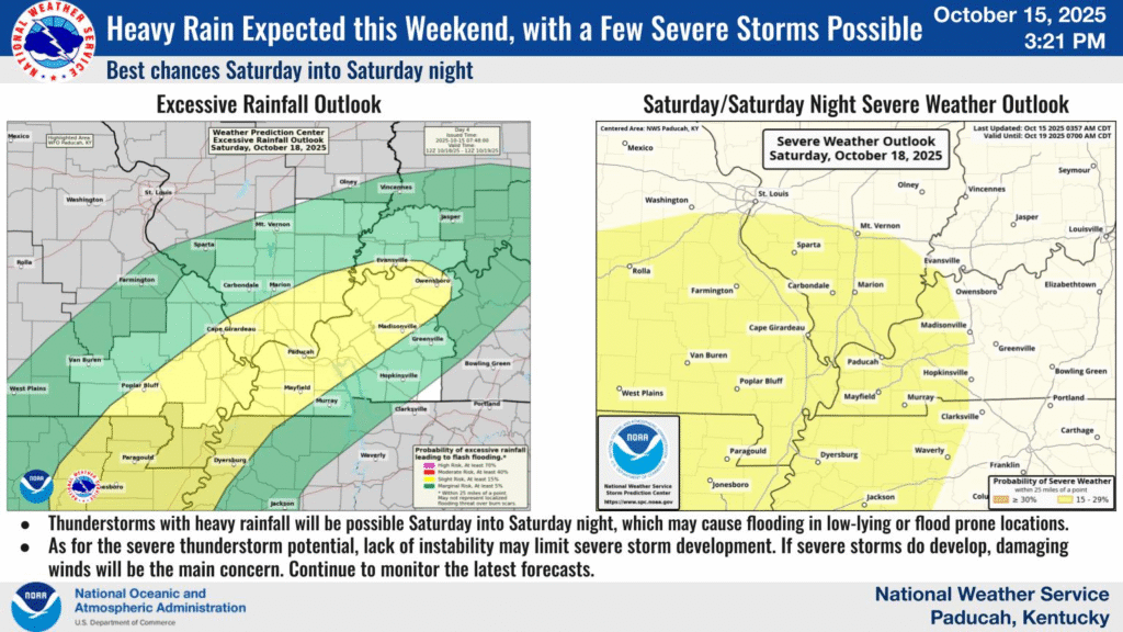
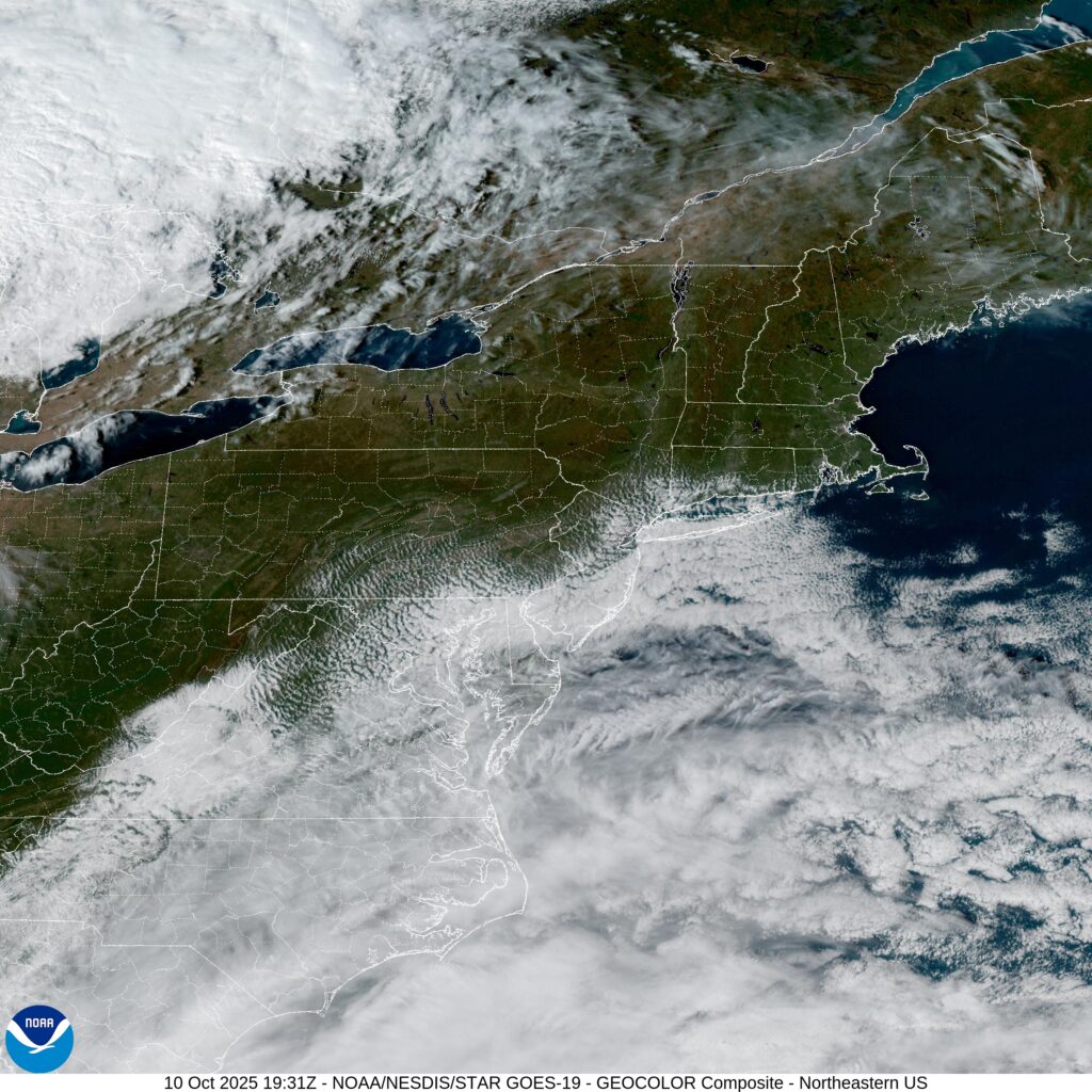
At 315PM, ET, Dover was reporting a temperature of 60 degrees with overcast skies. High pressure remains in control this afternoon in the Delmarva, however a deep cutting trough swinging out of the Great lakes towards an already unsettled region in the Bight of Georgia is going to bring about some significant changes for the weekend. The developing low, which may ultimately get a name from the NHC, but even if it doesn’t, it should be a very early season Nor’Easter for the coast. The initial spots of rain will arrive in Dover tomorrow morning, with the threat steadily increasing through the day. The strongest band of heavy rain projects to arrive on Sunday morning. This will likely be accompanied by some blustery winds and make for a wholly uncomfortable morning. The heavy rain will begin to taper in the early afternoon, but more light rain will continue through the remainder of the day. Tomorrow – Scattered showers, High 72, Low 58 Sunday – Rain with wind, tapering a bit in the evening, High 67, Low 60
TWC: Tomorrow – Overcast. Slight chance of a rain shower. High 71, Low 55 Sunday – Rain and wind. High 66, Low 64
AW: Tomorrow – Breezy with occasional rain and drizzle high 70, Low 57 Sunday – Rain and wind from tropical rainstorm; flooding in poor drainage areas; stronger wind and worse flooding at the beaches High 65, Low 60
NWS: Tomorrow – A chance of rain, mainly after 9am. Mostly cloudy, High 70, Low 55 Sunday – Rain, High 66, Low 60
WB: Tomorrow – Mostly cloudy with a 50 percent chance of rain. High 69, Low 56 Sunday – Rain windy .High 67, Low 61
WN: Tomorrow – Mostly cloudy with showers, High 70, Low 54 Sunday – Mostly cloudy with showers, High 67, low 61
CLI: Tomorrow – Rain showers High 69, low 58 Sunday – Light rain showers High 67, Low 60
Yuck. That’s going to be particularly nasty on Sunday. Don’t be surprised if there is a rumble or two with the heavy rain on Sunday. Looks good right now in the interior east!
When forecasting temperatures in the upper 80s, you wouldn’t be surprised, I imagine, to see those show up in Iowa. You would, however, be surprised to have them show up on the cusp of October, as they did in Davenport on the 28th and 29th of the month. it wasn’t a true surprise, of course, as this was well handled by the meteorologists. In fact, the biggest area of error was in the low temperature forecasts. The skies were too clear, and temperatures fell off more than anyone had in the forecast. Accuweather had the top spot in the Quad Cities, Actuals: September 28th, High 88, Low 56 September 29th, High 89, Low 52
This drive will take 5 days, headed cross country over 2,567miles at a pace of about 67.5mph, and a target of 540 miles a day. If you are like me, perhaps you are wondering “how long would it take to travel from these two ports by sea?” According to my research: Over a month. Let’s take the car!
DAY ONE (Thursday)
Gulfport, Mississippi
Pressure is high across most of the country, which long time readers know, of course, means weather is pretty ok! The first drive of this trip will start with some low clouds, maybe some drizzle in Gulfport, but just a short jaunt inland will bring much cooler temperatures and clearer skies. we’ll make it to Forney on the east side of Dallas after what should be a pretty nice day in the car.
DAY TWO (Friday) We will continue on our northwesterly voyage through what will probably be our driest and dustiest day. The route will carry us through west Texas and the Panhandles, before coming to an end in Campo, in far southeaster Colorado.
DAY THREE (Saturday) Westerly flow throughout the Rockies is going to start inducing some surface low pressure on the lee. Jet structure is going to amplify the development of low pressure, and moisture in the southwest will draw into the Rockies. There is definitely a shot at precipitation on Saturday, and I would say it will increase around Fort Collins, and be the most likely at the end of the day, as we unload in Wamsutter, Wyoming.
DAY FOUR (Sunday) Low pressure will work to consolidate overnight in Canada, and our route will dry out considerably. The precipitation on the west side of Wyoming may briefly be wet snow, so if you want to see that, get going early. Northern Utah and southern Idaho are going to be idyllic. We’ll stop in Meridien on the western side of Boise to conclude our drive.
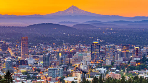
DAY FIVE (Monday) Low pressure will be scooting down the Pacific Coast into the Pacific Northwest as we wrap up our last day of travel. The low will bring the rain and low clouds that the Pacific Northwest is famous for, but it will be confined primarily to the area on the west side of the Cascades. The first remote chance of rain will be around Willow Lake, but the first real chances will be in The Dalles. Expect it to be a bit gloomy in Portland on our arrival.
Ooh boy, need to be careful with my keywords on this one. You haven’t heard about Portland in the news lately, have you?
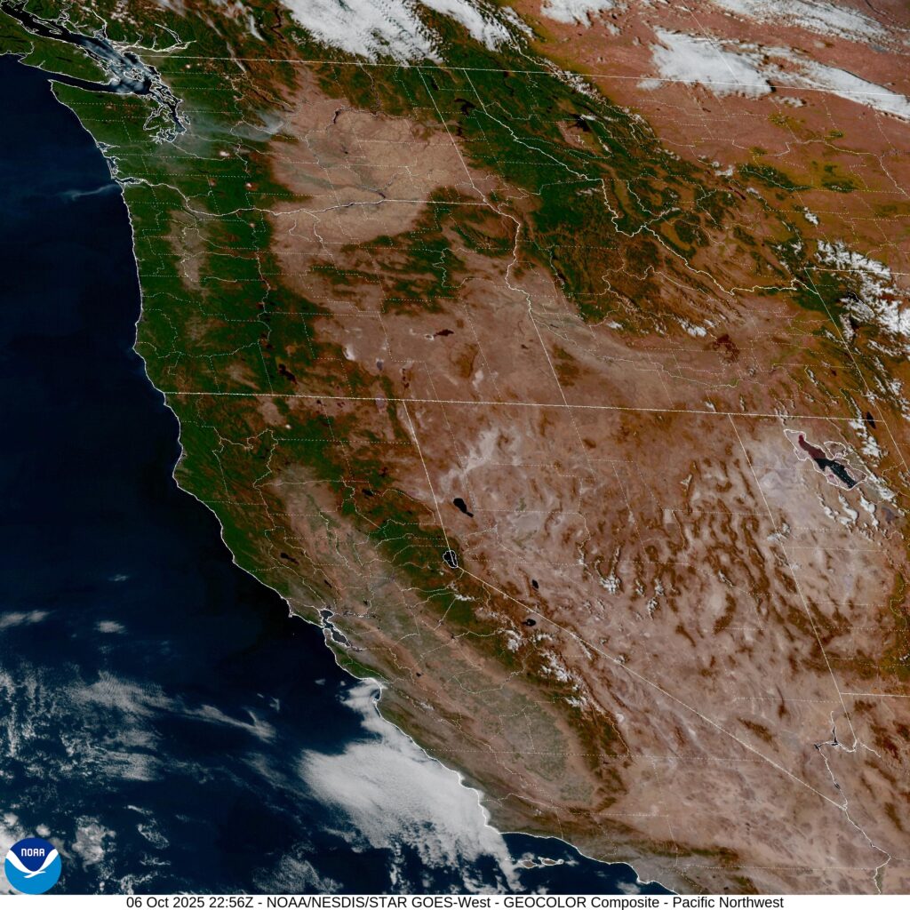
At 353PM, PT, Portland was reporting a temperature of 78 degrees with clear skies. The Pacific Northwest was enjoying a nice, warm and clear stretch to begin the week, which was allowing temperatures to be warm, though not unbearable. A jet trough is sliding southeasterly along the British Columbian coast, which may bring about a few more upper level clouds as well as a refreshing ocean flow. Eventually, there will be some clouds and drizzle as a result, but not before our forecast period expires. Tomorrow – Isolated clouds, High 77, Low 50 Wednesday – Increasingly cloudy and cooler, High 63, Low 52
TWC: Tomorrow – Sunny. High 79, Low 52 Wednesday – Mostly sunny skies. High 64, Low 49
AW: Tomorrow – Sunny, nice and warm High 78, Low 50 Wednesday – Partly sunny and cooler High 64, Low 50
NWS: Tomorrow – Sunny, High 77, Low 53 Wednesday – Mostly sunny, High 63, Low 49
WB: Tomorrow – Sunny. High 77, Low 54 Wednesday – Mostly sunny. High 62, Low 51
WN: Tomorrow – Sunny. High 76, Low 53 Wednesday – Partly sunny with showers. High 62, Low 49
CLI: Tomorrow- Sunny, High 78, Low 54 Wednesday – Partly cloudy High 65, Low 48