The separator for our forecast today was one that I’m not sure I would have imagined. Temperatures in Greeley were very responsive to the wind, it seemed, which meant that the response to the clear skies was not to be had. On the 5th, temperaturs stopped dropping around 2AM, which meant that outlets with warmer lows ended up cleaning up. WeatherNation, therefore, cleaned up, earning a comfortable victory. Actuals: November 4th, High 65, Low 34 November 5th, High 68, Low 37
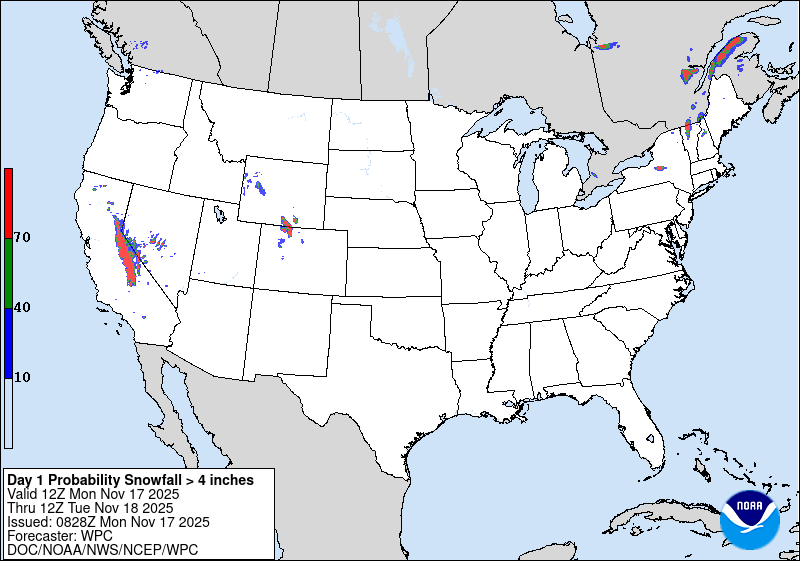
1:48PM: We discussed in our recent road trip forecast the threat for snow in the Sierras, and potential treachery around Truckee for unsuspecting drivers. Well, by the look of the current forecast from the WPC, there should no longer be unsuspecting drivers.
That’s a 70% chance of more than 4″ of snow through tomorrow morning in the high terrain along the California/Nevada border. Get the chains ready!
I don’t have many examples of a road trip that starts in California that doesn’t take four or five days. We found one! It is only an 836 mile jaunt from Monterrey Bay to Provo, and will take us a day and a half. After we get to the free way, we will move pretty quickly, with an average speed of 65.8mph for the entire route. That means day one will target 526.6 miles, wherever that may lead.
DAY ONE (Saturday)
Santa Cruz, California
Wouldn’t you know it, but the one area of the country with significant weather tomorrow is the West Coast. A pretty significant slug of rain is going to arrive in the Central Coast tomorrow morning. Heavy rain and California roadways are not a match made in heaven, and it will be torrential at times from Santa Cruz to Sacramento. Mudslides in this hilly terrain might be a concern. The angle that this disturbance will come on shore will also circumvent the highest of the Sierras. Sure, there will be some flakes around Truckee pass, but there still may be a few showers in northern Nevada. Fortunately, the terrain, while still prone to flash flooding and mudslides, is more forgiving and gives I-80 a wide birth. Most importantly, the rain will be a lot lighter in the Silver State. We will reach Primeaux, which is east of Winnemucca, as our waypoint.
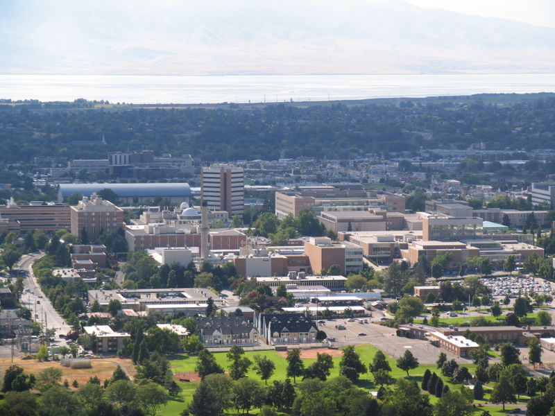
DAY TWO (Saturday) Our little feature from central California is going to merge with a larger waves coming out of the Gulf of Alaska. Showers are probably less likely in eastern Nevada, but as we approach the Wasatch, they become more likely again. Just for fun, it might be a bit snowy in the higher terrain of this particular range as well, though we will be driving at a lower elevation through Salt Lake City and south into Provo. Just a bit rainy, is all.
At the end of October, the North Carolina Coastal Plains saw quite a bit of rain. Fortunately, it started to turn off right before Halloween. In Burlington, there was a trickle on the 30th, and most of it cleared out before the majority of people were awake. Then, on Halloween, it was even nicer, with clear skies and temperatures that rebounded into the 60s. A little chilly for an evening of trick-or-treating, but surely a fair sight better than many were probably expecting. Unless they were looking at the forecast from the Weather Service or Weather Nation, I guess, because those two knocked this forecast out of the park. Actuals: October 30th, .06″ of rain, High 63, Low 49 Halloween – High 62, Low 39
4:08PM: I can tell you that in the Upper Midwest this weekend, we saw some snow. That’s probably not a surprise for a lot of you because there is snow in the forecast for today as far south as the mountains of North Carolina and Tennessee.
9:29PM: Given the last update, I think it may be fairly easy to believe that there is currently no activity in the North Atlantic. Are we done with the tropical season?
We are dangerously close to the weekend. It’s been a soggy week on the West Coast. Will that trend continue?
At 1253PM, PT, Santa Cruz was seeing fair skies with a temperature of 68 degrees. Strong low pressure extended a cool front as far south as about Eureka. There is a lingering marine layer along the coast, but which hasn’t stuck within the bays of the California coast, including Monterey Bay, however an uncharacteristically high dew point suggests that some fog will return overnight. The boundary won’t ever reach Santa Cruz before high pressure begins to build back in. This means that if there is leftover low clouds and fog in the area, it won’t be scrubbed out. Afternoons should still be sunny and mild, even with some haze in the morning. Tomorrow – Cloudy early, then clearing, High 69, Low 53 Saturday – Mostly sunny, High 73, Low 54
TWC: Tomorrow – Sunshine along with some cloudy intervals. High 70, Low 52 Saturday – Intervals of clouds and sunshine. High 74, low 52
AW: Tomorrow – Areas of low clouds early; otherwise, sunny and pleasant High 71, Low 51 Saturday – Pleasant with times of clouds and sun High 74, Low 53
NWS: Tomorrow – Patchy fog before 9am. Otherwise, mostly sunny, High 71, Low 51 Saturday – Sunny, High 74, Low 52
WB: Tomorrow – Partly cloudy in the morning then becoming sunny. Patchy fog in the morning. High 67, Low 54 Saturday – Partly cloudy in the morning then becoming sunny. High 69, Low 55
WN: Tomorrow – Mostly sunny, High 71, Low 51 Saturday – Mostly sunny, High 74, low 52
CLI: Tomorrow – Sunny High 71, Low 51 Saturday – Sunny High 73, Low 50
Clouds are lurking off shore. Will they cause problems? No, probably not, but maybe a bit of fog in the morning.
Rarely do we see a day in which forecasts across the board grade out at an A for everyone. It’s unheard of for a couple of days that were as miserable as they were in Durham a couple days before Halloween. Temperatures lingered in the 50s, suppressed by a feature moving through the Carolinas and smothering the region with rain and wind. On the 28th, the winds gusted to nearly 40mph to go along with the 3/4″ of rain. The weather was miserable, but the weather followed along with what everyone anticipated. This meant this was a three way draw between Victoria-Weather, The Weather Channel and Accuweather. Everyone crowded behind us in a well fought, well done forecast battle. Actuals: October 28th, .76″ of rain, High 51, Low 48 October 29th, .07″ of rain, High 57, low 48
With the newly advertised atmospheric river coming for the Pacific Northwest, there stands to be a bit more interesting weather eventually trickling into the High Plains of Colorado. But how soon?
At 856PM, MT, Greeley was reporting clear skies and a temperature of 43 degrees. Greeley was a pit on the temperature map, as Fort Collins to the west and Fort Morgan to the east were both still in the 50s, while Greeley aligned more with Cheyenne and Laramie, where it had tarted to cool down. Flow is fairly calm, however there is a stream of high clouds showing up south of Denver. The jet fostering low pressure will eventually emerge in the central Rockies, and dig into the high pressure in the Plains. Low pressure will begin to organize in Montana, drawing more warm, dry air through Greeley. With low pressure organizing so far north, there is no threat for rain in the Greeley area. Tomorrow – Fair skies, High 67, Low 30 Thursday – Partly cloudy, High 70, Low 28
TWC: Tomorrow – A mainly sunny sky. High 66, Low 31 Thursday – A few passing clouds, otherwise generally sunny. High 68, Low 31
AW: Tomorrow – Mostly sunny and not as warm but pleasant High 66, Low 31 Thursday – Mostly sunny and windy High 69, Low 29
NWS: Tomorrow – Sunny, High 65, Low 32 Thursday – Mostly sunny, High 67, Low 34
WB: Tomorrow – Mostly sunny. High 65, Low 38 Thursday – Partly cloudy. High 65, Low 36
WN: Tomorrow – Mostly sunny, High 65, Low 35 Thursday – Partly cloudy, High 67, Low 36
CLI: Tomorrow – Sunny High 65, Low 31 Thursday – Partly cloudy High 68, Low 30
It’s such a wildcard this time of year in the High Plains and Front Range. The forecasts are all pretty similar, which means we are all going to be wrong in the same way. Satellite shows a few clouds tonight, generally to the south.
I have a general rule of thumb in the winter. I won’t believe it is done snowing until it is actually done snowing. If there are flurries, I’m just going to keep those flurries in the forecast. There are thermodynamic reasons for this that maybe I can get into at another time. Those thermodynamic reasons don’t apply to light rain showers, but perhaps I should have heeded that “just leave it in the forecast” ethos when forecasting for Elkhart last month. Rain looked like it was on the way out of town when I produced the forecast, but it didn’t leave on Thursday the 23rd, as I assumed it would. It also didn’t leave on Friday, which more of us didn’t think was the future in Elkhart. This soggy end of the week was best handled by the National Weather Service, who collected a forecast win. Actuals October 23rd: .07″ of rain, High 51, Low 37 October 24th, .02″ of rain, High 53, Low 34