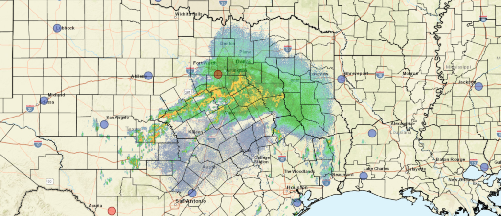
Slow moving Agatha threatens Mexico.

The Pacific hurricane season gets an earlier start than the Atlantic, historically, thanks to abeing a vast body of water that doesn’t see the same changes in temperatures the Atlantic can undergo. It’s not terribly surprising to see Tropical Storm Agatha lurking off the coast of Mexico, but what is surprising is that this feature is expected to back up into the Mexican coast.

Pacific storms tend to start in this area, but the tropical wave they gear up from tend to maintain some momentum, allowing them to shift off to sea. Agatha is nearly stationary, and looks as though she will begin to move poleward earlier than is typical in the Pacific, and back up into Oaxaca.

If there is any good news, it is that Agatha isn’t a large storm. She is expected to become a hurricane before making land fall, which means the wind will be stronger along the beaches of southern Mexico, but the breadth of territory affected by the associated heavy rain should be mitigated. Additionally, that Agatha has backed up and moved northeast fairly recently suggests that storm surge will not be a primary concern either.

Even so, it looks like the storm won’t landfall until Monday, and changes are always possible. Notably, a storm over warm waters always possess the ability to get stronger, though of course, we hope that doesn’t happen.

Severe weather again, but a different story

Last week, a two day storm event brought rough weather first to the Twin Cities on Wednesday, followed by this howling, apocalyptic dust storm to Sioux Falls. There were tornadoes in Minnesota, South Dakota, Nebraska and Iowa, but the real show were a couple of bowing lines of thunderstorms that rolled through each town.

There was more severe weather on Thursday in the Upper Midwest and into the Great Lakes. Severe watches were out from Missouri to Kentucky, and also popped up from Minnesota into Wisconsin and Iowa. There was a particularly different feel to these storms than the ones last week, though, and much of it has to do with the orientation of the upper level pattern.

Last week, the upper level pattern featured a brisk south to north jet streak butting against a stout ridge in the east and situated on the eastern flank of the trough that was allowing the storm system to develop. One of the results was a very narrow opportunity for a warm sector of any consequence, but a lingering “warm front” boundary was the perfect environment for bowing lines and derechos, which is what we got, twice, last week.

This week, the system brought a wider warm sector, and was able to advance cold air. Initially, on Thursday, it lead to some significant hail, such as what I saw in downtown St. Paul Thursday afternoon.

As the storm moved on, the progressive low with access to warm moist air was a ripe environment for tornadoes, of which one struck Gaylord, Michigan. This storm was an EF-3 tornado, which is quite strong in general, but in particular for northern Michigan.

The wave, which again, because it was more open than the one from last week, has continued it’s course, and has allowed the parent area of low pressure into Canada. But again, because it is advancing, has brought cold air in on the back side. Even tonight, there is an ongoing threat of some severe weather thanks to a ranging cold front from the eastern Great Lakes to Texas.

Clashing air masses and strong jet streams are good environments for severe weather. Differing patterns and flows might lead to different results, but as the last couple of weeks have shown, they can all be dangerous.

April forecaster of the month

I’m as shocked as you are to see that I am able to put together this award ceremony in a mostly timely manner. It features a return of last year’s overall champion to a spot at the top. I have to commend Weatherbug on their growth through the years. Very often, they were tied to a Weather Channel forecast, and made changes with deleterious results. Now, in 2021, and at least in April 2022, they seem to have figured things out. Congratulations, Weatherbug!

OutletForecast Wins (year)
National Weather Service3.5
Accuweather2.83
Victoria-Weather2.33
Weatherbug2
The Weather Channel1.83
WeatherNation0.5
Forecast.io

Dangerous weather through the weekend

The weather has certainly been active this spring, and especially so if you consider how busy the Storm Prediction Center has remained since December of last year. Fortunately, since the devastation wrought in western Kentucky, southern Illinois and many places surrounding, we haven’t seen the type of devastation that stays in headlines for days.

That’s not to say the storms have been any less violent so far this year. In fact, there was an EF-4 tornado last month that swept through Winterset, Iowa, claiming the life of 6. That was as strong as the Mayfield, Kentucky tornado. The substantive difference is that Winterset is not as large a town as Mayfield, but the Winterset tornado also did not have as long a track as the western Kentucky storm.

A look at the tornado tracks this year show that, while there have indeed been many twisters this year, most of them were weak, and a lot of them were in Dixie Alley.

By Supportstorm – Own work, CC0, https://commons.wikimedia.org/w/index.php?curid=115162410

By and large, those storms are avoiding the largest population centers, and haven’t been particularly virulent, as tornadoes go.

The pending change is twofold. First, tomorrow, the threat for significant weather targets an area including Tulsa and Wichita. Over the weekend, the threat includes the Dallas Fort Worth area. In general, the storms are going to affect a more populated area. Second, the storms are going to possess a notably higher threat for strong tornadoes. The hatched area in the SPC’s outlook for tomorrow indicates a threat of large (EF-2 or greater) tornadoes in an area. Those are big twisters dangerously close to Kansas City and Oklahoma City, potentially.

Big storms in more populated places remind us that we are definitely in severe weather season, and it is time to keep an extra eye on the sky.

A sluggish, stormy spring

Everyone loves to talk about the weather, as I’m sure you do (you’re here at this site, after all) but depending on where you are this April, you might have a decidedly different conversation. If you are in the southern US, you are probably talking about how stormy this year has been. In the north, you probably can’t get over how chilly things have remained all spring.

For an explanation, we need to look even bigger than we usually do, beyond the confines of the Contiguous US. The answer lies in the jet structure across the United States. As you may already be aware, bigger features are more challenging to move in the atmosphere, and there is an enormous trough that keeps recycling and sustaining itself, and the base of that trough has run across the northern United States.

Take a look at the big picture, the jet forecast for this afternoon.

Typically, if I am looking at the US forecast, I would note the deep trough coming to the west coast was, or even noting the ripple in the northern Great Lakes, but when taking into account the spring writ large thus far, and unfortunately for the coming weeks, the immediate notice is that the larger waves are the ridges bracketing the United States.

There are semi-permanent features in the ocean, certainly, including the Bermuda High, and the existence of the ridges are not unusual. Some things that are factoring into making this spring unusual is the amplitude of the trough over North America. It should be starting to retreat into Canada, bringing some calm to the south, and allowing warmth to filter back north, but the mean trough is instead littered with localized troughs like the one set to upset this weekend.

Another peculiarity is how weak the trough in the Gulf of Alaska is. The Aleutian Low is as permanent s the Bermuda High, but right now, and for a while, this feature has been replaced by transient features moving into the Pacific Northwest. This gives this larger continental wave more breadth, and makes it more difficult to move.

With the mean trough over the US running through the northern tier of states, it is penning cold air that same swath of the country. On the same note, the sun is getting stronger, so warmth is building south of the jet. This clash of air masses at the surface, when coupled with the relatively shorter waves moving across the nation, is making for an active storm season, and a chilly spring, depending on what side of the divide you are on. Eventually, the pattern will break, but there isn’t an immediate sign of that happening quite yet.

Forecasters of the months

It’s been a slow start to the year, especially when it comes to reviewing our months of work. We have February and March to check in on, so let’s not waste time!

February was a very well contested month in the handful of forecasts we had. There was one outlet that lagged well behind, but we won’t embarrass them. Instead, we will point to Weatherbug, who had the solid victory in the month of February.

March was a little bit more snug at the top. Weatherbug was pipped in the end, with only half a point to spare. Good news on this tax day, as the National Weather Service took our tax dollars and turned it into a monthly W.

OutletForecast Wins (year)
National Weather Service3
Victoria-Weather2.33
Accuweather2.33
The Weather Channel1.33
Weatherbug1
Forecast.io
WeatherNation

The west cools down

Persistently, for years, the abnormally warm part of the country has been the west. It’s exasperated the drought, fanned wildfires and brought hundreds of millions of dollars of destruction to the region. Finally, the upper level feature preparing to bog down over the western US will be a trough. The long wave, slow moving trough over the western US will ensure below normal temperatures for a large chunk of the Pacific Coast and Rocky Mountains.

The coldest stretch will be in the second week of the month, and there is a good deal of forecast confidence in the below normal temperatures.

The colder weather out west will turn around by the end of the month, as the feature will start to propagate and surely bring severe weather to the Plains, given the temperature change over such a narrow swath of land, showing up even in these long term outlooks. Despite the coming warm up as this broad trough starts moving, the overall outlook for the month of March is for below normal temperatures in the west.

Rain will come to the Pacific Northwest but the trough is going to be far enough east that low pressure will generally develop in the Rockies. Not necessarily a drought buster for California, but perhaps an extension to the ski season will be coming soon.

Awards season

We are halfway through February, and the schedule has still not permitted time to reward the forecasters of the month in December and January, let alone the forecaster of the year for 2021. Naturally, we have an opening just before a fairly significant weather system sets to blast the south central US. I’ve been giving a lot of updates to friends on that, so it’s time to take a step back to review where we have come from.

First, I will start with the December champion, because I’m sure that will be top of mind for everyone, and I like to give a shout out when an unusual champion makes a stride. Forecast.io won the month of December. Good for them!

With that in mind, we can also award the title for Forecaster of the Year. It was close for a lot of the year, and our winner was even in second place until about August, but then they surged and won going away. The Weather Channel was the strongest forecaster in 2021, and it’s hard to dispute this as a fluke. Way to go, TWC, you were dominant. Kudos to Weatherbug, who had the highest highs, earning the most individual forecast victories, but sloughing off when they weren’t at the top of the heap. It’s about consistency, not just the wins.

OutletForecast Wins (year)
Weatherbug16.99
Victoria-Weather12
The Weather Channel11.66
Forecast.io10.66
Accuweather8.83
National Weather Service6.16
WeatherNation1.66

And now, finally, we can conclude with the champion for the month of January in 2022. We were awfully light on the forecasting to start the year, but we can say, with confidence, that The Weather Channel didn’t let off the gas pedal, just because they started the new year. Congratulations for all the good news, Atlanta!

OutletForecast Wins (year)
The Weather Channel1.33
National Weather Service1
Victoria-Weather0.33
Accuweather0.33
Weatherbug
Forecast.io
WeatherNation

Lessons learned in this stormy December

The weather took a terrible turn this past month, with dozens killed in a tornado outbreak centered around the lower Ohio Valley, and strong winds and isolated tornadoes coming at the an unusual time, and bringing destruction to the Upper Midwest. One question that was raised, particularly after the Mayfield tornado occurred, and the samage and loss of life was assessed was what could have been differently.

From a meteorologist’s standpoint, there wasn’t much. There was at least a 20 minute lead time in Mayfield, for example which was certainly enough time for shelter to have been taken, even for some people in the small town to find safety in a structure other than the destroyed candle factory where so much loss occurred, if they didn’t think the building itself was safe.

Meteorologists used every tool they had at their disposal, and they did so in a timely, generally accurate pattern. Not only was there an outlook for severe weather in western Kentucky, but it was posted as a moderate risk. There were tornado watches for hours ahead of time, and Mayfield itself was in a tornado warning with a confirmed tornado, before the warning was upgraded to a tornado emergency, with 15-20 minutes of lead time. The tornado emergency, which doesn’t come until after a tornado warning is issued, gave residents almost twice as much of a lead than a tornado warning typically affords.

The issues are educational and psychological. With as much lead time, and as quality as the forecast was with a good handle on the live situation as meteorologists had, it filters back to the populace to be their own own last line of defense. Praise, rightfully, has been given to local NWS and television meteorologists, but their calls for safety went unheeded by some.

Some answers to the source of the issues can be seen in the response to the storm in the Upper Miwest a week later. There was a great deal of concern ahead of time for a serial derecho, with some tornadoes and even strong wind outside of the heaviest storms. Tornadoes did hit several communities from Nebraska to Iowa, Minnesota and Wisconsin, but the track was a hair further south than had been anticipated in a lot of forecast outputs. To hear many residents of the Twin Cities tell it, the forecast was completely off, even though the storm had been significant, with confirm tornadoes one county outside of the greater metropolitan area.

There is a segment of the population that gives weather forecasts zero margin for error, and even though most broadly consumed forecasts are for a region, rather than a point, a forecast’s validity for many users is only accurate insofar as it is accurate for their location. The SPC said there was a chance for a tornado within 25 miles of the metropolitan area This forecast was indeed accurate, but some residents likely disagree with that assessment, as there were no tornadoes IN the metro area.

If there is a preconditioning towards disbelief of a forecast, the forecasts are not going to be regarded, and that is generally OK with me. If you want to be caught without a coat or an umbrella, that is your prerogative, but also, a warning is not the same as a forecast, and the messaging reflects that, even is the reception doesn’t.

In this case, it comes down to education. While forecasts are broad, various updates and warnings become more focused as severity increases. This has always been the case, but even my closest friends and family can’t always figure out the difference between a watch and a warning. If that’s the case, adding the extra layers of a reported tornado warnings and tornado emergencies lose their efficacy. Under no uncertain terms, these definitions should be taught in schools, as should local geography. If you know where you are on a local map, you can look at radar yourself and “do your own research” if you don’t believe meteorologists.

Another phenomenon of human psychology, especially as it pertains to warnings and the weather, is described well in the fable of the Boy Who Cried Wolf. Even in Mayfield, there was a tornado warning earlier in the day, and it is alleged that the fact that the first warning bore no harm to Mayfield perhaps led management of the candle factory to disregard the second forecast. A look at a radar would have shown that another storm was indeed on it’s way, and an education in the parlance of warnings would have shown that this second warning was actually a tornado emergency, and significantly more serious.

Meteorologists and anthropologists for years have known that repeated warnings lead to increased popular dismissal of the warnings, and the National Weather Service has responded by reformatting warnings to base them on polygons, rather than strictly by county. They have altered the text in warnings, and added tornado warnings to reflect severity, or to focus the warnings even further on individual locations. At some point, we need to focus on education to make sure these messages are understood and acted upon appropriately.

November Forecaster of the Month

It’s hard to remember much about November most of the way through December, especially because December has been such a historic month. The upper level pattern was strong and undulating, reminiscent of an active spring, rather than the middle of December. One of the most devastating and perhaps longest track tornadoes came to the lower Ohio Valley, where there were deaths in Arkansas and Illinois, but particularly in Kentucky, where 76 lost their lives. The tornadoes did the most damage to Mayfield and Dawson Springs in Kentucky, but certainly, other communities are hurting.

That same storm was responsible for dumping up to 20 inches of snow on parts of Minnesota and Wisconsin. Then, a few days later, another strong system tracked into the same area, and serial derechos spread across the High Plains and Upper Midwest. In addition to winds that were approaching 100mph, there were tornadoes recorded in December for the first time in Minnesota and Wisconsin. Fortunately, the human impact was a lot less significant with this storm than the one that struck Mayfield and communities surrounding.

It’s been a very difficult month.

November was a more relaxed month for weather headlines, and it went particularly well for The Weather Channel, who easily won the month, and will be tough to beat for the year’s prize.

OutletForecast Wins (year)
Weatherbug14.99
The Weather Channel11.16
Victoria-Weather11
Accuweather8.83
Forecast.io8.16
National Weather Service6.16
WeatherNation1.66