There are a couple of Fayettevilles of note in this country of ours. For today, we will visit the North Carolinian version of the two.
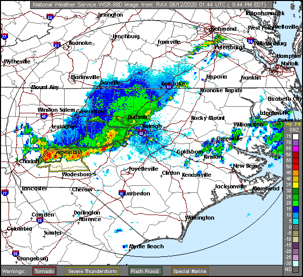
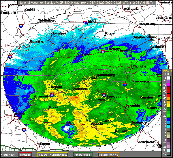
At 953PM, ET, Fayetteville was reporting overcast skies and a temperature of 76, with an incredibly sultry dew point of 73. The exhaustingly humid air was ahead of a line of storms extending from Raleigh to Norman and west towards Norwood, along which there were some severe gusts. These storms would likely inch into Fayetteville before the night was through.
The wet weather is tied to a slowing cold front, associated with the remnants of Cristobal, who is now moving through Hudson Bay towards Baffin Island. This will lend to some lingering showers and storms in and around eastern North Carolina tomorrow, especially in the afternoon. Robust surface high pressure is moving in from the north, but an upper level trough is going to generate a surface perturbation that will ripple along the southern flank of the ridge, and will reinvigorate the threat for showers and storms in eastern North Carolina on Saturday. Unfortunately, that truly crisp air looks unlikely to make a lasting impression.
Tomorrow – Isolated storms, otherwise muggy and mostly cloudy, High 83, Low 74
Saturday – Mostly cloudy, chances of rain and storms, High 83, Low 68
TWC: Tomorrow – Rain showers early with overcast skies later in the day. High 82, Low 70
Saturday – Sunshine and clouds mixed High 84, Low 64
AW: Tomorrow – A thick cloud cover and humid with a couple of showers and a heavy thunderstorm; watch for flooding High 83, Low 72
Saturday – Cloudy most of the time with a shower or heavy thunderstorm in the area; watch for flooding High 85, Low 67
NWS: Tomorrow – Scattered showers, with thunderstorms also possible after 11am. Mostly cloudy High 83, Low 72
Saturday – A chance of showers, with thunderstorms also possible after 2pm. Partly sunny High 84, Low 67
WB: Tomorrow – Cloudy with scattered showers with a slight chance of thunderstorms, High 81, Low 72
Saturday – Partly sunny. A chance of showers and thunderstorms in the afternoon, High 82, Low 67
WN: Tomorrow – Mostly cloudy with scattered showers, High 83, Low 71
Saturday – Partly cloudy with scattered showers, High 84, Low 67
FIO: Tomorrow – Rain in the morning. High 82, Low 71
Saturday – Partly cloudy throughout the day. High 82, Low 66
Some mixed messaging with the forecasts to round out the week. Rain? No? We’ll see! The radar for tonight continues to look active, though.