Everyone knows that it’s getting colder when December rolls around, so to start the month with a forecast that feature descending temperatures is insult to injury. It’s made worse by forecasts being warmer than what ultimately verified, as was the case in Tulsa at the beginning of the month. A cold front that was unencumbered with moisture brought brisk winds and chilly temperatures progressively through our forecast period. It started colder than expected and stayed that way. Accuweather had the best line on the chilly weather, not that it was a great forecast. Actuals: December 2nd, High 59, Low 44 December 3rd, High 43, Low 29
Back to the Tar Heel State for a forecast in Goldsboro. A lot of ‘boros in North Carolina.
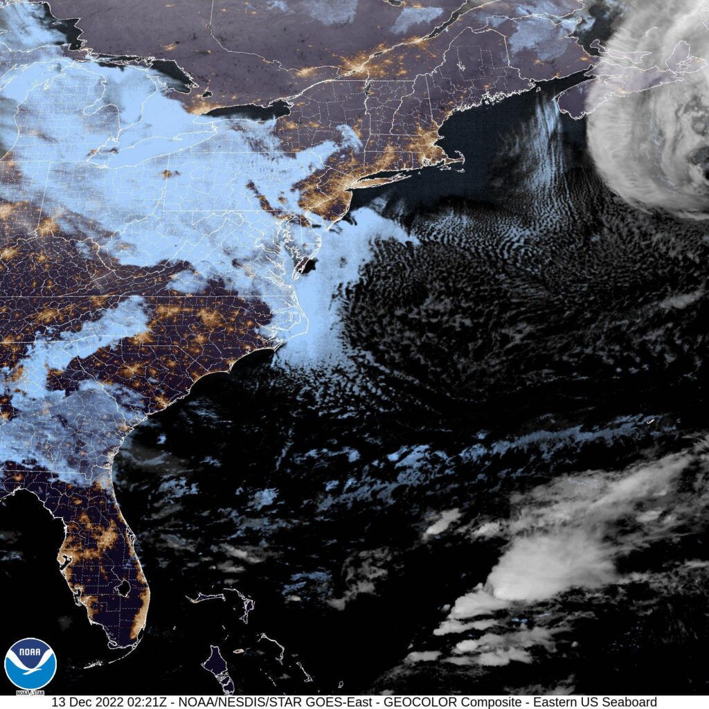
At 855PM, ET, Goldsboro was reporting mostly cloudy skies with a temperature of 42 degrees. A massive, deep area of low pressure is on it’s way north towards Nova Scotia, and is dangling a cold front that is primarily inactive onshore, save for a thick shield of clouds well to the north of the boundary, and more scattered activity in the Carolinas before the boundary is visible in south Georgia. If the clouds don’t fill in fast enough, Goldsboro may approach freezing, but tomorrow morning will be cloudy. While the low headed to Nova Scotia is stout, it is going to be quickly forgotten in the CONUS. A strong trough moving out of the Rockies is going to bring a warm front into the region. The feature is going to be a headline maker in the middle of the country with winter weather in the Northern Plains, and a perturbation in the southern part of the boundary is already bringing severe weather to the Southern Plains tonight. The severe storms will continue into the lower Mississippi Valley tomorrow, with continued storm activity along the Gulf Coast Wednesday. The severe storms and most unstable air will stay south of the Carolinas, but in the evening on Wednesday, rain will arrive in Goldsboro, leading to a soggy end of the week. Tomorrow – Cloudy early, then clearing, High 49, Low 30 Wednesday – Increasing clouds late, some showers before midnight, High 52, Low 28
TWC: Tomorrow – Sunshine. High 50, Low 29 Wednesday – Cloudy skies (Late rain) High 51, Low 27
AW: Tomorrow – Plenty of sun High 51, Low 31 Wednesday – Cloudy and chilly; a passing shower in the afternoon High 50, Low 28
NWS: Tomorrow – Sunny High 49, Low 29 Wednesday – Partly sunny, High 50, Low 29
WB: Tomorrow – Sunny, High 47, Low 30 Wednesday – Mostly cloudy, a slight chance of rain in the afternoon, High 47, Low 31
WN: Tomorrow – Sunny, High 48, Low 31 Wednesday – Partly cloudy, High 49, Low 30
FIO: Tomorrow – Clear throughout the day. High 48, Low 31 Wednesday – Mostly cloudy throughout the day (Late rain). High 49, Low 28
Here is a look at the satellite, with the Carolinas in the happy middle between sheaths of overcast.
Rain was on the way when we looked at Decatur at the end of the last month, and arrive it did. An inch and a third fell the morning of the 30th, sending temperatures down to below freezing by the end of the day. It was dry, fortunately, to start December, though it was cooler than it had been by quite a bit just two days before. Weatherbug nabbed this transitional forecast victory. Actuals: Nov 30th – 1.32″ of rain, High 62, Low 31 Dec 1st – High 50, Low 26
We are 4 days into December, and it’s already snowed twice at the Victoria-Weather headquarters. Let’s see how it is going in North Carolina.
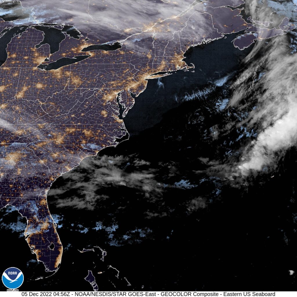
At 1130, ET, Durham was reporting a temperature of 39 degrees with clear skies. An elongated ridge ran along the coast, with the southwestern end nosing into the Carolinas, keeping Durham dry this evening. The tenuous existence of the ridge will make the Carolinas susceptible to wet weather over the next couple of days, despite the clear skies at present. There is a low level perturbation that is moving east out of northern Alabama tonight, and will attempt to wrap under the southern Appalachians and into the Carolina Plains with limited success. A more notable feature moving through Canada will dangle a cold front that eventually catches up to the perturbation lurking in the southeast. This boundary will more effectively tap into the moisture drawn in tomorrow morning, leading to some clouds and light rain throughout the day on Tuesday. Don’t expect the front to ever reach Durham, however, so a dramatic cool down will be averted. Tomorrow – Partly cloudy, High 55, Low 32 Tuesday – Mostly cloudy with some light rain, High 59, Low 46
TWC: Tomorrow – Considerable cloudiness. High 55, Low 29 Tuesday – Cloudy with showers High 58, Low 45
AW: Tomorrow – Some sunshine giving way to clouds High 54, Low 29 Tuesday – Cloudy with a passing shower High 58, Low 44
NWS: Tomorrow -Partly sunny, High 53, Low 29 Tuesday – A chance of rain before 8am, then showers likely, mainly between 8am and 2pm. Cloudy High 59, Low 43
WB: Tomorrow – Mostly cloudy, late rain High 53, Low 30 Tuesday – Cloudy. Showers mainly in the morning. High 59, Low 45
WN: Tomorrow – Partly Cloudy, High 53, Low 31 Tuesday – Mostly cloudy with showers likely, High 57, Low 43
FIO: Tomorrow – Partly cloudy throughout the day. High 51, Low 35 Tuesday – Rain until night, starting again in the afternoon. High 59, Low 484
Satellite tonight shows whispers of clouds over Durham, but a pleasant day is promised ahead, unless you ask Weatherbug.
Today’s forecast takes us to another part of the country that is known for strong spring time weather, after Decatur earlier this week. Will Tulsa see cool and calm like Decatur did, or will we see something different?
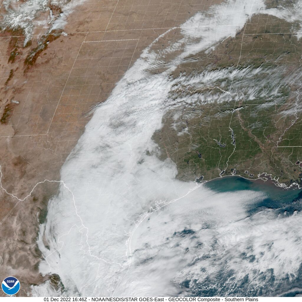
At 953AM, Tulsa was reporting a brisk 42 degrees with mostly cloudy skies and wind gusting over 20mph. The jet was quite strong, which is not unusual for the time of year, and ridging through the center of the country. High pressure centered over the Ohio Valley was generating the brisk wind on it’s back side, with return flow bringing some of the cloud and chances for rain in the southern Plains. Over the Rockies, this same strong jet is producing a trough, which hasn’t fully materialized into a surface low yet, thanks to the local terrain. Expect a deep area of low pressure to emerge over South Dakota tomorrow morning, enhancing the windy conditions over Tulsa. Flow will be from the southwest, with high pressure still nosing into the northern Gulf, and this will staunch moisture flow into Oklahoma. The associated cold front will arrive late Friday with similarly gusty winds, and a significant Saturday cool down. Tomorrow – Passing clouds, breezy, High 67, Low 48 Saturday – Partly cloudy, colder but less windy, High 49, Low 32
TWC: Tomorrow – Overcast. High 65, Low 46 Saturday – Partly cloudy skies. High 49, Low 33
AW: Tomorrow – Mostly cloudy, windy and warmer High 64, Low 47 Saturday – Mostly cloudy and cooler High 48, Low 30
NWS: Tomorrow – Mostly cloudy, High 66, Low 46 Saturday – Mostly sunny, High 51, Low 35
WB: Tomorrow – Mostly cloudy in the morning, then becoming partly sunny. Breezy, High 65, Low 47 Saturday – Mostly sunny, High 50, Low 37
WN: Tomorrow – Partly cloudy, High 65, Low 47 Saturday – Partly cloudy, High 46, Low 36
FIO: Tomorrow – Windy in the morning and afternoon. High 64, Low 44 Saturday – Windy overnight. High 53, Low 33
The high on Saturday will probably come at midnight. The WeatherNation hourly forecast doesn’t extend that far out, but they shouldn’t be too far off. Check out the satellite, showing clouds wrapping around high pressure in Texas and Oklahoma.
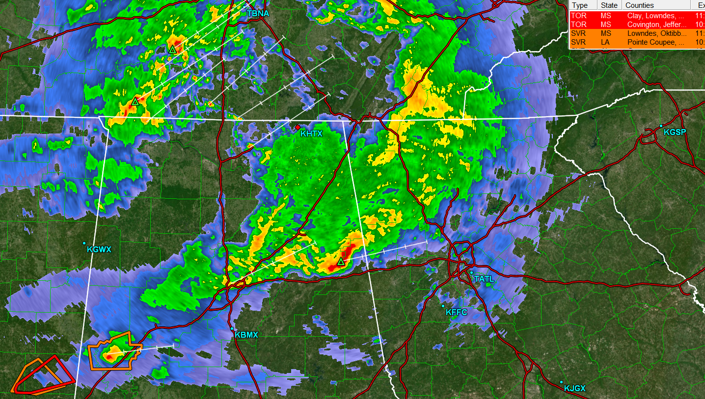
Tonight’s forecast takes us to an area under threat for severe weather. The strongest storms are in Mississippi, but northern Alabama remains in a slight risk for severe weather.
At 853PM, CT, Decatur was reporting cloudy skies and a temperature of 63 degrees. Low clouds and cool temperatures across northern Alabama suggest that the threat for severe weather is likely over, however, there is plenty of rain and thunder across central Tennessee that looms as a possibility overnight. Flash flooding is always a possibility, but the strong winds and tornadoes will remain to the southwest. The parent area of low pressure associated with tonight’s storms is moving north of the Great Lakes, while a secondary vorticity maximum was centered over western Kentucky, providing the atmospheric spin, and emphasis on moisture importation to the region tonight. As a unit, this feature is progressing swiftly to the east, and the threat of rain should be clear of Decatur by sunrise. The high pressure that builds behind this system will be stout but transient. The next two days will be cool and clear, a recovery after a rainy and stormy night. Tomorrow – Rain ending early, then becoming sunny, High 58, Low 30 Thursday – Sunny, High 52, Low 27
TWC: Tomorrow – Some clouds in the morning will give way to mainly sunny skies for the afternoon (early rain). High 62, Low 33 Thursday – Some clouds in the morning will give way to mainly sunny skies for the afternoon. High 52, Low 29
AW: Tomorrow – Cooler with clouds giving way to sun; breezy in the afternoon (Early Rain) High 60, Low 34 Thursday – Sunshine, High 52, Low 29
NWS: Tomorrow – Partly sunny, then gradually becoming sunny, (Rain early) High 67, Low 36 Thursday – Mostly sunny, High 51, Low 31
WB: Tomorrow – Much cooler, mostly sunny (Early rain), High 62, Low 33 Thursday – Partly cloudy, High 50, Low 30
WN: Tomorrow – Partly cloudy with showers and scattered storms, High 64, Low 36 Thursday – Partly cloudy, High 51, Low 32
FIO: Tomorrow – Heavy rain overnight and in the morning. High 63, Low 34 Thursday – Partly cloudy throughout the day. High 51, Low 29
Temperatures tomorrow will be falling through the day as high pressure settles in. Some rain looms to the northwest, but mercifully, none of it will bring terrible storms.
We are a couple of days from the end of the month, but with a handful of forecasts coming up, and a looming threat of severe weather coming tomorrow, I thought we might as well grab some time now to reward the top forecaster from the past month. The top spot this month belonged to the fine folks at the National Weather Service, who took the prize, thanks to good old fashioned consistency.
If any one traveled around the western Great Lakes for Thanksgiving, you will be well aware that the weather was very good. In Racine, it was generally sunny, though with a few spots of clouds here and there for the two days before Thanksgiving, and it was warm. In fact, temperatures exceeded expectations on Wednesday, climbing all the way up to 55. Now that is something to be thankful for. Victoria-Weather navigated the low temperatures in Racine the best, which was the difference in our Turkey Day triumph. Actuals: Tuesday – High 47, Low 24 Wednesday – High 55, Low 30
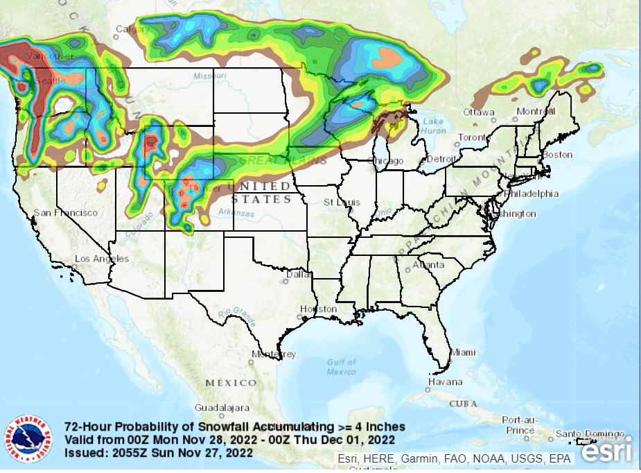
After a relatively docile November, the end of the month is going to provide quite a bit of climactic intrigue. Low pressure is already spiraling through the Rust Belt on it’s way to New England. It will make for a wet trek home from Thanksgiving for a lot of people, and even includes some rumbles of thunder in western Pennsylvania, and will likely bring snow to interior New England this evening.
This storm is a hassle, definitely, but a real show is massing in the northern Plains. The next trough is going to dip to the south and give rise to a strong area of low pressure developing in the middle of the country. Things will really come together on Tuesday evening, seemingly from nothing.
The center of low pressure will slide north of the Canadian Border on Tuesday, with a slow moving cold front extending from southern Minnesota to the Denver area, with snow showers expected along the boundary on Tuesday. As the feature shifts into Manitoba, things will really take off. Moisture will start flowing northward as the low taps into the Gulf, while an undercutting area of low pressure emerges in the mid Mississippi Valley. This will lead to some higher output snow bands on the northeastern stretch of the low. Some spots from southeastern Minnesota to the Upper Peninsula of Michigan will see 6+ inches of accumulation.
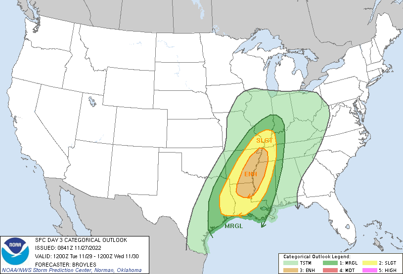
Also, with the atmospheric machinations and additional moisture, there is a looming threat for severe weather in the Lower Mississippi Valley. The undercutting low will produce a cold front of it’s own, and this will be the focal point for severe weather. Strong straight line winds are going to be a wide ranging problem, but the twisting and turning of flow in the region will also induce an seasonably high tornado threat.
The highest threat will be around sunset, just before and after, stretching from the Bootheel of Missouri to about Natchez, Mississippi. I would expect some supercellular storms in eastern Arkansas and northeast Louisiana, putting places like Monroe, Louisiana at risk for tornadoes. Things will aggregate into a line, bringing a more widespread straightline wind threat to western Tennessee and Mississippi, though embedded tornadoes are still going to be possible through the evening. The severe threat won’t last into the night, but rain and storms will be an issue in Alabama, Georgia and most of the eastern Seaboard on Wednesday.
The target area for severe weather is pictured below by the SPC.
It’s definitely going to be a nasty day for a lot of people on Tuesday, whether it be the snow in the north, the severe weather to the south, or the cold rain in between.