Many lamented the loss of Forecast.io across the internet, and perhaps in honor of their impending retirement, Forecast.io did better than normal. That is to say, they finished in a tie for 4th. Lewiston withstood a Pacific storm that brought precipitation to the Cascades and Northern Rockies, and eventually to the middle of the country. Lewiston only had about an eighth of an inch of rain between the two days of our forecast period at the end of the year, and temperatures lingered just below 50 degrees. All told, it wasn’t nearly the story seen outside of the region between the Ranges. The Weather Channel rang in the new year with a victory. Actuals: December 30th, .04 inches of rain High 50, Low 37 December 31st, .09 inches of rain, High 46, Low 36
There are phrases that have been around the meteorological lexicon for years, and then get adopted into the media, and become part of what many find to be a sensationalized parlance. The polar vortex stands out to me, as does the bomb cyclone. These are real, definable things that suddenly take on a more ominous tone because they are uttered on the news regularly.
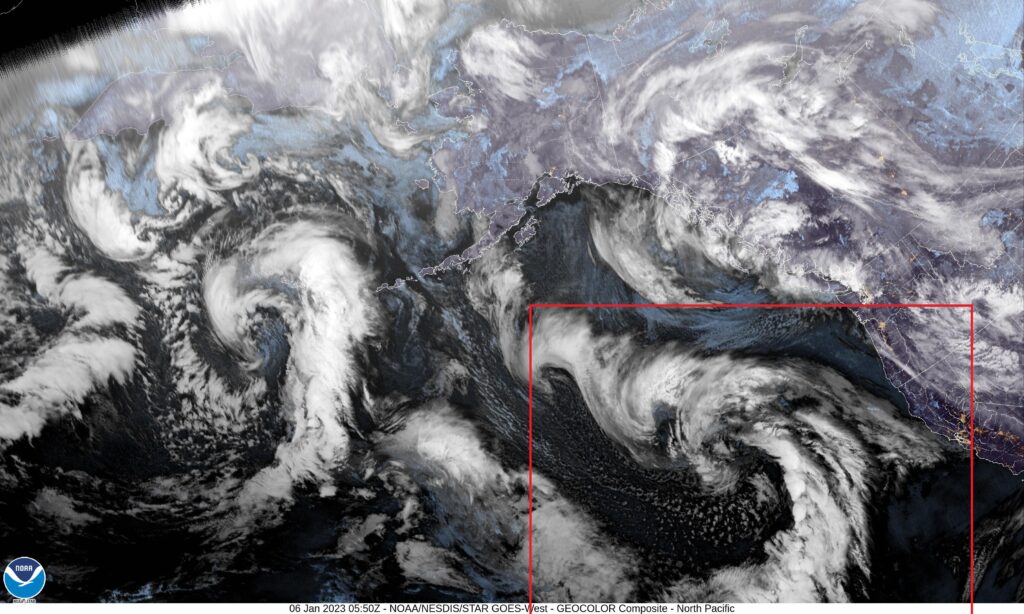
Right now, we are hearing about the “Atmospheric River”. Allow me to show you what that result of the atmospheric river is on satellite. It’s unusual, I think, to look at satellite over the north Pacific, because it isn’t somewhere we usually look at, and the perspective is a tad wonky, but here it is.
And that, boxed in red, is an area of low pressure, showing off the typical comma shaped cold front with a little warm front evidenced as angling towards San Francisco Bay. It’s not particularly unusual, but the discussion surrounding this feature is probably amplified by the persistent drought, which has rendered rainmakers rare over the last several years, and ongoing concerns over climate change flaring anxiety over every weather phenomenon.
The jet, in response to oceanic circulations, tends to rise and form a ridge at the California Coast, leading to the semi permanent Gulf of Alaska low (which feeds moisture into British Columbia and the Pacific Northwest with regularity) and a semi permanent area of surface high pressure west of the Baja Peninsula. In the winter, the jet is more apt to dig a little bit further south, because the cold California coastal waters don’t cause the atmosphere to differ as extensively as happens in the summer, and that coastal ridge can break down.
So the jet sinks south, and a regular old area of low pressure moves into California. It is coming off the ocean, so it will be laden with moisture, and it is interacting with the terrain, so it will dump a lot of precipitation, especially in the Sierras. This will do a lot of work in refilling dried reservoirs as the snow melts in the spring, and is how California usually maintains a sustainable quality of life. The southern source of the jet has led, in the past, to some “atmospheric rivers” to be dubbed “the Pineapple Express”.
All they are, really, is a more southerly jet that brings consequential weather to the West Coast. he phenomenon isn’t strange, but the location is, made a little bit more unusual by the recent climatology.
We’ve made it through 2022, and are looking forward to 2023. The end of the year saw The Weather Channel claim the final prize, though the newly retired Forecast.io was close behind. The Forecast.io site is already shuttered, and there are widespread lamentations over the DarkSky app. After the few years we’ve used that site as one our verification comparables, I can confirm that it was one of the easiest to use, and most readable, accessible outputs. On the other hand, it was consistently the least accurate, proving the continued value of meteorologists inserting their input in the process. In fact, despite Forecast.io’s strong end, it was the worst outlet of the year, and it wasn’t close. Alternately, the National Weather Service was abominable in December, but were the top forecast of the year. They had a steady hand throughout the season, racking up only the third most individual forecast wins of the year, but still won the year’s title. It was made closer by their sloppy end, but the first 11 months were so good, it didn’t matter. Congrats to the Weather Service on their year, and a Happy 2023 to everyone!
This forecast is coming out too late to factor into our standings or anything like that, but it will serve as a send off to the newly retiring Forecast.io. Starting on January 1st, we will be using Clime. I would love to use Fox Weather, but they still haven’t managed to produce a website with local forecasting.
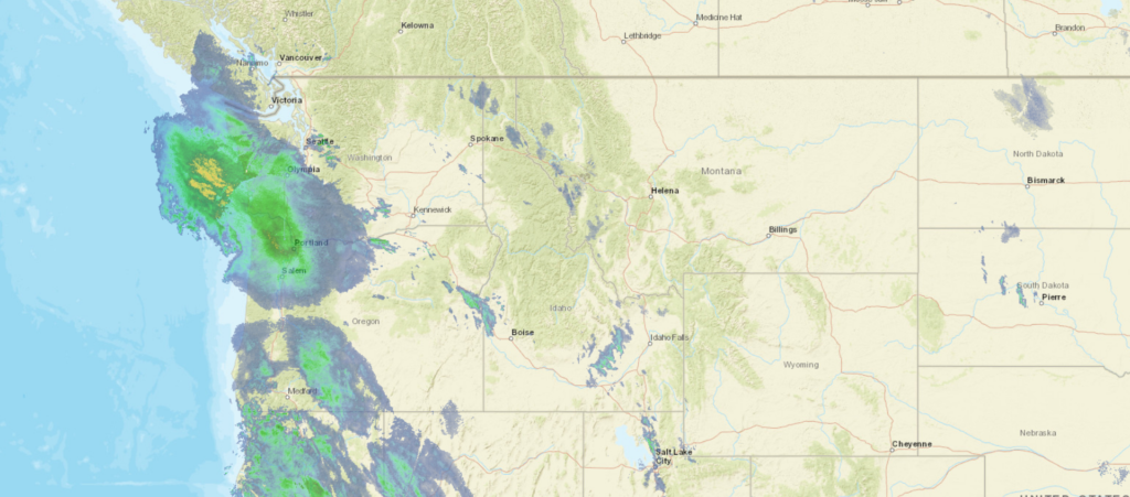
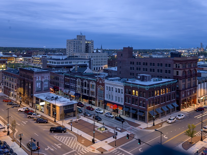
At 956PM, MT, Lewiston was reporting cloudy skies with a temperature of 42 degrees. While the west didn’t experiences the frigid temperatures seen in the eastern 2/3 of the country over Christmas, a deep trough has set up over the Rockies, with a strong jet, a so called atmospheric river, pumping moisture into the Pacific Northwest. Winter Weather advisories have been issued just to the north of Lewiston, with more to the south. It remains quite likely that snow is on it’s way in Lewiston as well. The next round of wet weather is already Pressing ashore in western Washington and Oregon, bringing steady precipitation to the Cascades. Lewiston’s presence between the Cascades and the Rockies of western Montana will spare some of the more significant snows, as will temperatures that will flirt with freezing. Additionally, a prominent surface feature is forecast to organize in the Great Basin, south of Idaho through the next two days, sapping Lewiston’s moisture and ultimately bringing colder temperatures as the snow ends. Nevertheless, snow with a bit of light rain mixed in are possible from mid morning tomorrow and onward for about 24 hours before clearing arrives. Tomorrow – Light snow with a bit of light rain, High 47, Low 37 Saturday- Early precipitation, generally falling as rain, High 41, Low 32
TWC: Tomorrow – A mix of clouds and sun early, then becoming cloudy later in the day (rain/snow late). High 48, Low 36 Saturday – Considerable cloudiness (Early mixed precip). High 45, Low 35
AW: Tomorrow – A couple of showers of rain or snow in the morning; otherwise, mostly cloudy High 51, Low 37 Saturday – Mostly cloudy High 46, Low 37
NWS: Tomorrow – Rain, mainly before 7am. High 50, Low 37 Saturday – Mostly cloudy, High 45, Low 36
WB: Tomorrow – Mostly cloudy with rain or snow in the morning then mostly sunny in the afternoon. High 47, Low 36 Saturday- Partly sunny, High 45, Low 37
WN: Tomorrow – Partly cloudy with isolated showers, High 49, Low 39 Saturday – Partly cloudy, High 42, Low 34
FIO: Tomorrow – Light rain throughout the day. High 47, Low 37 Saturday – Mostly cloudy throughout the day. HIgh 44, Low 34
Clouds and the amount of precipitation in Lewiston will all play a factor. I think there is a huge bust potential overall with this dynamic system in the mountains. I am banking on it skewing colder. Look at all the rain coming for the Cascades at this hour!
My parents live part of the year in south Florida, due east of Fort Myers Beach, which was among the hardest hit areas by Hurricane Ian this September, along with Sanibel Island. Inland, in places like Estero, Bonita Springs and the south side of Fort Myers, the lack of coastline prevented the storm surge and flooding that proved so catastrophic to Fort Myers Beach, wiping the beloved Time Square shopping area off the map.
Southwest Florida had a very good run, avoiding hurricanes for a very long time. That was true until 2017, actually, when, after battering the Caribbean and the Florida Keys, Hurricane Irma made landfall at Marco Island, and moved through the Peninsula from south to north. Ian made landfall further to the north, and was more specifically aimed at the Fort Myers area.
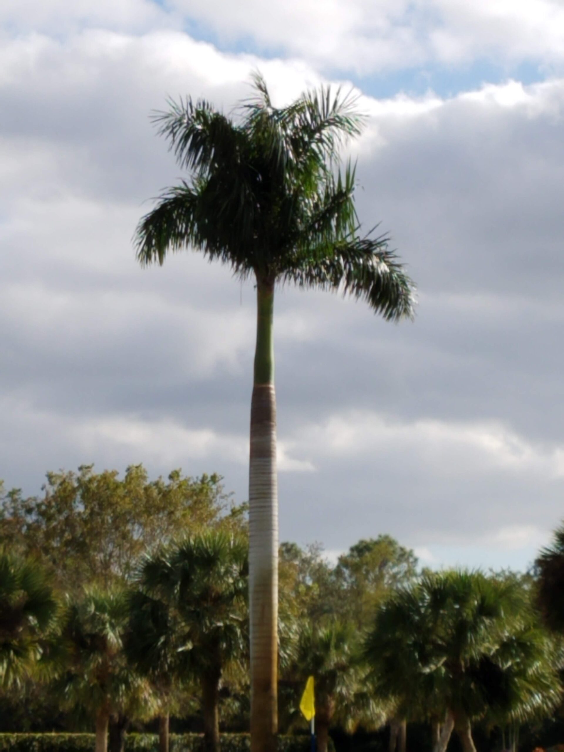
There was a grove of palm trees that I particularly admired the first time I was down there, about 10 years ago. 3 royal palms stood near the pin of one of the short holes of the course, and were a photogenic and stately landmark at the facility. I took a picture and had it as my phone background for a while.
Trust me, they were stately. This is a screen shot of a years old picture, and don’t do them justice. 5 years after this picture was taken, Irma came to pass. Irma decimated the foliage of Estero. The tree cover was significantly less around the facility, and what trees weren’t taken down were defoliated. Cypresses were laid bare, and stood out the most. The palms that weren’t felled stood proud. Of that trio, that was the case.
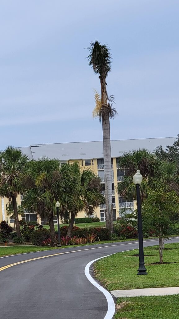
Only one of the palms survived Irma, and the tall palm in the trees behind the stand, for example, was also lost. But this pine stood as a stately welcome and a great object to aim at from the tee box.
Ian was a different beast. The damage with Ian produced more structural damage. My parents’ building was ok, though the carport was destroyed. Throughout the town, there are still tarps on roofs. Even buildings adjacent to their facility had unrepaired roof damage. The most noticeable damage to a visitor was in the signs for various venues. There was a Waffle Us and a Chi i around town, with letters gone and yet unrepaired. Still more signs were completely decimated, living only a ring where a corporate brand had once been.
That remaining palm though, stood tall. He definitely looks worse for wear, and is a stoic reminder of what Irma and Ian have wrought on the region.
Merry Christmas! Here in South Florida, temperatures haven’t climbed above 60 since we arrived, temperatures which rival those of our forecast for Goldsboro back in the middle of the month. It’s colder there now, but on the 13th and 14th, temperatures lingered in the mid to upper 40s for highs, and dipped below freezing in the mornings. It seems like this might end up being Forecast.io’s last victory. End of an era. Actuals: December 13th, High 48, Low 30 December 14th, .01 inches of rain High 46, Low 27
You… you want to go for a drive? Tomorrow, in the Ohio Valley? Good luck with all that. If you insist on taking this trip it will cover 287 miles and in good conditions, would take a little over 5 hours. These will not be good conditions. The pace would be set at about 55mph, but it will be slower driving tomorrow through this part of the country. I can’t recommend in stronger terms that you do not actually make this drive tomorrow.
Decatur, Illinois
We’re watching a massive storm, with blizzard implications in the northern US charging towards the Great Lakes. The system will look like a typical summer time system, and the cold front will charge into Decatur shortly after noon. We’ll already be about to Effingham when it arrives, and this snow will arrive with some intensity. Snow totals will be lighter because there are warmer temperatures than further to the north, but winds will be very strong. There could be a little bit of rain before we see clear skies again, think around Evansville, with dry conditions returning in Kntucky. While in Bowling Green, though, all hell will again break loose, so hunker down.
The threat for rain was introduced in every forecast for Durham back in the first week of December, but It held on to the very end of the forecast period. This allowed forecasters who skewed to a warmer forecast to get a a little bit closer to that perfect forecast. The warmest outlet of them all was Victoria-Weather, and our forecast turned out to be very good. Actuals: December 5th, High 55, Low 31 December 6th, .08 inches of rain, High 60, Low 48
A massive feature moving through the center of the country, the second this month, is bringing blizzard conditions to the Northern Plains, but it will be remembered for quite some time for the path of destruction it is weaving across the southern US.
The storms started yesterday, with tornadoes striking the Dallas-Fort Worth metro, including causing 5 injuries at a Sam’s Club and mall in Grapevine.
Check out some of the photos of damage from storms around the DFW area earlier this morning. The Grapevine, TX mall sustained extensive damage and an apparent tornado in Decatur sent wood through the door of a pickup truck! pic.twitter.com/NOKYB8cH3a
There were even more tragic consequences south of Shreveport, where tornadoes claimed the lives of two near Keachi as the tornado swept through some mobile homes. There was another prominent cluster of tornado reports between Monroe, Louisiana and Vicksburg, Mississippi. Fortunately, only one injury was reported there.
The storm carried on today, and started early. Storms fired early, and slightly to the southeast of Tuesday’s storm activity. Storms were seen in Mississippi through much of the day, before tornadoes struck throughout the city of New Orleans. Fortunately, none appear to have been major tornadoes, but they struck impoverished, poorly soiled and urban areas, so damage has been great.
Reports specifically have come out of Gretna and the Algiers and Arabi neighborhoods of New Orleans. Arabi was clipped by a tornado earlier this year, doubling down on bad luck for New Orleans. A tornado watch and the threat thereof continue this evening in the Florida Panhandle and south Georgia. Tornadoes were also noted northeast of Apalachicola today.
An impressive jet trough digging into the middle of the country is urging the helicity necessary to produce these tornadoes, and sustain them over the course of several days. In addition, the depth of this trough is allowing the cold air necessary to clash with the marine air as far south as New Orleans. The base of the trough is going to continue to shift to the east, taking with it the threat of continued severe weather, aside from some early straight line winds in north Florida tomorrow.