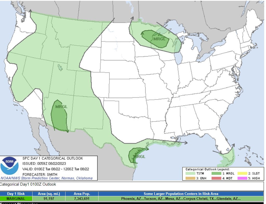
The SPC is great, and I don’t know how easily performed this would be, but I would like to be able to see the population centers by severe region somehow on this map. How do you know that Duluth or Rhinelander are included in the northern marginal risk, because it is hogged by Phoenix suburbs, Tucson and Gulf Coast towns?
The quibble is minor, but I’ve learned that the grasp of geography is not what it should be.
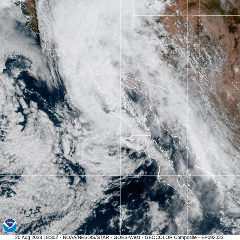
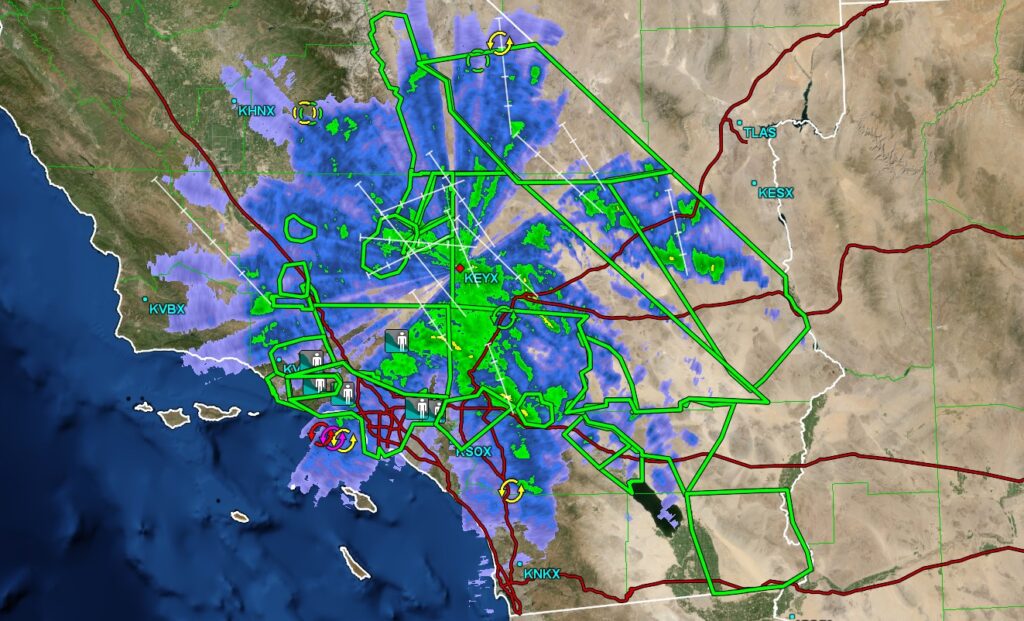
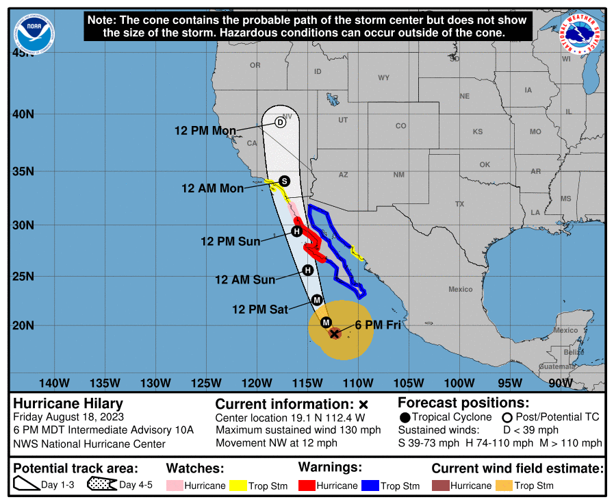
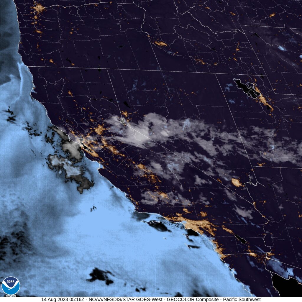
Hilary made landfall earlier today and is now spinning over southern California. There is a lot that makes this different than a tropical storm you would find in the Atlantic, landfalling on that side of the ocean. First is the fact that there is cold water off the Pacific Coast, and the storm eroded quickly before she hit the Baja. Second, there is a lot more terrain in this part of the world than there is in, say, Florida. This means poorer radar availability through the mountains but a more acute threat for flash flooding. Look at all those flood reports and green boxed flash flood warnings if you want proof.
We don’t have the threat for tornadoes like we would to the east, though, and the winds are lower, and there is no storm surge to note. Earthquakes, though…
1200AM update:
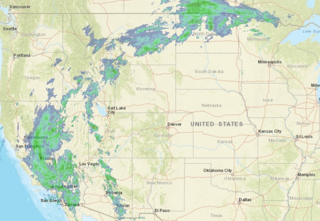
Hilary is pushing moisture all the way up to Sacramento, and then it is catching the upper level flow, and there is a connection that wraps to northern Minnesota.
When we put together our forecast for Syracuse a couple weeks back, I noted that I wasn’t buying into severe weather in the Syracuse area for the 7th and 8th. Truly, the severe weather did avoid Syracuse proper, though it was dicey in the Finger Lakes. Any good emergency response personnel will also tell you that flash flooding is severe weather too, and Syracuse got over three inches of rain during the two games of the forecast period, surely enough to cause significant problems around town. The Weather Channel was substantially better than the rest of this forecast, thanks in large part to a warm forecast on the 7th. Actuals: August 7th, 2.46″ of rain, High 87, Low 66 August 8th, .8″ of rain, High 71, Low 66
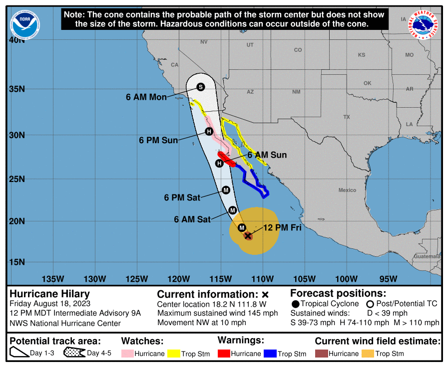
The North Atlantic is finally getting a bit more active, with a few waves that the NHC is monitoring, but right now, the storm that looks the most likely to have the next impact on the US is Hilary, in the eastern Pacific. Hilary at present is a major hurricane, but as she moves north, note that she will start diminishing fairly swiftly. The Pacific is a colder ocean, and her course along the Baja Coast will further blunt the storms intensity. Nevertheless, flash flooding and a few isolated tornadoes are probably going to come for SoCal and western Arizona as next week begins.
8:10 PM Update – The latest projection for Hilary takes her a little bit further to the west, which is bad news for the Southwest. Less time along the coast means that she won’t lose intensity quite as quickly, and there may be a bit more rain, a bit more wind as she moves into the Desert.
130AM Update – Those TS Watches in SoCal are the first to ever be issued for the region.
10pm Saturday Update – Hilary has been downgraded to a Category 1, and will be a tropical storm fairly soon. Like we talk about fairly often with severe weather in the east, this storm will be even more catastrophic because it is coming to a well populated area unaccustomed to tropical weather. The torrential rains will not be well handled, and residents should be prepared to contend with flash flooding.
The Twin Cities have been very fortunate in that they have avoided severe weather for the bulk of the year. Today, much of eastern Minnesota finds itself (along with Western Wisconsin) in the slight risk area for severe storms. It’s been there for 5 days now. Now, however, the short range models have thunderstorms emerging in northern Minnesota and not popping up south of St. Cloud until after 9, when the boundary is almost out of the Twin Cities.
It’s far too early to make any proclamations, but if the short range models are correct, the Twin Cities will continue their dry, incident free summer tonight.
If you have a moment, Rolling Stone has an article with ways to help residents affected by the devastating Maui wildfires. Our hearts go out to those dealing with so much loss.
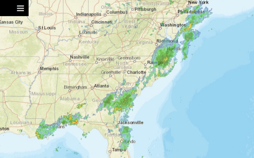
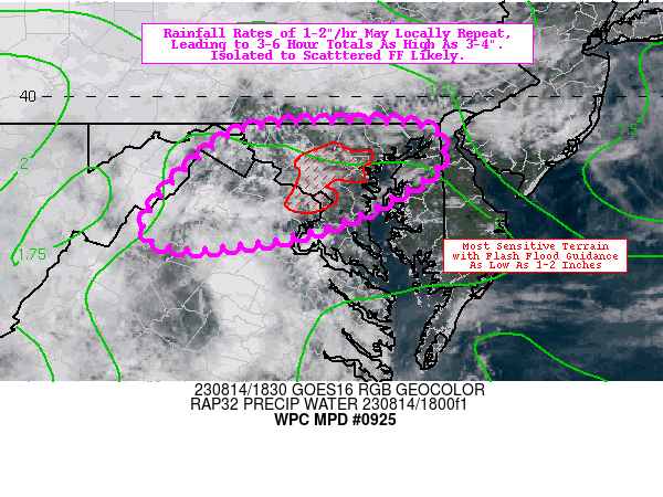
There is a stretch of of the US, generally from the Chesapeake southeast through the central Appalachians, which remains under a slight risk for today. That area will shift only a bit to the southeast tomorrow, and will bring some steady rain along the way. Already, parts of Maryland are being monitored for flash flooding.
The mid-Atlantic has seen a little bit of rough weather of late, and it’s mounting. Heavy downpours are a bit more apt to cause flooding, and that appears to be the situation tonight.
We’re going to head to northern California for our forecast tonight. There hasn’t been as in the news this summer out of California, which is pretty great, but the Yuba City area has been on my mind lately. With the now record breaking wildfires that devastated Lahaina, Hawai’i, I compare the devastation to Paradise, California, which seemed so dreadful at the time. It certainly was, but to think the devastation on Maui is worse boggles the mind.
At 953PM, ET, Yuba City was reporting clear skies with a temperature of 84 degrees. High pressure was in charge, with a few clouds seen over the high Sierras, remnants of afternoon convection. Heat advisories are in place for much of the region. Don’t expect substantial changes with high pressure remaining in place. Hopefully the diurnal convection in the high Sierras feels left out and give Yuba City a bit of shade. Otherwise, there might be an isolated storm in rest of the Valley, but I suspect clouds will be the main impact. Tomorrow – Hot with partly cloudy skies. High 100, Low 73 Tuesday – Fewer clouds, so warmer temperatures, High 106, Low 73
TWC: Tomorrow – Cloudy. High 98, Low 72 Tuesday – Plentiful sunshine. Hot. High 106, Low 70
AW: Tomorrow – Warm with partial sunshine; extreme heat can be dangerous for outdoor activitie High 99, Low 69 Tuesday – Partly sunny and hot; danger of dehydration and heatstroke if outside for extended periods of time High 107, Low 67
NWS: Tomorrow – Mostly sunny and hot, High 99, Low 72 Tuesday – Sunny and hot, High 104, Low 73
WB: Tomorrow – Mostly sunny in the morning then becoming partly cloudy, High 97, Low 71 Tuesday – Sunny, High 105, Low 69
WN: Tomorrow – Partly cloudy, High 99, Low 72 Tuesday – Partly cloudy, High 104, Low 73
CLI: Tomorrow – Mostly cloudy, High 99, Low 70 Tuesday – Sunny, High 105, Low 69
Not a lot on satellite tonight, but it is night that the plumes on satellite are clouds this summer, and not smoke.
One method of forecasting that we have is called “persistence forecasting” which basically using the weather that is seen on one day, and carrying that forward in your forecast. It can work in Florida, especially with what we have see in places like Orlando late in the summer. It’s hot and humid, temperatures generally float at about the same levels, there is usually a stray storm in the area, and you hope to avoid tropical intrigue. That’s how it went for our forecast towards the beginning of the month, though it was a hair cooler than it was when we created the forecast on the 3rd. Accuweather came through with their best performance in a while, and earned victory for the day. Actuals: August 4th, .27 inches of rain in thunderstorms, High 92, Low 76 August 5th, .03 inches of rain in thunderstorms, High 95, Low 79