Reno, like many location in the western US, had a rough go of things over Christmas. On Christmas Eve, in addition to some light snow mixing in, Reno saw 1.28″ of rain, and another .28″ of rain on Christmas Day, which accounts for about 20% of the expected ANNUAL rainfall in Reno. Temperature rebounded on Christmas to ensure all precipitation came as rain, but it was definitely a good day to spend indoors. Clime, which has absolutely no holiday spirit, successfully envisioned this forecast, and got the daily win. Actuals: Wednesday – 1.28″ of rain and snow, High 53, Low 32 Thursday – .28″ of rain, High 50, Low 37
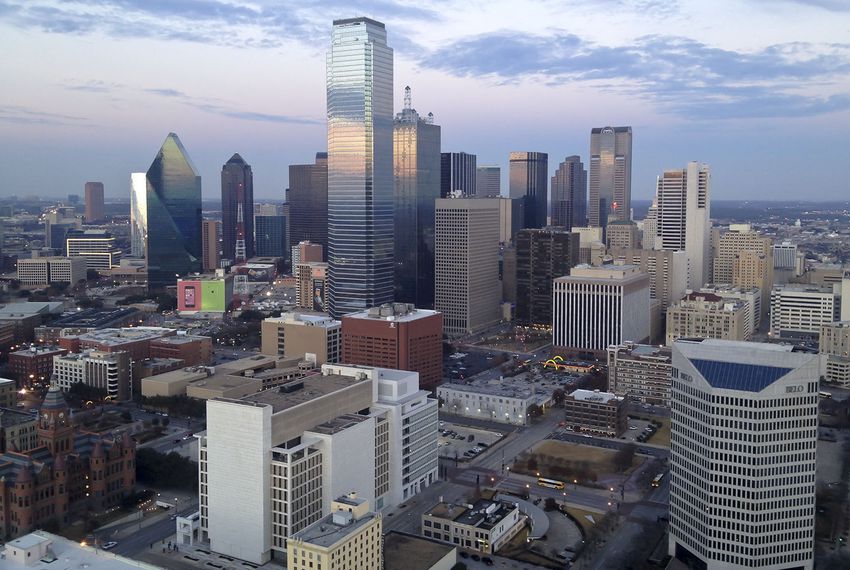
This trip might not seem that long, but it’s actually going to last for parts of two years. The trip actually covers 1213 miles, and will last for two days, with one being a couple hours longer than the other. We will move at a pace of 66.1mph, which means we will be spending New Year’s Eve about 529 miles from Dallas.
DAY ONE (Wednesday)
The real show right now is the copious lake effect event happening closer to our destination in Bay City. More precipitation is moving into the Southwest as well, but that won’t be hurdling the Rockies. Instead, we can expect high pressure and mostly sunny skies from Texas through Oklahoma and into Missouri, where we will reach Cuba for the Countdown.
DAY TWO (Sunday) The disturbance in the Great Lakes is winding down. The parent feature is shifting off into the North Atlantic and becoming a problem for Baffin Island. I’m not fully convinced there won’t be snow in Lower Michigan on New Year’s Day, as wind still looks to be predominantly from the west. That said, our route is really going to be in range for the snow between about Michigan City, Indiana and Paw Paw, Michigan. That’s maybe an hour? And even then, only if the snow slows down traffic. Bay City should be living the good life in the eastern part of the state. Happy New Year!
Generally, when we have mentioned Omega blocks in the past, we have referenced them as the cause of heat waves and exasperating wind and fires in the southwest during the summer months. This winter has offered it’s own blocking pattern, and while it has been unusually warm over the Christmas Holiday, it has also brought about quite a bit of something else.
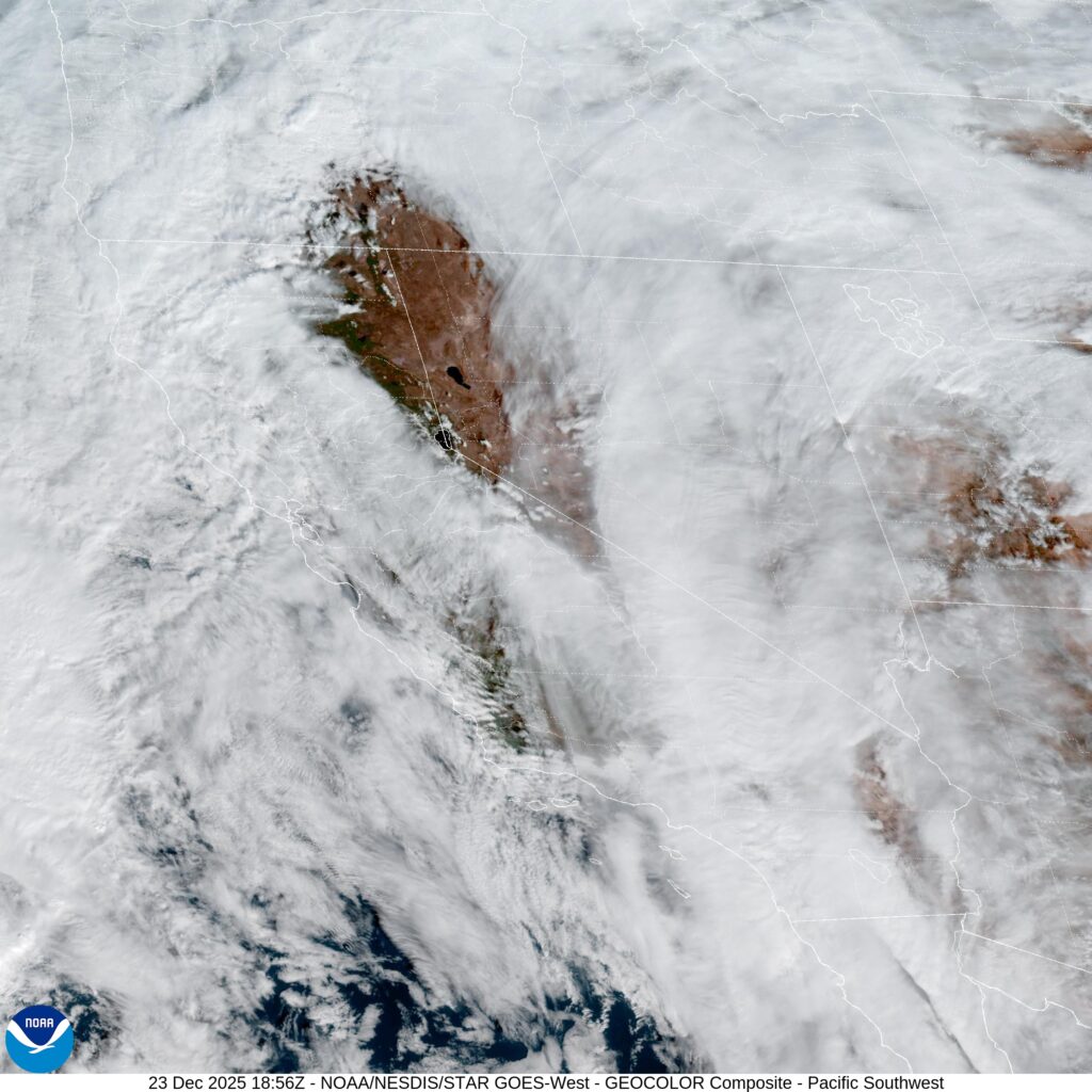
Precipitation. While the ridge in the middle of this block, like a Ω shape, the Greek letter Omega, gets a lot of attention, the winter has been all about the troughs on the west and east of the main feature. We discussed the rain that hammered Redding in our recent verification, but rain and snow has smothered California, with flooding and deadly consequences from San Francisco to San Diego. All of this was after the deadly flash flooding up around Redding.
The rain was heavy, certainly, but what really brought about the problems was the persistence of the pattern. The blocking ridge in the center of the country ensured that the seasonally omnipresent low in the Gulf of Alaska was able to funnel moisture to a low off the California coast, which made for a much wetter stretch than even California’s rainy season is accustomed to.
It isn’t all bad, of course. Anyone in tune with the economics of California knows that the snow in the Sierras is often the only moisture that the Valley will get through the summer months, supplying crops and thirsty residents. A large snowpack, while terribly inconvenient right now, will be a boon for regional agriculture this summer.
On the other coast, the trough has been a good environment for the development of low pressure in the Gulf Stream. This has enhanced some clippers moving out of the Canadian Prairies, as well as more localized development, both features contributed to the travel hassles along the coast over Christmas. The continued winter storm warnings for Lake effect snow in the Great Lakes are all ongoing because of a feature that has rotated and become embedded over Hudson Bay.
For the foreseeable future, this is the outlook. The Plains and particularly the Front Range will remain quite warm. As with most Omega features, even ones in the winter, the West Coast will remain above normal as well, given flow moving down from the mountains when the low pressure off the coast ebbs. Throughout all of it, look for above normal moisture nearly nationwide to start the new year.
Precipitation in California has exceeded all expectations. This is the time of year that the state gets most of its rain, and usually, they can expect a couple of good soakers and impressive snow totals in the Sierras when it happens. The rain doesn’t often fall as intensely in the Central Valley, in addition to the western facing hill sides, as it has this month. Redding, which is at the far northern end of the central California valley system, and called the “sunniest city in California”, was forecast to get some showers during our forecast on the 16th and 17th of December. Instead, it was the beginning of a grueling weeklong stretch of flash flooding and disaster just before Christmas. For our forecast period, Redding saw over an inch and a half of rain, which is quite a bit for anywhere, and certainly a lot for Redding, which has now received twice their monthly expected total for December, already one of the wettest months of the year in northern California. The forecast was fairly well handled on the temperature side, but the quantity of rain was surely underestimated. The Weather Channel had the top forecast. Actuals: December 16th, .96″ of rain, High 48, Low 44 December 17th, .72″ of rain, High 52, Low 43
We’re heading west over the Christmas break. On the plus side, we have work off for the next several days, so we don’t have to worry about that. On the negative end, the drive is over the holidays, which means everyone has time off. Good luck finding help at the convenience store if you need it. The drive will last a little more than 3 1/2 days, covering 1,948 miles at a pace of 67mph. That means the three long days of driving will cover 537 miles. I’m excited to see where we end up on Christmas!
DAY ONE (Wednesday )
Monroe, Louisiana
The Gulf is definitely open, at least on the western side. Fortunately, there isn’t a lot to trigger this instability for Christmas Eve. There may be some lingering clouds throughout the day, and we aren’t going to find a firm dry line, so it’s hard to say when the clouds will end, but they should eventually. We will stop for the day in Newlin, in west Texas. Santa, come to Newlin!
DAY TWO (Thursday/Christmas) It will be a bright and beautiful morning on Christmas as we arise in Newlin. Will we receive gifts? That depends on your Naughty or Nice list status, but we should treasure the good weather we will see for the remainder of the Texas Panhandle and throughout New Mexico. Clouds my begin to pop up as we hit some terrain west of Albuqueque, but precipitation will remain closer to the Four Corners. Our drive will pass into Arizona on Christmas day, but only just. We’ll spend the night in Lupton, preparing for a much rougher day on Friday.
DAY THREE (Friday) I know it sounds crazy to say, but in the higher terrain near Flagstaff, don’t be surprised to see some snow. It should stay away from the interstate, and I suspect the drive in Arizona, at least, will remain dry. We will take US-95 from Kingman, which means we will cross by the Hoover Dam before we reach Las Vegas. Unfortunately, the Vegas portion of the matter may also feature some isolated showers. It will be an improvement for Sin City, which may see some thunderstorms and heavy rain on Christmas Day, so be careful if the city is recovering from the unusual weather. We will continue northwest to Beatty, which will also be unusually damp.
DAY FOUR (Saturday) The center of low pressure, the main one at the base of the trough will move ashore on Boxing Day and have a tough time maintaining itself when it arrives inland. It’s going to completely dissipate at the surface by Saturday. This means that whatever rain fell over the Holiday week on 95 will be dried and gone for the conclusion of our trip through Nevada. The only problem will be finding a place to stop to use the restroom!
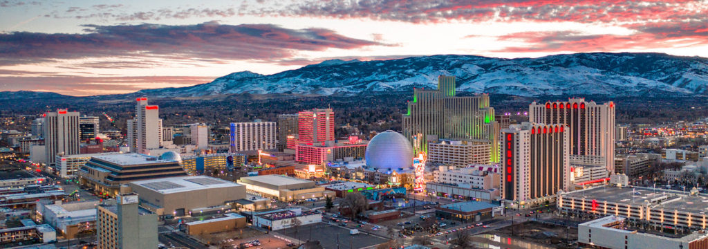
Happy Holidays, everyone! This forecast for Reno will take us across Christmases Eve and Day. Christmas in Reno, sounds like it should be airing on Hallmark Channel.
At 1055AM, PT, Reno was reporting a temperature of 57 degrees with clear skies and a brisk south wind. This is in response to a strong trough along the West Coast. A center of circulation lies off the California shore, with southerly flow rushing through the Golden State. The Sierras are beset by heavy snow, and are also keeping Reno clear for now. Most of the region is covered by clouds, however there is a donut hole over western Nevada. The low itself will be moving northeast before arriving on the coast on the Oregon coast. The robustness of this feature and the paired advance of the jet structure will allow for a fully realized cold front to be dragged along with it. Expect some substantial rainfall, particularly for Reno, on Christmas Eve. The surface feature and leading edge of the jet will continue east of the region by Christmas. The base of the trough will still foster cyclonicity in the Pacific, which will mean more southerly flow in the west. While Reno will see less precipitation for Christmas, the Sierras will not, and travel into California from Reno will remain treacherous. Tomorrow – Rain likely, High 43, Low 37 Christmas – Partly cloudy, with some passing showers, High 37, Low 31
TWC: Tomorrow – Cloudy. Periods of rain early High 46, low 39 Christmas – Rain showers, with winds diminishing later in the day. High 44, Low 38
AW: Tomorrow – Mostly cloudy and cooler with a bit of rain; breezy in the afternoon Hgh 46, Low 39 Christmas – Mostly cloudy, becoming windier and chilly with a couple of showers High 44, Low 36
NWS: Tomorrow – Rain. Snow level 6700 feet lowering to 6100 feet High 50, Low 40 Christmas – Rain. Snow level 5700 feet High 46, Low 35
WB: Tomorrow – Rain and snow. Snow level lowering to 6500 feet. Snow accumulation of 1 to 3 inches. High 46, Low 39 Christmas – Snow and rain. Snow level 5500 to 6000 feet. High 43, Low 39
WN: Tomorrow – Cloudy with rain, High 49, Low 39 Christmas – Cloudy with rain, High 46, Low 35
CLI: Tomorrow – Rain showers High 51, Low 41 Christmas – Rain showers High 47, Low 39
Nevadans aren’t often beset with soggy days, so getting it on Christmas is particularly bad luck. they have a pretty nice window of sunshine right now, however!
The headlines have all switched as we look ahead to Christmas. A lot of the country is going to see temperatures that are much warmer than normal, which is an about face after a particularly brisk beginning to the month. Our forecast in Hot Springs called for temperatures that were below freezing on Sunday and Monday morning. Fortunately, with the clear skies in the afternoon, temperatures were able to bounce back, and highs were warmer than the forecasts called for, even if they weren’t “warm” per se. Clime came away with the top forecast. Actuals: Last Sunday, High 42, Low 22 Last Monday, High 47, Low 20
I think we have all been here long enough to see what outlets we expect to rate near the top of the heap in most months, and which are going to be a bit further down in the pecking order. The Weather Channel, the Weather Service and Accuweather (along with Victoria-Weather sometimes) are typically near the top, so it is a real underdog story when another outlet grabs the title. This is one of those months. Weatherbug was the top forecaster of the month, despite having had the toughest go of it for the first 10 months of the year.
It was a chilly weekend last weekend, particularly Sunday, in north Texas. We had a forecast for Sherman, and we knew that it was going to cool down, but clearly, we weren’t fully appreciative of how cold it was going to get. Accuweather had the top forecast for the weekend, and even they were 10 degrees too warm on the Sunday high of 37. Fortunately for them, that was the one really big issue they had, successfully navigating the rest of the forecast. Actuals: Saturday – High 66, Low 35 Sunday – High 37, Low 26
Let’s head west! Our drive is a little bit longer than the previous one, with this one coverinf three time zones, 4 days and 2,088 miles. We will be able to enjoy the luxuries of highway travel throughout much of the journey, which will afford a pace of 65.25mph, and 522 miles a day. Will we finally see some warm weather?
DAY ONE (Thursday)
Hot Springs, Arkansas
With high pressure beginning to drift out of hte central US, the cold air is alleviating. This, unfrotunately, also means that access to the Gulf is opening again, and some surface moisture is expected to get into the western parts of Arkansas, particularly the valleys, in the morning. This may manifest as a bit of light rain between Hot Springs and the Oklahoma border, but more likely, it will be seen as fog and low clouds. Low pressure is emerging in the northern Plains by tomorrow, and a cold front is going to emerge along our route. No concerns for developing showers or storms, but behind it, there will be a brisk northwest wind. Clear skies are expected after Henryetta, and winds should start to taper off around El Reno. The day will end in Groom, Texas, which is just east of Amarillo.
DAY TWO (Friday) Another wave is going to ripple through the Rockies into the High Plains. What will this mean for us? Not much, save for more blustery winds between Amarillo and Santa Rosa, New Mexico. We will enjoy a bit more tranquil conditions though the high terrain of western New Mexico, and make it to the Painted Desert National Park in Arizona.
DAY THREE (Saturday) The weather is really going ot be churning in the northwestern US, however there isn’t a whole lot to tlk about in the southwest. It won’t be hot in the desert, as we may be accustomed to thinking, which is good news, because our day will end at Edwards Air Force Base.
DAY FOUR (Sunday) It’s probably the best to take highway 99 north through California on a Sunday, right? Or is most of the traffic hanging out on 5? Or does anyone even drive in the Central Valley? Nevertheless, we will be doing it on Sunday, as another system moves into the Pacific Northwest. In the Valley, we will see a smattering of light rain, while the hills and mountains east of us will contend with some significant snow fall, once again. The rain for us will come into the picture around Kingsburg, and in points northward. Sad to say, it may be a bit drizzly in northern California by the time we arrive in Redding on Sunday afternoon.