Raleigh, North Carolina

Holiday travel is at its peak this week, and especially tomorrow. We are taking to North Carolina for our forecast for this busy day.

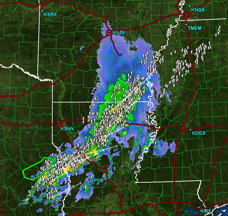
At 1051PM, ET, Raleigh was reporting cloudy skies with a temperature of 36 degrees. The clouds may save the area from an especially chilly night, and they are patchy, with most reporting areas in the region reporting clear skies. An occluded front in the Plains attaches to a secondary low over eastern Tennessee. Temperatures in Georgia and South Carolina are about 20 degrees warmer than they are in North Carolina, indicating the warm front. This is in active, however the cold and occluded fronts are well defined on radar, from the Upper Ohio Valley to northern Alabama and on to east Texas, where there is some convective activity.
The parent low is moving northeastward, and the secondary low doesn’t have a lot of vorticity support to carry on, and the southern cold frontal portion of the boundary will wither, even as a cold surface high pressure center slides from the Great Lakes to the Carolinas. Expect a chilly night Sunday after a few showers in the evening. Aloft, the pattern features a sharp trough moving out of the Rockies into the Plains. The ridge sweeping into the Carolinas overnight Sunday to Monday will kick out quickly. Rain is returning with more fervor on Tuesday, but for our purposes, that should only mean increasing clouds on Monday night.
Tomorrow – Mostly cloudy, with a shot of rain in the afternoon. High 53, Low 29
Monday – Sunny, with clouds increasing after sundown, High 49, Low 31

TWC – Tomorrow – Cloudy with occasional light rain in the afternoon. High 55, Low 30
Monday – Intervals of clouds and sunshine. High 49, Low 35

AW: Tomorrow – Cloudy with a couple of showers in the afternoon High 56. Low 33
Monday – Cloudy in the morning, then times of clouds and sun in the afternoon High 51, Low 36

NWS: Tomorrow – A chance of rain, mainly between 2pm and 4pm. Mostly cloudy, High 54, Low 30
Monday – Mostly sunny (early rain) High 50, Low 35

WB: Tomorrow – Mostly cloudy. A slight chance of rain in the morning then a chance of rain in the afternoon High 54, Low 33
Monday – Mostly sunny.  High 47, Low 38

WN: Tomorrow – Mostly cloudy with chance of light wintry mix, High 54, Low 32
Monday – Mostly sunny, High 50, Low 34

CLI: Tomorrow – Rain showers, High 58, Low 30
Monday – Sunny, High 49, Low 33

It’s a busy stretch, especially in the Carolinas. You can keep an eye on things in Raleigh on WRAL’s live radar stream.

Birmingham’s Not-So-Stormy Weekend

Ahead of the Thanksgiving travel season, a storm system passed through the American southeast before petering out in the mid-Atlantic. There were some outlets that thought that it could lead to a bit of a severe weather outbreak around our forecast destination of Birmingham last Friday and Saturday, but fortunately, that didn’t come to pass. The whole feature was a bit messier than it could have been, and left some light showers in the region on Saturday as well as Friday, and didn’t bring the cold pool behind it that was in the forecast for some. It hit 80 last Saturday! Clime came away with the top forecast, thanks to a being one of the warmer forecasts on Saturday.
Actuals: Friday . 06″ of rain, High 71, Low 57
Saturday .03″ of rain, High 80, Low 55

Grade: A-C

Updates 11/26

4:26PM: Thanksgiving is tomorrow! I hope you aren’t just learning that from me. The country mostly looks like it will in Springfield, Missouri. Mostly clear, and with the first dose of chilly air for the season. It will continue snowing in the Great Lakes, and be warm out west, but it’s a big country and this is only one blog. Happy Thanksgiving!

9:48PM It has been a very windy at Victoria-Weather headquarters today behind the system bringing snow to the Great Lakes and rain in New England, but the post-frontal howling wind is nothing compared to what they are looking for in the Upper Ohio Valley.

Providence, Rhode Island

Tonight’s forecast will take us to New England through the Thanksgiving holiday. How will Rhode Islanders enjoy the day?

At 451PM, ET, Providence was reporting a temperature of 50 degrees with overcast skies. Rain was approaching, already sneaking into the southwestern corner of Rhode Island, at the leading edge of a warm front. The system is deeply occluded, and the cold front will pass through overnight as well. Southerly flow will follow the secondary cold front on Wednesday, which may drag a bit of moisture into the region, leading to a cloudy, at times drizzly day before Thanksgiving.
There is one last wave of moisture expected to slide through New England on Thanksgiving, but it is unlikely that there will be lingering effects. The day will be increasingly sunny, and quite pleasant by dinner time. Happy Thanksgiving!
Tomorrow – Rain, particularly early, with lingering showers throughout, High 59, Low 48
Thanksgiving – Some drizzle early then clearing and colder, High 55, Low 33

TWC: Tomorrow – Chance of a morning shower. Overcast. High 59, Low 48
Thanksgiving – Sunny along with a few clouds. High 55, Low 36

AW: Tomorrow – Rather cloudy with a couple of showers; wet weather can make for slow holiday travel High 61, Low 48
Thanksgiving – Sunny to partly cloudy, windy and cooler High 55, Low 34

NWS: Tomorrow – A slight chance of rain between 9am and 3pm. Patchy fog.  High 61, Low 47
Thanksgiving – Mostly sunny, (AM Rain) High 56, Low 36

WB: Tomorrow – Cloudy with a 20 percent chance of rain. Patchy fog High 59, Lo 50
Thanksgiving – Sunny High 55, Low 36

WN: Tomorrow – Mostly cloudy with isolated showers, High 61, Low 47
Thanksgiving – Mostly sunny (early showers), High 54, Low 35

CLI: Tomorrow – Overcast High 60, Low 50
Thanksgiving – Partly cloudy, High 56, Low 35

Rain will be light, regardless of what happens, for a lot of the forecast period. And temperatures will be on their way down, so the Turkey Day Touch Football game looks to be a good way to warm up. Radar showing rain moving in is below, and if you are looking to get really involved, here is a live camera from Providence.

Updates 11/25

2:52PM: There is a tornado watch out in Alabama right now. SPC has issued the below Mesoscale Discussion. Things are just starting to erupt in the region, but the severe weather is already past Tuscaloosa and nearly out of Birmingham. The area to keep a keen eye on for the next few hours is from Selma to Montgomery.

Updates 11/24

10:32PM: We focused on snow that will come this week, and there will be some disruptive shower activity through the middle of the week. I didn’t do a good enough job of conveying the possibility of thunderstorms. Look at all this lightning in Mississippi and Louisiana! Fortunately, only a flash flood warning for severe alerts right now.

Some snow for Thanksgiving

We are arriving in one of the busiest travel seasons of the year, as millions of Americans will travel over the river and through the woods to Grandmother’s house. The great news is that most of the winter weather that is forthcoming is steering clear of the major airports. A shortwave will be pulling out of the southern Plains and headed for the mid-Atlantic by Tuesday afternoon but this will bring primarily rain and maybe a low cloud deck, both problems for flight operations.

But rain and clouds aren’t a disaster, as the clouds and visibility won’t be as low as they would be with a snowstorm. Any weather delays are likely just going to be secondary to the volume and other issues that arrive at airports. It will be slow in some important areas because of the rain, but not a disaster by any stretch of the imagination. I’m talking about New York, Philadelphia and Washington, reaching parts of coastal New England on Wednesday. By Thanksgiving, it will be clear and crisp up and down the Eastern Seaboard.

Fortunately, the threat for snow isn’t going to be a problem for most of the country, especially air travelers. Unless, of course, you are going to northern Minnesota. The occluded portion of the feature that will be responsible for the rain out east is also responsible for winter weather alerts from Montana to the UP of Michigan. The heaviest stripe of snow will be in Northern Minnesota, and should be wrapped up by midday on Wednesdsay.

This isn’t a ton of snow, and the roads that it impacts aren’t well travelled. There won’t be volume issues in Bismarck or Duluth or Rhinelander, some airports that will see some of this snow. Lake effect snow will become a problem on Thanksgiving, so Cleveland and Buffalo are going to be tricky for day-of traveling, and perhaps returning home on Friday as well.

Birmingham, Alabama

Between the early start to tornado season and the exposure to hurricane season, Alabama is one of the more interesting places to forecast the weather. Undoubtedly, this is why James Spann, one of the more famous TV weatherpeople has built such a respected reputation, working in Birmingham. Perhaps we have an interesting forecast in our future?

At 1053PM, CT, Birmingham was reporting a temperature of 61 degrees with overcast skies. There was weak ridging in the area tonight, helping to provide some stability, however a weakening disturbance over the Southern Plains is advancing to the east, and the attendant warm front runs through Tennessee. The rest of the energy will arrive in the late morning tomorrow, with light rain and an isolated rumble of thunder.
The back end of the energy lies well west of the precipitation that will begin tomorrow morning. Expect the coverage and intensity to pick up late tomorrow evening into Saturday morning. The tailing cold front will stall across central Alabama, leading to an ongoing threat of light rain to start the weekend. Fortunately, there is an area of surface high pressure behind the wave moving in overnight tonight, and the latter half of the weekend will be clearer.
Tomorrow – Scattered showers and isolated thunderstorms, High 72, Low 58
Saturday – Mostly cloudy with a smattering of light rain, High 75, Low 57

TWC: Tomorrow – Rain showers in the morning with thunderstorms developing in the afternoon. High 70, Low 58
Saturday – Showers in the morning, then partly cloudy in the afternoon. Thunder possible. High 77, Low 58

AW: Tomorrow – Rather cloudy with a heavy thunderstorm in the afternoon; thunderstorms can bring hail and damaging winds High 72, Low 60
Saturday – Mostly cloudy and warm High 75, Low 53

NWS: Tomorrow – Showers likely, with thunderstorms also possible after 3pm. Mostly cloudy, High 72, Low 59
Saturday – A 20 percent chance of showers and thunderstorms before noon. Cloudy through mid morning, then gradual clearing, High 72, Low 58

WB: Tomorrow – Mostly cloudy. A chance of showers in the morning then showers likely with a chance of thunderstorms in the afternoon. High 70, Low 63
Saturday – Mostly cloudy with a slight chance of showers and thunderstorms in the morning then sunny in the afternoon. High 74, Low 60

WN: Tomorrow – Mostly cloudy with light showers and a chance of storms, High 72, Low 59
Saturday – Partly cloudy with isolated storms, High 76, Low 60

CLI: Tomorrow – Thunderstorm, High 72, Low 58
Saturday – Light rain showers, High 77, Low 55

I think the response to the boundaries and clouds associated with this fairly quick moving system could really play havoc with this forecast. I should note that the low temperatures on Saturday are expected to occur at midnight leading to Sunday. The radar is showing off some showers, but few are reaching the ground….. yet.