
10:08PM: It’s getting cooler out there, absolutely, and even amid hot spells, there is one sure way to know that the atmosphere is chilling out. Cloud bases are getting lower. I had to keep looking at the radar to ensure it wasn’t about to rain today because of the lower deck of cumulus clouds.
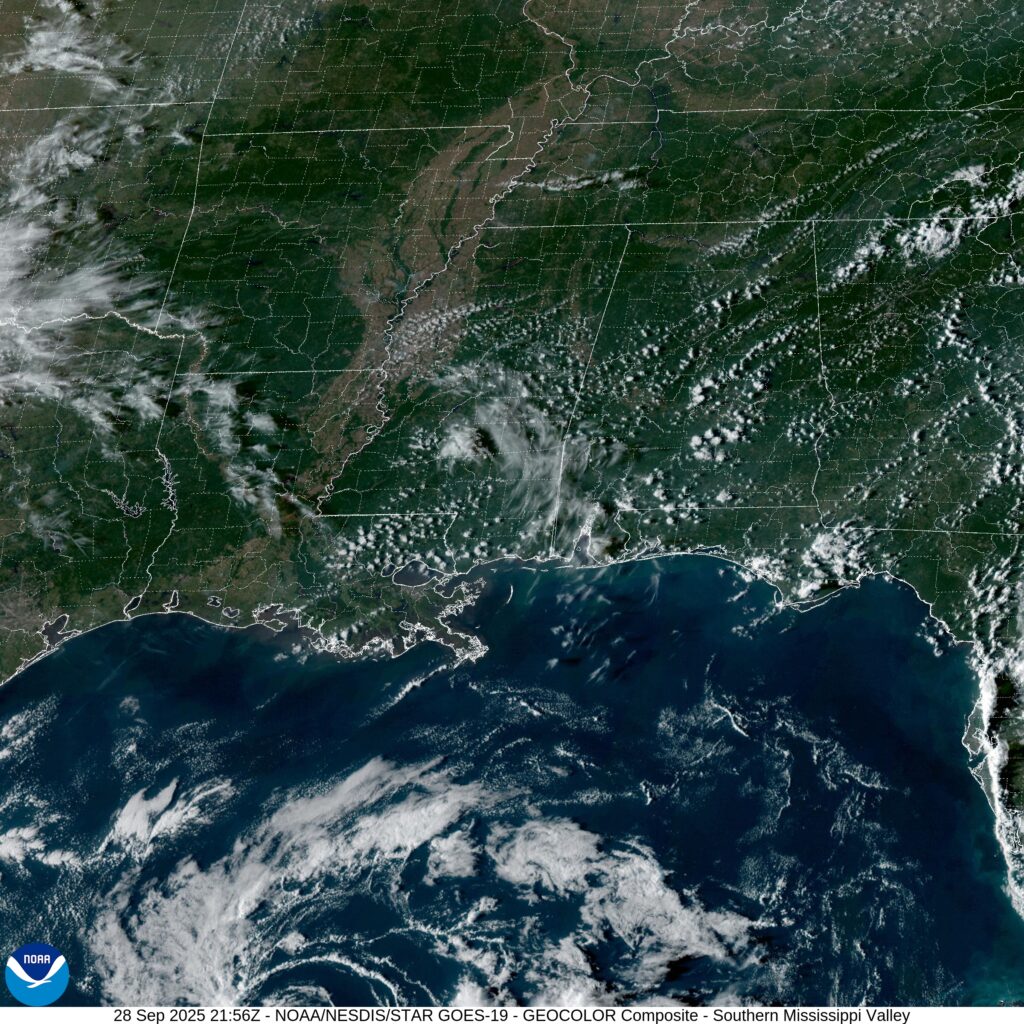
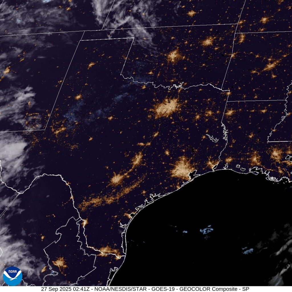
Gulfport, Mississippi
Unlike Davenport, Gulfport IS a port, and that is how it got its name.
At 453PM, Central Time, Gulfport was reporting clear skies and a temperature of 88 degrees. With multiple tropical features in the western Atlantic, the tropical energy was redirected away from the Gulf, and the Gulf Coast was in the midst of a nice, clear stretch of autumn weather.
With nothing driving traffic in the immediate region, eyes turn to Humberto and Imelda, which are going to dance together before merging through the middle of the week. As the pair of storms move off to the Atlantic, a bit of a sea breeze will return, with some afternoon storms coming back on Tuesday.
Tomorrow – Mostly sunny, High 91, Low 69
Tuesday – Mostly sunny, isolated storms late, High 90, Low 69
TWC: Tomorrow – A mainly sunny sky. High 90, Low 71
Tuesday- Sunshine and some clouds. High 90, Lo 70
AW: Tomorrow – Warm with plenty of sunshine High 91. Low 70
Tuesday – Mostly sunny and remaining warm High 91, Low 70
NWS: Tomorrow – Sunny, High 88, Low 71
Tuesday – Sunny, High 88, Low 71
WB: Tomorrow – Sunny. High 86, Low 72
Tuesday – Sunny. High 88, Low 71
WN: Tomorrow – Mostly sunny, High 88, Low 71
Tuesday – Mostly sunny, High 88, Low 71
CLI: Tomorrow – Sunny, High 91, Low 71
Tuesday – Sunny, High 89, Low 70
It’s not often that I am on the island with precipitation in the forecast. Also, The Weather Channel got a little bit of a refresh, which is almost as clean as this satellite image.
Updates 9/28
2:01PM: More good news, especially if you are a fan of the NAM model: It is really showing Imelda taking a hard easterly turn before it reaches the Carolinas. Come on, NAM!
Pueblo, Colorado to Davenport, Iowa
Wow. I’m not sure you could find a longer, flatter stretch of west to east driving in the country. We will see a great deal of prairie over the day and a half drive. We’ll cover 953 miles, which will be traversed over at a pace of 70.1mph, which might be the highest I’ve seen. That means day one will be through after 561 miles, or so.
DAY ONE (Sunday)

There isn’t much to say for the day on Sunday. High pressure in the center of the country will keep things dry in the Plains, and unseasonably warm. There is going to be a bit of zonal flow across the Rockies, producing showers and overcast for the first stretch along the Front Range, but clear skies the rest of the way, where we will stop in Odessa, Nebraska, near Kearney, for the layover.
DAY TWO (Monday)
It’s going to be a warm day for a late September drive, but otherwise uneventful, aside from maybe traffic and construction in Omaha and Des Moines. The directions should be pretty easy too. I-80 to the destination, and there it is.

Updates 9/27
6:46PM Imelda is still unnamed in the central Bahamas. In even better news, the storm is even less likely to make a landfall in the US. It will still be impactful, of course, but less rainy and less windy than feared.
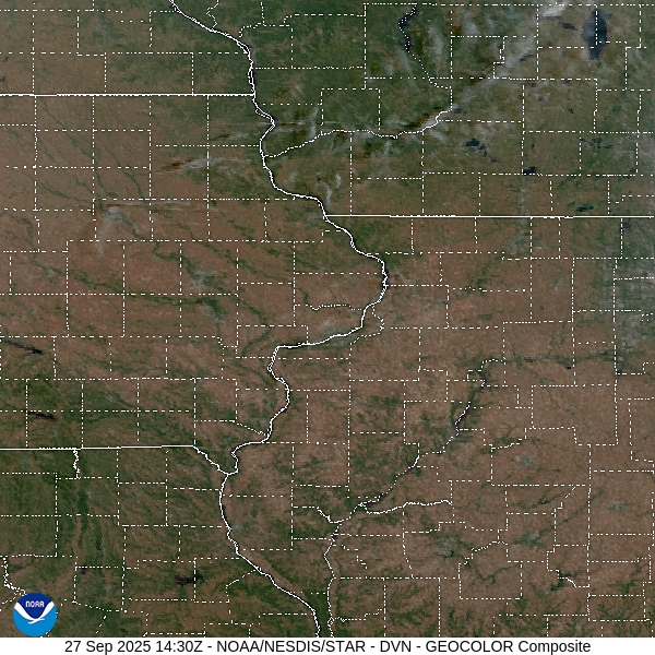
Davenport, Iowa
I had assumed that Davenport was named as such because it is on the Mississippi River, and a port. Nope, just named after a guy named Davenport.
At 1052AM, CT, Davenport was reporting a temperature of 83 degrees with clear skies. It was fairly breezy across the area, especially just above the surface. This is because of the leading edge of lee troughing extending all the way into the Dakotas, and brisk southerlies across the Hawkeye State.
The jet is zonal and well into Canada, indicating a dry, sunny and warm couple of days ahead. The high pressure centered over the Great Lakes is going to help squash the tropical features in the western Atlantic away from the coast and towards the central Atlantic.
Tomorrow – Mostly sunny, High 86, Low 55
Monday – Sunny, High 87, Low 55
TWC – Tomorrow – A mainly sunny sky. High 88, Low 57
Monday – Mainly sunny High 90, Low 57
AW – Tomorrow – Very warm with plenty of sunshine High 87, Low 57
Monday – Very warm with plenty of sunshine High 88, Low 55
NWS – Tomorrow – Sunny, High 87, Low 59
Monday – Sunny, High 88, Low 59
WB – Tomorrow – Sunny, High 88, Low 58
Monday – Sunny, High 88, Low 58
WN: Tomorrow – Sunny, High 87, Low 59
Monday – Sunny, High 88, Low 59
CL: Tomorrow – Sunny, High 87, Low 57
Monday – Sunny, High 88, Low 57
That was a pretty easy forecast. With temperatures potentially reaching the 90s, I would say this qualifies as pretty toasty for late September. Satellite shows a bit of scud, stirred up the brisk winds, but there isn’t much moisture to make for a lot of clouds.
Updates 9/26
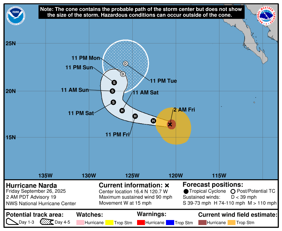
9:11AM. A lot more mental energy is spent on the Atlantic side of the tropics, and for good reason. The Pacific is generally more active, but after storms get going, there is just less out there to impact. Take a look at Hurricane Narda, which will do the typical tropical poleward curl and really only impact some fish. And that’s a fairly typical eastern Pacific lifecycle.
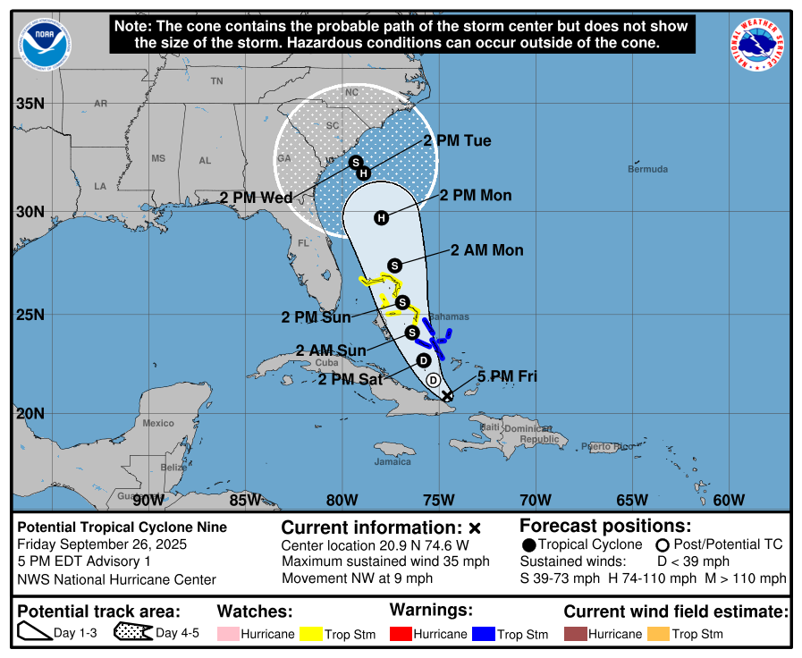
4:34PM. And back to the mainland. TS Nine has now developed near Cuba, as expected. It stands a pretty good chance at this point of landfalling between Charleston and Myrtle Beach as Tropical Storm Imelda, if the track remains approximately the same. The good news is that it will probably not be a hurricane when it does so. It does look to lumber through the region though, and heavy rain is going to be a problem in the Carolinas this weekend.
9:48PM. All clear in Texas tonight.
Updates 9/25
11:11PM Make a wish! With eyes turning to the Bahamas for a little bit of tropical development, we can all feel better about ignoring the local weathermen. This late September pattern is warm, and hasn’t really featured a lot of severe weather. The SPC outlook only has anything greater than general storms as a marginal outlook associated with the monsoon along the Arizona/New Mexico border.
Updates 9/24
4:37: As it was when I wrote about the hurricane season earlier, it is the Atlantic that is active, rather than the Caribbean or the Gulf, and as I noted, the Atlantic itself is plenty hospitable for tropical development. We now have Humberto, and more pressing, an area that stands to sustain more development as it tracks through the Bahamas later this week.
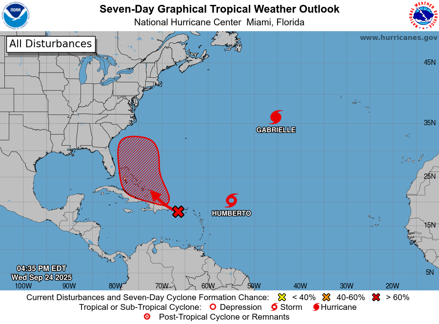
8:36PM Here are the forecast tracks of a still unnamed storm. It will pass over the Dominican Republic overnight tonight, which will certainly slow down any real development. As it get into the Bahamas we are probably then looking at a Tropical Storm (Imelda), which then looks like a Cat 1 hurricane along the Outer Banks. Maybe. Stay tuned.
Updates 9/22/25
11:05PM: The Mid Atlantic track of our tropical season has made for a very dull time in the southeast. Without clouds, temperatures are a degree or two warmer than normal, to go along with dry conditions. Fortunately, perhaps, there is rain coming for parts of north Florida and south Georgia and Alabama on Friday. That might be nice.