The forecast in Monroe seemed promising. There was a little bit of rain in the early part of Wednesday, but then the heat was supposed to break. It certainly did not. Instead, high temperatures remained in the mid 90s, which was just as hot as it was before a weak cold front slid through. The National Weather Service and Weathernation weren’t optimistic about a cool down, and ended up claiming a forecast victory. Actuals: Wednesday – Thunderstorms reported, not measured, High 95, Low 72 Thursday – High 95, Low 70
Today’s forecast brings us to northern Louisiana. The weather here tends to be less ‘coastal’ and seems to be more at the mercy of the factors that drive the weather elsewhere in the southern Plains and lower Mississippi Valley.
At 818AM. CT, Monroe was reporting light rain with a temperature of 77 degrees. A large area of showers and thunderstorms lingered over northeast Texas, and extended a narrow tendril of rain through northern Louisiana. This outflow boundary suggested that the overnight convection was dissipating for the time being, but it seemed unlikely that the storm machine would be out of commission very long. A deep area of low pressure was spinning in western Ontario, draping a long, winterlike cold front through the Plains and into the Red River Valley. The length and orientation of the boundary seemed to indicate that the feature wouldn’t be moving with any urgency. The scattered showers and thunderstorms will be an ongoing threat today into tonight. the front will linger over central Louisiana through the day tomorrow, which might mean some more clouds and spots of rain. The low will shift to the northeast through the period, and this will allow the front to diminish. high pressure will take over for Thursday, and it may be a tick cooler than it’s been lately over the next couple of days. Tomorrow – Mostly cloudy, with isolated showers, High 86, Low 74 Thursday – Mostly sunny, High 91, Low 70
TWC: Tomorrow – Thunderstorms likely in the morning. Then the chance of scattered thunderstorms in the afternoon. High 89, low 74 Thursday – Sunny skies. High 90, Low 69
AW: Tomorrow – Intervals of clouds and sun, a couple of showers and a thunderstorm High 87, Low 74 Thursday – Partly sunny High 91, Low 68
NWS: Tomorrow – A 50 percent chance of showers and thunderstorms. Mostly cloudy High 90, Low 74 Thursday -Sunny, High 92, low 69
WB: Tomorrow – Mostly cloudy with a 50% chance of showers and thunderstorms, High 88, Low 74 Thursday – Mostly sunny, High 89, low 70
WN: Tomorrow – Mostly cloudy with scattered storms, high 90, low 74 Thursday – Mostly sunny, High 92, Low 69
FIO: Tomorrow – Light rain tonight and tomorrow morning. High 86, Low 75 Thursday – Clear throughout the day. High 89, Low 70
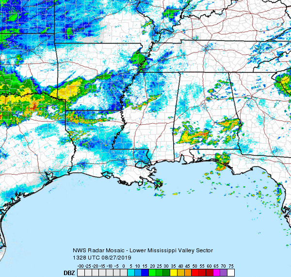
The radar in Jackson is out, so we will take a look at the big picture. That bowl shaped band of showers moving through the northern parishes of Louisiana is caused by storms to the north beginning to collapse.
The forecast later in the week for Monroe, Michigan would become a little bit gloomier, but at the beginning of the week, there was only an isolated shot at some showers. It was warm, otherwise, with a lot of sun. More sun than expected, because those rain showers never materialized in Monroe, and temperatures warmed even more than expected. A warm forecast doesn’t usually mean Weatherbug has a horse in the race, but they did this time, claiming victory. Actuals: Sunday – High 64, Low 43 Monday – High 72, Low 55
It’s a rough time for basketball fans in Michigan. Michigan State lost tonight, while Michigan lost last weekend, and both to the same team, Texas Tech. Perhaps they will cope quickly. Does Monroe have the forecast for recuperation?
At 1253AM, ET, Monroe was reporting a temperature of 46 degrees with clear sites. Dew points were also at 46, and with haze filtering in around Ann Arbor, it seems as though the morning will be hazy in Monroe. Low pressure is developing in the Plains, with a warm front already arcing through northern Michigan. Warm, moist air was spilling into the eastern Great Lakes. Low pressure will reach Michigan by this afternoon, with some rain and isolated thunderstorm activity joining it. The parent trough has been fairly shallow and is expected to move quickly across the northern US. The precipitation will ultimately punch through the region in the afternoon and evening and be out of the picture by Monday morning. It will be cooler to start the work week, but the responsible trough will be shallow enough that cold air won’t be overwhelming. Tomorrow – Rain with a bit of thunder in the afternoon, High 63, Low 46 Monday – Clearing through mid morning, and warmer, High 68, Low 53
TWC: Tomorrow – Cloudy early with showers for the afternoon hours. Thunder possible. High 58, Low 41 Monday – Cloudy early with partial sunshine expected late. High 67, Low 52
AW: Tomorrow – Increasing cloudiness, mild; spotty afternoon showers High 62, Low 45 Monday – Clouds giving way to some sun; warm High 69, Low 54
NWS: Tomorrow – A chance of showers after 2pm. Mostly cloudy, Hgh 65, Low 45 Monday – Mostly sunny, (Early rain) High 68, Low 5
WB: Tomorrow – Mostly cloudy. Slight chance of rain in the morning, then rain showers likely and slight chance of thunderstorms in the afternoon. High 64, Low 43 Monday – Mostly sunny, High 68, low 55
WN: Tomorrow – Mostly cloudy with isolated storms, High 65, Low 44 Monday – Partly cloudy with isolated showers, High 68, Low 50
FIO: Tomorrow – Light rain in the evening. High 60, Low 40 Monday – Mostly cloudy until night. High 64, Low 51
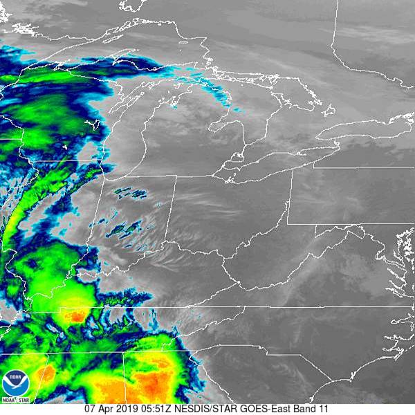
Satellite has some clouds to the southwest. That’s the rain coming later today.
NOAA/NESDIS/STAR GOES ABI BAND 11 OR_ABI-L1b-RadC-M6C11_G16_s20190970551218_e20190970553591_c20190970554048.nc