One could interpret my headline in two different ways. The … representing a gap where one might typically say a “dry” heat, but it wasn’t that in Midland during our forecast period. Nor was it obnoxiously humid, with dew points dipping into the 50s overnight. Or, you could interpret it as a heat, as in a dead heat, because three outlets drew level this time around. The Weather Channel, Weather Service AND WeatherNation ended with the same score. Two forecasts down this month, and two results with a 4 way then a 3 way tie. Actuals: August 14th, High 99, Low 74 August 15th, High 96, Low 78
This drive has all the elements of what I think makes a good road trip. It will take one long day, following only a couple of interstates. There is one major metro area to drive through, but also a long stretch in the open country. It will take nearly 10 hours to cover the 658 miles between our two destinations, covering the ground at a pace of 66.2mph. Hopefully traffic in Dallas-Fort Worth is forgiving.
Pine Bluff, Arkansas
Arkansas is going to be downright juicy on Thursday. Humidity will see dew points in the mid to upper 70s, and while guidance suggests most of the rain and thunder will be from Mississippi eastward, I wouldn’t rule it out during our drive to Texarkana. In fact, I would venture to say that the heavy atmosphere might lend itself to a stray storm as far west as Mount Vernon, Texas. The dew points will relent a bit west of Dallas, but the heat will still be there all the way in to Midland.
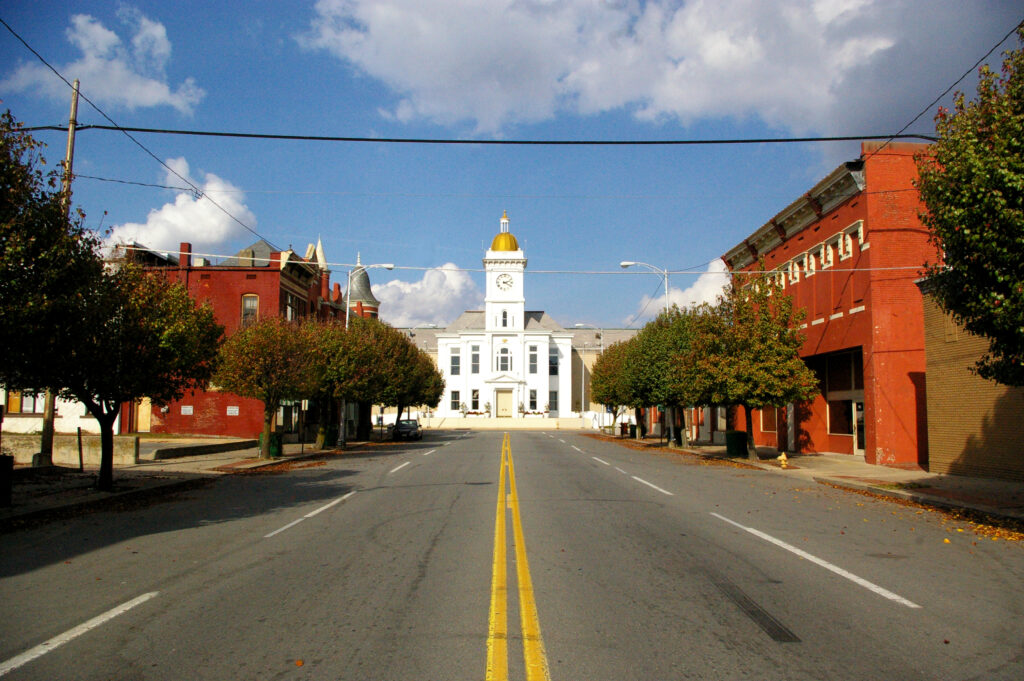
Midland, despite it’s name, is not really in the middle of anything, except, perhaps “nowhere”. Fairly isolated in west Texas, save for a proximity to Odessa. Let’s see if they can look forward to anything more than dust.
At 353PM, CT, Midland was reporting a temperature of 96 degrees with fair skies. Midland was northwest of the dry line, with a dew point in the upper 50s, compared to the dew point in Brownwood and Stephenville, which sat in the 70s. A local eddy was still producing some showers behind the primary dry line, notably over the southeastern corner of New Mexico. The trough related showers and storms over the High Plains will become less active as a storm system in the Canadian Prairie moves towards the northern Great Lakes. Onshore flow from the Gulf will still be present, and showers will be likely over south Texas, but the end of the work week should be dry in Midland. Tomorrow – Mostly sunny, High 100, Low 74 Friday – Mostly sunny, High 99, Low 75
TWC: Tomorrow – Partly cloudy, High 100, Low 74 Friday – Intervals of clouds and sunshine, High 97, Low 76
AW: Tomorrow – Breezy in the morning; otherwise, hot with sunshine mixing with some clouds; High 100, Low 75 Friday – Breezy and very warm with periods of clouds and sunshine High 99, Low 77
NWS: Tomorrow – Sunny, High 98, Low 74 Friday – Sunny, High 97, Low 76
WB: Tomorrow – Sunny, High 97, Low 76 Friday – Sunny, High 94, Low 77
WN: Tomorrow – Mostly sunny, High 98, Low 74 Friday – Mostly sunny, High 97, Low 76
CLI: Tomorrow – Sunny, High 98, Low 74 Friday – Partly cloudy, High 97, Low 75
Those showers in New Mexico dissipated before I took the image of the satellite. But storms in Texas are still roaring tonight, not threatening Midland at all.
It’s 8 days since we put together the forecast for Midland, and I can tell you that most of the country is now much cooler than it was last week. The 80 degrees I see in the forecast verification are of a bygone era. It’s in the 50s now in Midland. Proving that things are constantly changing, though, Midland will be back up in the 8os this weekend. The forecast from last Thursday was fairly simple, with warm air, and warming overnight lows to start the weekend. Decent forecasts were had by all, the best came from Weatherbug. Actuals: Friday – High 80, Low 46 Saturday – High 80, Low 57
Midland used to be the Weather Forecast Office that I would think about when thinking of severe thunderstorms, but in recent years, that focus has certainly shifted eastward. In mid-November, though, Midland could still provide a few forecast thrills.
AT 953AM, ET, Midland was reporting a temperature of 58 degrees with clear skies. An upper level ridge is parked over the Mississippi Valley, and sitting on the western flank of this ridge is allowing west Texas to remain comfortable and dry. A weak but active boundary east of the Mississippi is pushing most of the moisture in the middle of the country well away from the Lone Star State. The upper level ridge will only work to get broader while a sharply angled trough in the western US will begin to get stronger flow through it. This will lead to an increase in warm air for Midland, however the narrow but strong wave will have a difficult time translating eastward. The beginning of the weekend will be warm and pleasant for west Texas, if a bit breezy. Tomorrow – Mostly sunny, High 79, Low 47 Saturday – Sunny with a bit of a breeze, High 82, Low 53
TWC: Tomorrow – A mainly sunny sky. High 79, Low 47 Saturday – Partly cloudy skies. High 81, Low 56
AW: Tomorrow – Sunny, breezy and pleasant High 76, Low 47 Saturday – Mostly sunny and very warm High 80, Low 55
NWS: Tomorrow – Sunny, High 77, Low 49 Saturday – Sunny, High 80, Low 56
WB: Tomorrow – Sunny, High 76, Low 47 Saturday – Sunny, High 80, Low 57
WN: Tomorrow – Sunny, High 77, Low 50 Saturday – Mostly sunny, High 80, Low 56
CLI: Tomorrow – Sunny, High 78, Low 48 Saturday – Partly cloudy, High 81, low 54
Well, that is sure a pleasant forecast, isn’t it? Let’s just say it is probably good this forecast stops at Saturday. For now, the satellite is basically a picture of Texas.
The heat is on in the southwestern United States, but there will be a seasonable reprieve in the southeast. We’ll cover most of it on our 2 day trek, covering 1,325 miles. The second day will be pretty long, so travel with a second driver. The pace will be 68.8mph, which we will use to take a 550 mile chunk out of on the first day, hopefully getting us out of Texas. Let’s find out and get going.
DAY ONE (Wednesday)
Midland, Texas By Hellorawr at English Wikipedia – Own work by the original uploader, Public Domain, https://commons.wikimedia.org/w/index.php?curid=29124005
Often in the summer, cold fronts expire along the coast, and just leave a convergence zone , amplified by the daily sea breezes. That’s what to expect in the coming days, but only as far west as about Lafayette, and not too terribly far inland. This will keep the hottest and most humid air penned to the south, relatively cool, definitely drier air will populate our route to Texas. We will make it just east of Shreveport and the town of Dubberly for our initial day of driving.
DAY TWO (Thursday) Another feature of summer in the southeast when moisture feeds systems in the Midwest and Great Lakes by streaming across the region. Guidance is pretty consistent with a potential band of light rain over western Mississippi as we drive through. From there through Georgia, expect more isolated showers and storms becoming more active as the area warms up in the afternoon. the Carolinas look a little bit drier, thanks to a weak little spot of development in the Gulf Stream, which will cycle in some subsiding air. Warm — but not too hot — weather awaits in Columbia.