A lot of the conversation along the Gulf Coast this spring has involved varying degrees of the sentiment “Wow, it sure has been quiet!” And so it was when we forecast in Gulfport to round out September. The forecasts across the board lined up with the temperatures, which hit close to 90 in the afternoons. The Weather Channel was the top performer, but everyone should be happy with their score. Actuals: September 29th, High 89, Low 70 September 30th, High 90, Low 70
This drive will take 5 days, headed cross country over 2,567miles at a pace of about 67.5mph, and a target of 540 miles a day. If you are like me, perhaps you are wondering “how long would it take to travel from these two ports by sea?” According to my research: Over a month. Let’s take the car!
DAY ONE (Thursday)
Gulfport, Mississippi
Pressure is high across most of the country, which long time readers know, of course, means weather is pretty ok! The first drive of this trip will start with some low clouds, maybe some drizzle in Gulfport, but just a short jaunt inland will bring much cooler temperatures and clearer skies. we’ll make it to Forney on the east side of Dallas after what should be a pretty nice day in the car.
DAY TWO (Friday) We will continue on our northwesterly voyage through what will probably be our driest and dustiest day. The route will carry us through west Texas and the Panhandles, before coming to an end in Campo, in far southeaster Colorado.
DAY THREE (Saturday) Westerly flow throughout the Rockies is going to start inducing some surface low pressure on the lee. Jet structure is going to amplify the development of low pressure, and moisture in the southwest will draw into the Rockies. There is definitely a shot at precipitation on Saturday, and I would say it will increase around Fort Collins, and be the most likely at the end of the day, as we unload in Wamsutter, Wyoming.
DAY FOUR (Sunday) Low pressure will work to consolidate overnight in Canada, and our route will dry out considerably. The precipitation on the west side of Wyoming may briefly be wet snow, so if you want to see that, get going early. Northern Utah and southern Idaho are going to be idyllic. We’ll stop in Meridien on the western side of Boise to conclude our drive.
DAY FIVE (Monday) Low pressure will be scooting down the Pacific Coast into the Pacific Northwest as we wrap up our last day of travel. The low will bring the rain and low clouds that the Pacific Northwest is famous for, but it will be confined primarily to the area on the west side of the Cascades. The first remote chance of rain will be around Willow Lake, but the first real chances will be in The Dalles. Expect it to be a bit gloomy in Portland on our arrival.
Unlike Davenport, Gulfport IS a port, and that is how it got its name.
At 453PM, Central Time, Gulfport was reporting clear skies and a temperature of 88 degrees. With multiple tropical features in the western Atlantic, the tropical energy was redirected away from the Gulf, and the Gulf Coast was in the midst of a nice, clear stretch of autumn weather. With nothing driving traffic in the immediate region, eyes turn to Humberto and Imelda, which are going to dance together before merging through the middle of the week. As the pair of storms move off to the Atlantic, a bit of a sea breeze will return, with some afternoon storms coming back on Tuesday. Tomorrow – Mostly sunny, High 91, Low 69 Tuesday – Mostly sunny, isolated storms late, High 90, Low 69
TWC: Tomorrow – A mainly sunny sky. High 90, Low 71 Tuesday- Sunshine and some clouds. High 90, Lo 70
AW: Tomorrow – Warm with plenty of sunshine High 91. Low 70 Tuesday – Mostly sunny and remaining warm High 91, Low 70
NWS: Tomorrow – Sunny, High 88, Low 71 Tuesday – Sunny, High 88, Low 71
WB: Tomorrow – Sunny. High 86, Low 72 Tuesday – Sunny. High 88, Low 71
WN: Tomorrow – Mostly sunny, High 88, Low 71 Tuesday – Mostly sunny, High 88, Low 71
CLI: Tomorrow – Sunny, High 91, Low 71 Tuesday – Sunny, High 89, Low 70
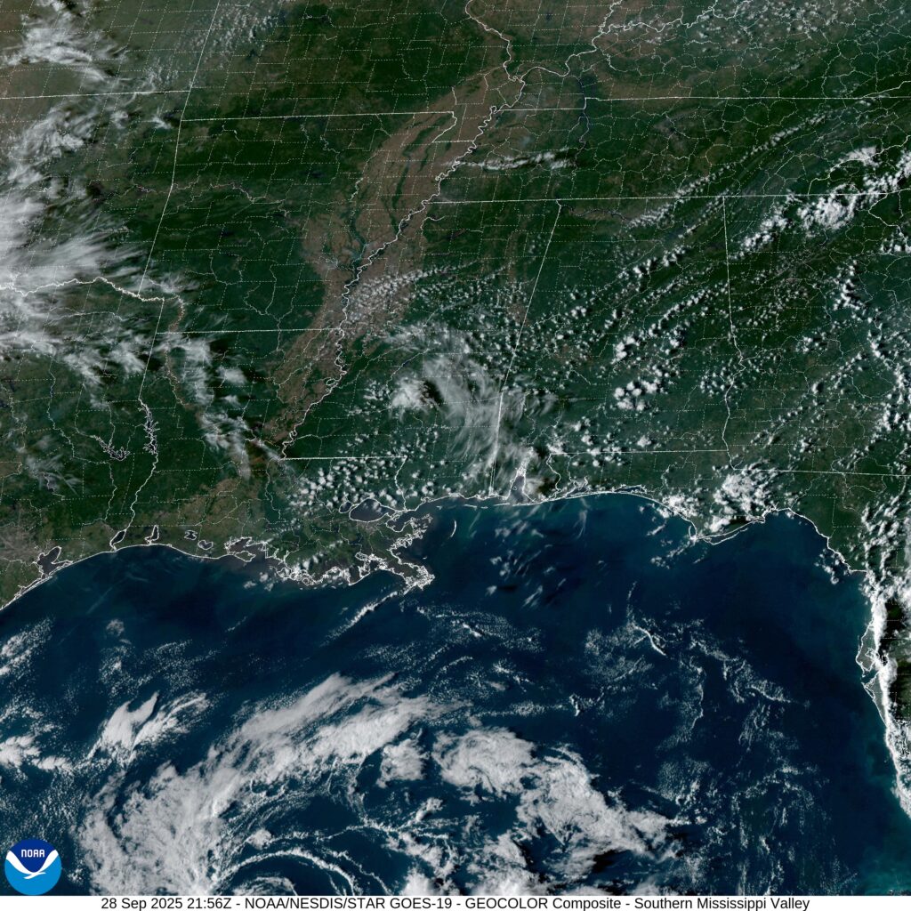
It’s not often that I am on the island with precipitation in the forecast. Also, The Weather Channel got a little bit of a refresh, which is almost as clean as this satellite image.
I mentioned in my recent post that cold air has plunged deep into the south thanks to a broad trough with brisk flow through the attendant jet streak. They didn’t care why it was cold in Gulfport, perhaps, but they knew after a rainy day on Saturday, it certainly was chilly! in fact, Sunday evening, the low temperature dipped all the way down to 33 degrees, before going even lower after our forecast period expired. The forecast was handled pretty well, though I don’t think we properly anticipated the continued cooldown on Sunday evening. It was the National Weather Service who collected the first victory of the year, though nobody had a truly miserable time of it. Except probably the locals. Actuals: Saturday – 1.18 inches of rain, High 58, Low 40 Sunday – High 47, Low 33
This is it, friends, the first individual forecast of the year. Off to the Gulf Coast, and hopefully some warm temperatures.
At 1253PM, CT, Gulfport was reporting a temperature of 48 degrees with clear skies. This will not last, however. Scattered showers are moving through Louisiana, the vanguard of a system developing off the Texas coast near Corpus Christi. A sharp upper level trough is going to aid the development of this feature, which will temporarily slow it down, but will ultimately give the storm a bit of a jolt. Fortunately, Gulfport looks to be far enough south to evade the snow and ice this storm will bring, but still chilly enough to avoid severe weather. Warm air will lift north at the leading edge of the system, and the onshore flow will almost certainly led to a stray shower overnight in Gulfport. The heavy rain associated with the core of the area of low pressure will arrive in Gulfport around mid-morning, and may feature a thunderstorm or two. By the time it passes southern Mississippi, the feature will have some momentum, and will make a hard charge through th region, exiting later in the evening on Friday, and leading to an even cooler Saturday. Fortunately, with a little bit of sunshine, Gulfport should bounce back to something closer to comfortable. Tomorrow – Rain, heavy at times with some thunder in the morning. Wrapping up in the evening, getting chilly late, High 60, Low 40 Saturday – Increasing sun, cooler, High 51, Low 37
TWC: Tomorrow – Windy with a steady rain in the morning. Showers continuing in the afternoon. Potential for heavy rainfall. High 57, low 41 Saturday – Intervals of clouds and sunshine. High 51, low 35
AW: Tomorrow – Turning colder in the morning; windy with rain High 58, Low 43 Saturday – Partial sunshine, High 52, Low 36
NWS: Tomorrow – Showers High 62, low 40 Saturday – Partly sunny High 48, Low 35
WB: Tomorrow – Showers, mainly in the morning. Locally heavy rainfall possible in the morning. High 55, Low 38 Saturday – Mostly cloudy in the morning, then becoming mostly sunny, High 50, Low 36
WN: Tomorrow – Mostly cloudy with showers, High 61, Low 39 Saturday – Partly cloudy, High 46, low 36
CLI: Tomorrow – Rain Showers, High 61, Low 44 Saturday – Sunny, High 51, Low 36
Believe it or not, not all of our forecasters put Tomorrow’s low at midnight headed into Friday. Temperatures should plateau there for a bit, and perhaps not necessarily any cooler than they will be tomorrow morning, ahead of the surge of warmer air before the rain. Did someone say rain? Here is some rain arriving in Louisiana.
We’re headed Gulfward to start the new week. This drive doesn’t quite mirror our drive leading into the weekend, and will lead to a longer drive, lasting into a third day, while also at a pace that is faster, covering 67.5mph. This will allow us to cover 539.7 miles the first two days, leaving the rest of the 1519 miles for Wednesday.
DAY ONE (Monday)
Manchester, New Hampshire
In a manner that is frighteningly similar to the one seen on our way up to Manchester last week, a wave will be moving into the Mid-Atlantic just as we are driving through the area. The drive through New England and downstate New York should be dry, if increasingly cloudy. The threat for rain will pick up around Allentown, and will persist through the remainder of the drive through the Keystone State, as well as the snips of Maryland, West Virginia and Virginia we see (We will touch 8 states in all through this drive). The day will end with some light rain, as it will have been spotty throughout the afternoon, in Stephen City, Virginia, which is on the south side of Winchester.
DAY TWO (Tuesday)
A big lingering area of low pressure is hanging out in the Gulf Stream, and is slowing down any progress through the Eastern Time Zone. There won’t be an organized system, so to speak, but the lingering showers will turn into morning fog on Tuesday up against the Blue Ridge Mountains, with rain picking up pretty quickly again as the day begins. As we start to get into the mountains, we’ll eventually get to the western face of the mountains, in Tennessee, and we should start to enjoy some drier pavement from about Bristol to Chattanooga. It won’t remain entirely dry, as a reinforcing shot of cold air might bring some more wet weather to Tennessee as the lingering moisture starts trying to organize late in the day. We won’t spend much more than 15 miles in northwest Georgia, but we are still going to post up for the night in Slygo.
DAY THREE (Wednesday)
The NHC is monitoring a developing feature off the coast of Nicaragua, which will start drifting further to the north through the next couple of days. Models are starting to agree that it is looking more and more like it will become a tropical storm, and ultimately, a hurricane before making land fall, unfortunately probably along the Gulf Coast. Guidance suggests that landfall will come around Fort Walton Beach on Thursday, which furthermore means our drive on Wednesday towards the Gulf Coast will be very dependent on the pace of the storm. I suspect we will see a little bit of rain in Alabama, but it will clear out fairly quickly. Ironically, moisture will be flowing off shore, which isn’t generally a great way to produce a lot of storms, so I don’t think we will see much rain. In fact, I would say by the time we reach Gulfport, it should be dry. Won’t last, but my forecast doesn’t go beyond Wednesday.
It was a really tough middle of February, but late last week, the recovery and a look towards spring began. We put together a forecast for Gulfport, which, even along the Gulf Coast, endured unusually cold weather. They started bouncing back on Friday and Saturday, however, with temperatures almost touching 60 on Saturday. It’s not warm, especially in southern Mississippi, but it was getting there. To go along with the positive vibes, there was a three way tie atop the leaderboard. Accuweather, Weatherbug and Forecast.io secured the top spot. Actuals: Friday, High 56, Low 33 Saturday – 57, Low 28
You know all those times where I said that forecasts would soon be coming more quickly? Well, we are now at those times. Another forecast, and another for southern Mississippi.
AT 953PM, CT, Gulfport was reporting a temperature of 40 degrees with overcast skies. North winds continued to bring cold air to the region, behind a cold front that lay between Pensacola and Tallahassee. Sub freezing temperatures continued to the north, where ice, snow and cold have drastically impacted basic utilities. The jet trough is restructuring the surface area of low pressure. Presently, there is an elongated surface trough, which is producing the rain and snow seen up and down the coast, but the base of the jet trough will interact with the low pressure channel along the Gulf Stream through the day tomorrow. As a more organization comes to the surface feature, low level moisture and clouds will pull away from Gulfport. It may not be warm, but Friday afternoon and Saturday will at least have sunshine. Tomorrow – Mostly cloudy early, then clearing, High 52, Low 35 Saturday – Sunny, feeling warmer, High 58, Low 30
TWC: Tomorrow – Partly cloudy skies. High 51, Low 32 Saturday – A mainly sunny sky High 55, Low 30
AW: Tomorrow – Mostly sunny and cold High 50, Low 32 Saturday – Plenty of sunshine, but cool High 56, Low 28
NWS: Tomorrow – Mostly cloudy through mid morning, then gradual clearing High 49, Low 31 Saturday – Sunny, High 56, Low 27
WB: Tomorrow – Partly cloudy in the morning, then clearing. High 49, Low 33 Saturday – Sunny, High 56, Low 28
WN: Tomorrow – Mostly sunny, High 49, Low 32 Saturday – Sunny, High 55, Low 29
FIO: Tomorrow – Partly cloudy throughout the day High 51, Low 33 Saturday – Clear throughout the day. High 56, Low 30
I am a little more optimistic for a warm up. Full sun in southern Mississippi should at least get a little closer to 60, right? The cool, moisture rich air of the southeast is leading to a lot of clouds tonight.
First the good news: there were no thunderstorms last Wednesday or on the 4th of July for the city of Gulfport. Now the bad news: it was really stinkin’ hot. Low to mid 90s in the afternoon, and a low of 75 each morning. I hope the air worked for locals, or at least they have grown accustomed to sweating through the night. Accuweather had a dry forecast and the second best temperature forecast, which meant they started July off on a good note. Actuals: Wednesday – High 92, low 75 Thursday – High 94, low 75
If you haven’t ever been to Gulfport, or know where it is located, Gulfport is a port on the Gulf.
At 853AM, CT, Gulfport was reporting a temperature of 86 degrees with clear skies. It’s the season for light off shore convection, and indeed, there is already some off the Mississippi Delta. These Gulf Coast storms tend to be more widespread than anticipated in model guidance, and an intense rain shower cannot be ruled out today. In the parlance, the Gulf is “open” meaning there is little to no counterflow to sea breezes, and sultry air is free to invade the coastal areas. This tends to mean that in the afternoon, there will be enough instability for occasional showers and thunderstorms, particularly a few miles inland where the sea breeze loses momentum, with storms then drifting back towards the coast as the sun sets. This will probably be the pattern each of the next two days in Gulfport, and truly, the entire Gulf Coast. Tomorrow – Mostly cloudy with a few thunderstorms, High 93, Low 76 Thursday – Mostly cloudy with a few thunderstorms, High 95, Low 76
TWC: Tomorrow – Partial cloudiness early, with scattered showers and thunderstorms in the afternoon. High 90, Low 76 Thursday – Sunshine and clouds mixed. A stray shower or thunderstorm is possible High 93, low 77
AW: Tomorrow = Intervals of clouds and sunshine High 92, low 76 Thursday – Mostly sunny High 95, Low 76
NWS: Tomorrow – A 30 percent chance of showers and thunderstorms, mainly after 1pm. Partly sunny High 91, Low 76 Thursday – Mostly sunny, high 93, Low 76
WB: Tomorrow – Partly cloudy, slight chance of showers and thunderstorms in the morning, then chance of showers and thunderstorms in the afternoon, High 91, low 75 Thursday – Sunny in the morning then partly cloudy with a 20 percent chance of showers and thunderstorms in the afternoon High 93, low 75
WN: Tomorrow – Partly cloudy with scattered storms, High 92, low Low 77 Thursday – Partly cloudy, High 93, Low 77
FIO: Tomorrow – Humid and partly cloudy throughout the day. High 91, low 78 Thursday – Humid and partly cloudy throughout the day. High 93, Low 78
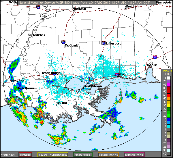
Hot. Humid. Mississippi. Here is some of this morning’s off shore convection on radar.