Rarely do we see a day in which forecasts across the board grade out at an A for everyone. It’s unheard of for a couple of days that were as miserable as they were in Durham a couple days before Halloween. Temperatures lingered in the 50s, suppressed by a feature moving through the Carolinas and smothering the region with rain and wind. On the 28th, the winds gusted to nearly 40mph to go along with the 3/4″ of rain. The weather was miserable, but the weather followed along with what everyone anticipated. This meant this was a three way draw between Victoria-Weather, The Weather Channel and Accuweather. Everyone crowded behind us in a well fought, well done forecast battle. Actuals: October 28th, .76″ of rain, High 51, Low 48 October 29th, .07″ of rain, High 57, low 48
Durham is one of the three members of the “Research Triangle” in eastern North Carolina, and is famous also for being the home of Duke University, who have historically had a strong basketball program.
At 815PM, ET, Durham was reporting a temperature of 52 degrees with rain. There was an area of low pressure off the coast of South Carolina, and to say the least, it has been a robust rain producer, and almost the entire state east of the mountains was experiencing rain this evening. The feature is associated with a robust seasonal jet stream, and will shift into the north Atlantic, where it will help to establish a steering mechanism to keep Hurricane Melissa away from the US mainland. The pattern across the US is quite active this week. While rain will diminish by late on Tuesday, but a deeper digging trough with it’s own area of surface low pressure will be sliding through the southern US. By Wednesday, the stalled boundary associated with the low in the Atlantic will link with the rising warm front, bringing rain back into the forecast for the morning. Wednesday will see temperatures pop a bit, with some thunderstorms coming in after sunset. Tomorrow – Showers through the day, High 50, Low 47 Wednesday – Rain early, then some thunder late, High 58, Low 48
TWC: Tomorrow – Rain, High 51, Low 48 Wednesday – Considerable cloudiness with occasional rain showers. High 56, Low 46
AW: Tomorrow – Breezy and cool with rain High 51, Low 46 Wednesday – Occasional rain and drizzle in the morning followed by periods of rain and a thunderstorm in the afternoon High 57, Low 47
NWS: Tomorrow – Rain. High 52, Low 47 Wednesday – Rain likely before 8am, then showers likely, mainly after 2pm. Cloudy, High 58, Low 47
WB: Tomorrow – Rain. High 53, Low 48 Wednesday – Rain likely with areas of drizzle in the morning then showers likely in the afternoon High 55, Low 47
WN: Tomorrow – Cloudy with showers, High 52, Low 47 Wednesday – Mostly cloudy with rain likely, High 58, Low 47
CLI: Tomorrow – Rain showers, High 51, Low 47 Wednesday – Rain Showers, High 55, Low 47
Sorry, Durham. Wish I had better news for you. Look at all this rain!
The threat for rain was introduced in every forecast for Durham back in the first week of December, but It held on to the very end of the forecast period. This allowed forecasters who skewed to a warmer forecast to get a a little bit closer to that perfect forecast. The warmest outlet of them all was Victoria-Weather, and our forecast turned out to be very good. Actuals: December 5th, High 55, Low 31 December 6th, .08 inches of rain, High 60, Low 48
Another summer, and another scary hurricane has made landfall somewhere in North America. Laura, while a strong storm and having made landfall in the US may not be as well remembered as storms like Michael, Maria, Dorian or Harvey for a variety of factors. Those factors are, of course, Covid-19, Civil unrest and the virtuous fight for social justice and racial equality, and the ongoing Republican National Convention. Laura was, depending on your home market, not even in the top three news stories of the day.
It’s too bad for a variety of reasons, not the least of which is that it turns attention away from those residents who were greatly impacted by this storm, particularly in Cameron and Lake Charles, Louisiana, but also because the forecasts were so good, and apparently so well heeded, the death toll is not as large as one might suspect from a strong storm striking the US Mainland.
in a time when science is so heavily scrutinized, it is important to remind the populace that we usually get it right, and the recommendations for safety and well being are rooted in good intentions and factual assessment. That, and the pain that Laura has brought (even through it came with a lower casualty total) will likely fly under the radar, so to speak
Another excellent forecast that came up in the last couple of weeks was the one for Durham, which was posted here about two weeks ago. Victoria-Weather and the National Weather Service collected the top forecasts thanks to solid temperature outlooks, despite heavy rain that was going to fall in the area.
Actuals: August 14th, .63 inches of rain, High 88, Low 73 August 15th, 1.37 inches of rain, High 84, Low 72
After so many lengthy road trips lately, here is a refreshing change. This trip will take the better part of day, about 6 hours, and cover 385 miles. We will pass through the DC Metro and start our day in the mountains, so our pace of 66.5mph is actually pretty good.
Cumberland, Maryland
The mid-Atlantic is at the mercy of a pair of systems that are about a thousand miles apart. The first is a developing area of low pressure off the coast of Chesapeake Bay, and the second is wafting through Hudson Bay. The Hudson Bay feature is dragging a pretty effective cold front, given its length, through the Great Lakes and will press towards the Appalachians by tomorrow afternoon. It won’t be particularly active though, given the offshore feature’s presence, but it will be come increasingly cloudy as it departs. The initial part of the route through DC will be mostly cloudy, with some light rain to South Hill, Virginia, which will become more likely from there to Durham.
Time to get this forecast wagon hitched and on the road!
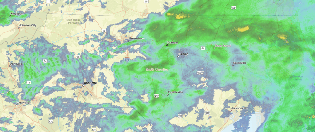
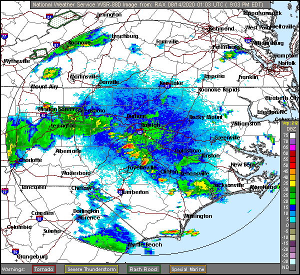
At 953PM, ET, Durham was reporting a temperature of 73 degrees with clear skies. There was a line of very weak thunderstorms extending from north of Fayetteville to south of Mount Airy, but it was continuing to diminish for the night. A lower level trough over the mid-Atlantic is churning up a few showers and thunderstorms throughout the area, and the persistence is leading to the threat of flash flooding where the storms sit in place, but it is clear and humid where they are not. The low level wave will shift off shore and low pressure will deepen rapidly in the Gulfstream, The deepening low pressure will extend west to the coast, with moisture building into the Carolinas again on Saturday. Before that, a little bit of dry air will dig in thanks to the circulation of the deepening low, but the beginning of the weekend might be a bit drearier. Tomorrow – Partly cloudy with late showers and storms, High 88, Low 73 Saturday – Scattered showers and storms, High 85, Low 73
TWC: Tomorrow – Mostly cloudy in the morning with scattered thunderstorms developing later in the day. High 86, Low 71 Saturday – Thunderstorms. Potential for heavy rainfall. High 82, Low 72
AW: Tomorrow – Mostly cloudy with a couple of showers and a heavy t-storm, mainly later; watch for flash flooding High 86, Low 71 Saturday – Mostly cloudy and humid with a couple of showers and a thunderstorm around, some can be heavy late High 84, Low 72
NWS: Tomorrow – Showers and thunderstorms likely, mainly after 3pm. Mostly cloudy, High 88, Low 72 Saturday – Showers and thunderstorms, mainly after 8am High 85, Low 72
WB: Tomorrow – Cloudy with a slight chance of showers and thunderstorms in the morning then partly sunny with showers and thunderstorms likely in the afternoon, High 84, Low 72 Saturday – Showers and thunderstorms, High 81, Low 72
WN: Tomorrow – Mostly cloudy with thunderstorms likely, High 88, Low 72 Saturday – Mostly cloudy with thunderstorms, High 86, Low 72
FIO: Tomorrow – Possible light rain and humid throughout the day. High 86, Low 71 Saturday – Rain and humid throughout the day. High 83, Low 72
Interestingly enough, we just started watching the Last Dance tonight, and here we are, forecasting for Durham. Maybe not that interesting. Anyways, here is a look at the radar, showing those isolated storms. There is a lot of ground clutter that is making it look worse than is true on the ground.