When we put together the forecast for Chicago at the end of February, there was a strong southwest to northeast jet, that really hasn’t changed a whole lot, even now as we enter the middle of March. One change, I suppose, is that the jet has lifted a bit to the north, so Chicago is now warmer, but back in February, the Windy City would get snow on the north side of a feature, followed by cold air. That’s the pattern we followed leading into the last weekend of the month. The cool down rate was a bit challenging, and gave way to some spotty forecast consistency, but ultimately, the Weather Service (who allowed a Midway Airport specific forecast, unlike nearly all other comers) grabbed a victory. Actuals: Friday 2/25 – .04 inches of liquid in light snow, High 31, Low 20 Saturday 2/26 – High 33, Low 16
The Chicago area covers a lot of territory, and even covers some smaller microclimates, wrapping around Lake Michigan as it does. The site we use to verify defaults to Chicago-Midway, so we will as well. Just know, what happens at Midway doesn’t always happen at O’Hare.
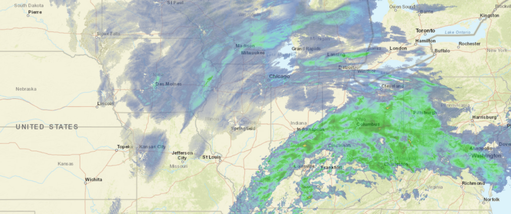
At 829PM, CT, Chicago Midway was reporting a snow with fog and low clouds. A vigorous southwest to northeast trough runs from Texas to the Great Lakes, and a perturbation in the Upper Midwest has led to a surface feature that is presently organizing over western Kentucky, extending an inverted trough through northern Illinois and bringing the snow that is being seen in the region. The low will continue to organize and jet off to the northeast, pressed on by the swift flow aloft. After the surface system and abetting upper level perturbation aloft shift out of the region overnight tonight, expect clearing to take hold. The jet to the south will remain in place, keeping any hope for warmth at bay through the weekend, but the swift flow aloft will lead to some mid to high level clouds, which will keep it a couple of degrees warmer overnight. After flurries end early tomorrow morning, Chicago will be brisk but dry through Saturday. Tomorrow – Early AM Flurries, then a bit brisk, mostly cloudy, High 30, Low 21 Saturday – Partly cloudy, breezy, High 36, Low 20
TWC: Tomorrow – Mostly cloudy skies. A few flurries or snow showers possible. High 29, Low 24 Saturday – Sunny skies High 36, Low 18
AW: Tomorrow – A couple of flurries early in the morning; otherwise, mostly cloudy and cold; watch for icy spots in the morning High 29, Low 23 Saturday – Mostly sunny; breezy in the afternoon High 36, Low 19
NWS: Tomorrow – A chance of snow between 8am and 2pm, then a chance of flurries after 2pm. High 29, Low 23 Saturday – Sunny, High 33, Low 18
WB: Tomorrow – Mostly cloudy and a chance of flurries and a slight chance of light snow in the morning, High 27, Low 22 Saturday – Sunny, High 32, Low 18
WB: Tomorrow – Mostly cloudy with scattered snow showers, High 28, Low 25 Saturday – Sunny, High 34, Low 20
FIO: Tomorrow – Foggy overnight and in the morning. High 29, Low 20 Saturday – Clear throughout the day. High 34, Low 16
A little snowy in Chicago, but we are at the end of it. Only The Weather Service specifically directs to Midway in their forecast offerings, so we will see if that has any bearing on how things turn out.