Our first forecast of the year took us to Atlantic City, which was bracketed by waves to the north and south. They pushed each other away, which kept Atlantic City dry. That’s great news for New Jerseyans, but also the people who enjoy accurate forecasts. Temperatures were pretty reliable, including the bump in temperature on Sunday as low pressure scooted through western Atlantic. The first forecast of the year was a shared victory for The Weather Channel and National Weather Service. Actuals: Saturday – High 33, Low 19 Sunday – High 38, Low 26
Grade – B – Just a reminder, this year our grade now represents the consensus score for all forecasters. A b for the group is pretty good!
Our trek on this day is going to cover the nation, and will last a week. A real American road trip. The trip is going to span 2,846 miles, which covers about 66 miles an hour. This lengthy trip is going to be broken apart in about 524.5 mile daily chunks.
DAY ONE (Wednesday)
Atlantic City, New Jersey
Low pressure in the Great Lakes is doing something we can all appreciate: Moving quickly. The low will be out of the picture by the time we start heading out on Wednesday morning, and while the models aren’t capturing the Lake effect snow very well, it doesn’t much matter. We will indeed be driving just south of Lake Erie, but I don’t think the fetch will be right to bother us in northern Ohio. The drive will end in Sandusky, Ohio of conclude the first day on the road.
DAY TWO (Thursday) Thursday isn’t going to be great. We will start out fine, and make it through Chicago with little problem, but our next fast moving feature will be emerging from the Plains, and getting stronger and wetter before slamming into the Midwest. We will encounter rain starting around Joliet, and really getting going as we reach the Quad Cities. The rain will continue, heavy in spots, through Iowa City and on to our destination for the night in Williamsburg, Iowa, drenched.
DAY THREE (Friday) The back side of our little storm will transition over to a bit of light snow while we rest in Williamsburg. The core of the system is going to continue on to the Great Lakes, and while there won’t be accumulation, the flurries on top of refreezing ice could make the entire drive through the Hawkeye state. No precipitation while we travel in Nebraska, but there is going to be a weak lee trough kicking up clouds as far east as Paxton, Friday’s destination.
DAY FOUR (Saturday) After a couple of tougher days, we might be a bit trepidatious about hitting the mountains. Fortunately, a ridge will be moving into the area, and driving the Nebraska Panhandle and the bulk of Wyoming will be pretty easy. We won’t make it out of Wyoming on Saturday, stopping for the day in Piedmont.
DAY FIVE (Sunday) We have a bit to go to wrap this trip up, but by this point, we will have undergone a significant change to the pattern. Surface high pressure off shore is stifling that Pineapple Express that has been so problematic this winter, and clear skies beckon from Utah, Nevada and on to California.
According to Google, it would be almost 8 hours to fly from the Bay City area to Atlantic City. It’s eleven and a half hours to make that drive. Combined with the wait at the airport, getting your bags, rental cars, etc. It’s probably shorter and definitely easier to drive. We’ll do this in one big day, covering the 741 miles at a pace of 64.4 miles.
Bay City, Michigan
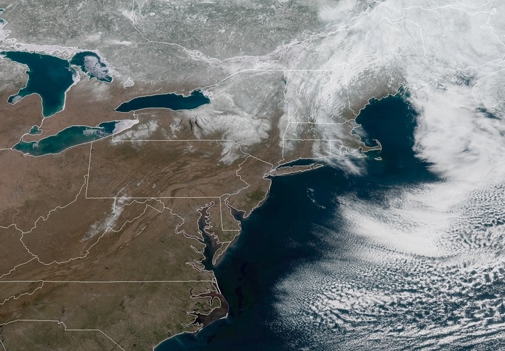
As has been the case for weeks now, there is another feature rippling through the Great Lakes. This one is moving in from the central Plains, which is further south than anything we’ve seen for a while. That means it hasn’t really been able to tap into much moisture yet, which is great, because there isn’t any precipitation yet. It is cloudy now in Bay City, which will keep things from cooling too much overnight. Temperatures, in fact, will start to warm up overnight, which means the light precipitation moving through lower Michigan tomorrow morning will fall as rain, with a bit of a mix just as we get started. The threat will mostly wane after we pull through Toledo. Clouds will chase us into Pittsburgh, but by the time we get to the Allegheny Mountains, the sun should pop out. The low pressure center is going to be pretty broad, and the rotation associated with it will carry off shore. The southwesterly fetch could lead to a bit of low clouds and fog late in Atlantic City upon our arrival.
Is is a good sign that the first forecast of the year is from a city notable for it’s gambling?
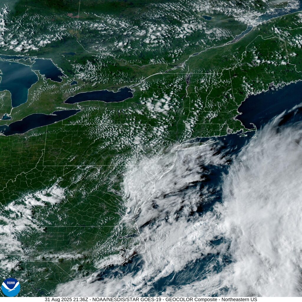
At 454PM, ET, Atlantic City was reporting a temperature of 29 degrees with clear skies. The region is between two jet streak troughs, which is continuing to lead to a deep area of low pressure over Nunavut that continues to instigate Lake effect snow in the eastern Great Lakes. The southern flank of the trough is going to provide a nurturing environment for cyclogenesis in the Lower Mississippi Valley initially, moving east towards the Carolinas. Low pressure will continue to move eastward today from its present home in Arkansas, eventually reaching the Gulf Stream by tomorrow evening. The feature will subsequently continue to deepen and move north along the oceanic current. The pattern aloft will keep the unsettled weather offshore, and the welling from the south may lead to a bit of a warm up for Sunday. Not significant, but every degree this time of year helps. Tomorrow – Mostly sunny, High 37, Low 22 Sunday – Mostly cloudy, High 40, Low 27
TWC: Tomorrow – Cloudy skies High 33, Low 22 Sunday – Partly cloudy. High 37, Low 26
AW: Tomorrow – Breezy with some sunshine giving way to clouds High 34, Low 25 Sunday – Mostly sunny and breezy High 38, Low 30
NWS: Tomorrow – Increasing clouds High 33, Low 22 Sunday – Mostly cloudy, then gradually becoming sunny High 38, Low 27
WB: Tomorrow – Partly sunny in the morning then becoming cloudy High 31, Low 25 Sunday – Mostly sunny. High 36, Low 29
CLI: Tomorrow – Overcast High 34, Low 23 Sunday – Sunny, High 38, Low 28
There is going to be a bit of a range inland where the airport lies and the city center. so we will see how the forecast plays out. Here is the Accuweather regional forecast, via ABC news in Philadelphia.
Usually, when I put together my forecasts, I like to see what other outlets are saying. We are all using NWS models, so why shouldn’t we look at their forecasts a little bit as well? Anyways, I clearly forgot to do that with our forecast in Atlantic City, because my low temperature forecasts were 5 or 6 degrees cooler than everyone else. Surely I would have at least called that out in the summary at the end of the forecast. Whatever the case, I was right, and Victoria-Weather, with our cool overnight lows won the forecast in the same way the nights passed in Atlantic City — comfortably. Monday – .01 inches of rain, High 75, Low 55 Tuesday – High 76, Low 54
I have a NASCAR race on in the background, which makes me think that we can cover the 1,529 miles of this trip in no time. Really, though, let’s play it cool and instead make the drive in about 3 days, leaving the third day the shortest. and drive at a safe speed of 68mph, and about 547 miles a day. We will save our poor choices for Atlantic City.
DAY ONE (Monday)
Lawton, Oklahoma
There is an eroding dry line that is washing out in the central Plains. This is producing some showers from about the Oklahoma City area to Springfield, Missouri, and there is no reason to think that this instigator will move much tomorrow. It likely won’t be as widespread as it is today. I would say the best threat will be in the higher terrain around the Ozarks, but should be fully wrapped up before we reach Sullivan, MO. Definitely before we hit Fenton, on the southwest side of St. Louis and our destination for the night.
DAY TWO (Tuesday) Our weak trough is going to start to consolidate and turn around over night. It’s going to shift towards the Tennessee Valley, which should keep it juuuuuust far enough south to keep us dry for the day. There will be a few dark clouds dappling the sky as we continue east, and they will probably linger thorughout the day. Aside from maybe a sprinkle early in the morning as we pass through St. Louis, I think we are probably OK. The best bet for another shot of rain, albeit low, will come in the last couple of hours, from Columbus to Bannock, which is just outside of Wheeling, and our destination for the night.
DAY THREE (Wednesday) That same trough will waste itself on the Appalachians and spread along the range. There will be some splashes of rain, particularly on the western faces of the range for the first part of the day. We’ll have rain through about Bedford, after which point the weak system will have a tough time transcending the Appalachians. The sun will be shining in Atlantic City when we pull in.
After bouncing around the middle of the country recently, we will now head to the East Coast, where we will probably see things like “the Gulf Stream” mentioned a few times.
At 454PM, ET, Atlantic City was reporting a temperature of 74 degrees with clear skies. There is a thatch of clouds over Delaware Bay, associated with an upper level trough. There is a jet streak over the western Atlantic, but surface high pressure is keeping things rain free in the mid-Atlantic. There is a bit of moisture in the middle of the country that will struggle to ascend the Appalachians. Low pressure following the Gulf Stream is moving at the eastern periphery of coler air, and the northerly flow in New Jersey will keep the region unseasonably cool. Tomorrow – Mostly sunny, High 74, Low 56 Tuesday – Mostly cloudy, High 76, Low 55
TWC: Tomorrow – Sunshine and clouds mixed High 73, Low 60 Tuesday – Partly cloudy High 74, Low 60
AW: Tomorrow – Partly sunny and windy; a nice afternoon for outdoor activities High 74, Low 62 Tuesday – Nice with plenty of sunshine High 72, Low 61
NWS: Tomorrow – Sunny, High 75, Low 64 Tuesday – Sunny, High 75, Low 62
WB: Tomorrow – Sunny, High 70, Low 64 Tuesday – Sunny, High 72, Low 63
WN: Tomorrow – Mostly sunny, High 74, Low 64 Tuesday – Mostly sunny, High 74, Low 63
CLI: Tomorrow – Light rain showers, High 73, Low 59 Tuesday – Partly cloudy, High 74, Low 59
Looks like south Jersey is in for a good Labor Day. Clouds entering the area are high, and not as threatening as they might look.
Wow, what a short trip! We are going from New Jersey to northern California, on a journey that is 2 full days shorter than the last one. We will cover 2,946 miles over 5 1/2 days at a pace of about 67 miles an hour, or 535.6 miles a day. Really, this is going to be a piece of cake, gang.
DAY ONE (Wednesday)
Atlantic City, New Jersey
Driving from Atlantic City to Santa Rosa is a job that seems like it should be done in a convertible. Probably yellow. All to say that a winters drive along this route seems cruel. It’s going to start very chilly as we depart from the Jersey Shore and cut through Pennsylvania. The major storm now on its way out of town is bringing strong northerly winds to the eastern Great Lakes. That is typically a good recipe for Lake effect snows, and sure enough, we will probably encounter some bands of heavy snow around the west Cleveland suburbs to Lorain. It will lighten up, but not disappear as we head on into Sandusky.
DAY TWO (Thursday) Winds will taper off and so too will any lingering snow threat around Sandusky, giving us a clean start for the day. Still too chilly for that yellow convertable, though. We’ll head west through northern Indiana and Illinois, and will be between Cedar Rapids and Des Moines as our Thursday wraps in Brooklyn, Iowa. A weak clipper spiraling through the Upper Midwest will bring a threat for snow as we sleep.
DAY THREE (Friday) The clipper won’t do much for accumulation, and will essentially leave southern Nebraska alone. As we get going on Friday, there might be extra traffic in Des Moines, but not enough to ruin our day. The sky will be clear, but the clipper will have brought in another batch of cold air. Expect our stops to be chilly, but will start to be a bit warmer when we stop for the night in Brule, Nebraska, in the first reaches of the Panhandle.
DAY FOUR (Saturday) Another batch of disturbed weather will be arriving in the northern Rockies over the weekend. This feature is coming from the Gulf of Alaska, so will have spent a good deal of moisture before it arrives on the scene. Snow will probably still make an appearance throughout Wyoming, particularly on the western and northern faces of terrain, with plenty of clear air to appreciate as well. The mountain snow, valley dry pattern will continue into Utah, where we will stop at Emory, which lies in the Wasatch east of Salt Lake City.
DAY FIVE (Sunday) We will leave the snow behind in the Rockies, because the Great Basin is going to be quite dry, and quite sunny. It will still be brisk, but we should drive through Nevada with no weather related concerns, though obviously one may need to contend with gambling temptations. Especially after leaving Atlantic City. Our day will end in Fernley, which lies just outside of Reno.
DAY SIX (Monday) It can be dicey this time of year, passing Truckee, as you never know when you are going to get an 8 foot snow storm, but that won’t be a concern on Monday. We’ll be able to head closer to the Bay Area, and with the sun, we might be tempted to crack a window. It will be in the upper 50s or low 60s when we finally reach Santa Rosa.
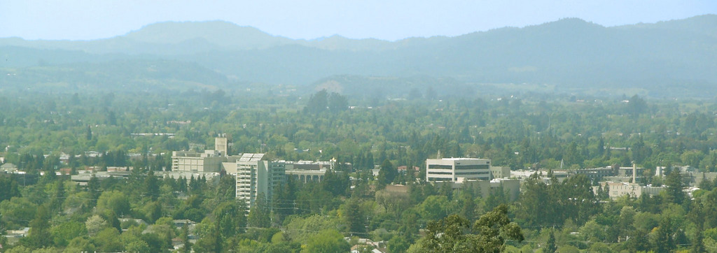
Santa Rosa, California
By JLankford – wikitravel, Public Domain, https://commons.wikimedia.org/w/index.php?curid=37654846
November is coming to a close, and we are reaching the final month of 2021. We’ll welcome the month with a 3 day road tri from the Garden State to the Lone Star State. It’s going to be a 1790 mile journey, at a 66mph pace, or for 530 miles on days one and two, with a long drive through the heart of Texas on Friday.
DAY ONE (Wednesday)
Atlantic City, New Jersey
The train of systems moving through the country right now is following a Canadian track. There are little lobes of low pressure swinging south towards the Great Lakes, bringing rain and snow there, but that moisture doesn’t appear likely to traverse the Poconos, and we will head through the Mid-Atlantic with some high cloud cover, but it won’t be a bad day by any stretch of the imagination. We’ll make it to southwestern Virginia after our fist day, stopping in Chilhowie, which is about half an hour from the Tennessee border.
DAY TWO (Thursday) Low pressure will continue to barrel through Canada but is getting stronger and more well organized, preparing to doink New England just before the weekend. Some moisture will continue to dangle as far south as the high terrain of West Virginia and Virginia, but it should be ok in Chilhowie. As we traverse Tennessee the long way, we will enjoy good driving conditions and a lot of sun. We’ll end up in te northern suburbs of Memphis to end the day.
DAY THREE (Friday) As warm high pressure moves into the southeastern US, we are looking at a positive start to our Friday drive. The ridge moving east will bring about some return flow on the west side of the ridge. This moisture rich flow will probably not result in showers or storms, but that is a possibility that can’t be discounted south of Hillsboro and into San Antonio. Expect some haze and fog overnight when we reach San Anotnio, and the soupy atmosphere I think we all thought we left behind.
March Madness is fully underway, so Vegas is bustling this weekend! Lets take a look at Atlantic City, the Vegas of the East!
At 154pm EDT, the temperature at Atlantic City, NJ was 49 degrees under fair and breezy conditions. High pressure is sitting over the East Coast currently, making for very pleasant conditions in the Atlantic City area. High pressure will shift out over the Atlantic tomorrow but will continue to keep the area dry, though clouds will increase throughout the afternoon and evening hours. A quick-moving low pressure system will shift out of the Ohio Valley overnight Sunday into Monday, bringing rain to the area by midday Monday. It’s a quick-hitter though, and will clear out by Monday evening, ushering in colder air behind it. It’ll be dry for the rest of the week as high pressure builds back in.
Sunday: Some afternoon clouds. High 57, Low 29.
Monday: Overcast, some shower activity. High 48, Low 35.
TWC: Sunday: Mostly cloudy. High 56, Low 32.
Monday: Cloudy, chances of rain. High 49, Low 43.
AW :Sunday: Times of clouds and sun. High 55, Low 35.
Monday: Mostly cloudy, a little rain. High 52, Low 45.
NWS: Sunday: High 55, Low 32.
Monday: Rain likely. High 47, Low 41.
WB: Sunday: Sunny. High 53, Low 33.
Monday: Rain expected. High 49, Low 44.
WN: Sunday: Mostly sunny. High 55, Low 32.
Monday: Mostly cloudy with light rain likely. High 47, Low 42.
FIO: Sunday: Mostly cloudy and breezy starting in afternoon. High 53, Low 36.
Monday: Overcast throughout the day. High 51, Low 41.
It’s a picture perfect day today! Tomorrow will be more of the same before a system finally makes it way into the area on Monday.